Texas Spring 2017
Moderator: S2k Moderators
Forum rules
The posts in this forum are NOT official forecast and should not be used as such. They are just the opinion of the poster and may or may not be backed by sound meteorological data. They are NOT endorsed by any professional institution or STORM2K.
-
weatherdude1108
- Category 5

- Posts: 4172
- Joined: Tue Dec 13, 2011 1:04 pm
- Location: Northwest Austin/Cedar Park, TX
Re: Texas Spring 2017
We got a nice little soaking at work. Not sure about house. The rain cleared out the green crud for now down here. Here's to more rain possibilities with a series of upper level systems. I remember upper level low-related night time linear MCS storms occurred with regularity in Spring in San Antonio when I was little. They'd wake me up in the middle of the night with the lightning, heavy rain, and winds.
FXUS64 KEWX 242020
AFDEWX
Area Forecast Discussion
National Weather Service Austin/San Antonio TX
320 PM CDT Fri Mar 24 2017
.SHORT TERM (Tonight through Saturday Night)...
Pacific front/dry line was near the I-35 corridor mid afternoon.
Dry slotting has occurred across the southern I-35 corridor. Farther
northeast aircraft soundings near AUS indicate the mid level cap
weakening. There is still a window through late afternoon and early
evening where a strong to marginally severe storm or two could form
across the EWX CWA near and east of U.S. 77. However the better
threat this afternoon and into tonight will be northeast of the area.
A secondary push/front will move into the area after midnight.
The latest few HRRR runs were showing the possibility of convection
developing along this boundary overnight across the far eastern CWA.
In addition, with the initial front/dry line slowing down there will
be a window for fog late tonight across the far southeast counties
before the secondary push of drier air arrives. Sunny and dry on
Saturday.
&&
.LONG TERM (Sunday through Friday)...
A progressive pattern will occur through the upcoming week. On
Sunday a weak shortwave will pass through the Southern Plains. A warm
front looks to come back into the CWA Sunday morning and then a dryline
gets dragged east into the western CWA Sunday afternoon. This will
lead to a warm day, especially across the southwest CWA where highs
could climb into the mid 90s. Upper 80s to low 90s are expected
elsewhere. A weak cold front looks to enter the area Monday and
results in highs a degree or two cooler.
Models are then consistent with an upper level low digging into the
Four Corners Tuesday and a rapid moisture return taking place across
South Central Texas ahead of it on Tuesday. Isolated to scattered
showers and storms are possible during the day on Tuesday, favoring
central and western areas of the CWA. This upper level low is
forecast to dig slightly farther south into Texas than the current
system, coming out into West Central Texas Wednesday morning.
South Central Texas becomes placed in a favorable location Tuesday
night into Wednesday morning, with a diffluent flow aloft between
the upper level low to the northwest and sub-tropical jet streak
just to the south. As large scale ascent spreads into the area late
Tuesday night through Wednesday morning both the GFS and ECMWF are
indicating showers and storms increasing in coverage, especially
across the Hill Country and I-35 corridor Tuesday night and along and
east of I-35 Wednesday morning. There are hints that a heavier band
of rainfall could occur near and east of I-35. Ingredients may come
into play for locally heavy rainfall but too soon to determine exact
amounts and locations. There could also be a threat for severe storms
as an organized convective complex may try and develop.
The area looks to eventually get dry slotted Wednesday afternoon from
west to east. GFS is a little more robust with mid level moisture
wrapping around the upper level low Wednesday night and Thursday and
is generating some QPF. Have retained some low pops across the
northeast half of the CWA during this time.
Dry conditions on Friday and then both the GFS and ECMWF indicate
another upper level system possibly impacting the CWA just beyond
Day 7.
1 likes
The preceding post is NOT an official forecast, and should not be used as such. It is only the opinion of the poster and may or may not be backed by sound meteorological data. It is NOT endorsed by any professional institution including storm2k.org. For Official Information please refer to the NHC and NWS products.
-
Lagreeneyes03
- Category 1

- Posts: 476
- Joined: Mon Dec 09, 2013 10:53 am
- Location: Luxurious Lake Grapevine
Re: Texas Spring 2017
I might be mistaken, but it wasn't forecast to be this chilly after the rain, was it? Came out at noon and it was 57, I had to go back in and put on a jacket. There was supposed to be a high of 81 at 5pm as of the hourlies, that looks like a bust as it's currently 73. I guess the models didn't have a good handle on the cool air?
0 likes
I'm a Princess, not a forecaster.
-
Brent
- S2K Supporter

- Posts: 37091
- Age: 35
- Joined: Sun May 16, 2004 10:30 pm
- Location: Tulsa Oklahoma
- Contact:
Re: Texas Spring 2017
Lagreeneyes03 wrote:I might be mistaken, but it wasn't forecast to be this chilly after the rain, was it? Came out at noon and it was 57, I had to go back in and put on a jacket. There was supposed to be a high of 81 at 5pm as of the hourlies, that looks like a bust as it's currently 73. I guess the models didn't have a good handle on the cool air?
DFW hit 79 so not too far off... maybe in the eastern metro it sort of busted though as it rained far later than I expected.
GFS still advertising a widespread heavy rain and maybe squall line threat in the Tuesday Night/Wednesday timeframe... and then has much cooler air(actually below normal) at the end of next week(not sure I buy that lol)
0 likes
#neversummer
- bubba hotep
- S2K Supporter

- Posts: 5456
- Joined: Wed Dec 28, 2016 1:00 am
- Location: Collin County Texas
Re: Texas Spring 2017
We ended up with about 1/2" of rain, which was more that I was expecting.
0 likes
Winter time post are almost exclusively focused on the DFW area.
-
aggiecutter
- Category 5

- Posts: 1743
- Joined: Thu Oct 14, 2004 9:22 pm
- Location: Texarkana
Re: Texas Spring 2017
For those in the Dallas area, I would keep an eye out for Sunday afternoon as the dry line will set up just to the west of the metroplex. If the lift and directional sheer is there, this could be a sneaky severe weather event.
The posts in this forum are NOT official forecast and should not be used as such. They are just the opinion of the poster and may or may not be backed by sound meteorological data. They are NOT endorsed by any professional institution or STORM2K.
The posts in this forum are NOT official forecast and should not be used as such. They are just the opinion of the poster and may or may not be backed by sound meteorological data. They are NOT endorsed by any professional institution or STORM2K.
0 likes
- bubba hotep
- S2K Supporter

- Posts: 5456
- Joined: Wed Dec 28, 2016 1:00 am
- Location: Collin County Texas
Re: Texas Spring 2017
aggiecutter wrote:For those in the Dallas area, I would keep an eye out for Sunday afternoon as the dry line will set up just to the west of the metroplex. If the lift and directional sheer is there, this could be a sneaky severe weather event.
The posts in this forum are NOT official forecast and should not be used as such. They are just the opinion of the poster and may or may not be backed by sound meteorological data. They are NOT endorsed by any professional institution or STORM2K.
I was just looking at that on the 00z 3K NAM. Maybe a backyard chase?
0 likes
Winter time post are almost exclusively focused on the DFW area.
-
Brent
- S2K Supporter

- Posts: 37091
- Age: 35
- Joined: Sun May 16, 2004 10:30 pm
- Location: Tulsa Oklahoma
- Contact:
Re: Texas Spring 2017
Euro has over 4 inches of rain Tuesday Night/Wednesday at DFW
and then highs in the 50s and more rain on April 1st. This forecast has to be an April Fools.
and then highs in the 50s and more rain on April 1st.
0 likes
#neversummer
Re: Texas Spring 2017
Normally mid 50's for lows are not that cold for March. Well, not this year. I opened my window before bed and had to shut it in the middle of the night because I got cold. 50's are the new 40's. 
0 likes
Re: Texas Spring 2017
gpsnowman wrote:Normally mid 50's for lows are not that cold for March. Well, not this year. I opened my window before bed and had to shut it in the middle of the night because I got cold. 50's are the new 40's.
I had my windows open and they are still open. Yeah 50s in May is cool, in March shouldn't be but it is. The theme in terms of overall warmth continues as March is now over 8F above normal for DFW. Sitting at 65F avg would be good enough for second warmest March on record behind March 1907.
0 likes
The above post and any post by Ntxw is NOT an official forecast and should not be used as such. It is just the opinion of the poster and may or may not be backed by sound meteorological data. It is NOT endorsed by any professional institution including Storm2k. For official information, please refer to NWS products.
Re: Texas Spring 2017
Hopefully the pattern coming in early to mid April will break up some of the drought conditions building in the central and southern plains. Often times, above normal summer heat and abnormal strong ridges resides over areas of drought.

Nothing compared to 2011 but I'd feel better if the next couple of weeks we erased some of the dry areas.


Nothing compared to 2011 but I'd feel better if the next couple of weeks we erased some of the dry areas.

1 likes
The above post and any post by Ntxw is NOT an official forecast and should not be used as such. It is just the opinion of the poster and may or may not be backed by sound meteorological data. It is NOT endorsed by any professional institution including Storm2k. For official information, please refer to NWS products.
- bubba hotep
- S2K Supporter

- Posts: 5456
- Joined: Wed Dec 28, 2016 1:00 am
- Location: Collin County Texas
Re: Texas Spring 2017
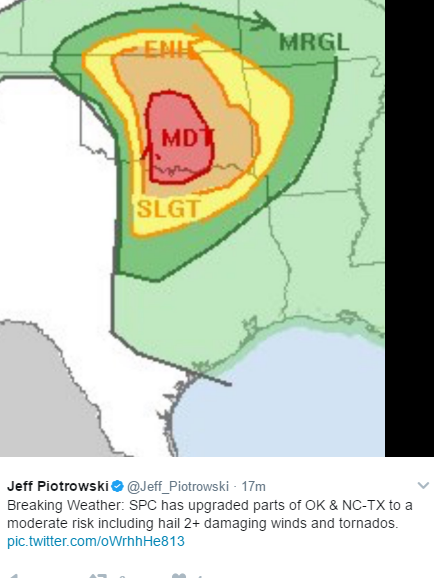
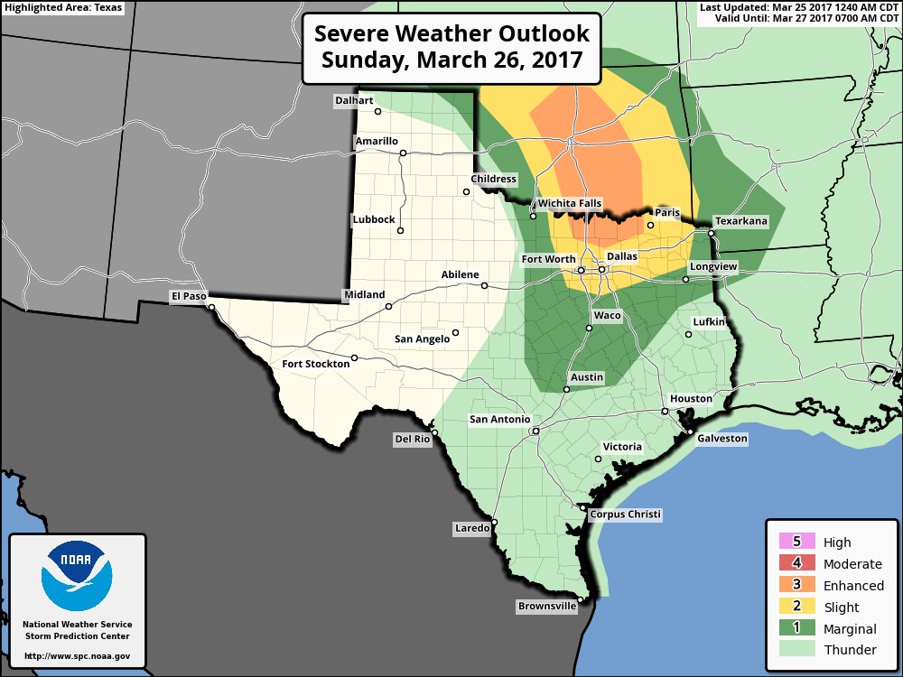
Interesting setup for tomorrow afternoon across the northern burbs of DFW

0 likes
Winter time post are almost exclusively focused on the DFW area.
- bubba hotep
- S2K Supporter

- Posts: 5456
- Joined: Wed Dec 28, 2016 1:00 am
- Location: Collin County Texas
Re: Texas Spring 2017
The 12z Euro looks to try and break the cap for areas across N. Texas tomorrow but it still looks like the highest risk will be up closer to the Red River and into Central OK. That said, better moisture quality looks to possibly stay south of that area? It is at least something to track tomorrow and it would be cool to get a picturesque supercell across N. Texas tomorrow.
0 likes
Winter time post are almost exclusively focused on the DFW area.
- bubba hotep
- S2K Supporter

- Posts: 5456
- Joined: Wed Dec 28, 2016 1:00 am
- Location: Collin County Texas
Re: Texas Spring 2017
Pretty much all signs point to storms firing along the dryline tomorrow. However, it is questionable if those cells can survive off the line? Denton and Collin counties could be under the gun tomorrow afternoon.
0 likes
Winter time post are almost exclusively focused on the DFW area.
-
Brent
- S2K Supporter

- Posts: 37091
- Age: 35
- Joined: Sun May 16, 2004 10:30 pm
- Location: Tulsa Oklahoma
- Contact:
Re: Texas Spring 2017
Ntxw wrote:gpsnowman wrote:Normally mid 50's for lows are not that cold for March. Well, not this year. I opened my window before bed and had to shut it in the middle of the night because I got cold. 50's are the new 40's.
I had my windows open and they are still open. Yeah 50s in May is cool, in March shouldn't be but it is. The theme in terms of overall warmth continues as March is now over 8F above normal for DFW. Sitting at 65F avg would be good enough for second warmest March on record behind March 1907.
Lol if March ended today it'd be like a normal April...
The Tuesday/Wednesday heavy rain event is mostly in agreement, at least on the GFS, GFS para, and the CMC with 2-4" in the metro
The Euro for the 2nd run in a row has a major dry area around DFW with a quarter to a half inch in the metro. Kind of weird. It had over 4 inches of rain for many runs in a row.
It appears there will be another widespread rain event next weekend to welcome April at some point.
0 likes
#neversummer
-
WeatherGuesser
- Category 5

- Posts: 2672
- Joined: Tue Jun 29, 2010 6:46 am
Re: Texas Spring 2017
SPC Day 3 Enhanced:
Day 3 Convective Outlook
NWS Storm Prediction Center Norman OK
0206 AM CDT Sun Mar 26 2017
Valid 281200Z - 291200Z
...THERE IS AN ENHANCED RISK OF SEVERE THUNDERSTORMS OVER PARTS OF
WEST-CENTRAL TEXAS...
...THERE IS A SLIGHT RISK OF SEVERE THUNDERSTORMS OVER PARTS OF WEST
TEXAS AND SOUTHWEST OKLAHOMA...
...THERE IS A MARGINAL RISK OF SEVERE THUNDERSTORMS OVER MUCH OF THE
SOUTHERN PLAINS...
...SUMMARY...
Strong to severe storms are forecast for Tuesday over parts of
western and central Texas, and southwest Oklahoma.
The next in a series of strong and progressive upper troughs will
track into the southwest states on Tuesday. By afternoon, model
guidance is consistent that strong mid-level height falls and
rapidly increasing wind fields will develop over much of the
southern High Plains. This will draw Gulf moisture northwestward
and focus a dryline just east of the TX/NM border. Models remain
somewhat inconsistent in the latitude of the upper trough, and the
details of where the surface low and dryline will develop.
Nevertheless, an active round of severe storms is forecast for parts
of this region during the evening hours. Forecast soundings show
steep mid level lapse rates, favorable low level moisture, and
strong low/deep layer shear. These parameters suggest the risk of
very large hail, damaging winds, as well as tornadoes. Therefore
have added an Enhanced risk area where confidence in severe storms
is highest at this time.
..Hart.. 03/26/2017
0 likes
Re: Texas Spring 2017
James Spann tweeted/posted the HRRR STP parameters for today. Looking UP for the Dallas area. I just checked it myself, some PDS indicators are in there as well. Same for Wednesday, but it was the NAM saying PDS.
0 likes
-
aggiecutter
- Category 5

- Posts: 1743
- Joined: Thu Oct 14, 2004 9:22 pm
- Location: Texarkana
- bubba hotep
- S2K Supporter

- Posts: 5456
- Joined: Wed Dec 28, 2016 1:00 am
- Location: Collin County Texas
Re: Texas Spring 2017
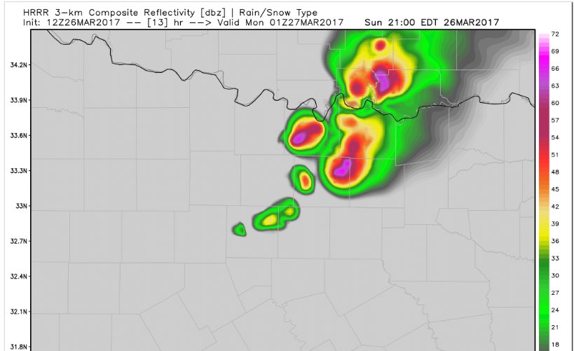
I'm eyeing the far northern DFW burbs up to the Red River:


0 likes
Winter time post are almost exclusively focused on the DFW area.
- bubba hotep
- S2K Supporter

- Posts: 5456
- Joined: Wed Dec 28, 2016 1:00 am
- Location: Collin County Texas
Re: Texas Spring 2017
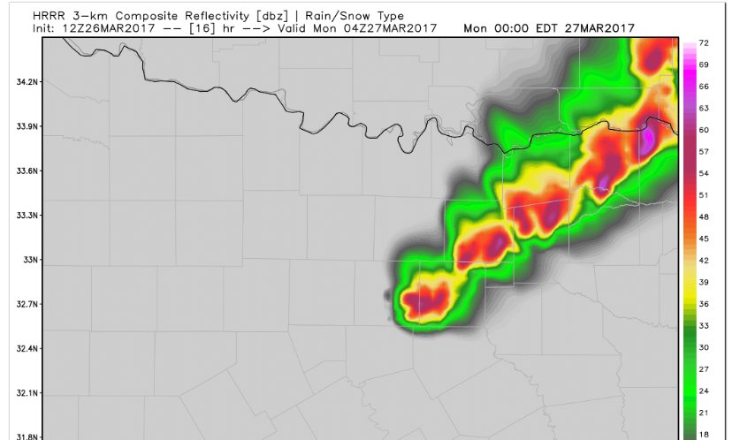
Given the potential parameter space, this could be problematic

0 likes
Winter time post are almost exclusively focused on the DFW area.
Re: Texas Spring 2017
Are we not expecting the CAP to break west of Austin? The STP on the HRRR is out of bounds on the last run.
0 likes
Return to “USA & Caribbean Weather”
Who is online
Users browsing this forum: No registered users and 133 guests


