Florida Weather

U.S. & Caribbean Weather Discussions and Severe Weather Events

Moderator: S2k Moderators

Forum rules

The posts in this forum are NOT official forecast and should not be used as such. They are just the opinion of the poster and may or may not be backed by sound meteorological data. They are NOT endorsed by any professional institution or STORM2K.

Help Support Storm2K
Message
Author
mlfreeman
S2K Supporter
S2K Supporter
Posts: 81
Joined: Sun Feb 18, 2018 11:48 am
Location: Jacksonville, FL

Re: Florida Weather

#12821 Postby mlfreeman » Sun Jun 03, 2018 2:18 pm

northjaxpro wrote:It was a very fierce, wild round of thunderstorms which moved through Northeast Florida late yesterday and early evening.

A very intense line of storms moved E/SE out of South Georgia through the Jax metro area, bringing strong, winds and very heavy rain. I measured a 57 mph wind gust late yesterday afternoon in a severe thunderstorm and picked up2.3 inches. The lightning was intense. I saw on tge news here that there were some homes badly damaged by lightning, including one by fire, and lightning placing a huge hole in a roof in another.


The rainfall last night put my locale just over 11 inches for the week, which includes Alberto's total.

A very wet start for the sumner season indeed.Yeah, no kidding the rainy season is here.

Also, it reached 95 degrees yesterday here, the hottest day so far this season. No doubt that the very hot temps helped contribute to yesterday's severe weather here.


2.3 inches? wow.
The wind didn't weaken but the rain did. I got 1/10th that on the south side of Jax.

In the run up to the storms, I ran out to do one last errand and as I walked into the grocery store, I noticed it felt strangely dry despite the dark clouds on the horizon.
0 likes   

User avatar
northjaxpro
S2K Supporter
S2K Supporter
Posts: 8900
Joined: Mon Sep 27, 2010 11:21 am
Location: Jacksonville, FL

Re: Florida Weather

#12822 Postby northjaxpro » Sun Jun 03, 2018 2:25 pm

mlfreeman wrote:
northjaxpro wrote:It was a very fierce, wild round of thunderstorms which moved through Northeast Florida late yesterday and early evening.

A very intense line of storms moved E/SE out of South Georgia through the Jax metro area, bringing strong, winds and very heavy rain. I measured a 57 mph wind gust late yesterday afternoon in a severe thunderstorm and picked up2.3 inches. The lightning was intense. I saw on tge news here that there were some homes badly damaged by lightning, including one by fire, and lightning placing a huge hole in a roof in another.


The rainfall last night put my locale just over 11 inches for the week, which includes Alberto's total.

A very wet start for the sumner season indeed.Yeah, no kidding the rainy season is here.

Also, it reached 95 degrees yesterday here, the hottest day so far this season. No doubt that the very hot temps helped contribute to yesterday's severe weather here.


2.3 inches? wow.
The wind didn't weaken but the rain did. I got 1/10th that on the south side of Jax.


I had a severe cell dump right over my home locale last evening. I have had heavy downpours nearly every day this past week . Total of over 11 inches since last Sunday. Typical summer weather. It just depends on where you are in many instances.
0 likes   
NEVER, EVER SAY NEVER in the tropics and weather in general, and most importantly, with life itself!!

________________________________________________________________________________________

Fay 2008 Beryl 2012 Debby 2012 Colin 2016 Hermine 2016 Julia 2016 Matthew 2016 Irma 2017 Dorian 2019

User avatar
AdamFirst
S2K Supporter
S2K Supporter
Posts: 2487
Age: 34
Joined: Thu Aug 14, 2008 10:54 am
Location: Port Saint Lucie, FL

Re: Florida Weather

#12823 Postby AdamFirst » Sun Jun 03, 2018 9:20 pm

Welcome to summer, week one. It's roasting out there after two weeks of mild temperatures due to cloud cover. There is still copious amounts of standing water in poor drainage areas and ditches here. It may take a few more days like this to get everything soaked up into the Earth.
1 likes   
Dolphins Marlins Canes Golden Panthers HEAT
Andrew 1992 - Irene 1999 - Frances 2004 - Jeanne 2004 - Wilma 2005 - Fay 2008 - Isaac 2012 - Matthew 2016 - Irma 2017 - Dorian 2019 - Ian 2022 - Nicole 2022

psyclone
S2K Supporter
S2K Supporter
Posts: 4487
Joined: Wed Aug 24, 2005 9:04 pm
Location: palm harbor fl

Re: Florida Weather

#12824 Postby psyclone » Sun Jun 03, 2018 11:59 pm

Deep westerly wind flow off the Gulf has yielded a 1 am observation at st pete Clearwater (KPIE) of 80 with a dewpoint of 80.
1 likes   

User avatar
gatorcane
S2K Supporter
S2K Supporter
Posts: 23499
Age: 46
Joined: Sun Mar 13, 2005 3:54 pm
Location: Boca Raton, FL

Re: Florida Weather

#12825 Postby gatorcane » Mon Jun 04, 2018 3:53 pm

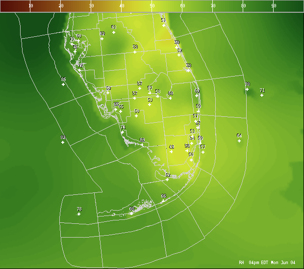
Usually with a west flow like this we would get some good thunderstorm development across metro SE Florida but the past couple of days there has been a lack of that activity due to some dry air around. It actually feels and more like mid May out there just before the rainy season starts (even though the rainy season has officially already started). Indeed looking at the latest observations this afternoon across Florida, the RH values seem on the low side for this time of year. Ironic that May may very likely go down as a rainier month than June for us here in South Florida.

Image
0 likes   

User avatar
TheStormExpert
Category 5
Category 5
Posts: 8487
Age: 30
Joined: Wed Feb 16, 2011 5:38 pm
Location: Palm Beach Gardens, FL

Re: Florida Weather

#12826 Postby TheStormExpert » Mon Jun 04, 2018 4:46 pm

:uarrow: Also compared to the last several summers the Bermuda High is nonexistent so far. Looks like we are back to (dare I say it) that "Semi-Permanent" East Coast Trough that is known to steer hurricanes out to sea away from the U.S. Of course with the nearly record cold MDR I'm even wondering if there will even be anything of significance to have to worry about from the east this hurricane season. Our problems may be from the south and west in the Western Caribbean which in a setup like this wouldn't be good. Just think of Wilma.
0 likes   
The following post is NOT an official forecast and should not be used as such. It is just the opinion of the poster and may or may not be backed by sound meteorological data. It is NOT endorsed by storm2k.org.

User avatar
AdamFirst
S2K Supporter
S2K Supporter
Posts: 2487
Age: 34
Joined: Thu Aug 14, 2008 10:54 am
Location: Port Saint Lucie, FL

Re: Florida Weather

#12827 Postby AdamFirst » Mon Jun 04, 2018 5:49 pm

Extremely prominent outflow boundary on Melbourne radar as coastal thunderstorms develop. SPC placed a marginal risk for severe weather for the East Central Florida coastline earlier in the afternoon.

Image
0 likes   
Dolphins Marlins Canes Golden Panthers HEAT
Andrew 1992 - Irene 1999 - Frances 2004 - Jeanne 2004 - Wilma 2005 - Fay 2008 - Isaac 2012 - Matthew 2016 - Irma 2017 - Dorian 2019 - Ian 2022 - Nicole 2022

User avatar
gatorcane
S2K Supporter
S2K Supporter
Posts: 23499
Age: 46
Joined: Sun Mar 13, 2005 3:54 pm
Location: Boca Raton, FL

Re: Florida Weather

#12828 Postby gatorcane » Mon Jun 04, 2018 8:39 pm

Impressive cell over West Palm Beach metro and northern Palm Peach County...curious what kind of conditions the storm brought from our posters in the area such as TheStormExpert?
1 likes   

Patrick99
Category 5
Category 5
Posts: 1752
Joined: Mon May 24, 2004 3:43 pm
Location: Miami, FL

Re: Florida Weather

#12829 Postby Patrick99 » Tue Jun 05, 2018 8:31 am

gatorcane wrote:Usually with a west flow like this we would get some good thunderstorm development across metro SE Florida but the past couple of days there has been a lack of that activity due to some dry air around. It actually feels and more like mid May out there just before the rainy season starts (even though the rainy season has officially already started). Indeed looking at the latest observations this afternoon across Florida, the RH values seem on the low side for this time of year. Ironic that May may very likely go down as a rainier month than June for us here in South Florida.

Image


Yeah, I don't understand why a light W breeze has to led to such little storm activity. When that happens in June generally, all hell breaks loose over here on the east coast. Although yesterday, I was up in Broward, and around 6PM, the cap did manage to break and some storms with impressive lightning did pop up. I don't think Miami-Dade got anything, though.
0 likes   

User avatar
TheStormExpert
Category 5
Category 5
Posts: 8487
Age: 30
Joined: Wed Feb 16, 2011 5:38 pm
Location: Palm Beach Gardens, FL

Re: Florida Weather

#12830 Postby TheStormExpert » Tue Jun 05, 2018 11:36 am

gatorcane wrote:Impressive cell over West Palm Beach metro and northern Palm Peach County...curious what kind of conditions the storm brought from our posters in the area such as TheStormExpert?

Fell asleep around 9 just when things were ramping up! :sleeping:

Managed to pick up a good quarter of an inch with my backyard rain gauge reading .26 of an inch. Thunder and lightning started just before dusk and likely went on for awhile as there looked to be a good lightning show setting up overhead around 9pm.

With all that daytime heating thanks to the SW flow it would’ve surprised me if no storms developed.
0 likes   
The following post is NOT an official forecast and should not be used as such. It is just the opinion of the poster and may or may not be backed by sound meteorological data. It is NOT endorsed by storm2k.org.

User avatar
Taffy
Tropical Storm
Tropical Storm
Posts: 221
Joined: Wed Sep 08, 2004 7:05 am
Location: Lehigh Acres/SW Florida

Re: Florida Weather

#12831 Postby Taffy » Tue Jun 05, 2018 2:26 pm

Day 4 of no rain over Lehigh Acres in Lee County.
I am growing concerned. The temperatures are deep into the 90s and indexes over 100*.
0 likes   
Taffy-SW Florida

User avatar
gatorcane
S2K Supporter
S2K Supporter
Posts: 23499
Age: 46
Joined: Sun Mar 13, 2005 3:54 pm
Location: Boca Raton, FL

Re: Florida Weather

#12832 Postby gatorcane » Tue Jun 05, 2018 2:38 pm

TheStormExpert wrote:
gatorcane wrote:Impressive cell over West Palm Beach metro and northern Palm Peach County...curious what kind of conditions the storm brought from our posters in the area such as TheStormExpert?

Fell asleep around 9 just when things were ramping up! :sleeping:

Managed to pick up a good quarter of an inch with my backyard rain gauge reading .26 of an inch. Thunder and lightning started just before dusk and likely went on for awhile as there looked to be a good lightning show setting up overhead around 9pm.

With all that daytime heating thanks to the SW flow it would’ve surprised me if no storms developed.


It's definitely a dry and hot SW flow, doesn't feel like typical summer-time SE Florida weather. NWS Miami discussion suggests there could be some good cells developing today. I see some off to the west, but not sure if we get a seabreeze today or not to help fire off convection.
0 likes   

User avatar
TheStormExpert
Category 5
Category 5
Posts: 8487
Age: 30
Joined: Wed Feb 16, 2011 5:38 pm
Location: Palm Beach Gardens, FL

Re: Florida Weather

#12833 Postby TheStormExpert » Tue Jun 05, 2018 2:51 pm

Storms firing now in NE Palm Beach County and especially along the Treasure Coast.

Image
0 likes   
The following post is NOT an official forecast and should not be used as such. It is just the opinion of the poster and may or may not be backed by sound meteorological data. It is NOT endorsed by storm2k.org.

Patrick99
Category 5
Category 5
Posts: 1752
Joined: Mon May 24, 2004 3:43 pm
Location: Miami, FL

Re: Florida Weather

#12834 Postby Patrick99 » Wed Jun 06, 2018 1:58 pm

I don't understand why the east coast seabreeze is having a hard time getting going. When there's an overwhelming W wind of 15-20mph, I understand that kind of flow would shut the sea breeze down completely...but I just spent an hour outside. There is only a light breeze from the west. Given the high temperature differential between ocean and land, I would expect the seabreeze circulation to make more of a dent?

Then again, I feel like we haven't had an ongoing "normal afternoon thunderstorm" pattern around here in over a decade, so I guess this kind of thing is the new normal.
0 likes   

User avatar
gatorcane
S2K Supporter
S2K Supporter
Posts: 23499
Age: 46
Joined: Sun Mar 13, 2005 3:54 pm
Location: Boca Raton, FL

Re: Florida Weather

#12835 Postby gatorcane » Wed Jun 06, 2018 4:36 pm

Here in coastal SE Palm Beach County, the seabreeze has managed to develop (albeit usually around 3-4 in the afternoon which is later than normal) each day of this anomalously strong west wind pattern. Same thing for Broward county as well looking at Pompano Beach Airpark observations. Did get some nice cells to develop today along the seabreeze. Yesterday we just missed the storms in Boca (they were to our south and north) but got decent rainfall today.
0 likes   

User avatar
StormingB81
S2K Supporter
S2K Supporter
Posts: 5676
Age: 42
Joined: Thu Aug 27, 2009 1:45 am
Location: Rockledge, Florida

Re: Florida Weather

#12836 Postby StormingB81 » Wed Jun 06, 2018 5:07 pm

Last 2 days had some good storms in Cape Canaveral
1 likes   

User avatar
Taffy
Tropical Storm
Tropical Storm
Posts: 221
Joined: Wed Sep 08, 2004 7:05 am
Location: Lehigh Acres/SW Florida

Re: Florida Weather

#12837 Postby Taffy » Thu Jun 07, 2018 9:17 am

Waking up to day 6. No appreciable rain in Lehigh over my neighborhood. Mother Nature did try for the first time in 5 day over the whole county. So there is some hope here on day 6. Watching what may be coming next week and thinking I should be careful what I wish for. I hope it rains today, and least.

Summer has not been what it used to be in at least the last 10 years.
0 likes   
Taffy-SW Florida

psyclone
S2K Supporter
S2K Supporter
Posts: 4487
Joined: Wed Aug 24, 2005 9:04 pm
Location: palm harbor fl

Re: Florida Weather

#12838 Postby psyclone » Thu Jun 07, 2018 10:25 am

We have yet to enter a typical Summer pattern which is characterized by a light east southeast flow across the state, morning showers on the east coast, seabreeze development in the afternoon and big storms zippering up the west coast from Naples to the nature coast late day moving out over the Gulf. to me that is a classic summer pattern. we're still stuck in a westerly flow. It will get going at some point...it always does.
1 likes   

User avatar
NotSparta
Professional-Met
Professional-Met
Posts: 1645
Age: 22
Joined: Fri Aug 18, 2017 8:24 am
Location: Naples, FL
Contact:

Re: Florida Weather

#12839 Postby NotSparta » Thu Jun 07, 2018 10:35 am

psyclone wrote:We have yet to enter a typical Summer pattern which is characterized by a light east southeast flow across the state, morning showers on the east coast, seabreeze development in the afternoon and big storms zippering up the west coast from Naples to the nature coast late day moving out over the Gulf. to me that is a classic summer pattern. we're still stuck in a westerly flow. It will get going at some point...it always does.


Seems that the rain in May was like a false beginning of the wet season, kind of like the false springs here
1 likes   
This post was probably an opinion of mine, and in no way is official. Please refer to http://www.hurricanes.gov for official tropical analysis and advisories.

My website, with lots of tropical wx graphics, including satellite and recon: http://cyclonicwx.com

psyclone
S2K Supporter
S2K Supporter
Posts: 4487
Joined: Wed Aug 24, 2005 9:04 pm
Location: palm harbor fl

Re: Florida Weather

#12840 Postby psyclone » Thu Jun 07, 2018 11:15 am

NotSparta wrote:
psyclone wrote:We have yet to enter a typical Summer pattern which is characterized by a light east southeast flow across the state, morning showers on the east coast, seabreeze development in the afternoon and big storms zippering up the west coast from Naples to the nature coast late day moving out over the Gulf. to me that is a classic summer pattern. we're still stuck in a westerly flow. It will get going at some point...it always does.


Seems that the rain in May was like a false beginning of the wet season, kind of like the false springs here


The rain wasn't traditional rainy season seabreeze action...in fact it probably helped to delay it by holding water temps down. we need a Bermuda high and warm waters not just at the shore but offshore as well. So what we need is some dry weather to heat the waters up...since we were denied that during our cloudy and wet May. It was an odd Spring with freakish heat in February followed by lots of dry cool invasions in March and April and then exceptionally wet in May. But at least we enjoyed some amazing weather this year. March was cooler than February and now we stand a decent chance of having a drier June than May.
1 likes   


Return to “USA & Caribbean Weather”

Who is online

Users browsing this forum: Cpv17 and 32 guests