
East Atlantic Tropical Wave
Moderator: S2k Moderators
Forum rules

The posts in this forum are NOT official forecasts and should not be used as such. They are just the opinion of the poster and may or may not be backed by sound meteorological data. They are NOT endorsed by any professional institution or STORM2K. For official information, please refer to products from the National Hurricane Center and National Weather Service.
-
floridasun78
- Category 5

- Posts: 3755
- Joined: Sun May 17, 2009 10:16 pm
- Location: miami fl
East Atlantic Tropical Wave
that way look like have spin with it but i expect Africa duct and shear will do it as we seen other wave coming off Africa this season
2 likes
-
TheStormExpert

- Category 5
- Posts: 8487
- Age: 30
- Joined: Wed Feb 16, 2011 5:38 pm
- Location: Palm Beach Gardens, FL
Re: Wave coming off Africa
Looks impressive, for now that is. 
2 likes
The following post is NOT an official forecast and should not be used as such. It is just the opinion of the poster and may or may not be backed by sound meteorological data. It is NOT endorsed by storm2k.org.
-
floridasun78
- Category 5
- Posts: 3755
- Joined: Sun May 17, 2009 10:16 pm
- Location: miami fl
Re: Wave coming off Africa
if look loop you see have good spin to it https://www.tropicaltidbits.com/sat/satlooper.php?region=eatl&product=irTheStormExpert wrote:Looks impressive, for now that is.
0 likes
-
AJC3

- Admin

- Posts: 3873
- Age: 60
- Joined: Tue Aug 31, 2004 7:04 pm
- Location: West Melbourne, Florida
- Contact:
Re: Wave coming off Africa
Hostile environment...models do nothing with it....this thread will be pretty short.
2 likes
-
NotSparta

- Professional-Met

- Posts: 1649
- Age: 22
- Joined: Fri Aug 18, 2017 8:24 am
- Location: Naples, FL
- Contact:
Re: Wave coming off Africa
Not seeing too much spin, but it's doing nicely w/ keeping & firing convection. Will probably lose that convection pretty soon though

1 likes
This post was probably an opinion of mine, and in no way is official. Please refer to http://www.hurricanes.gov for official tropical analysis and advisories.
My website, with lots of tropical wx graphics, including satellite and recon: http://cyclonicwx.com
My website, with lots of tropical wx graphics, including satellite and recon: http://cyclonicwx.com
-
AutoPenalti
- Category 5
- Posts: 3949
- Age: 27
- Joined: Mon Aug 17, 2015 4:16 pm
- Location: Ft. Lauderdale, Florida
Re: Wave coming off Africa
Not prime time for MDR systems to shine. Won’t last long I believe.
1 likes
The posts in this forum are NOT official forecasts and should not be used as such. They are just the opinion of the poster and may or may not be backed by sound meteorological data. They are NOT endorsed by any professional institution or STORM2K. For official information, please refer to products from the NHC and NWS.
Model Runs Cheat Sheet:
GFS (5:30 AM/PM, 11:30 AM/PM)
HWRF, GFDL, UKMET, NAVGEM (6:30-8:00 AM/PM, 12:30-2:00 AM/PM)
ECMWF (1:45 AM/PM)
TCVN is a weighted averaged

Re: Wave coming off Africa
The CDO is quite impressive tonight, and the early morning visible imagery should prove interesting. Could develop enough to survive the dry air and shear so probably worth watching the model trends.
0 likes
-
NotSparta
- Professional-Met
- Posts: 1649
- Age: 22
- Joined: Fri Aug 18, 2017 8:24 am
- Location: Naples, FL
- Contact:
Re: Wave coming off Africa
Did some analysis on the environment.
The wave has a decent moisture pocket, so the convection can persist. The dry air ahead doesn't appear to be moving much however, which means it could run into that dry air.
https://weather.msfc.nasa.gov/cgi-bin/get-abi?satellite=GOESEastfullDiskband08&lat=10&lon=-20&zoom=1&palette=wv2.pal&quality=100&width=1000&height=1000&type=Animation&numframes=50
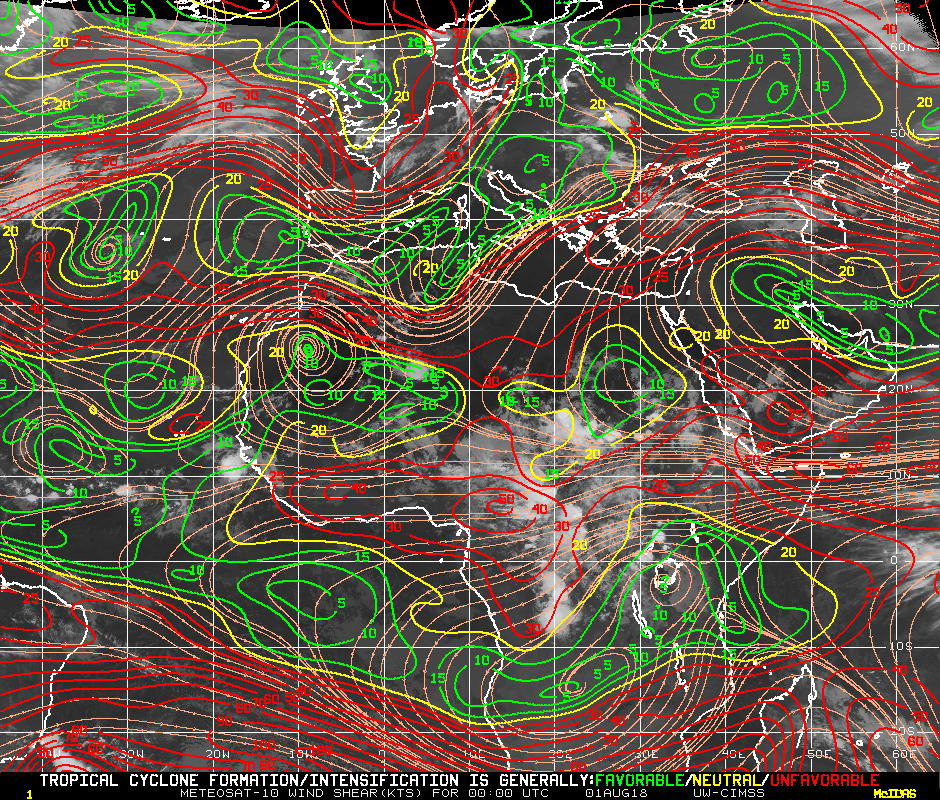
Assuming the wave keeps a westerly course, shear does not seem to be a problem until it nears the Caribbean.
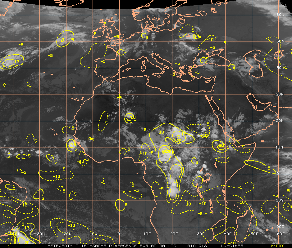
There's a small patch of upper divergence, which is also supporting the convection
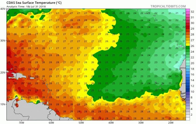
Assuming it does not move much to the north, SSTs are decent. To the north they become marginal
Still, I don't really expect this wave to really do much of anything right now
The wave has a decent moisture pocket, so the convection can persist. The dry air ahead doesn't appear to be moving much however, which means it could run into that dry air.
https://weather.msfc.nasa.gov/cgi-bin/get-abi?satellite=GOESEastfullDiskband08&lat=10&lon=-20&zoom=1&palette=wv2.pal&quality=100&width=1000&height=1000&type=Animation&numframes=50
Assuming the wave keeps a westerly course, shear does not seem to be a problem until it nears the Caribbean.
There's a small patch of upper divergence, which is also supporting the convection
Assuming it does not move much to the north, SSTs are decent. To the north they become marginal
Still, I don't really expect this wave to really do much of anything right now
2 likes
This post was probably an opinion of mine, and in no way is official. Please refer to http://www.hurricanes.gov for official tropical analysis and advisories.
My website, with lots of tropical wx graphics, including satellite and recon: http://cyclonicwx.com
My website, with lots of tropical wx graphics, including satellite and recon: http://cyclonicwx.com


Re: Wave coming off Africa
floridasun78 wrote:if look loop you see have good spin to it https://www.tropicaltidbits.com/sat/satlooper.php?region=eatl&product=irTheStormExpert wrote:Looks impressive, for now that is.
Good eye
0 likes
Personal Forecast Disclaimer:
The posts in this forum are NOT official forecast and should not be used as such. They are just the opinion of the poster and may or may not be backed by sound meteorological data. They are NOT endorsed by any professional institution or storm2k.org. For official information, please refer to the NHC and NWS products.
The posts in this forum are NOT official forecast and should not be used as such. They are just the opinion of the poster and may or may not be backed by sound meteorological data. They are NOT endorsed by any professional institution or storm2k.org. For official information, please refer to the NHC and NWS products.
-
emeraldislenc
- Category 2

- Posts: 524
- Joined: Fri Aug 24, 2012 4:49 pm
- Location: Emerald Isle NC


-
AJC3
- Admin
- Posts: 3873
- Age: 60
- Joined: Tue Aug 31, 2004 7:04 pm
- Location: West Melbourne, Florida
- Contact:
Re: East Atlantic Tropical Wave
Tropical Weather Discussion
NWS National Hurricane Center Miami FL
757 PM EDT Wed Aug 1 2018
...TROPICAL WAVES...
An Atlantic Ocean tropical wave is along 31W from 17N southward,
moving W 10 to 15 knots. Scattered moderate convection is from
08N to 10N between 25W and 32W.
--------------------------------------------------------------------------------------------
Note: at the time this thread was started a little less than 24 hour ago, the small cluster of convection depicted in satellite imagery was located near 18W. However, the axis of the T-wave that was analyzed at the time was a full 5 degrees farther to the west, and its associated convection only extended back to 22W...
--------------------------------------------------------------------------------------------
Tropical Weather Discussion
NWS National Hurricane Center Miami FL
749 PM EDT Tue Jul 31 2018
...TROPICAL WAVES...
A tropical wave is in the E Atlc with axis extending from 08N-18N
along 23W, moving W at 10 kt. The wave is in a low deep layer
wind shear environment, however is being severely affected by a
Saharan Air Layer outbreak as depicted by GOES-16 RGBs and CIRA
LPW imagery. Shallow moisture and middle level diffluence support
scattered showers S of the monsoon trough from 05N-09N between
22W-30W.
--------------------------------------------------------------------------------------------
Whatever perturbation there was embedded in the easterlies that emerged from the COA last night looks like it may have already dampened out into the ITCZ, which is precisely what the global model guidance was predicting to quickly occur about 24-36 hours after the wave came off. In any case, there is absolutely nothing on IR imagery east of 25W now. Since some of this disturbance's vorticity could be merging with the convectively active wave out ahead of it, rather than lock this thread, it will be kept open for the time being.
NWS National Hurricane Center Miami FL
757 PM EDT Wed Aug 1 2018
...TROPICAL WAVES...
An Atlantic Ocean tropical wave is along 31W from 17N southward,
moving W 10 to 15 knots. Scattered moderate convection is from
08N to 10N between 25W and 32W.
--------------------------------------------------------------------------------------------
Note: at the time this thread was started a little less than 24 hour ago, the small cluster of convection depicted in satellite imagery was located near 18W. However, the axis of the T-wave that was analyzed at the time was a full 5 degrees farther to the west, and its associated convection only extended back to 22W...
--------------------------------------------------------------------------------------------
Tropical Weather Discussion
NWS National Hurricane Center Miami FL
749 PM EDT Tue Jul 31 2018
...TROPICAL WAVES...
A tropical wave is in the E Atlc with axis extending from 08N-18N
along 23W, moving W at 10 kt. The wave is in a low deep layer
wind shear environment, however is being severely affected by a
Saharan Air Layer outbreak as depicted by GOES-16 RGBs and CIRA
LPW imagery. Shallow moisture and middle level diffluence support
scattered showers S of the monsoon trough from 05N-09N between
22W-30W.
--------------------------------------------------------------------------------------------
Whatever perturbation there was embedded in the easterlies that emerged from the COA last night looks like it may have already dampened out into the ITCZ, which is precisely what the global model guidance was predicting to quickly occur about 24-36 hours after the wave came off. In any case, there is absolutely nothing on IR imagery east of 25W now. Since some of this disturbance's vorticity could be merging with the convectively active wave out ahead of it, rather than lock this thread, it will be kept open for the time being.
1 likes


Who is online
Users browsing this forum: cheezyWXguy, cycloneye, Hurricanehink and 162 guests