EPAC: JOHN - Post-Tropical

Moderator: S2k Moderators

Message
Author
User avatar
cycloneye
Admin
Admin
Posts: 139019
Age: 67
Joined: Thu Oct 10, 2002 10:54 am
Location: San Juan, Puerto Rico

Re: EPAC: JOHN - Hurricane

#81 Postby cycloneye » Tue Aug 07, 2018 3:50 pm

Hurricane John Discussion Number 9
NWS National Hurricane Center Miami FL EP122018
300 PM MDT Tue Aug 07 2018

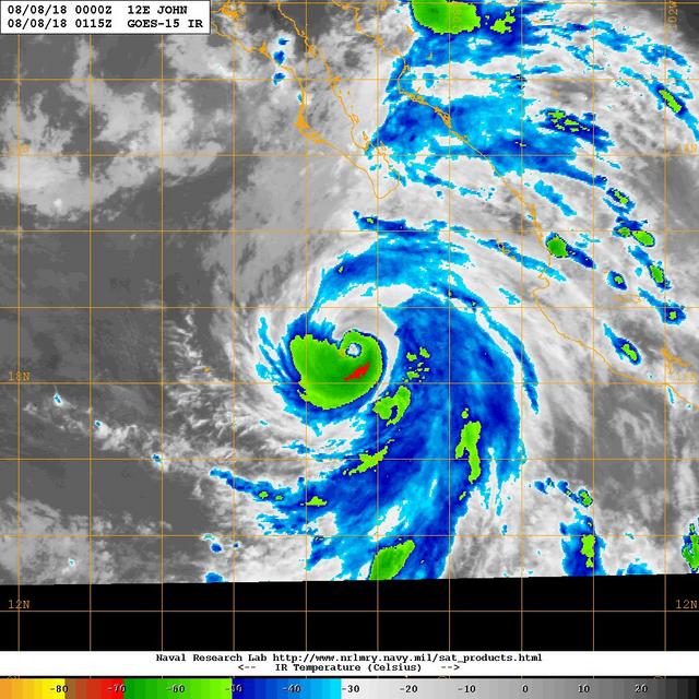
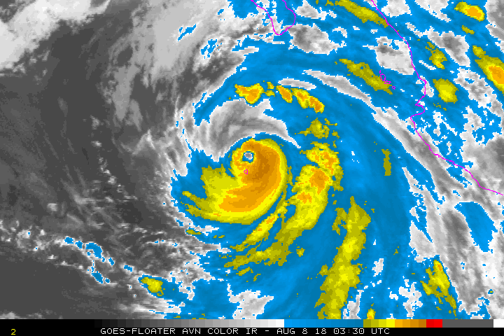
The eye of John has become more distinct in visible and infrared
satellite imagery during the past few hours, however the surrounding
convective clouds tops have warmed, and a 1642 UTC AMSU
microwave overpass indicated that the eyewall was open over the
northwestern portion of the circulation. Although objective Dvorak
T-numbers have increased to T5.6, subjective estimates from TAFB and
SAB are unchanged so the initial intensity is kept at 90 kt. There
is still an opportunity for John to become a major hurricane tonight
or early Wednesday while it remains over warm water and in a low
shear environment. After that time, the hurricane will be moving
over decreasing SSTs and into a less favorable thermodynamic
environment. These conditions should result in steady to rapid
weakening and John is forecast to become a post-tropical cyclone by
day 4 when it is over SSTs of 20-21C. There is significant spread
in the intensity guidance as to how rapid John will spin down. The
NHC forecast is a little higher than the ICON consensus model, but
shows a faster rate of weakening than the statistical guidance.

John is moving northwestward or 320/9 kt. The hurricane should
continue moving northwestward around the western side of a
mid-level ridge over northern Mexico during the next 2-3 days.
After that time, the system should turn westward as it weakens and
comes under the influence of the low-level flow. The track
guidance remains in excellent agreement and the new NHC track is
essentially an update of the previous advisory.

Although the core of John is forecast to remain well offshore of
the Baja California Peninsula, an eastward shift of the forecast
track or an unexpected increase in the size of the outer wind field
of the hurricane could bring tropical-storm-force winds close to
the west coast of the peninsula. In addition, a surge of moisture
around John's outer circulation is expected to bring some locally
heavy rainfall to portions of Baja California Sur during the next
couple of days. Therefore, interests in the southern portion of the
Baja California Peninsula should monitor the progress of John.


FORECAST POSITIONS AND MAX WINDS

INIT 07/2100Z 18.7N 110.5W 90 KT 105 MPH
12H 08/0600Z 19.9N 111.6W 100 KT 115 MPH
24H 08/1800Z 21.5N 113.3W 95 KT 110 MPH
36H 09/0600Z 23.0N 115.2W 80 KT 90 MPH
48H 09/1800Z 24.4N 117.3W 65 KT 75 MPH
72H 10/1800Z 26.6N 121.3W 45 KT 50 MPH
96H 11/1800Z 27.0N 124.7W 35 KT 40 MPH...POST-TROPICAL
120H 12/1800Z 27.0N 127.3W 25 KT 30 MPH...POST-TROP/REMNT LOW

$$
Forecaster Brown
0 likes   
Visit the Caribbean-Central America Weather Thread where you can find at first post web cams,radars
and observations from Caribbean basin members Click Here

User avatar
Kingarabian
S2K Supporter
S2K Supporter
Posts: 15432
Joined: Sat Aug 08, 2009 3:06 am
Location: Honolulu, Hawaii

Re: EPAC: JOHN - Hurricane

#82 Postby Kingarabian » Tue Aug 07, 2018 4:57 pm

Eye clearing out again:

Image
5 likes   
RIP Kobe Bryant

hurricanes1234
Category 5
Category 5
Posts: 2903
Joined: Sat Jul 28, 2012 6:19 pm
Location: Trinidad and Tobago

Re: EPAC: JOHN - Hurricane

#83 Postby hurricanes1234 » Tue Aug 07, 2018 4:59 pm

Doesn't have much more time.
0 likes   
PLEASE NOTE: With the exception of information from weather agencies that I may copy and paste here, my posts will NEVER be official, since I am NOT a meteorologist. They are solely my amateur opinion, and may or may not be accurate. Therefore, please DO NOT use them as official details, particularly when making important decisions. Thank you.

User avatar
Yellow Evan
Professional-Met
Professional-Met
Posts: 15951
Age: 25
Joined: Fri Jul 15, 2011 12:48 pm
Location: Henderson, Nevada/Honolulu, HI
Contact:

Re: EPAC: JOHN - Hurricane

#84 Postby Yellow Evan » Tue Aug 07, 2018 5:34 pm

hurricanes1234 wrote:Doesn't have much more time.


It has about 18 hours.
0 likes   

User avatar
Cyclenall
Category 5
Category 5
Posts: 6627
Joined: Thu Jun 08, 2006 10:01 pm
Location: Ontario, Canada

Re: EPAC: JOHN - Hurricane

#85 Postby Cyclenall » Tue Aug 07, 2018 5:42 pm

Kingarabian wrote:Eye clearing out again:

John has a gaping dry slot to the east of the eye that is the same temp as the eye itself (just about!). Warming cloud tops, ragged convection, poor eyewall, lobsided. Sickly hurricanes like this are junk.

Kingarabian wrote:Still has work to do:

*Image*

The work will remain unfinished with John sucking in all that dry air. Has a bad structure which diminishes its chances of becoming a strong storm. The next benchmark of mediocrity for loose John is to remain at 90 knots until weakening starts...or funnier yet just start weakening now. Tonight's burst of deep convection wrapping will be his last, 25% chance shot at becoming a major.
1 likes   

User avatar
Cyclenall
Category 5
Category 5
Posts: 6627
Joined: Thu Jun 08, 2006 10:01 pm
Location: Ontario, Canada

Re: EPAC: JOHN - Hurricane

#86 Postby Cyclenall » Tue Aug 07, 2018 7:38 pm

There is an extremely tiny speck of -70ºC cloud top to the SW of John's eye/Soccoro Island in the 2330z frame and on the 15 min after frame. Is that tonight's start burst or a false one? The answer: false alarm as the 0z frame shows no area of -70ºC on pathetic John (except a tiny speck on his skirt near the bottom rainband). I can't wait to see how it'll look after that large dry air pocket wraps into the eye to the west.
0 likes   

User avatar
galaxy401
Category 5
Category 5
Posts: 2298
Age: 28
Joined: Sat Aug 25, 2012 9:04 pm
Location: Casa Grande, Arizona

Re: EPAC: JOHN - Hurricane

#87 Postby galaxy401 » Tue Aug 07, 2018 9:00 pm

Cyclenall wrote:There is an extremely tiny speck of -70ºC cloud top to the SW of John's eye/Soccoro Island in the 2330z frame and on the 15 min after frame. Is that tonight's start burst or a false one? The answer: false alarm as the 0z frame shows no area of -70ºC on pathetic John (except a tiny speck on his skirt near the bottom rainband). I can't wait to see how it'll look after that large dry air pocket wraps into the eye to the west.


You seem to be taking this hurricane way too seriously for just a fish (mostly) storm. What were you expecting, a category 5?
0 likes   
Got my eyes on moving right into Hurricane Alley: Florida.

User avatar
cycloneye
Admin
Admin
Posts: 139019
Age: 67
Joined: Thu Oct 10, 2002 10:54 am
Location: San Juan, Puerto Rico

Re: EPAC: JOHN - Hurricane

#88 Postby cycloneye » Tue Aug 07, 2018 9:45 pm

Hurricane John Discussion Number 10
NWS National Hurricane Center Miami FL EP122018
900 PM MDT Tue Aug 07 2018

The eye of John passed a short distance east of Socorro Island a
few hours ago, and it is estimated that the radius of maximum winds
narrowly missed the island. An automated station at Socorro
recorded a wind gust to 70 kt at 2300 UTC. Although John's inner
core convection has weakened somewhat, Dvorak Current Intensity
numbers from TAFB and SAB still support an intensity of 90 kt for
this advisory. Although John should remain over warm waters for
the next day or so, the deterioration of its convection suggests it
is now in a somewhat less favorable atmospheric environment, so no
further strengthening is expected. The official intensity forecast
is somewhat above the model consensus for the first 1-2 days and
near the consensus thereafter.

The initial motion estimate remains northwestward or 315/9 kt. The
hurricane should continue to move northwestward along the
southwestern side of a mid-tropospheric ridge for the next couple of
days. Later, the weakening cyclone is likely to turn to the left
and eventually move westward following the low-level flow. The new
official forecast is in close agreement with the previous one and
much of the track model guidance, which remains in good agreement.

Although the core of John is forecast to remain well offshore of
the Baja California Peninsula, an eastward shift of the forecast
track or an unexpected increase in the size of the outer wind field
of the hurricane could bring tropical-storm-force winds close to
the west coast of the peninsula. In addition, a surge of moisture
around John's outer circulation is expected to bring some locally
heavy rainfall to portions of Baja California Sur during the next
couple of days. Therefore, interests in the southern portion of the
Baja California Peninsula should monitor the progress of John.


FORECAST POSITIONS AND MAX WINDS

INIT 08/0300Z 19.2N 111.1W 90 KT 105 MPH
12H 08/1200Z 20.4N 112.3W 90 KT 105 MPH
24H 09/0000Z 22.0N 114.0W 90 KT 105 MPH
36H 09/1200Z 23.5N 116.0W 80 KT 90 MPH
48H 10/0000Z 24.9N 118.1W 60 KT 70 MPH
72H 11/0000Z 26.6N 122.0W 40 KT 45 MPH
96H 12/0000Z 27.0N 125.4W 30 KT 35 MPH...POST-TROP/REMNT LOW
120H 13/0000Z 27.0N 127.5W 20 KT 25 MPH...POST-TROP/REMNT LOW

$$
Forecaster Pasch
0 likes   
Visit the Caribbean-Central America Weather Thread where you can find at first post web cams,radars
and observations from Caribbean basin members Click Here

User avatar
Yellow Evan
Professional-Met
Professional-Met
Posts: 15951
Age: 25
Joined: Fri Jul 15, 2011 12:48 pm
Location: Henderson, Nevada/Honolulu, HI
Contact:

Re: EPAC: JOHN - Hurricane

#89 Postby Yellow Evan » Tue Aug 07, 2018 9:46 pm

This is going backwards not forwards.
3 likes   

hurricanes1234
Category 5
Category 5
Posts: 2903
Joined: Sat Jul 28, 2012 6:19 pm
Location: Trinidad and Tobago

Re: EPAC: JOHN - Hurricane

#90 Postby hurricanes1234 » Tue Aug 07, 2018 10:12 pm

Yellow Evan wrote:This is going backwards not forwards.


Agreed, I think it's peaked. Reminds me of Hilary last year in a way (and it's in a similarish spot too).
2 likes   
PLEASE NOTE: With the exception of information from weather agencies that I may copy and paste here, my posts will NEVER be official, since I am NOT a meteorologist. They are solely my amateur opinion, and may or may not be accurate. Therefore, please DO NOT use them as official details, particularly when making important decisions. Thank you.

User avatar
Kingarabian
S2K Supporter
S2K Supporter
Posts: 15432
Joined: Sat Aug 08, 2009 3:06 am
Location: Honolulu, Hawaii

Re: EPAC: JOHN - Hurricane

#91 Postby Kingarabian » Tue Aug 07, 2018 11:20 pm

hurricanes1234 wrote:
Yellow Evan wrote:This is going backwards not forwards.


Agreed, I think it's peaked. Reminds me of Hilary last year in a way (and it's in a similarish spot too).

Fabio too.
1 likes   
RIP Kobe Bryant

User avatar
Yellow Evan
Professional-Met
Professional-Met
Posts: 15951
Age: 25
Joined: Fri Jul 15, 2011 12:48 pm
Location: Henderson, Nevada/Honolulu, HI
Contact:

Re: EPAC: JOHN - Hurricane

#92 Postby Yellow Evan » Tue Aug 07, 2018 11:27 pm

Okay we have an actual LG ring now. So at least I smell some improvement though strucutre is vulnerable to dry air for sure unless this becomes more symmetrical. Has 12 hours left to become a major which is not likely but not impossible.
1 likes   

User avatar
Cyclenall
Category 5
Category 5
Posts: 6627
Joined: Thu Jun 08, 2006 10:01 pm
Location: Ontario, Canada

Re: EPAC: JOHN - Hurricane

#93 Postby Cyclenall » Tue Aug 07, 2018 11:52 pm

Image

Image

Image

The deep convective burst needed never came tonight. The width of the west part of his eyewall ring is smaller than the eye width. Its so fragile and looks ready to be broken into by the dry air. John's size and Ileana ended up doing him in.
2 likes   

User avatar
Kingarabian
S2K Supporter
S2K Supporter
Posts: 15432
Joined: Sat Aug 08, 2009 3:06 am
Location: Honolulu, Hawaii

Re: EPAC: JOHN - Hurricane

#94 Postby Kingarabian » Wed Aug 08, 2018 12:00 am

We now know to not believe the models for systems like John, Fabio, and Hilary.
3 likes   
RIP Kobe Bryant

User avatar
Yellow Evan
Professional-Met
Professional-Met
Posts: 15951
Age: 25
Joined: Fri Jul 15, 2011 12:48 pm
Location: Henderson, Nevada/Honolulu, HI
Contact:

Re: EPAC: JOHN - Hurricane

#95 Postby Yellow Evan » Wed Aug 08, 2018 12:07 am

Kingarabian wrote:We now know to not believe the models for systems like John, Fabio, and Hilary.


All 3 looked like solid bets to deepen and were smooth sailing till 80 knots. None of those 3 encountered the usual leveling off we sometimes see at strong TS/weak Cat 1.
1 likes   

User avatar
Yellow Evan
Professional-Met
Professional-Met
Posts: 15951
Age: 25
Joined: Fri Jul 15, 2011 12:48 pm
Location: Henderson, Nevada/Honolulu, HI
Contact:

Re: EPAC: JOHN - Hurricane

#96 Postby Yellow Evan » Wed Aug 08, 2018 12:48 am

Surface obs from Soccoro Island:

08/08/2018 01:00 294 287 82.30 111.10 25.0 89 971.4 0.0
08/08/2018 01:15 281 267 82.80 106.80 24.9 90 972.6 0.0
08/08/2018 01:30 272 268 89.10 117.90 24.8 91 973.2 0.0
08/08/2018 01:45 269 271 84.10 114.20 24.9 90 974.6 0.0
08/08/2018 02:00 266 271 84.20 129.40 25.0 89 976.7 0.0
08/08/2018 02:15 261 258 82.80 115.60 25.1 89 978.9 0.0
08/08/2018 02:30 256 257 89.40 115.30 25.0 90 980.5 0.0
08/08/2018 02:45 253 260 77.40 103.40 25.0 90 982.1 0.0
08/08/2018 03:00 250 250 70.30 101.60 25.0 90 983.5 0.0
08/08/2018 03:15 247 247 72.90 116.50 25.0 91 984.8 0.0
08/08/2018 03:30 246 244 64.80 90.20 25.2 91 986.3 0.0
08/08/2018 03:45 242 240 62.00 97.90 25.4 90 987.7 0.0


89 knots 10 min sustained with 130 knot gusts. Pressure 971.4mbar. This may have been underestimated.
2 likes   

CrazyC83
Professional-Met
Professional-Met
Posts: 33393
Joined: Tue Mar 07, 2006 11:57 pm
Location: Deep South, for the first time!

Re: EPAC: JOHN - Hurricane

#97 Postby CrazyC83 » Wed Aug 08, 2018 1:37 am

Yellow Evan wrote:Surface obs from Soccoro Island:

08/08/2018 01:00 294 287 82.30 111.10 25.0 89 971.4 0.0
08/08/2018 01:15 281 267 82.80 106.80 24.9 90 972.6 0.0
08/08/2018 01:30 272 268 89.10 117.90 24.8 91 973.2 0.0
08/08/2018 01:45 269 271 84.10 114.20 24.9 90 974.6 0.0
08/08/2018 02:00 266 271 84.20 129.40 25.0 89 976.7 0.0
08/08/2018 02:15 261 258 82.80 115.60 25.1 89 978.9 0.0
08/08/2018 02:30 256 257 89.40 115.30 25.0 90 980.5 0.0
08/08/2018 02:45 253 260 77.40 103.40 25.0 90 982.1 0.0
08/08/2018 03:00 250 250 70.30 101.60 25.0 90 983.5 0.0
08/08/2018 03:15 247 247 72.90 116.50 25.0 91 984.8 0.0
08/08/2018 03:30 246 244 64.80 90.20 25.2 91 986.3 0.0
08/08/2018 03:45 242 240 62.00 97.90 25.4 90 987.7 0.0


89 knots 10 min sustained with 130 knot gusts. Pressure 971.4mbar. This may have been underestimated.


That would support an intensity of 100 kt with a pressure of 961 mb, assuming that was in the RMW.
1 likes   

User avatar
Yellow Evan
Professional-Met
Professional-Met
Posts: 15951
Age: 25
Joined: Fri Jul 15, 2011 12:48 pm
Location: Henderson, Nevada/Honolulu, HI
Contact:

Re: EPAC: JOHN - Hurricane

#98 Postby Yellow Evan » Wed Aug 08, 2018 1:45 am

CrazyC83 wrote:
Yellow Evan wrote:Surface obs from Soccoro Island:

08/08/2018 01:00 294 287 82.30 111.10 25.0 89 971.4 0.0
08/08/2018 01:15 281 267 82.80 106.80 24.9 90 972.6 0.0
08/08/2018 01:30 272 268 89.10 117.90 24.8 91 973.2 0.0
08/08/2018 01:45 269 271 84.10 114.20 24.9 90 974.6 0.0
08/08/2018 02:00 266 271 84.20 129.40 25.0 89 976.7 0.0
08/08/2018 02:15 261 258 82.80 115.60 25.1 89 978.9 0.0
08/08/2018 02:30 256 257 89.40 115.30 25.0 90 980.5 0.0
08/08/2018 02:45 253 260 77.40 103.40 25.0 90 982.1 0.0
08/08/2018 03:00 250 250 70.30 101.60 25.0 90 983.5 0.0
08/08/2018 03:15 247 247 72.90 116.50 25.0 91 984.8 0.0
08/08/2018 03:30 246 244 64.80 90.20 25.2 91 986.3 0.0
08/08/2018 03:45 242 240 62.00 97.90 25.4 90 987.7 0.0


89 knots 10 min sustained with 130 knot gusts. Pressure 971.4mbar. This may have been underestimated.


That would support an intensity of 100 kt with a pressure of 961 mb, assuming that was in the RMW.


Given this was on the east side and that the instrument wasn’t working when it was over the eye for a while, perhaps lower on both counts.
1 likes   

User avatar
Yellow Evan
Professional-Met
Professional-Met
Posts: 15951
Age: 25
Joined: Fri Jul 15, 2011 12:48 pm
Location: Henderson, Nevada/Honolulu, HI
Contact:

Re: EPAC: JOHN - Hurricane

#99 Postby Yellow Evan » Wed Aug 08, 2018 1:47 am

EP, 12, 2018080806, , BEST, 0, 196N, 1112W, 85, 972, HU, 34, NEQ, 100, 100, 60, 90, 1008, 240, 15, 0, 0, E, 0, , 0, 0, JOHN, D, 0, , 0, 0, 0, 0, genesis-num, 019,
EP, 12, 2018080806, , BEST, 0, 196N, 1112W, 85, 972, HU, 50, NEQ, 50, 50, 30, 40, 1008, 240, 15, 0, 0, E, 0, , 0, 0, JOHN, D, 0, , 0, 0, 0, 0, genesis-num, 019,
EP, 12, 2018080806, , BEST, 0, 196N, 1112W, 85, 972, HU, 64, NEQ, 25, 25, 20, 20, 1008, 240, 15, 0, 0, E, 0, , 0, 0, JOHN, D, 0, , 0, 0, 0, 0, genesis-num, 019,
0 likes   

User avatar
Kingarabian
S2K Supporter
S2K Supporter
Posts: 15432
Joined: Sat Aug 08, 2009 3:06 am
Location: Honolulu, Hawaii

Re: EPAC: JOHN - Hurricane

#100 Postby Kingarabian » Wed Aug 08, 2018 1:54 am

I say this an Fabio have strong offseason major hurricane reconsiderations.
0 likes   
RIP Kobe Bryant


Return to “2018”

Who is online

Users browsing this forum: No registered users and 27 guests