Tropical Wave ESE of Lesser Antilles (Is INVEST 99L)
Moderator: S2k Moderators
Forum rules
The posts in this forum are NOT official forecasts and should not be used as such. They are just the opinion of the poster and may or may not be backed by sound meteorological data. They are NOT endorsed by any professional institution or STORM2K. For official information, please refer to products from the National Hurricane Center and National Weather Service.
-
SconnieCane
- Category 4

- Posts: 990
- Joined: Thu Aug 02, 2018 5:29 pm
- Location: Madison, WI
Re: Area Between Africa and Lesser Antilles 10/20
It's at a pretty low latitude. Any thoughts this could try to pull a Harvey? Not suggesting a similar outcome is likely, but in the general sense of develop just enough to get named, open back up into a wave when it hits unfavorable conditions, but hang on just enough to spin back up into a potentially potent homebrew when it reaches bathwater in the Gulf.
New member btw, but guest lurker since last year's incredible Atlantic season. As you can probably tell from my name I live somewhere far removed from any threat of tropical cyclone impacts, but have been fascinated by them since childhood in the '90s after watching the documentaries on Andrew and Hugo along with John Hope's Tropical Updates on TWC.
New member btw, but guest lurker since last year's incredible Atlantic season. As you can probably tell from my name I live somewhere far removed from any threat of tropical cyclone impacts, but have been fascinated by them since childhood in the '90s after watching the documentaries on Andrew and Hugo along with John Hope's Tropical Updates on TWC.
12 likes
- lrak
- S2K Supporter

- Posts: 1770
- Age: 57
- Joined: Thu Jun 21, 2007 2:48 pm
- Location: Corpus Christi, TX
Re: Area Between Africa and Lesser Antilles 10/20
Welcome SconnieCane I love this board. I've learned so much about the weather from these brainiacs 

0 likes
AKA karl
Also
Personal Forecast Disclaimer:
My posts on this forum are NOT official forecast and should not be used as such. My posts are my basic observations and are definitely not backed by any "well some" meteorological knowledge. For official information, please refer to the NHC and NWS products.
Also
Personal Forecast Disclaimer:
My posts on this forum are NOT official forecast and should not be used as such. My posts are my basic observations and are definitely not backed by any "well some" meteorological knowledge. For official information, please refer to the NHC and NWS products.
- gatorcane
- S2K Supporter

- Posts: 23661
- Age: 46
- Joined: Sun Mar 13, 2005 3:54 pm
- Location: Boca Raton, FL
Re: Area Between Africa and Lesser Antilles 10/20
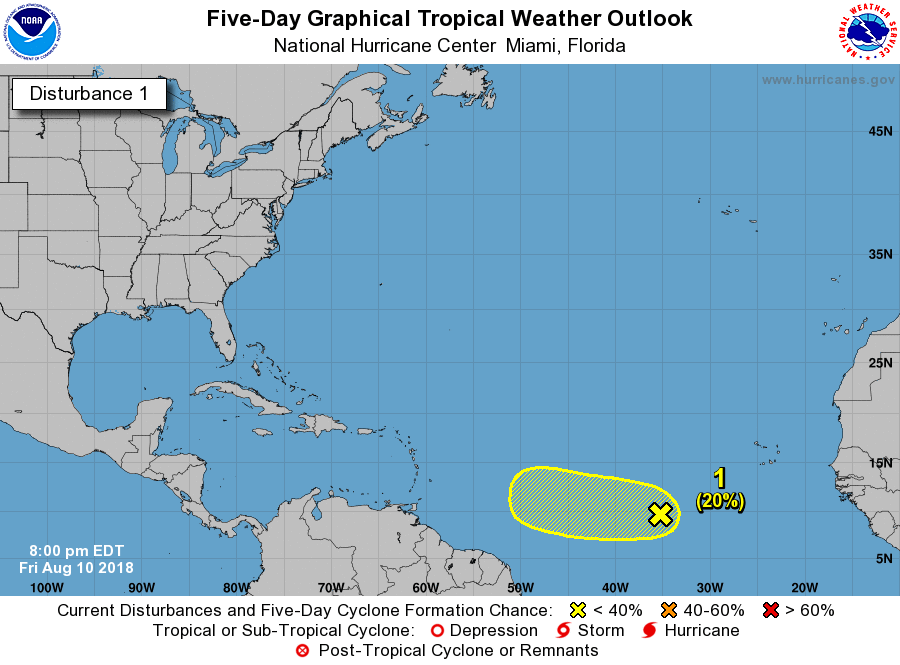
1. A disorganized area of showers and thunderstorms is located about
midway between Africa and the Lesser Antilles. Some gradual
development of this system is possible through early next week as it
moves slowly westward.
* Formation chance through 48 hours...low...10 percent.
* Formation chance through 5 days...low...20 percent.
midway between Africa and the Lesser Antilles. Some gradual
development of this system is possible through early next week as it
moves slowly westward.
* Formation chance through 48 hours...low...10 percent.
* Formation chance through 5 days...low...20 percent.

0 likes
-
AutoPenalti
- Category 5

- Posts: 4023
- Age: 28
- Joined: Mon Aug 17, 2015 4:16 pm
- Location: Ft. Lauderdale, Florida
Re: Area Between Africa and Lesser Antilles 10/20
gatorcane wrote:1. A disorganized area of showers and thunderstorms is located about
midway between Africa and the Lesser Antilles. Some gradual
development of this system is possible through early next week as it
moves slowly westward.
* Formation chance through 48 hours...low...10 percent.
* Formation chance through 5 days...low...20 percent.
[img]https://s8.postimg.cc/m1jpmz6ol/two_atl_5d1.png
Looks like the little "unfavorable upper level winds" snippet was completely removed.
2 likes
The posts in this forum are NOT official forecasts and should not be used as such. They are just the opinion of the poster and may or may not be backed by sound meteorological data. They are NOT endorsed by any professional institution or STORM2K. For official information, please refer to products from the NHC and NWS.
Model Runs Cheat Sheet:
GFS (5:30 AM/PM, 11:30 AM/PM)
HWRF, GFDL, UKMET, NAVGEM (6:30-8:00 AM/PM, 12:30-2:00 AM/PM)
ECMWF (1:45 AM/PM)
TCVN is a weighted averaged
- AnnularCane
- S2K Supporter

- Posts: 2816
- Joined: Thu Jun 08, 2006 9:18 am
- Location: Wytheville, VA
Re: Area Between Africa and Lesser Antilles 10/20
I wonder if they think any unfavorable wind conditions will improve?
0 likes
- gatorcane
- S2K Supporter

- Posts: 23661
- Age: 46
- Joined: Sun Mar 13, 2005 3:54 pm
- Location: Boca Raton, FL
Re: Area Between Africa and Lesser Antilles 10/20
AnnularCane wrote:I wonder if they think any unfavorable wind conditions will improve?
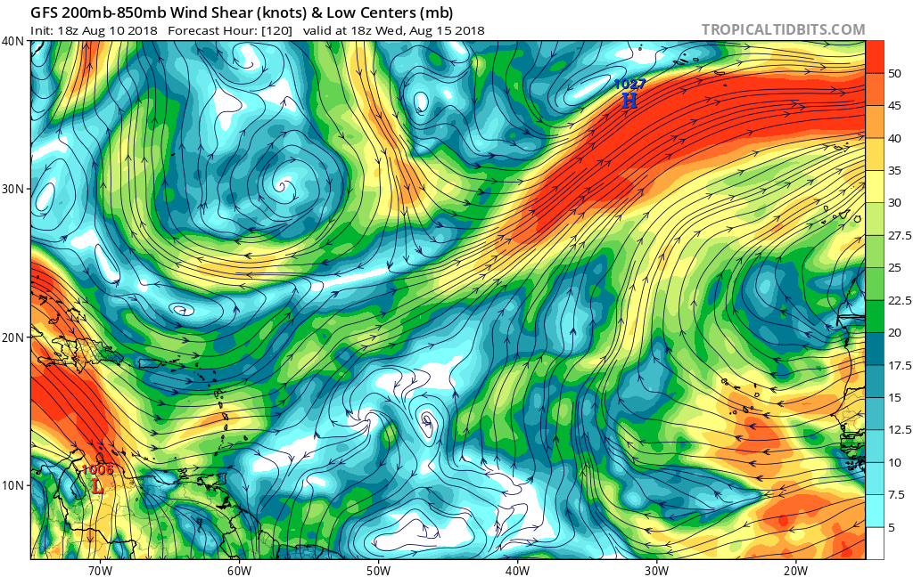
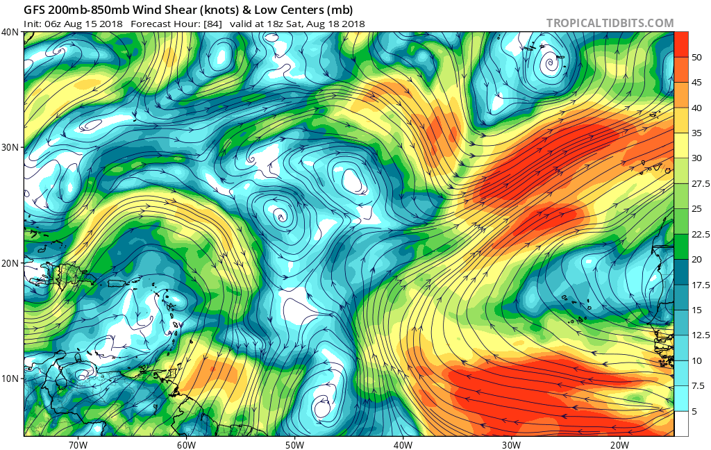
The GFS now shows favorable upper-level winds through the 5 day forecast period. For example here is day 5 and you can see the anticyclonic flow east of the Lesser Antilles. Seems a small anticyclone will build over the system and move west in tandem with it:
2 likes
- NotSparta
- Professional-Met

- Posts: 1668
- Age: 23
- Joined: Fri Aug 18, 2017 8:24 am
- Location: Naples, FL
- Contact:
Re: Area Between Africa and Lesser Antilles 10/20
gatorcane wrote:AnnularCane wrote:I wonder if they think any unfavorable wind conditions will improve?
The GFS now shows favorable upper-level winds through the 5 day forecast period. For example here is day 5 and you can see the anticyclonic flow east of the Lesser Antilles. Seems a small anticyclone will build over the system and move west in tandem with it:
ig]https://s8.postimg.cc/ds7u8zd2t/gfs_shear_eatl_21.png[/img]
Not sure if this would effect the system, but the GFS & GEFS build an anticyclone where the TUTT has been reigning in about a week
https://twitter.com/pppapin/status/1028067437944627201
1 likes
This post was probably an opinion of mine, and in no way is official. Please refer to http://www.hurricanes.gov for official tropical analysis and advisories.
My website, with lots of tropical wx graphics, including satellite and recon: http://cyclonicwx.com
My website, with lots of tropical wx graphics, including satellite and recon: http://cyclonicwx.com
Re: Area Between Africa and Lesser Antilles 10/20
These low latitude systems that feed off the ITCZ are hard to predict till we get a clear circulation center. Should stay south initially as it approaches the eastern periphery of the high so might be a Caribbean runner. Interesting the pro mets are taking notice.
0 likes
- cycloneye
- Admin

- Posts: 142744
- Age: 68
- Joined: Thu Oct 10, 2002 10:54 am
- Location: San Juan, Puerto Rico
Re: Area Between Africa and Lesser Antilles 10/10
1. A disorganized area of showers and thunderstorms is located about
midway between Africa and the Lesser Antilles. Some slight
development of this disturbance is possible during the next day or
two while it remains nearly stationary.
* Formation chance through 48 hours...low...10 percent.
* Formation chance through 5 days...low...10 percent.
midway between Africa and the Lesser Antilles. Some slight
development of this disturbance is possible during the next day or
two while it remains nearly stationary.
* Formation chance through 48 hours...low...10 percent.
* Formation chance through 5 days...low...10 percent.
0 likes
Visit the Caribbean-Central America Weather Thread where you can find at first post web cams,radars
and observations from Caribbean basin members Click Here
and observations from Caribbean basin members Click Here
- cycloneye
- Admin

- Posts: 142744
- Age: 68
- Joined: Thu Oct 10, 2002 10:54 am
- Location: San Juan, Puerto Rico
Re: Area Between Africa and Lesser Antilles 10/10
1. A disorganized area of showers and thunderstorms is located about
midway between Africa and the Lesser Antilles. Some slight
development of this disturbance is possible during the next day or
two while it remains nearly stationary.
* Formation chance through 48 hours...low...10 percent.
* Formation chance through 5 days...low...10 percent.
midway between Africa and the Lesser Antilles. Some slight
development of this disturbance is possible during the next day or
two while it remains nearly stationary.
* Formation chance through 48 hours...low...10 percent.
* Formation chance through 5 days...low...10 percent.
0 likes
Visit the Caribbean-Central America Weather Thread where you can find at first post web cams,radars
and observations from Caribbean basin members Click Here
and observations from Caribbean basin members Click Here
-
AutoPenalti
- Category 5

- Posts: 4023
- Age: 28
- Joined: Mon Aug 17, 2015 4:16 pm
- Location: Ft. Lauderdale, Florida
Re: Area Between Africa and Lesser Antilles 10/10
Interesting that now it’s scaled down to 10% in the next 5 days but does not mention unfavorable conditions.
0 likes
The posts in this forum are NOT official forecasts and should not be used as such. They are just the opinion of the poster and may or may not be backed by sound meteorological data. They are NOT endorsed by any professional institution or STORM2K. For official information, please refer to products from the NHC and NWS.
Model Runs Cheat Sheet:
GFS (5:30 AM/PM, 11:30 AM/PM)
HWRF, GFDL, UKMET, NAVGEM (6:30-8:00 AM/PM, 12:30-2:00 AM/PM)
ECMWF (1:45 AM/PM)
TCVN is a weighted averaged
- Hurricaneman
- Category 5

- Posts: 7349
- Age: 44
- Joined: Tue Aug 31, 2004 3:24 pm
- Location: central florida
Re: Area Between Africa and Lesser Antilles 10/10
AutoPenalti wrote:Interesting that now it’s scaled down to 10% in the next 5 days but does not mention unfavorable conditions.
Might be like with Beryl where they didn’t raise the chances until development was evident
0 likes
-
SootyTern
- S2K Supporter

- Posts: 315
- Age: 56
- Joined: Sun Sep 05, 2004 5:09 pm
- Location: NYC (formerly Homestead, FL)
Re: Area Between Africa and Lesser Antilles 10/10
or maybe because it is stationary and won't be moving into better conditions anytime soon
0 likes
Disclaimer:
The posts in this forum are NOT official forecasts and should not be used as such. For official information, please refer to the NHC and NWS products.
Gulf Coast: Opal '95 Georges '98 / So Fla: Katrina '05 Wilma '05 Irma '17
The posts in this forum are NOT official forecasts and should not be used as such. For official information, please refer to the NHC and NWS products.
Gulf Coast: Opal '95 Georges '98 / So Fla: Katrina '05 Wilma '05 Irma '17
- AnnularCane
- S2K Supporter

- Posts: 2816
- Joined: Thu Jun 08, 2006 9:18 am
- Location: Wytheville, VA
Re: Area Between Africa and Lesser Antilles 10/10
Is it normal for an MDR disturbance to just go stationary like that?
2 likes
- gatorcane
- S2K Supporter

- Posts: 23661
- Age: 46
- Joined: Sun Mar 13, 2005 3:54 pm
- Location: Boca Raton, FL
Re: Area Between Africa and Lesser Antilles 10/10
The GFS is developing this on the EPAC side in the long-range.
1 likes
- cycloneye
- Admin

- Posts: 142744
- Age: 68
- Joined: Thu Oct 10, 2002 10:54 am
- Location: San Juan, Puerto Rico
Re: Area Between Africa and Lesser Antilles 10/10
1. A weak area of low pressure located about midway between the west
coast of Africa and the Lesser Antilles is producing a minimal
amount of showers and thunderstorms. Significant development of
this system appears unlikely, due to unfavorable environmental
conditions, while it moves slowly westward during the next couple of
days.
* Formation chance through 48 hours...low...10 percent.
* Formation chance through 5 days...low...10 percent.
0 likes
Visit the Caribbean-Central America Weather Thread where you can find at first post web cams,radars
and observations from Caribbean basin members Click Here
and observations from Caribbean basin members Click Here
- AJC3
- Admin

- Posts: 3986
- Age: 60
- Joined: Tue Aug 31, 2004 7:04 pm
- Location: West Melbourne, Florida
- Contact:
Re: Area Between Africa and Lesser Antilles 10/10
AnnularCane wrote:Is it normal for an MDR disturbance to just go stationary like that?
It's not what usually occurs, since most African Easterly Waves (AEW) are embedded in the (AEJ) African Easterly Jet, which typically moves them along toward the west at about 5 degrees per day. For reference, 1 degree LON in the MDR is about 67-68 statute miles, so 5 degrees per day works out to 335-340 miles in 24 hours, or not quite 15 MPH.
The AEJ has seasonal changes in strength and position (weaker & moves northward APR-AUG/stronger & moves southward from SEP onward). When/if the AEJ is particularly strong in some parts of the MDR, then waves will move faster, with forward speeds sometimes as high as 20-25 MPH. On the other hand, when it is slows and/or shifts northward, the ITCZ/monsoon trough can expand northward into the MDR. Waves that move into this area will slow down and often combine with preexisting convergence/vorticity to produce a large area of thunderstorms.
When an active monsoon trough breaks down, you can get an outbreak of TCs, although this usually happens in the other TC basins - the NIO, SIO, WPAC (where an outbreak recently took place), CPAC, EPAC, and SPAC. In these basins, TC genesis via the monsoon trough is the norm, rather than the exception, as opposed to the ATLC. In fact, if you look at global TC genesis as a whole, you'll find that the ATLC really is the oddball basin of the group.
Probably a longer answer than you wanted - the short answer is "no". lol
11 likes
-
stormzilla
- Tropical Low

- Posts: 13
- Joined: Mon Jul 17, 2017 1:36 pm
Re: Area Between Africa and Lesser Antilles
Just noticed in the wave 43/44w at the end of the frame there is some lower level spin so upon checking https://earth.nullschool.net/#current/w ... .058,6.475 you can that the spin is all the way up to 850.
Here`s what it looks like on GOES-16 https://col.st/iTB7p
https://www.tropicaltidbits.com/sat/sat ... =truecolor
Here`s what it looks like on GOES-16 https://col.st/iTB7p
https://www.tropicaltidbits.com/sat/sat ... =truecolor
Last edited by AJC3 on Mon Aug 13, 2018 9:15 pm, edited 3 times in total.
0 likes
- gatorcane
- S2K Supporter

- Posts: 23661
- Age: 46
- Joined: Sun Mar 13, 2005 3:54 pm
- Location: Boca Raton, FL
Re: Tropical Wave ESE of Lesser Antilles
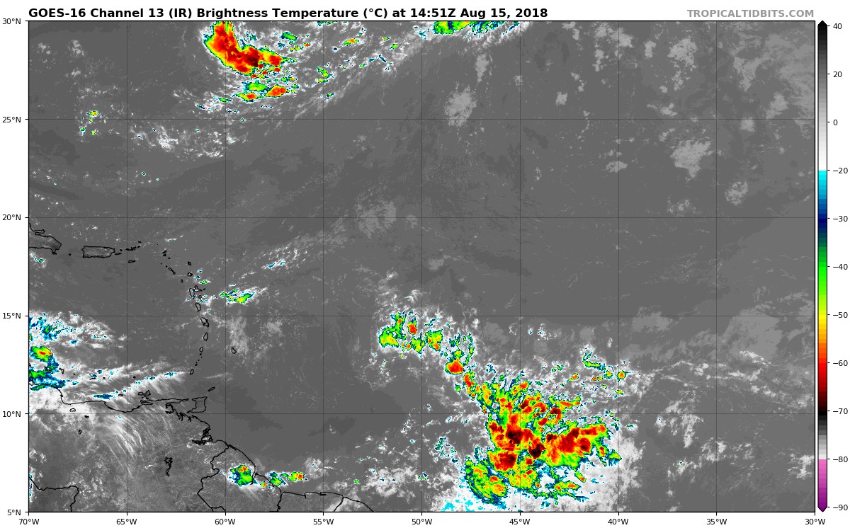
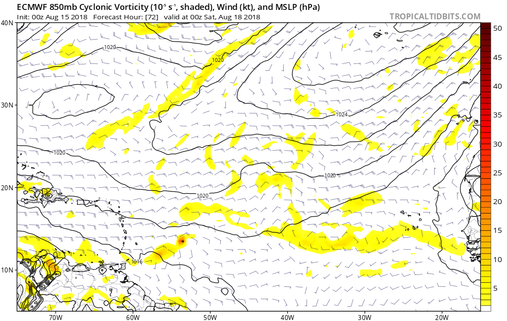
There is nothing else going on in the MDR but it might be worth watching this wave that has flared up overnight given we are at the time of year waves need to be watched closely. The Euro and CMC models develop a small area of 850mb vorticity out of this and notice the GFS builds a large anticyclone over the Eastern Caribbean / Lesser Antilles by days 3 and 4:
Floater loop shows some spin:
http://rammb.cira.colostate.edu/ramsdis ... display=12
Floater loop shows some spin:
http://rammb.cira.colostate.edu/ramsdis ... display=12


Last edited by gatorcane on Wed Aug 15, 2018 10:30 am, edited 2 times in total.
1 likes
Who is online
Users browsing this forum: jhpigott, JtSmarts, MarioProtVI, pepecool20, sasha_B, SFLcane, zal0phus and 24 guests

