Tropical Wave ESE of Lesser Antilles (Is INVEST 99L)
Moderator: S2k Moderators
Forum rules

The posts in this forum are NOT official forecasts and should not be used as such. They are just the opinion of the poster and may or may not be backed by sound meteorological data. They are NOT endorsed by any professional institution or STORM2K. For official information, please refer to products from the National Hurricane Center and National Weather Service.
-
TheStormExpert

- Category 5

- Posts: 8487
- Age: 30
- Joined: Wed Feb 16, 2011 5:38 pm
- Location: Palm Beach Gardens, FL
Re: Tropical Wave ESE of Lesser Antilles
There is currently an enhanced Kelvin Wave traversing this region supporting the increase in convection.
1 likes
The following post is NOT an official forecast and should not be used as such. It is just the opinion of the poster and may or may not be backed by sound meteorological data. It is NOT endorsed by storm2k.org.
-
Shell Mound
- Category 5
- Posts: 2434
- Age: 31
- Joined: Thu Sep 07, 2017 3:39 pm
- Location: St. Petersburg, FL → Scandinavia
Re: Tropical Wave ESE of Lesser Antilles
Fortunately, the strong +NAO pattern over the past several months has induced strong subtropical low-level ridging and enhanced trades over the MDR, which adds up to a feedback loop in which cooler SSTs via trades and SAL also induce upper-level convergence (sinking air) over the region, in turn bolstering PV (that is, TUTT) activity and adding westerly shear to the already-strong low-level easterlies. This makes the current situation over the tropical Atlantic extremely hostile even for robust waves that emerge from West Africa. The same holds true for the Caribbean, which is just as dry and sheared. This current wave is going to continue to struggle in these conditions, even as it heads westward into the Caribbean. Storms that manage to find a proverbial "sweet spot" will most likely be in the subtropics, and that location, barring blocking ridging, might be too far north for systems to affect the U.S. mainland.
https://twitter.com/philklotzbach/status/1027998679255449600
https://twitter.com/pppapin/status/1028036895836499968
https://twitter.com/pppapin/status/1025537174324699136
https://twitter.com/pppapin/status/1025537171975880704
https://twitter.com/pppapin/status/1025537175344082944
https://twitter.com/philklotzbach/status/1027998679255449600
https://twitter.com/pppapin/status/1028036895836499968
https://twitter.com/pppapin/status/1025537174324699136
https://twitter.com/pppapin/status/1025537171975880704
https://twitter.com/pppapin/status/1025537175344082944
0 likes
CVW / MiamiensisWx / Shell Mound
The posts in this forum are NOT official forecasts and should not be used as such. They are just the opinion of the poster and may or may not be backed by sound meteorological data. They are NOT endorsed by any professional institution or STORM2K. For official information, please refer to products from the NHC and NWS.

Re: Tropical Wave ESE of Lesser Antilles
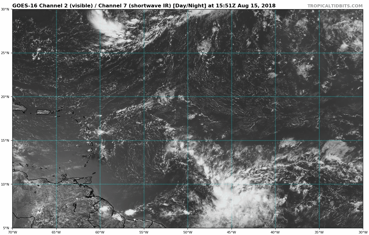
Looks like a swirl getting ready to fire off.
12N 53W
https://www.tropicaltidbits.com/sat/sat ... t=vis-swir
http://rammb-slider.cira.colostate.edu/ ... mmb-slider
12N 53W
https://www.tropicaltidbits.com/sat/sat ... t=vis-swir
http://rammb-slider.cira.colostate.edu/ ... mmb-slider
0 likes
-
gatorcane

- S2K Supporter

- Posts: 23499
- Age: 46
- Joined: Sun Mar 13, 2005 3:54 pm
- Location: Boca Raton, FL
Re: Tropical Wave ESE of Lesser Antilles
CMC a bit more bullish with stronger 850mb vorticity. Day 2 image below east of Lesser Antilles and day 5 just north of Puerto Rico:
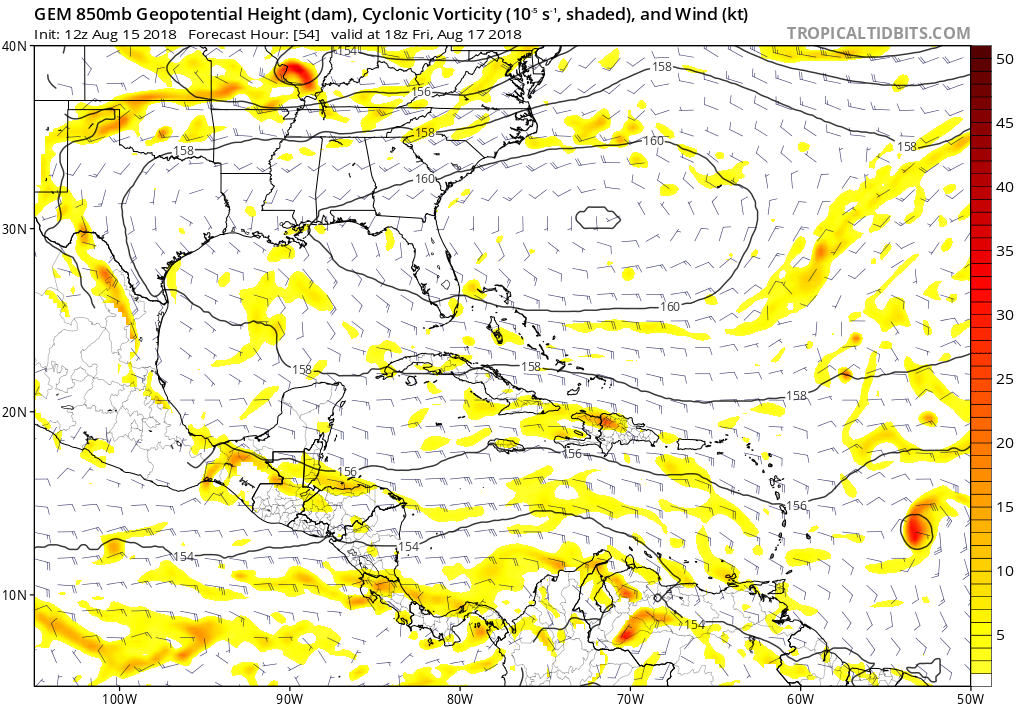
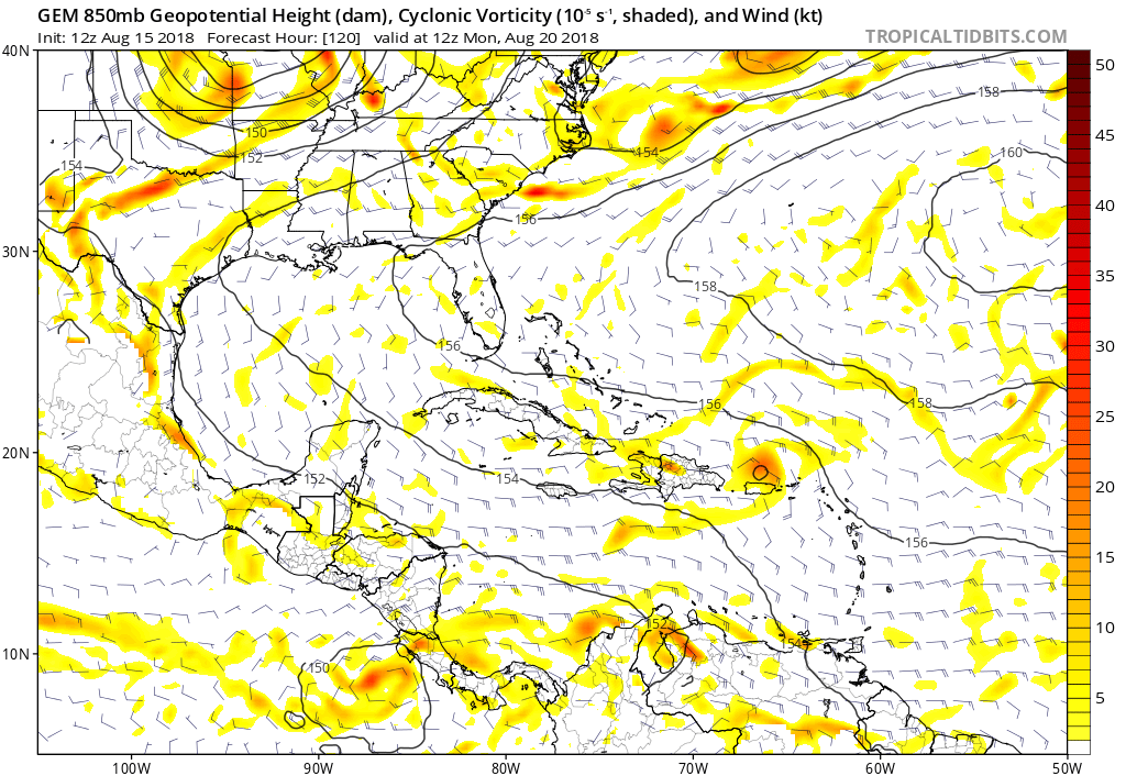
Last edited by gatorcane on Wed Aug 15, 2018 12:06 pm, edited 1 time in total.
0 likes
Re: Tropical Wave ESE of Lesser Antilles
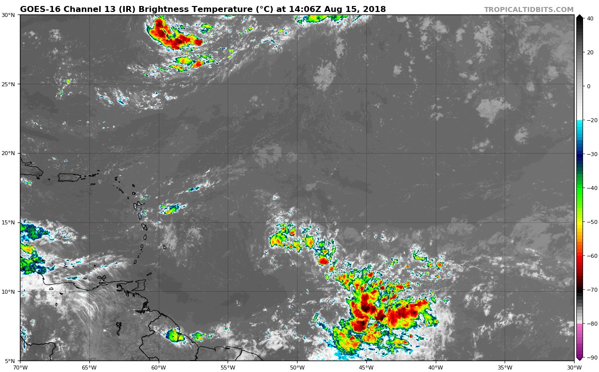
Swirl in some decent CAPE and getting a good feed of ITCZ TPW.
Shear is not bad.
This may fire up in the next 24 hrs or so.
Shear is not bad.
This may fire up in the next 24 hrs or so.
1 likes
Re: Tropical Wave ESE of Lesser Antilles
Respectable drop in surface pressure as the wave passed this buoy.

2 likes
-
floridasun78
- Category 5
- Posts: 3755
- Joined: Sun May 17, 2009 10:16 pm
- Location: miami fl
Re: Tropical Wave ESE of Lesser Antilles
it getting time of year but this year shear been strong and sal for td ot ts form
0 likes

Re: Tropical Wave ESE of Lesser Antilles
GCANE wrote:Respectable drop in surface pressure as the wave passed this buoy.

Is this the system that begins our season? In the model thread, there's something behind this one on the GFS. This could be the precursor.
2 likes
Personal Forecast Disclaimer:
The posts in this forum are NOT official forecast and should not be used as such. They are just the opinion of the poster and may or may not be backed by sound meteorological data. They are NOT endorsed by any professional institution or storm2k.org. For official information, please refer to the NHC and NWS products.
The posts in this forum are NOT official forecast and should not be used as such. They are just the opinion of the poster and may or may not be backed by sound meteorological data. They are NOT endorsed by any professional institution or storm2k.org. For official information, please refer to the NHC and NWS products.
-
gatorcane
- S2K Supporter
- Posts: 23499
- Age: 46
- Joined: Sun Mar 13, 2005 3:54 pm
- Location: Boca Raton, FL
Re: Tropical Wave ESE of Lesser Antilles
Nice looking wave with some broad rotation, saved loop before the sun goes down out there:
2 likes
-
AutoPenalti
- Category 5
- Posts: 3949
- Age: 27
- Joined: Mon Aug 17, 2015 4:16 pm
- Location: Ft. Lauderdale, Florida
Re: Tropical Wave ESE of Lesser Antilles
Euro and GFS in the short term showing nothing but open waves. GFS does however show 2 systems forming at the end of the run.

0 likes
The posts in this forum are NOT official forecasts and should not be used as such. They are just the opinion of the poster and may or may not be backed by sound meteorological data. They are NOT endorsed by any professional institution or STORM2K. For official information, please refer to products from the NHC and NWS.
Model Runs Cheat Sheet:
GFS (5:30 AM/PM, 11:30 AM/PM)
HWRF, GFDL, UKMET, NAVGEM (6:30-8:00 AM/PM, 12:30-2:00 AM/PM)
ECMWF (1:45 AM/PM)
TCVN is a weighted averaged
-
gatorcane
- S2K Supporter
- Posts: 23499
- Age: 46
- Joined: Sun Mar 13, 2005 3:54 pm
- Location: Boca Raton, FL
Re: Tropical Wave ESE of Lesser Antilles
Given the vigorous convection with a favorable upper-level environment and the fact it is heading towards the Lesser Antilles, might be worth a mention by the NHC in its next outlook.
2 likes
-
AutoPenalti
- Category 5
- Posts: 3949
- Age: 27
- Joined: Mon Aug 17, 2015 4:16 pm
- Location: Ft. Lauderdale, Florida
Re: Tropical Wave ESE of Lesser Antilles
If you replay the loop, you can almost see a hint of some spin
1 likes
The posts in this forum are NOT official forecasts and should not be used as such. They are just the opinion of the poster and may or may not be backed by sound meteorological data. They are NOT endorsed by any professional institution or STORM2K. For official information, please refer to products from the NHC and NWS.
Model Runs Cheat Sheet:
GFS (5:30 AM/PM, 11:30 AM/PM)
HWRF, GFDL, UKMET, NAVGEM (6:30-8:00 AM/PM, 12:30-2:00 AM/PM)
ECMWF (1:45 AM/PM)
TCVN is a weighted averaged

Re: Tropical Wave ESE of Lesser Antilles
Yes, there's certainly some rotation occurring. Not sure at what level, though.AutoPenalti wrote:If you replay the loop, you can almost see a hint of some slight spin
0 likes
-
AutoPenalti
- Category 5
- Posts: 3949
- Age: 27
- Joined: Mon Aug 17, 2015 4:16 pm
- Location: Ft. Lauderdale, Florida
Re: Tropical Wave ESE of Lesser Antilles
abajan wrote:Yes, there's certainly some rotation occurring. Not sure at what level, though.AutoPenalti wrote:If you replay the loop, you can almost see a hint of some slight spin
It may be mid-level considering it's still embedded in the ITCZ, but I would just have to wait till tomorrow.
0 likes
The posts in this forum are NOT official forecasts and should not be used as such. They are just the opinion of the poster and may or may not be backed by sound meteorological data. They are NOT endorsed by any professional institution or STORM2K. For official information, please refer to products from the NHC and NWS.
Model Runs Cheat Sheet:
GFS (5:30 AM/PM, 11:30 AM/PM)
HWRF, GFDL, UKMET, NAVGEM (6:30-8:00 AM/PM, 12:30-2:00 AM/PM)
ECMWF (1:45 AM/PM)
TCVN is a weighted averaged

Re: Tropical Wave ESE of Lesser Antilles
AutoPenalti wrote:If you replay the loop, you can almost see a hint of some spin
Is the spin some distance from the deeper convection?
0 likes
-
AutoPenalti
- Category 5
- Posts: 3949
- Age: 27
- Joined: Mon Aug 17, 2015 4:16 pm
- Location: Ft. Lauderdale, Florida
Re: Tropical Wave ESE of Lesser Antilles
Nimbus wrote:AutoPenalti wrote:If you replay the loop, you can almost see a hint of some spin
Is the spin some distance from the deeper convection?
No, I did notice that as well, but if you look a bit closer you can actually see a brief moment of spin embedded in the convection.
0 likes
The posts in this forum are NOT official forecasts and should not be used as such. They are just the opinion of the poster and may or may not be backed by sound meteorological data. They are NOT endorsed by any professional institution or STORM2K. For official information, please refer to products from the NHC and NWS.
Model Runs Cheat Sheet:
GFS (5:30 AM/PM, 11:30 AM/PM)
HWRF, GFDL, UKMET, NAVGEM (6:30-8:00 AM/PM, 12:30-2:00 AM/PM)
ECMWF (1:45 AM/PM)
TCVN is a weighted averaged
-
floridasun78
- Category 5
- Posts: 3755
- Joined: Sun May 17, 2009 10:16 pm
- Location: miami fl
-
cycloneye

- Admin

- Posts: 139151
- Age: 67
- Joined: Thu Oct 10, 2002 10:54 am
- Location: San Juan, Puerto Rico
Re: Tropical Wave ESE of Lesser Antilles
0 likes
Visit the Caribbean-Central America Weather Thread where you can find at first post web cams,radars
and observations from Caribbean basin members Click Here
and observations from Caribbean basin members Click Here
Who is online
Users browsing this forum: Google [Bot], Google Adsense [Bot], Hurricane2022, LarryWx, ouragans, skyline385, SootyTern, Teban54 and 166 guests