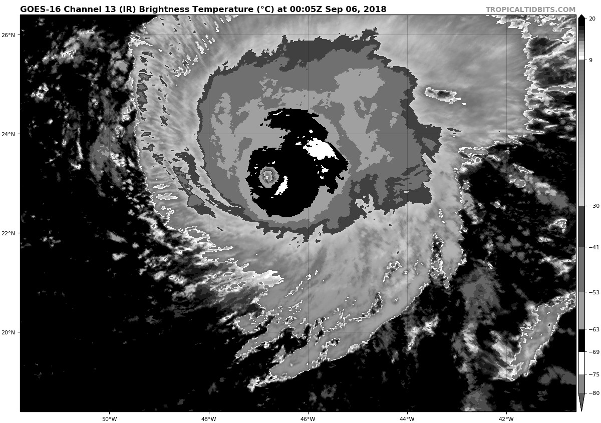
DioBrando wrote:TropTidbits say the machine is now a 115 knot C4...
That's from the Best Track data. So, that's official.
Moderator: S2k Moderators
DioBrando wrote:TropTidbits say the machine is now a 115 knot C4...
plasticup wrote:DioBrando wrote:TropTidbits say the machine is now a 115 knot C4...
That's from the Best Track data. So, that's official.

RL3AO wrote:I'm curious to see the weakening trend when it starts. Sometimes these storms come down as quick as the go up.


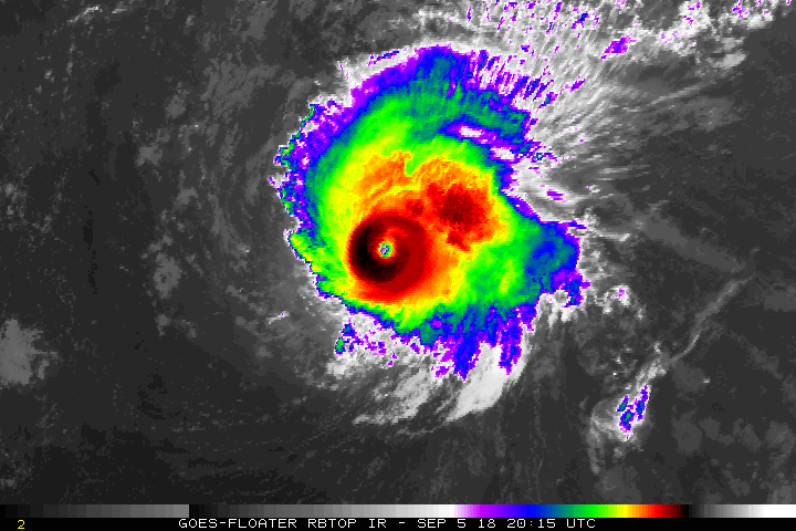
SconnieCane wrote:Where did you get that dvorak floater? Been missing all the enhanced IR products ever since the Atlantic was blacked out on ssd.noaa.gov. They really need to restore those products for GOES-EAST. I love the RBTOP loops from that site in particular.


Hurricane Andrew wrote:I will briefly pop back on to add a note that now sticks in my heart after last season.
Climatology, historical patterns, etc, can mean absolutely squat to a tropical cyclone. It does what it dies; just because it hasn't happened before, or is rare, doesn't mean it won't happen. Irma taught many of us that on a personal level last fall.
LarryWx wrote:Hurricane Andrew wrote:I will briefly pop back on to add a note that now sticks in my heart after last season.
Climatology, historical patterns, etc, can mean absolutely squat to a tropical cyclone. It does what it dies; just because it hasn't happened before, or is rare, doesn't mean it won't happen. Irma taught many of us that on a personal level last fall.
Some people use climo/history the wrong way. It is a very useful tool but rather than provide 100% certainties they provide guidance as to tendencies/probabilities. History may not repeat itself exactly but it will often rhyme.
I'll give an extreme hypothetical example to make a point about the usefulness of climo: no TS+ has moved from N of 34N, 50W, to the CONUS in records back to 1851. Based on this fact, alone, if there is a TS+ at, say 40N, 50W, I'll bet very, very heavily against it later hitting the CONUS not knowing anything else about the TS+ and just using climo. It may not be a 100% chance it will be right in this case, but I'd go with 99%+ in something like this. Climo is also useful in much less extreme scenarios in setting odds or trying to make a prediction.

pcbjr wrote:LarryWx wrote:Hurricane Andrew wrote:I will briefly pop back on to add a note that now sticks in my heart after last season.
Climatology, historical patterns, etc, can mean absolutely squat to a tropical cyclone. It does what it dies; just because it hasn't happened before, or is rare, doesn't mean it won't happen. Irma taught many of us that on a personal level last fall.
Some people use climo/history the wrong way. It is a very useful tool but rather than provide 100% certainties they provide guidance as to tendencies/probabilities. History may not repeat itself exactly but it will often rhyme.
I'll give an extreme hypothetical example to make a point about the usefulness of climo: no TS+ has moved from N of 34N, 50W, to the CONUS in records back to 1851. Based on this fact, alone, if there is a TS+ at, say 40N, 50W, I'll bet very, very heavily against it later hitting the CONUS not knowing anything else about the TS+ and just using climo. It may not be a 100% chance it will be right in this case, but I'd go with 99%+ in something like this. Climo is also useful in much less extreme scenarios in setting odds or trying to make a prediction.
Larry,
I'll go with this ... they always, always show up, where you least want them ... if you live there ...
LarryWx wrote:Hurricane Andrew wrote:I will briefly pop back on to add a note that now sticks in my heart after last season.
Climatology, historical patterns, etc, can mean absolutely squat to a tropical cyclone. It does what it dies; just because it hasn't happened before, or is rare, doesn't mean it won't happen. Irma taught many of us that on a personal level last fall.
Some people use climo/history the wrong way. It is a very useful tool but rather than provide 100% certainties they provide guidance as to tendencies/probabilities. History may not repeat itself exactly but it will often rhyme.
I'll give an extreme hypothetical example to make a point about the usefulness of climo: no TS+ has moved from N of 34N, 50W, to the CONUS in records back to 1851. Based on this fact, alone, if there is a TS+ at, say 40N, 50W, I'll bet very, very heavily against it later hitting the CONUS not knowing anything else about the TS+ and just using climo. It may not be a 100% chance it will be right in this case, but I'd go with 99%+ in something like this. Climo is also useful in much less extreme scenarios in setting odds or trying to make a prediction.


LarryWx wrote:pcbjr wrote:LarryWx wrote:
Some people use climo/history the wrong way. It is a very useful tool but rather than provide 100% certainties they provide guidance as to tendencies/probabilities. History may not repeat itself exactly but it will often rhyme.
I'll give an extreme hypothetical example to make a point about the usefulness of climo: no TS+ has moved from N of 34N, 50W, to the CONUS in records back to 1851. Based on this fact, alone, if there is a TS+ at, say 40N, 50W, I'll bet very, very heavily against it later hitting the CONUS not knowing anything else about the TS+ and just using climo. It may not be a 100% chance it will be right in this case, but I'd go with 99%+ in something like this. Climo is also useful in much less extreme scenarios in setting odds or trying to make a prediction.
Larry,
I'll go with this ... they always, always show up, where you least want them ... if you live there ...
Or they will always go to where Jim Cantore is reporting from, climo supported or not!

Users browsing this forum: No registered users and 42 guests