Looks like 94L is here.
AL942018 - INVEST
201809071200 30 -68.8
http://rammb.cira.colostate.edu/products/tc_realtime/
ATL: INVEST 94L - Discussion
Moderator: S2k Moderators
-
NotSparta

- Professional-Met

- Posts: 1649
- Age: 22
- Joined: Fri Aug 18, 2017 8:24 am
- Location: Naples, FL
- Contact:
ATL: INVEST 94L - Discussion
0 likes
This post was probably an opinion of mine, and in no way is official. Please refer to http://www.hurricanes.gov for official tropical analysis and advisories.
My website, with lots of tropical wx graphics, including satellite and recon: http://cyclonicwx.com
My website, with lots of tropical wx graphics, including satellite and recon: http://cyclonicwx.com
-
tolakram
- Admin

- Posts: 19165
- Age: 60
- Joined: Sun Aug 27, 2006 8:23 pm
- Location: Florence, KY (name is Mark)
Re: ATL: INVEST 94L - Discussion
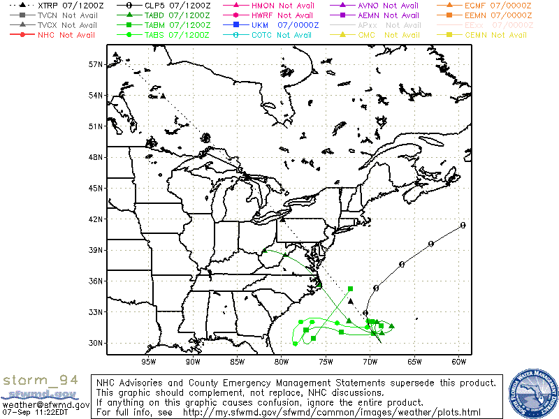
AL, 94, 2018090612, , BEST, 0, 270N, 653W, 20, 1015, DB, 0, , 0, 0, 0, 0, 1017, 120, 90, 0, 0, , 0, , 0, 0, INVEST, ,
AL, 94, 2018090618, , BEST, 0, 276N, 661W, 20, 1015, DB, 0, , 0, 0, 0, 0, 1017, 120, 90, 0, 0, , 0, , 0, 0, INVEST, ,
AL, 94, 2018090700, , BEST, 0, 280N, 671W, 20, 1015, DB, 0, , 0, 0, 0, 0, 1017, 120, 90, 0, 0, , 0, , 0, 0, INVEST, ,
AL, 94, 2018090706, , BEST, 0, 289N, 681W, 20, 1015, DB, 0, , 0, 0, 0, 0, 1017, 120, 90, 0, 0, , 0, , 0, 0, INVEST, ,
AL, 94, 2018090712, , BEST, 0, 300N, 688W, 20, 1015, DB, 34, NEQ, 0, 0, 0, 0, 1017, 120, 90, 0, 0, L, 0, , 0, 0, INVEST, S,
1 likes
M a r k
- - - - -
Join us in chat: Storm2K Chatroom Invite. Android and IOS apps also available.
The posts in this forum are NOT official forecasts and should not be used as such. Posts are NOT endorsed by any professional institution or STORM2K.org. For official information and forecasts, please refer to NHC and NWS products.
-
NotSparta
- Professional-Met
- Posts: 1649
- Age: 22
- Joined: Fri Aug 18, 2017 8:24 am
- Location: Naples, FL
- Contact:
Re: ATL: INVEST 94L - Discussion
tolakram wrote:Might have been a mistake. We have EIGHT but no 94 yet.
The RAMMB site is showing it as the area of convection Levi Cowan was talking about earlier
http://rammb.cira.colostate.edu/product ... r=AL942018
1 likes
This post was probably an opinion of mine, and in no way is official. Please refer to http://www.hurricanes.gov for official tropical analysis and advisories.
My website, with lots of tropical wx graphics, including satellite and recon: http://cyclonicwx.com
My website, with lots of tropical wx graphics, including satellite and recon: http://cyclonicwx.com
-
AJC3

- Admin
- Posts: 3873
- Age: 60
- Joined: Tue Aug 31, 2004 7:04 pm
- Location: West Melbourne, Florida
- Contact:
Re: ATL: INVEST 94L - Discussion
1 likes
-
tolakram
- Admin
- Posts: 19165
- Age: 60
- Joined: Sun Aug 27, 2006 8:23 pm
- Location: Florence, KY (name is Mark)
Re: ATL: INVEST 94L - Discussion
I wonder what the secret is to getting information faster than best track? 
2 likes
M a r k
- - - - -
Join us in chat: Storm2K Chatroom Invite. Android and IOS apps also available.
The posts in this forum are NOT official forecasts and should not be used as such. Posts are NOT endorsed by any professional institution or STORM2K.org. For official information and forecasts, please refer to NHC and NWS products.
- - - - -
Join us in chat: Storm2K Chatroom Invite. Android and IOS apps also available.
The posts in this forum are NOT official forecasts and should not be used as such. Posts are NOT endorsed by any professional institution or STORM2K.org. For official information and forecasts, please refer to NHC and NWS products.
-
AJC3
- Admin
- Posts: 3873
- Age: 60
- Joined: Tue Aug 31, 2004 7:04 pm
- Location: West Melbourne, Florida
- Contact:
Re: ATL: INVEST 94L - Discussion
tolakram wrote:I wonder what the secret is to getting information faster than best track?
Whatever it is, it hasn't been shared with me... lol
3 likes


Re: ATL: INVEST 94L - Discussion
AJC3 wrote:tolakram wrote:I wonder what the secret is to getting information faster than best track?
Whatever it is, it hasn't been shared with me... lol
Maybe he is Levi.
0 likes
Personal Forecast Disclaimer:
The posts in this forum are NOT official forecast and should not be used as such. They are just the opinion of the poster and may or may not be backed by sound meteorological data. They are NOT endorsed by any professional institution or storm2k.org. For official information, please refer to the NHC and NWS products.
The posts in this forum are NOT official forecast and should not be used as such. They are just the opinion of the poster and may or may not be backed by sound meteorological data. They are NOT endorsed by any professional institution or storm2k.org. For official information, please refer to the NHC and NWS products.
-
NotSparta
- Professional-Met
- Posts: 1649
- Age: 22
- Joined: Fri Aug 18, 2017 8:24 am
- Location: Naples, FL
- Contact:
Re: ATL: INVEST 94L - Discussion
Blinhart wrote:AJC3 wrote:tolakram wrote:I wonder what the secret is to getting information faster than best track?
Whatever it is, it hasn't been shared with me... lol
Maybe he is Levi.
Even Levi hasn't figured that out, isn't up on his site yet
1 likes
This post was probably an opinion of mine, and in no way is official. Please refer to http://www.hurricanes.gov for official tropical analysis and advisories.
My website, with lots of tropical wx graphics, including satellite and recon: http://cyclonicwx.com
My website, with lots of tropical wx graphics, including satellite and recon: http://cyclonicwx.com
-
TheAustinMan

- Category 4

- Posts: 997
- Age: 24
- Joined: Mon Jul 08, 2013 4:26 pm
- Location: United States
- Contact:
Re: ATL: INVEST 94L - Discussion
Been watching some of the high-resolution shortwave IR/visible/nighttime microphysics on this for a bit. I think based on the cloud motions this morning, 94L already has a weak but closed circulation. Now whether the convective structure and closed circulation are good enough for the tropical cyclone definition... probably not. There are however numerous cumulus streets that trace out the curving westerly to southerly flow south of 94L. Reminds me some of the progenitor to Chris from earlier this year, actually, which had very little model support to begin with. Way more moving parts to deal with this time around though with Florence nearby.
0 likes


Treat my opinions with a grain of salt. For official information see your local weather service.

Re: ATL: INVEST 94L - Discussion
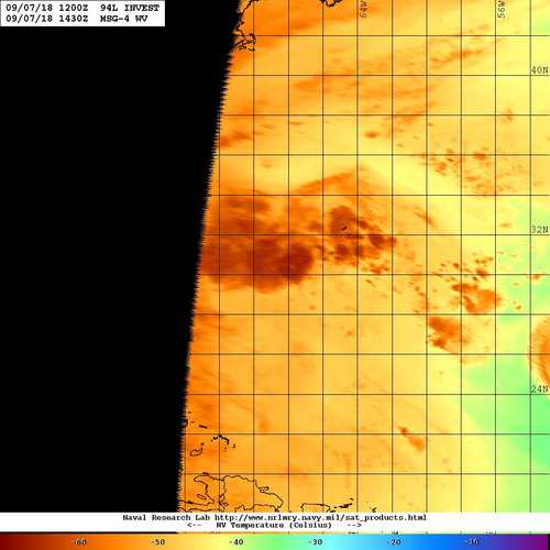
94L.INVEST, VAPOR, 07 SEP 2018 1430Z
UTC (Z)
Tutorials:
Overview
COMET
Vapor
| /SATPRODUCTS/TC/tc18/ATL/94L.INVEST/vapor/geo/1km
20180907.1430.msg4.x.wv1km.94LINVEST.20kts-1015mb-300N-688W.63pc.jpg |
https://www.nrlmry.navy.mil/tc-bin/tc_h ... PROD=vapor
UTC (Z)
Tutorials:
Overview
COMET
Vapor
| /SATPRODUCTS/TC/tc18/ATL/94L.INVEST/vapor/geo/1km
20180907.1430.msg4.x.wv1km.94LINVEST.20kts-1015mb-300N-688W.63pc.jpg |
https://www.nrlmry.navy.mil/tc-bin/tc_h ... PROD=vapor
0 likes

Re: ATL: INVEST 94L - Discussion
GCANE wrote:Last week it was crickets, this week locusts
That perfectly sums up the situation.
4 likes
Re: ATL: INVEST 94L - Discussion
Last edited by artist on Fri Sep 07, 2018 10:22 am, edited 1 time in total.
0 likes
-
tropicwatch

- Category 5

- Posts: 3205
- Age: 60
- Joined: Sat Jun 02, 2007 10:01 am
- Location: Panama City Florida
- Contact:
Re: ATL: INVEST 94L - Discussion
Will they wait for the next two or give out a special one?
0 likes
Tropicwatch
Agnes 72', Eloise 75, Elena 85', Kate 85', Charley 86', Florence 88', Beryl 94', Dean 95', Erin 95', Opal 95', Earl 98', Georges 98', Ivan 2004', Arlene 2005', Dennis 2005', Ida 2009' Debby 2012' Irma 2017' Michael 2018'
Agnes 72', Eloise 75, Elena 85', Kate 85', Charley 86', Florence 88', Beryl 94', Dean 95', Erin 95', Opal 95', Earl 98', Georges 98', Ivan 2004', Arlene 2005', Dennis 2005', Ida 2009' Debby 2012' Irma 2017' Michael 2018'


-
Kazmit

- Category 5
- Posts: 1915
- Age: 21
- Joined: Mon Jul 25, 2016 8:49 am
- Location: Williamsburg VA for college, Bermuda otherwise
Re: ATL: INVEST 94L - Discussion
This is giving us some much needed thunderstorms and rain today.
1 likes
Igor 2010, Sandy 2012, Fay 2014, Gonzalo 2014, Joaquin 2015, Nicole 2016, Humberto 2019
I am only a tropical weather enthusiast. My predictions are not official and may or may not be backed by sound meteorological data. For official information, please refer to the NHC and NWS products.
I am only a tropical weather enthusiast. My predictions are not official and may or may not be backed by sound meteorological data. For official information, please refer to the NHC and NWS products.
-
EquusStorm

- Category 5
- Posts: 1649
- Age: 33
- Joined: Thu Nov 07, 2013 1:04 pm
- Location: Jasper, AL
- Contact:
Re: ATL: INVEST 94L - Discussion
As I'm still kinda tracking the diffuse remnants of Gordon, there is honestly almost too much in the basin for me to keep track of right now. What an amazing contrast to most of August; peak to late season has been king lately
2 likes
Colors of lost purpose on the canvas of irrelevance
Not a meteorologist, in fact more of an idiot than anything. You should probably check with the NHC or a local NWS office for official information.
Not a meteorologist, in fact more of an idiot than anything. You should probably check with the NHC or a local NWS office for official information.
Who is online
Users browsing this forum: No registered users and 97 guests