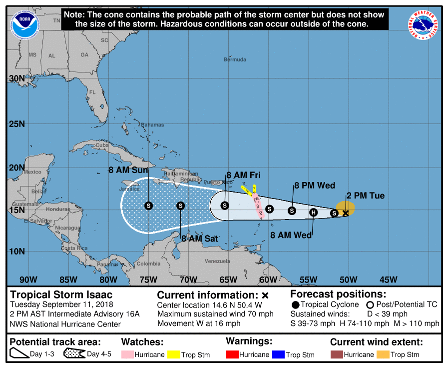
ATL: ISAAC - Post-Tropical - Discussion

Moderator: S2k Moderators

Message
Author
User avatar
artist
Category 5
Category 5
Posts: 9793
Joined: Mon Jun 06, 2005 3:26 pm
Location: West Palm

Re: ATL: ISAAC - Evacuations, Closing and Observations

#521 Postby artist » Tue Sep 11, 2018 12:54 pm

Gustywind wrote:
Blinhart wrote:
Gustywind wrote:Aric Dunn :) i would like to have your latest thoughts about Isaac? Thanks.


I think he is traveling today.

You think? wow, let's hope no... i appreciate his forecasts often great and accurate... :)

Hey, Gusty, I contacted him for you. Here is his reply-

Luckily, low level shear from its forward speed should keep it from becoming anything more than a minimal hurricane. Could even stay a TS. should also pass by pretty fast from the forward speed.

Tell him not to worry it would be a major hurricane. :)
2 likes   

User avatar
cycloneye
Admin
Admin
Posts: 139028
Age: 67
Joined: Thu Oct 10, 2002 10:54 am
Location: San Juan, Puerto Rico

Re: ATL: ISAAC - Recon

#522 Postby cycloneye » Tue Sep 11, 2018 1:07 pm

TROPICAL STORM ISAAC
FLIGHT ONE -- NOAA 42 FLIGHT TWO -- NOAA 42
A. 12/2330Z,13/0530Z A. 13/1130Z,1730Z
B. NOAA2 0209A ISAAC B. NOAA2 0309A ISAAC
C. 12/2130Z C. 13/1000Z
D. 14.7N 57.1W D. 15.1N 59.9W
E. 12/2300Z TO 13/0530Z E. 13/1100Z TO 13/1730Z
F. SFC TO 10,000 FT F. SFC TO 10,000 FT
0 likes   
Visit the Caribbean-Central America Weather Thread where you can find at first post web cams,radars
and observations from Caribbean basin members Click Here

User avatar
chaser1
S2K Supporter
S2K Supporter
Posts: 4680
Age: 63
Joined: Sat Oct 15, 2005 5:59 pm
Location: Longwood, Fl

Re: ATL: ISAAC - Tropical Storm - Discussion

#523 Postby chaser1 » Tue Sep 11, 2018 1:10 pm

Michele B wrote:


RUT ROH, SHAGGY!!!!


That possibility threat along with the HWRF predicting a weak Isaac to sneak south of Puerto Rico and then significantly strengthen as it moves west to wnw in the North Central Caribbean. Isaac has been a squirrely storm to figure out and certainly something not to lose sight of in light of the larger Florence landfall soon to take place. Assuming Isaac retains (or re-intensifies) it's vertical integrity, then I could see one of a couple different scenarios that could play out.

One future potential track could be a brief stall near or east of Jamaica followed by a slow northward motion crossing Cuba to near Andros Island off S. Florida, and then a NNE motion into the break within the W. Atlantic ridge where a southerly steering flow temporarily would exist as a result of Florence's large influence. Another possibility that I could see play out would be for Isaac to cross the Leeward Islands and begin a slight WNW motion toward Eastern Cuba where steering might temporarily break down as a result of a departing Florence to it's north and rebuilding mid level heights along the Southeast Seaboard in her wake. Then, a rebuilding ridge of high pressure could potentially drive Isaac WNW to parallel the (Northern or Southern) Cuban coastline and eventually moving more Northwestward and towards the N. Gulf Coast, perhaps close to S.E. Texas or Louisiana.
0 likes   
Personal Forecast Disclaimer:
The posts in this forum are NOT official forecast and should not be used as such. They are just the opinion of the poster and may or may not be backed by sound meteorological data. They are NOT endorsed by any professional institution or storm2k.org. For official information, please refer to the NHC and NWS products.


User avatar
chaser1
S2K Supporter
S2K Supporter
Posts: 4680
Age: 63
Joined: Sat Oct 15, 2005 5:59 pm
Location: Longwood, Fl

Re: ATL: ISAAC - Tropical Storm - Discussion

#524 Postby chaser1 » Tue Sep 11, 2018 1:22 pm

SoupBone wrote:
chaser1 wrote:
zeehag wrote:my vene friend who lives on isla margherita is crying for lack of water. her cisterna is almost empty. she is praying for rain from isaac to help them out. i am hoping these folks get some relief from their drought via isaac. unfortunately the storm looks like an icepick...too small to grant the wish.


Where even is Isla Margherita?? West of Trinidad off the coast of Venezuela?


Winner winner, chicken dinner.


I'll take my chicken extra fried (like the Colonel makes it :wink: )
As for the chances of Isla Margherita getting any rain as a result of Isaac????? I'd venture to guess that the odds of Bermuda getting rain from Isaac to be about 3X's as likely. Nova Scotia might even have better odds of seeing Isaac related precip then Isla Margherita. If I were her, I'd buy a dehumidifier and let it run outside - non stop. It's bucket would collect anywhere from 30-70 pints of water in a 24 hr. period. Sadly, finding one there on the island might be tough yet here in Florida you can find hundreds of 'em for sale (some for $25- $50)
1 likes   
Personal Forecast Disclaimer:
The posts in this forum are NOT official forecast and should not be used as such. They are just the opinion of the poster and may or may not be backed by sound meteorological data. They are NOT endorsed by any professional institution or storm2k.org. For official information, please refer to the NHC and NWS products.


User avatar
Gustywind
Category 5
Category 5
Posts: 12334
Joined: Mon Sep 03, 2007 7:29 am
Location: Baie-Mahault, GUADELOUPE

Re: ATL: ISAAC - Evacuations, Closing and Observations

#525 Postby Gustywind » Tue Sep 11, 2018 1:22 pm

artist wrote:
Gustywind wrote:
Blinhart wrote:
I think he is traveling today.

You think? wow, let's hope no... i appreciate his forecasts often great and accurate... :)

Hey, Gusty, I contacted him for you. Here is his reply-

Luckily, low level shear from its forward speed should keep it from becoming anything more than a minimal hurricane. Could even stay a TS. should also pass by pretty fast from the forward speed.

Tell him not to worry it would be a major hurricane. :)

ok THANKS! :)
1 likes   

User avatar
Blinhart
Category 5
Category 5
Posts: 1981
Age: 47
Joined: Thu Sep 08, 2011 3:13 pm
Location: Crowley, La.

Re: ATL: ISAAC - Tropical Storm - Discussion

#526 Postby Blinhart » Tue Sep 11, 2018 1:30 pm

chaser1 wrote:
Michele B wrote:


RUT ROH, SHAGGY!!!!


That possibility threat along with the HWRF predicting a weak Isaac to sneak south of Puerto Rico and then significantly strengthen as it moves west to wnw in the North Central Caribbean. Isaac has been a squirrely storm to figure out and certainly something not to lose sight of in light of the larger Florence landfall soon to take place. Assuming Isaac retains (or re-intensifies) it's vertical integrity, then I could see one of a couple different scenarios that could play out.

One future potential track could be a brief stall near or east of Jamaica followed by a slow northward motion crossing Cuba to near Andros Island off S. Florida, and then a NNE motion into the break within the W. Atlantic ridge where a southerly steering flow temporarily would exist as a result of Florence's large influence. Another possibility that I could see play out would be for Isaac to cross the Leeward Islands and begin a slight WNW motion toward Eastern Cuba where steering might temporarily break down as a result of a departing Florence to it's north and rebuilding mid level heights along the Southeast Seaboard in her wake. Then, a rebuilding ridge of high pressure could potentially drive Isaac WNW to parallel the (Northern or Southern) Cuban coastline and eventually moving more Northwestward and towards the N. Gulf Coast, perhaps close to S.E. Texas or Louisiana.

I really hope you are wrong on either of them. Just needs to go straight into C.A.
0 likes   
Personal Forecast Disclaimer:
The posts in this forum are NOT official forecast and should not be used as such. They are just the opinion of the poster and may or may not be backed by sound meteorological data. They are NOT endorsed by any professional institution or storm2k.org. For official information, please refer to the NHC and NWS products.

User avatar
artist
Category 5
Category 5
Posts: 9793
Joined: Mon Jun 06, 2005 3:26 pm
Location: West Palm

Re: ATL: ISAAC - Evacuations, Closing and Observations

#527 Postby artist » Tue Sep 11, 2018 3:05 pm

Image
0 likes   

User avatar
artist
Category 5
Category 5
Posts: 9793
Joined: Mon Jun 06, 2005 3:26 pm
Location: West Palm

Re: ATL: ISAAC - Evacuations, Closing and Observations

#528 Postby artist » Tue Sep 11, 2018 3:07 pm

Day One...Today and Tonight

.Thunderstorms...There is a chance of thunderstorms with heavy
rainfall and brief gusty winds this afternoon across the northern
half of Puerto Rico, including the San Juan metropolitan area.

.Flooding...Heavy rains could lead to urban and small stream
flooding.

.Waves...Seas up to 6 feet expected across offshore and nearshore Atlantic
waters and Mona Passage.

.Rip Currents...There is a high risk of rip currents for beaches along
the north coast of Puerto Rico.

.Heat...Southeasterly trade winds will result in heat index between
102 and 107 degrees across portions of southern and eastern Puerto
Rico, as well as portions of southern Vieques.

.Days Two through Seven...Wednesday through Monday

A patch of dry air will result in limited shower activity on
Wednesday. Although Tropical Cyclone Isaac is expected to move south
of the local area by the end of the week, Isaac`s outer bands and
associated moisture will enhance shower and thunderstorm activity, as
well as gusty conditions across the local islands late Wednesday night
through the weekend. A more seasonal pattern will return once again
on Monday. The high risk of rip currents will continue until early
next week.

.Spotter information statement...

Widespread spotter activation is not anticipated, however individual
spotter are encouraged to report flooding and rip currents to the
National Weather Service in San Juan.
0 likes   

User avatar
artist
Category 5
Category 5
Posts: 9793
Joined: Mon Jun 06, 2005 3:26 pm
Location: West Palm

Re: ATL: ISAAC - Evacuations, Closing and Observations

#529 Postby artist » Tue Sep 11, 2018 3:09 pm

Saint Marteen
SPECIAL FEATURE:
At 11am, the center of Tropical Storm Isaac was located near latitude 14.6 north, longitude 49.7 west or about 920 miles east-southeast of St Maarten. Isaac is moving toward the west near 16 mph with maximum sustained winds near 70 mph and higher gusts. Little change in strength is forecast during the next few days. On this forecast track the center of Isaac is expected to be at its closest point to St. Maarten on early Friday morning about 185 miles away.
0 likes   

User avatar
Gustywind
Category 5
Category 5
Posts: 12334
Joined: Mon Sep 03, 2007 7:29 am
Location: Baie-Mahault, GUADELOUPE

Re: ATL: ISAAC - Tropical Storm - Discussion

#530 Postby Gustywind » Tue Sep 11, 2018 3:41 pm

563
WTNT34 KNHC 112032
TS Isaac continues westward towards the Lesser Antilles!

BULLETIN
Tropical Storm Isaac Advisory Number 17
NWS National Hurricane Center Miami FL AL092018
500 PM AST Tue Sep 11 2018

...WARNINGS LIKELY TO BE ISSUED TONIGHT FOR ISAAC...


SUMMARY OF 500 PM AST...2100 UTC...INFORMATION
----------------------------------------------
LOCATION...14.6N 51.3W
ABOUT 670 MI...1075 KM E OF THE LESSER ANTILLES
MAXIMUM SUSTAINED WINDS...70 MPH...110 KM/H
PRESENT MOVEMENT...W OR 270 DEGREES AT 17 MPH...28 KM/H
MINIMUM CENTRAL PRESSURE...996 MB...29.42 INCHES
1 likes   

User avatar
cycloneye
Admin
Admin
Posts: 139028
Age: 67
Joined: Thu Oct 10, 2002 10:54 am
Location: San Juan, Puerto Rico

Re: ATL: ISAAC - Advisories

#531 Postby cycloneye » Tue Sep 11, 2018 3:50 pm

BULLETIN
Tropical Storm Isaac Advisory Number 17
NWS National Hurricane Center Miami FL AL092018
500 PM AST Tue Sep 11 2018

...WARNINGS LIKELY TO BE ISSUED TONIGHT FOR ISAAC...


SUMMARY OF 500 PM AST...2100 UTC...INFORMATION
----------------------------------------------
LOCATION...14.6N 51.3W
ABOUT 670 MI...1075 KM E OF THE LESSER ANTILLES
MAXIMUM SUSTAINED WINDS...70 MPH...110 KM/H
PRESENT MOVEMENT...W OR 270 DEGREES AT 17 MPH...28 KM/H
MINIMUM CENTRAL PRESSURE...996 MB...29.42 INCHES


Tropical Storm Isaac Discussion Number 17
NWS National Hurricane Center Miami FL AL092018
500 PM AST Tue Sep 11 2018

Microwave and visible satellite data show that the center of Isaac
is partially exposed on the western edge of the central dense
overcast. Perhaps Isaac is a little weaker than earlier, but a
blend of the latest subjective and objective estimates still gives
an uncertain initial wind speed of about 60 kt. We should have a
better idea of the maximum winds by tomorrow morning when a NOAA
Hurricane Hunter enters the storm, or if we get lucky with a
scatterometer pass this evening.

Isaac is barely holding on in the face of increasing shear, which
is much more evident in the 300-500 mb layer than a conventional
analysis at 200 mb. However, convection could redevelop near the
center while the storm moves over warming SSTs into a more moist and
unstable environment east of the Lesser Antilles. These
conflicting factors lead to a forecast of little change in the winds
of Isaac until the cyclone moves into the eastern Caribbean. I
should mention that the short-term trend on satellite makes me think
the intensity forecast is too high over the next 36 hours. Yet,
given our limited skill in forecasting intensity changes in marginal
environments, plus the 5 or 10 kt of initial wind speed uncertainty,
this is the course of least regret. We can see if this trend
becomes more consistent before making substantial changes on the
next advisory. Model guidance is very divergent in the long range
for Isaac, with the regional hurricane and statistical models
showing intensification, while the global models show continued
weakening. The global models have done fairly well with this
cyclone, so the forecast will lean more heavily on their weaker
solutions.

The latest initial motion estimate is 270/15, a little faster than
before. Isaac is forecast to move westward at roughly the same
speed for the next few days due to a mid-level ridge over the
central Atlantic Ocean. Model guidance is tightly clustered on this
cycle, with the UKMET now coming into good agreement with the rest
of the guidance. The only change to this forecast is to accelerate
Isaac roughly 1 kt over the course of the prediction, which over the
course of a 5-day forecast results in a sizable westward shift.
This forecast could still be too slow, since the GFS and ECMWF are
a bit ahead of the new NHC track prediction.

Key Messages:

1. Isaac is expected to be at or near hurricane intensity when it
approaches the Lesser Antilles on Thursday, and hurricane and
tropical storm watches have been issued for several islands.
Interests in those areas should follow any advice given by their
local officials, and warnings will likely be issued this evening.

2. Interests elsewhere in the Lesser Antilles should continue to
monitor Isaac during the next couple of days.


FORECAST POSITIONS AND MAX WINDS

INIT 11/2100Z 14.6N 51.3W 60 KT 70 MPH
12H 12/0600Z 14.6N 53.4W 60 KT 70 MPH
24H 12/1800Z 14.8N 56.2W 60 KT 70 MPH
36H 13/0600Z 15.0N 59.2W 60 KT 70 MPH
48H 13/1800Z 15.3N 62.3W 55 KT 65 MPH
72H 14/1800Z 15.5N 68.5W 50 KT 60 MPH
96H 15/1800Z 15.5N 73.5W 45 KT 50 MPH
120H 16/1800Z 15.5N 77.5W 45 KT 50 MPH

$$
Forecaster Blake
0 likes   
Visit the Caribbean-Central America Weather Thread where you can find at first post web cams,radars
and observations from Caribbean basin members Click Here

User avatar
artist
Category 5
Category 5
Posts: 9793
Joined: Mon Jun 06, 2005 3:26 pm
Location: West Palm

Re: ATL: ISAAC - Evacuations, Closing and Observations

#532 Postby artist » Tue Sep 11, 2018 3:52 pm

WARNINGS LIKELY TO BE ISSUED TONIGHT FOR ISAAC...


SUMMARY OF 500 PM AST...2100 UTC...INFORMATION
----------------------------------------------
LOCATION...14.6N 51.3W
ABOUT 670 MI...1075 KM E OF THE LESSER ANTILLES
MAXIMUM SUSTAINED WINDS...70 MPH...110 KM/H
PRESENT MOVEMENT...W OR 270 DEGREES AT 17 MPH...28 KM/H
MINIMUM CENTRAL PRESSURE...996 MB...29.42 INCHES
0 likes   

redneck51
S2K Supporter
S2K Supporter
Posts: 60
Joined: Sat Sep 05, 2009 3:25 pm

Re: ATL: ISAAC - Tropical Storm - Discussion

#533 Postby redneck51 » Tue Sep 11, 2018 3:53 pm

NHC - Isaac discussion 5PM wrote:Isaac is barely holding on in the face of increasing shear, which
is much more evident in the 300-500 mb layer than a conventional
analysis at 200 mb.
3 likes   

User avatar
Gustywind
Category 5
Category 5
Posts: 12334
Joined: Mon Sep 03, 2007 7:29 am
Location: Baie-Mahault, GUADELOUPE

Re: ATL: ISAAC - Evacuations, Closing and Observations

#534 Postby Gustywind » Tue Sep 11, 2018 3:59 pm

WATCHES AND WARNINGS
--------------------
CHANGES WITH THIS ADVISORY:

None.

SUMMARY OF WATCHES AND WARNINGS IN EFFECT:

A Hurricane Watch is in effect for...
* Guadeloupe
* Martinique
* Dominica

A Tropical Storm Watch is in effect for...
* Antigua
* Montserrat
* St. Kitts and Nevis
1 likes   

User avatar
SoupBone
Category 5
Category 5
Posts: 3073
Joined: Tue Sep 20, 2005 5:24 pm

Re: ATL: ISAAC - Tropical Storm - Discussion

#535 Postby SoupBone » Tue Sep 11, 2018 4:01 pm

redneck51 wrote:
NHC - Isaac discussion 5PM wrote:Isaac is barely holding on in the face of increasing shear, which
is much more evident in the 300-500 mb layer than a conventional
analysis at 200 mb.


Crazy that, barring no changes (yeah we know how weather does though), this is what some models had been predicting. A weakening before impacting the islands with a tropcial storm, followed by it getting destroyed in the Caribbean. Hopefully, it weakens more before the islands.
1 likes   
Personal Forecast Disclaimer:
The posts in this forum are NOT official forecast and should not be used as such. They are just the opinion of the poster and may or may not be backed by sound meteorological data. They are NOT endorsed by any professional institution or storm2k.org. For official information, please refer to the NHC and NWS products.

User avatar
NDG
S2K Supporter
S2K Supporter
Posts: 14933
Joined: Sun Jul 09, 2006 10:14 pm
Location: Orlando, FL

Re: ATL: ISAAC - Tropical Storm - Discussion

#536 Postby NDG » Tue Sep 11, 2018 4:13 pm

SoupBone wrote:
redneck51 wrote:
NHC - Isaac discussion 5PM wrote:Isaac is barely holding on in the face of increasing shear, which
is much more evident in the 300-500 mb layer than a conventional
analysis at 200 mb.


Crazy that, barring no changes (yeah we know how weather does though), this is what some models had been predicting. A weakening before impacting the islands with a tropcial storm, followed by it getting destroyed in the Caribbean. Hopefully, it weakens more before the islands.


As they mentioned, though it looks like it has a beautiful outflow at h200 it is the mid level shear that has it big time tilted with the mid level vorticity trailing behind the LLC.
I'm having a hard time believing that it will be totally destroyed as it tracks over the Caribbean, it may have chance to restrengthen over the western Caribbean, still a lot up in the air.

Image
2 likes   

User avatar
NDG
S2K Supporter
S2K Supporter
Posts: 14933
Joined: Sun Jul 09, 2006 10:14 pm
Location: Orlando, FL

Re: ATL: ISAAC - Tropical Storm - Discussion

#537 Postby NDG » Tue Sep 11, 2018 4:28 pm

Wow, the MLC is a good 80 miles east of the LLC per this microwave pass.

Image
4 likes   

User avatar
Kingarabian
S2K Supporter
S2K Supporter
Posts: 15433
Joined: Sat Aug 08, 2009 3:06 am
Location: Honolulu, Hawaii

Re: ATL: ISAAC - Tropical Storm - Discussion

#538 Postby Kingarabian » Tue Sep 11, 2018 4:29 pm

NDG wrote:Wow, the MLC is a good 80 miles east of the LLC per this microwave pass.

[url]https://i.imgur.com/BKqSKTm.jpg[url]


Outrunning itself?
0 likes   
RIP Kobe Bryant

User avatar
NDG
S2K Supporter
S2K Supporter
Posts: 14933
Joined: Sun Jul 09, 2006 10:14 pm
Location: Orlando, FL

Re: ATL: ISAAC - Tropical Storm - Discussion

#539 Postby NDG » Tue Sep 11, 2018 4:46 pm

Kingarabian wrote:
NDG wrote:Wow, the MLC is a good 80 miles east of the LLC per this microwave pass.

[url]https://i.imgur.com/BKqSKTm.jpg[url]


Outrunning itself?


Yes, as well as some mid level shear.
2 likes   

User avatar
Gustywind
Category 5
Category 5
Posts: 12334
Joined: Mon Sep 03, 2007 7:29 am
Location: Baie-Mahault, GUADELOUPE

Re: ATL: ISAAC - Tropical Storm - Discussion

#540 Postby Gustywind » Tue Sep 11, 2018 4:52 pm

Guadeloupe and Martinica Under an Orange Alert Cyclone Yellow alert for the Northern Leewards Islands...
For infos, schools will be close tommorow at 1AM as others institutions.

http://www.meteofrance.gp/vigilance-antilles-guyane
0 likes   


Return to “2018”

Who is online

Users browsing this forum: No registered users and 60 guests