ATL: FLORENCE - Evacuations, Closings, Webcams, Observations
Moderator: S2k Moderators
Forum rules

The posts in this forum are NOT official forecasts and should not be used as such. They are just the opinion of the poster and may or may not be backed by sound meteorological data. They are NOT endorsed by any professional institution or STORM2K. For official information, please refer to products from the National Hurricane Center and National Weather Service.


Re: ATL: FLORENCE - Evacuations, Closings, Webcams, Observations
Does anyone know of any ham radio operators that will be working the storm?
0 likes
Re: ATL: FLORENCE - Evacuations, Closings, Webcams, Observations
SCEMD
SCEMD
@SCEMD
·
2m
Our
#pets
are important members of our families. Just like all members of a family, it is important to include them in our disaster preparation plans find out more about
#PetFriendly
Shelters & Hotels at: (link: https://bit.ly/2OjLNvY) bit.ly/2OjLNvY
#HurricaneFlorence
#SCNews
#Hurricane
#SCWX
SCEMD
@SCEMD
·
25m
Have a question about appropriate
#HurricaneFlorence
preparations & evacuations? Call SCEMD PIPS line at 866-246-0133 or visit (link: http://scemd.org) scemd.org
#SCWX
#SCtweets
#Florence
SCEMD
@SCEMD
·
2m
Our
#pets
are important members of our families. Just like all members of a family, it is important to include them in our disaster preparation plans find out more about
#PetFriendly
Shelters & Hotels at: (link: https://bit.ly/2OjLNvY) bit.ly/2OjLNvY
#HurricaneFlorence
#SCNews
#Hurricane
#SCWX
SCEMD
@SCEMD
·
25m
Have a question about appropriate
#HurricaneFlorence
preparations & evacuations? Call SCEMD PIPS line at 866-246-0133 or visit (link: http://scemd.org) scemd.org
#SCWX
#SCtweets
#Florence
0 likes
Re: ATL: FLORENCE - Evacuations, Closings, Webcams, Observations
NC Emergency Managem
@NCEmergency
·
3m
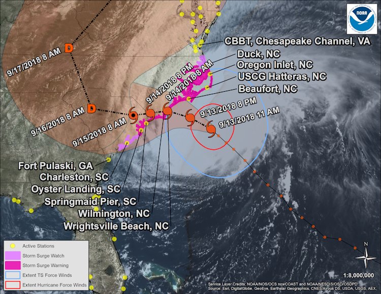
Storm surge is expected to peak at levels of 9 to 13 ft from Cape Fear all the way to Cape Lookout. Though there are no official reports of storm surge, waters are rising rapidly on the coast. If you are in these areas, stay indoors & do not venture outside (especially to beach)
NC Emergency Managem
NC Emergency Managem
@NCEmergency
·
23m
Don't forget these sources for your
#HurricaneFlorence
updates:
- (link: http://ncdps.gov/florence) ncdps.gov/florence (includes helpful links, shelter list, evacuation orders, etc.)
- The ReadyNC app
- NC Emergency Management Facebook & Twitter feeds
Need assistance? Text "Florence" to 898211 for assistance. You can also call 2-1-1 to speak to a specialist
@NCEmergency
·
3m
Storm surge is expected to peak at levels of 9 to 13 ft from Cape Fear all the way to Cape Lookout. Though there are no official reports of storm surge, waters are rising rapidly on the coast. If you are in these areas, stay indoors & do not venture outside (especially to beach)
NC Emergency Managem
NC Emergency Managem
@NCEmergency
·
23m
Don't forget these sources for your
#HurricaneFlorence
updates:
- (link: http://ncdps.gov/florence) ncdps.gov/florence (includes helpful links, shelter list, evacuation orders, etc.)
- The ReadyNC app
- NC Emergency Management Facebook & Twitter feeds
Need assistance? Text "Florence" to 898211 for assistance. You can also call 2-1-1 to speak to a specialist
0 likes
Re: ATL: FLORENCE - Evacuations, Closings, Webcams, Observations
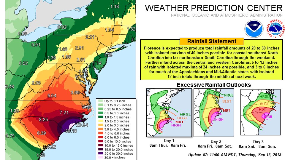
Hurricane Florence Tropical Cyclone Update...Corrected
NWS National Hurricane Center Miami FL AL062018
100 PM EDT Thu Sep 13 2018
Corrected issuance time to 100 PM EDT
...WINDS AND SURF INCREASING ALONG THE OUTER BANKS AND COASTAL
SOUTHEASTERN NORTH CAROLINA...
...LIFE-THREATENING STORM SURGE AND RAINFALL EXPECTED...
...TORNADO THREAT INCREASING AS FLORENCE MOVES CLOSER...
A NOAA reporting station at Cape Lookout, North Carolina, recently
reported a sustained wind of 45 mph...72 km/h and a gust to 54 mph
...87 km/h. A Weatherflow private observing station in Pamlico
Sound, North Carolina, recently reported a sustained wind of 51
mph...82 km/h and a gust to 61 mph...98 km/h.
0 likes
Re: ATL: FLORENCE - Evacuations, Closings, Webcams, Observations
High tides per nws twitter
NOAA's Ocean Service
@noaaocean
·
14m
High tide over the next 2-3 days will occur around noon and midnight in the SE. That is when most places on the coast will likely see the highest water levels from
#Florence
. Keep up to date with water levels here: (link: https://tidesandcurrents.noaa.gov/quick ... e=Florence) tidesandcurrents.noaa.gov/quicklook/view…
0 likes
Re: ATL: FLORENCE - Evacuations, Closings, Webcams, Observations
Log in
Sign up
Natl Hurricane Ctr
Follow
Natl Hurricane Ctr
@NWSNHC
Official Twitter account for the National Weather Service's National Hurricane Center. Details: (link: http://weather.gov/twitter) weather.gov/twitter
Miami, FLhurricanes.gov
61 Following
148.3K Followers
Tweets
Tweets & replies
Media
Likes
Natl Hurricane Ctr’s Tweets
Natl Hurricane Ctr
Natl Hurricane Ctr
@NWSNHC
·
9m
NHC Director Ken Graham will provide a Facebook Live broadcast at 2:10 p.m. EDT with the latest information regarding Hurricane
#Florence
(link: http://www.facebook.com/NWSNHC) facebook.com/NWSNHC
@NOAA
@NWS
#HurricanePrep
0 likes
Re: ATL: FLORENCE - Evacuations, Closings, Webcams, Observations
SCDOT
SCDOT
@SCDOTPress
·
49m
The lane reversal has ended on U.S. 501 out of Myrtle Beach. SCDOT crews are removing cones and barrels prior to the storm hitting. (Photos by District 5)
SCDOT
@SCDOTPress
·
49m
The lane reversal has ended on U.S. 501 out of Myrtle Beach. SCDOT crews are removing cones and barrels prior to the storm hitting. (Photos by District 5)
0 likes
Re: ATL: FLORENCE - Evacuations, Closings, Webcams, Observations
SCOP
SCOP
@SCOP_HLS_EMA
Over 250 ambulances from AR, MS, and TN standing by at the Spartanburg Airport await Florence. Stay safe friends!

SCOP
@SCOP_HLS_EMA
Over 250 ambulances from AR, MS, and TN standing by at the Spartanburg Airport await Florence. Stay safe friends!
0 likes
Re: ATL: FLORENCE - Evacuations, Closings, Webcams, Observations
Tim Pulliam
@TimABC11
·
11m
Shelters are now open in Wayne County ahead of
#Florence
. Additional shelters are opening soon as these expect to reach capacity. Carver Elementary is full with 250 people hunkering down inside.
#HurricaneFlorence
#FlorenceNC
#NCwx
#ABC11
#FloodProneArea
#ABC11
@TimABC11
·
11m
Shelters are now open in Wayne County ahead of
#Florence
. Additional shelters are opening soon as these expect to reach capacity. Carver Elementary is full with 250 people hunkering down inside.
#HurricaneFlorence
#FlorenceNC
#NCwx
#ABC11
#FloodProneArea
#ABC11
0 likes
Re: ATL: FLORENCE - Evacuations, Closings, Webcams, Observations
SCEMD Retweeted
SC Governor Press
SC Governor Press
@scgovernorpress
·
1h
Governor Henry McMaster will hold a media briefing with state emergency response officials today, Thursday, September 13 at 2:30 PM. The governor will update the public on Hurricane Florence's potential impact to South Carolina. Watch live via
@SCET
SC Governor Press
SC Governor Press
@scgovernorpress
·
1h
Governor Henry McMaster will hold a media briefing with state emergency response officials today, Thursday, September 13 at 2:30 PM. The governor will update the public on Hurricane Florence's potential impact to South Carolina. Watch live via
@SCET
0 likes
Re: ATL: FLORENCE - Evacuations, Closings, Webcams, Observations
NHC_Surge Retweeted
National Hurricane Center
National Hurricane Center
@NHC_Atlantic
·
2h
A life-threatening storm surge is expected from
#Florence
, particularly along the North Carolina coast between Cape Fear and Cape Lookout, including western Pamlico Sound and the Pamlico and Neuse Rivers. Water levels are already quickly rising in these areas
@NHC_Surge
National Hurricane Center
National Hurricane Center
@NHC_Atlantic
·
2h
A life-threatening storm surge is expected from
#Florence
, particularly along the North Carolina coast between Cape Fear and Cape Lookout, including western Pamlico Sound and the Pamlico and Neuse Rivers. Water levels are already quickly rising in these areas
@NHC_Surge
0 likes
Re: ATL: FLORENCE - Evacuations, Closings, Webcams, Observations
Petplan Insurance
Petplan Insurance
@Petplan
·
17m
Wake County NC opening three new shelters to help local residents deal with the impending arrival of
#HurricaneFlorence
1 p.m. at Heritage High School
2:30 p.m. at Middle Creek High School
4 p.m. at Sanderson High School
The Heritage shelter is pet friendly.
Petplan Insurance
@Petplan
·
17m
Wake County NC opening three new shelters to help local residents deal with the impending arrival of
#HurricaneFlorence
1 p.m. at Heritage High School
2:30 p.m. at Middle Creek High School
4 p.m. at Sanderson High School
The Heritage shelter is pet friendly.
0 likes
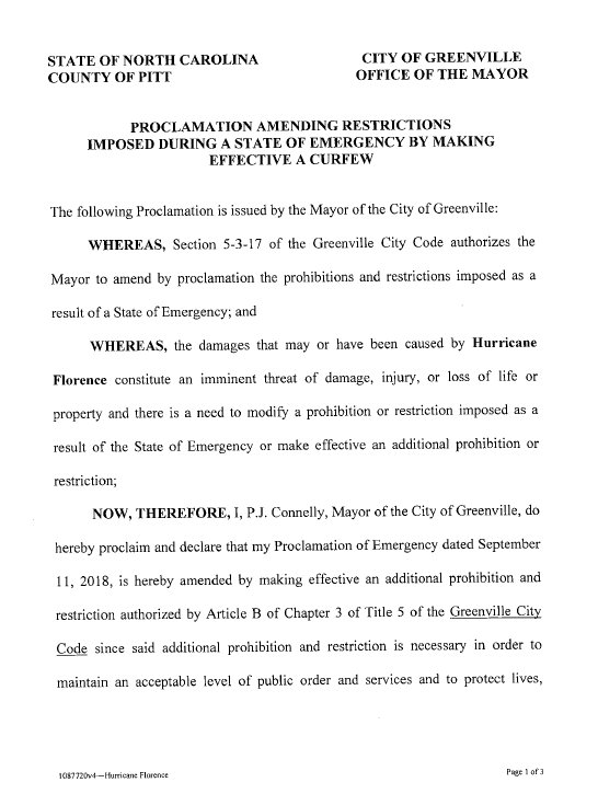
Re: ATL: FLORENCE - Evacuations, Closings, Webcams, Observations
City of Greenville
@GreenvilleGov
·
14m
SAND BAGS: The City of Greenville is no longer providing sand to fill sand bags. Thank you to all who came out ahead of
#HurricaneFlorence
to help their fellow citizens.
@GreenvilleGov
·
14m
SAND BAGS: The City of Greenville is no longer providing sand to fill sand bags. Thank you to all who came out ahead of
#HurricaneFlorence
to help their fellow citizens.
0 likes
Re: ATL: FLORENCE - Evacuations, Closings, Webcams, Observations
NCI Emergency Management
NCI Emergency Management
@ReadyNCI
·
17m
We learned our lesson the hard way last year regarding leaving furniture outside during strong winds.
Watch just to the right of center in this GIF & don't forget to move any unsecured items inside before
#HurricaneFlorence
https://mobile.twitter.com/ReadyNCI/sta ... 8854842369
Video at link of what happened as it happened
0 likes
Re: ATL: FLORENCE - Evacuations, Closings, Webcams, Observations
Tweets & replies
Media
Likes
Dr. Rick Knabb’s Tweets
Dr. Rick Knabb Retweeted
SCETV
SCETV
@SCETV
·
16m
Highway 501 is no longer reversed. I26 will no longer be reversed as of 6 PM.
#HurricaneFlorence
#scwx
Media
Likes
Dr. Rick Knabb’s Tweets
Dr. Rick Knabb Retweeted
SCETV
SCETV
@SCETV
·
16m
Highway 501 is no longer reversed. I26 will no longer be reversed as of 6 PM.
#HurricaneFlorence
#scwx
0 likes
Re: ATL: FLORENCE - Evacuations, Closings, Webcams, Observations
Anyone in the areas effected, if you have any observations or news, please share it here.
0 likes

Re: ATL: FLORENCE - Evacuations, Closings, Webcams, Observations
Does anyone have any good links to live webcams along the coast?
0 likes
Who is online
Users browsing this forum: No registered users and 139 guests