ATL: FLORENCE - Post-Tropical - Discussion

Moderator: S2k Moderators

Message
Author
User avatar
CronkPSU
S2K Supporter
S2K Supporter
Posts: 1900
Joined: Sun Aug 07, 2005 10:44 pm
Location: Avalon Park, FL

Re: ATL: FLORENCE - Hurricane - Discussion

#4821 Postby CronkPSU » Fri Sep 14, 2018 2:48 pm

hurricaneCW wrote:
jlauderdal wrote:another person has died plugging in a generator


The media has given this the all clear yet the worst effects are just unfolding. Widespread record river crests are likely by next week.


Same thing happened wIth Katrina...media making all these miracle saves New Orleans stories because of seeing Bourbon Street was spared
2 likes   
Just like Jon Snow..."I know nothing" except what I know, and most of what I know is gathered by the fine people of the NHC

jlauderdal
S2K Supporter
S2K Supporter
Posts: 6771
Joined: Wed May 19, 2004 5:46 am
Location: NE Fort Lauderdale
Contact:

Re: ATL: FLORENCE - Hurricane - Discussion

#4822 Postby jlauderdal » Fri Sep 14, 2018 2:50 pm

SEASON_CANCELED wrote:
jlauderdal wrote:
hurricaneCW wrote:
The media has given this the all clear yet the worst effects are just unfolding. Widespread record river crests are likely by next week.
I hear you, i ranted earlier,so far no deaths from people out sightseeing but maybe tonight in flood waters, hopefully I am wrong

TWC just showed some people walking around New Bern in flood waters, they werent evacuating just walking around barefoot :roll:

full disclosure: i drove up 95 with a friend during frances, we made it as far as Palm Beach, i dont drive around in storms anymore as we were almost hit by a flying stop sign


I hear yah. My friends and I Drove smoking green during hurricane charley. They sent a message... all the cops went in and would not respond to calls. We were going backwards and went the wrong way up an offramp on I75. nobody around. good times till we got a flat tire and we had to call my dad who came and got us and whooped my ass


Yep, we were both younger back in those days, lol. Driving around in anything above 50 is too much work and stress.
0 likes   

User avatar
PTPatrick
Category 5
Category 5
Posts: 1827
Joined: Sat Jun 12, 2004 8:38 am

Re: ATL: FLORENCE - Hurricane - Discussion

#4823 Postby PTPatrick » Fri Sep 14, 2018 2:53 pm

SEASON_CANCELED wrote:
Hurricane Andrew wrote:Outage Update - 1900z
North Carolina: 624,597
South Carolina: 86,019

We're over 700K...


Still a pretty small area affected...Irma knocked out 7 million. We did not get power back on for 3 weeks. That sucks in the florida heat.


Yeah I would imagine you’d have more outage if had swept thru quickly to Raleigh. But the area is not as densely populated in the way Florida is. And the way it moved it really kept much of the heaviest wind at the coastline. Rain doesn’t often take power until there is major flooding of substations and such. I would be interested to see the percentage of power loss in the coastal counties. I would bet it’s quite high from morehead south. It also depends heavily on infrastructure. Areas that have had hits in some recent years tend to have more resilient and resistant infrastructure.

Found the answer : duke energy has 100% in the at least 5 coastal counties (new Bern, Jacksonville, and Wilmington) some 60 in most other counties and even 30 % pushing closer to raliegh
Last edited by PTPatrick on Fri Sep 14, 2018 3:03 pm, edited 1 time in total.
1 likes   

jlauderdal
S2K Supporter
S2K Supporter
Posts: 6771
Joined: Wed May 19, 2004 5:46 am
Location: NE Fort Lauderdale
Contact:

Re: ATL: FLORENCE - Hurricane - Discussion

#4824 Postby jlauderdal » Fri Sep 14, 2018 2:53 pm

CronkPSU wrote:
hurricaneCW wrote:
jlauderdal wrote:another person has died plugging in a generator


The media has given this the all clear yet the worst effects are just unfolding. Widespread record river crests are likely by next week.


Same thing happened wIth Katrina...media making all these miracle saves New Orleans stories because of seeing Bourbon Street was spared
The media people standing in an exposed parking lot are in real jeopardy of getting hit by debris, I am really surprised for their own safety they do it, its one thing to stand in a parking garage or around the corner of a building away from the wind to show it but to stand their completely exposed is pointless and sends the wrong message completely.
3 likes   

User avatar
Kingarabian
S2K Supporter
S2K Supporter
Posts: 15432
Joined: Sat Aug 08, 2009 3:06 am
Location: Honolulu, Hawaii

Re: ATL: FLORENCE - Hurricane - Discussion

#4825 Postby Kingarabian » Fri Sep 14, 2018 3:04 pm

Just got word from some relatives that their house got blown over. Thankfully they evacuated. Damn.
2 likes   
RIP Kobe Bryant

Jelff
Tropical Depression
Tropical Depression
Posts: 50
Joined: Tue Aug 29, 2017 3:04 pm
Contact:

Re: ATL: FLORENCE - Hurricane - Discussion

#4826 Postby Jelff » Fri Sep 14, 2018 3:08 pm

The link below will open an online map that can display various overlays of authoritative data that are hosted on government GIS (Geographical Information System) servers.

When the map opens it displays an overlay showing stream gages. As water levels rise, the color of the gage changes. Red = highest water. Each time you open the map you will see the most recent data (i.e. updated gage colors) from NOAA’s server.

If you click a gage and follow the link, then you will see the official NOAA data page for that stream gage. The gage at Wilmington is about to set a record.

Only the top overlay is clickable. Don't know what that means? Please take a moment and read the "Map tips". That link is in the upper left corner.

The map is displayed by GISsurfer which is based on the free open-source Leaflet API (Application Program Interface). GISsurfer replaces Gmap4 which was an earlier web map I developed that was based on the Google map API. This past spring Google radically slashed the amount of free API usage it allowed. Audios Google.

Open online map:
https://mappingsupport.com/p2/gissurfer ... ricane.txt
3 likes   

jlauderdal
S2K Supporter
S2K Supporter
Posts: 6771
Joined: Wed May 19, 2004 5:46 am
Location: NE Fort Lauderdale
Contact:

Re: ATL: FLORENCE - Hurricane - Discussion

#4827 Postby jlauderdal » Fri Sep 14, 2018 3:10 pm

Kingarabian wrote:Just got word from some relatives that their house got blown over. Thankfully they evacuated. Damn.
where was that, takes some big winds to blow a house over
0 likes   

User avatar
Kingarabian
S2K Supporter
S2K Supporter
Posts: 15432
Joined: Sat Aug 08, 2009 3:06 am
Location: Honolulu, Hawaii

Re: ATL: FLORENCE - Hurricane - Discussion

#4828 Postby Kingarabian » Fri Sep 14, 2018 3:12 pm

jlauderdal wrote:
Kingarabian wrote:Just got word from some relatives that their house got blown over. Thankfully they evacuated. Damn.
where was that, takes some big winds to blow a house over


Holly Ridge town
0 likes   
RIP Kobe Bryant

User avatar
NC George
Category 2
Category 2
Posts: 624
Age: 54
Joined: Sun Sep 14, 2003 11:44 am
Location: Washington, NC, USA

Re: ATL: FLORENCE - Hurricane - Discussion

#4829 Postby NC George » Fri Sep 14, 2018 3:18 pm

Sanibel wrote:I wonder if that poster from Greenville is still saying it is a dud?...Amazing storm still feeding off the Gulf Stream...


For us, it was/is, and we really got lucky, likely due to the quite unusual track this hurricane took as compared to the typical from the S direction. I'm only reporting conditions for my city, and not the storm in general. As I noted, it was much worse than probably anybody anticipated in the New Bern to Morehead City area, and flooding may end up being worse than it was in Matthew in the areas south of us into SC. As to our city, we prepared. Most businesses are still closed. Schools closed for the week There was a massive cleanup of all yards to counter flying debris.

As for local conditions, it's been raining steadily since this morning. We're up to 5 inches of rain, and the Tar River has risen 6' to total of 11', still a couple of feet from flood stage, and seems to be leveling off. Pressure is rising slightly to 1013 millibars.
0 likes   
Bertha '96, Fran '96, Bonnie '98, Dennis '99, Floyd '99 :eek: , Isabel '03, Irene '11, Matthew '16, Isaias '20, PTC16????

Avatar is heading into Florence 2018, moving friend's boat, only land between us and Hurricane Florence is Ocracoke Island!

Sciencerocks
Category 5
Category 5
Posts: 7282
Age: 38
Joined: Thu Jul 06, 2017 1:51 am

Re: ATL: FLORENCE - Hurricane - Discussion

#4830 Postby Sciencerocks » Fri Sep 14, 2018 3:26 pm

Image

Image

Image
4 likes   

User avatar
Nimbus
Category 5
Category 5
Posts: 4928
Joined: Mon Jul 19, 2004 10:54 am

Re: ATL: FLORENCE - Hurricane - Discussion

#4831 Postby Nimbus » Fri Sep 14, 2018 3:30 pm

SEASON_CANCELED wrote:
Hurricane Andrew wrote:Outage Update - 1900z
North Carolina: 624,597
South Carolina: 86,019

We're over 700K...


Still a pretty small area affected...Irma knocked out 7 million. We did not get power back on for 3 weeks. That sucks in the florida heat.


Over 55,000 reported outages way up near Raleigh alone, so their reporting system may be overloaded..
1 likes   

ChucktownStormer
Tropical Low
Tropical Low
Posts: 15
Joined: Thu Sep 07, 2017 1:30 pm

Re: ATL: FLORENCE - Hurricane - Discussion

#4832 Postby ChucktownStormer » Fri Sep 14, 2018 3:32 pm

jlauderdal wrote:
Kingarabian wrote:Just got word from some relatives that their house got blown over. Thankfully they evacuated. Damn.
where was that, takes some big winds to blow a house over

Impossible. It was only a Category 1...
0 likes   

ronyan
S2K Supporter
S2K Supporter
Posts: 791
Age: 37
Joined: Tue Sep 09, 2008 5:46 pm
Location: Lake Jackson, TX

Re: ATL: FLORENCE - Hurricane - Discussion

#4833 Postby ronyan » Fri Sep 14, 2018 3:36 pm

ChucktownStormer wrote:
jlauderdal wrote:
Kingarabian wrote:Just got word from some relatives that their house got blown over. Thankfully they evacuated. Damn.
where was that, takes some big winds to blow a house over

Impossible. It was only a Category 1...


Well there are these things called tornados that exist.
5 likes   

User avatar
sittingduck
S2K Supporter
S2K Supporter
Posts: 107
Joined: Mon Aug 13, 2007 3:16 pm
Location: venice florida

Re: ATL: FLORENCE - Hurricane - Discussion

#4834 Postby sittingduck » Fri Sep 14, 2018 3:36 pm

Anyone heard from Aric since he went off the air last night?
0 likes   

AutoPenalti
Category 5
Category 5
Posts: 3949
Age: 27
Joined: Mon Aug 17, 2015 4:16 pm
Location: Ft. Lauderdale, Florida

Re: ATL: FLORENCE - Hurricane - Discussion

#4835 Postby AutoPenalti » Fri Sep 14, 2018 3:40 pm

sittingduck wrote:Anyone heard from Aric since he went off the air last night?

Last active: Fri Sep 14, 2018 5:06 am

According to his bio he lives in Chicago. So, unless he lives closer to the coast, he could just be sleeping in, or working or busy.
1 likes   
The posts in this forum are NOT official forecasts and should not be used as such. They are just the opinion of the poster and may or may not be backed by sound meteorological data. They are NOT endorsed by any professional institution or STORM2K. For official information, please refer to products from the NHC and NWS.


Model Runs Cheat Sheet:
GFS (5:30 AM/PM, 11:30 AM/PM)
HWRF, GFDL, UKMET, NAVGEM (6:30-8:00 AM/PM, 12:30-2:00 AM/PM)
ECMWF (1:45 AM/PM)

TCVN
is a weighted averaged

User avatar
Steve
S2K Supporter
S2K Supporter
Posts: 8605
Joined: Sat Apr 05, 2003 11:41 pm
Location: Not a state-caster

Re: ATL: FLORENCE - Hurricane - Discussion

#4836 Postby Steve » Fri Sep 14, 2018 3:44 pm

SEASON_CANCELED wrote:
hurricaneCW wrote:
jlauderdal wrote:another person has died plugging in a generator


The media has given this the all clear yet the worst effects are just unfolding. Widespread record river crests are likely by next week.


Media is stupid. CNN, ABC, Local news. Its all hype, ratings, and politics.

Every storm is the "Storm of the Century" and after awhile its like...who cares..why evacuate. Now they can go back to covering whatever stupid made up narrative they pulled out of thin air.


Without naming names and getting in trouble, you probably should have included propaganda outlets in that rant too. :)

Just the same, we all watch. Almost everyone is fascinated with the power of nature and death, doom and destruction. That’s why they show it. It’s also a legitimate ongoing story affecting our friends, relatives, loved ones and countrymen and women. I think it will help motivate many of us to action be that direct (helping with dispatch) or donating supplies or money to charitable organizations.

Cloudtops appear to be warming as they have in the mid afternoon recently. Hopefully that doesn’t mean blacks and whites are going to show up closer to dark and particularly late night like the did last night. Some have speculated that was in part due to land interaction and the shape of the coast. Also, if Florence was to remain over land, the heating and cooling dynamics may change. We will se in about 4 hours.

https://www.tropicaltidbits.com/sat/sat ... product=ir
Last edited by Steve on Fri Sep 14, 2018 3:45 pm, edited 1 time in total.
2 likes   

User avatar
sittingduck
S2K Supporter
S2K Supporter
Posts: 107
Joined: Mon Aug 13, 2007 3:16 pm
Location: venice florida

Re: ATL: FLORENCE - Hurricane - Discussion

#4837 Postby sittingduck » Fri Sep 14, 2018 3:45 pm

AutoPenalti wrote:
sittingduck wrote:Anyone heard from Aric since he went off the air last night?

Last active: Fri Sep 14, 2018 5:06 am

According to his bio he lives in Chicago. So, unless he lives closer to the coast, so could just be sleeping in, or working or busy.

He was broadcasting live from a parking garage in Wilmington last night when the eyeball went through. But thanks at least I know he was on here at o dark thirty lol
2 likes   

AutoPenalti
Category 5
Category 5
Posts: 3949
Age: 27
Joined: Mon Aug 17, 2015 4:16 pm
Location: Ft. Lauderdale, Florida

Re: ATL: FLORENCE - Hurricane - Discussion

#4838 Postby AutoPenalti » Fri Sep 14, 2018 3:46 pm

sittingduck wrote:
AutoPenalti wrote:
sittingduck wrote:Anyone heard from Aric since he went off the air last night?

Last active: Fri Sep 14, 2018 5:06 am

According to his bio he lives in Chicago. So, unless he lives closer to the coast, so could just be sleeping in, or working or busy.

He was broadcasting live from a parking garage in Wilmington last night when the eyeball went through. But thanks at least I know he was on here at o dark thirty lol

Oh wow, I didn't notice he was streaming. Was there a link?
0 likes   
The posts in this forum are NOT official forecasts and should not be used as such. They are just the opinion of the poster and may or may not be backed by sound meteorological data. They are NOT endorsed by any professional institution or STORM2K. For official information, please refer to products from the NHC and NWS.


Model Runs Cheat Sheet:
GFS (5:30 AM/PM, 11:30 AM/PM)
HWRF, GFDL, UKMET, NAVGEM (6:30-8:00 AM/PM, 12:30-2:00 AM/PM)
ECMWF (1:45 AM/PM)

TCVN
is a weighted averaged

User avatar
sittingduck
S2K Supporter
S2K Supporter
Posts: 107
Joined: Mon Aug 13, 2007 3:16 pm
Location: venice florida

Re: ATL: FLORENCE - Hurricane - Discussion

#4839 Postby sittingduck » Fri Sep 14, 2018 3:48 pm

AutoPenalti wrote:
sittingduck wrote:
AutoPenalti wrote:Last active: Fri Sep 14, 2018 5:06 am

According to his bio he lives in Chicago. So, unless he lives closer to the coast, so could just be sleeping in, or working or busy.

He was broadcasting live from a parking garage in Wilmington last night when the eyeball went through. But thanks at least I know he was on here at o dark thirty lol

Yep. I watched until he went off the air which was maybe an hour or so before he would have been in the eye.
Oh wow, I didn't notice he was streaming. Was there a link?
0 likes   

User avatar
cycloneye
Admin
Admin
Posts: 139025
Age: 67
Joined: Thu Oct 10, 2002 10:54 am
Location: San Juan, Puerto Rico

Re: ATL: FLORENCE - Advisories

#4840 Postby cycloneye » Fri Sep 14, 2018 3:50 pm

BULLETIN
Tropical Storm Florence Advisory Number 62
NWS National Hurricane Center Miami FL AL062018
500 PM EDT Fri Sep 14 2018

...FLORENCE NOW PRODUCING TROPICAL-STORM-FORCE WIND GUSTS IN
FLORENCE SOUTH CAROLINA...
...LIFE-THREATENING STORM SURGES TO CONTINUE TONIGHT...
...CATASTROPHIC FRESHWATER FLOODING EXPECTED OVER PORTIONS OF NORTH
AND SOUTH CAROLINA...


SUMMARY OF 500 PM EDT...2100 UTC...INFORMATION
----------------------------------------------
LOCATION...34.0N 78.6W
ABOUT 50 MI...75 KM WSW OF WILMINGTON NORTH CAROLINA
ABOUT 25 MI...45 KM NE OF MYRTLE BEACH SOUTH CAROLINA
MAXIMUM SUSTAINED WINDS...70 MPH...110 KM/H
PRESENT MOVEMENT...W OR 270 DEGREES AT 3 MPH...6 KM/H
MINIMUM CENTRAL PRESSURE...972 MB...28.70 INCHES


WATCHES AND WARNINGS
--------------------
CHANGES WITH THIS ADVISORY:

The Storm Surge Warning has been discontinued south of Myrtle
Beach, South Carolina, and north of Salvo, North Carolina,
including Albemarle Sound.

The Storm Surge Watch has been discontinued.

The Hurricane Warning has been replaced with a Tropical Storm
Warning from South Santee River, South Carolina to Cape Hatteras,
North Carolina.

The Tropical Storm Warning has been discontinued north of Cape
Hatteras, including Albemarle Sound.

The Hurricane Watch has been discontinued.

SUMMARY OF WATCHES AND WARNINGS IN EFFECT:

A Storm Surge Warning is in effect for...
* Myrtle Beach South Carolina to Salvo North Carolina
* Pamlico Sound, including the Neuse and Pamlico Rivers

A Tropical Storm Warning is in effect for...
* Edisto Beach South Carolina to Cape Hatteras North Carolina
* Pamlico Sound

Interests elsewhere in the southeastern and mid-Atlantic states
should monitor the progress of Florence.

For storm information specific to your area, including possible
inland watches and warnings, please monitor products issued by your
local National Weather Service forecast office.


DISCUSSION AND OUTLOOK
----------------------
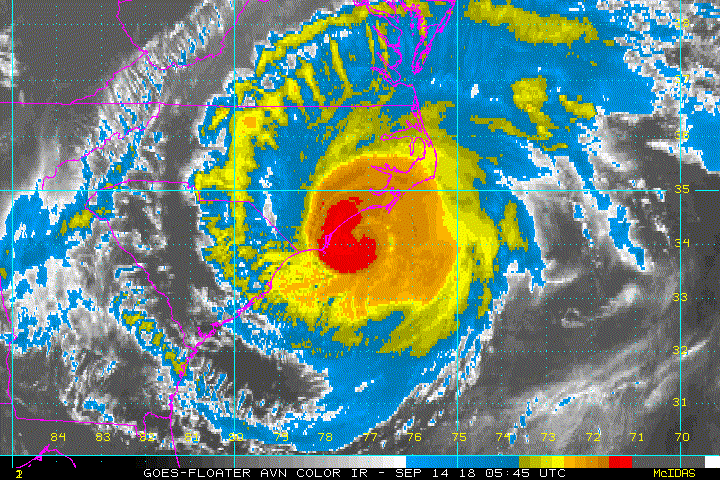
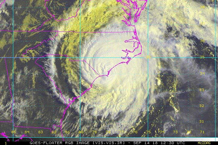
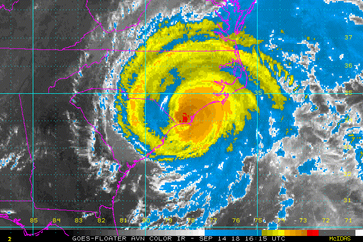
At 500 PM EDT (2100 UTC), the center of Tropical Storm Florence was
located near latitude 34.0 North, longitude 78.6 West. Florence is
moving toward the west near 3 mph (6 km/h). A slow westward to
west-southwestward motion is expected through Saturday. On the
forecast track, the center of Florence will move farther inland
across extreme southeastern North Carolina this evening, and across
extreme eastern South Carolina tonight and Saturday. Florence will
then move generally northward across the western Carolinas and the
central Appalachian Mountains early next week.

Doppler radar data and surface observations indicate that maximum
sustained winds have decreased near 70 mph (110 km/h) with higher
gusts. Gradual weakening is expected tonight. Significant weakening
is forecast over the weekend and into early next week while Florence
moves farther inland.

Tropical-storm-force winds extend outward up to 175 miles (280 km)
from the center. A sustained wind of 55 mph (89 km/h) and gust to
to 72 mph (116 km/h) was recently reported at the National Ocean
Service station at Johnny Mercer Pier in Wrightsville Beach.

The estimated minimum central pressure based on nearby surface
observations is 972 mb (28.70 inches).


HAZARDS AFFECTING LAND
----------------------
STORM SURGE: The combination of a dangerous storm surge and the
tide will cause normally dry areas near the coast to be flooded by
rising waters moving inland from the shoreline. The water has the
potential to reach the following heights above ground...

The Neuse, Pamlico, Pungo, and Bay Rivers...8-12 ft
Cape Fear NC to Salvo NC...3-5 ft
Myrtle Beach SC to Cape Fear NC...2-4 ft

The deepest water will occur along the immediate coast in areas of
onshore winds, where the surge will be accompanied by large and
destructive waves. Surge-related flooding can vary greatly over
short distances. For information specific to your area, please see
products issued by your local National Weather Service forecast
office.

RAINFALL: Florence is expected to produce heavy and excessive
rainfall in the following areas...

Southeastern coastal North Carolina into far northeastern South
Carolina...an additional 20 to 25 inches, with isolated storm totals
of 30 to 40 inches. This rainfall will produce catastrophic flash
flooding and prolonged significant river flooding.

Remainder of South Carolina and North Carolina into southwest
Virginia...5 to 10 inches, isolated 15 inches. This rainfall will
produce life-threatening flash flooding.

Rainfall totals exceeding 16 inches thus far have been reported at
several locations across southeastern North Carolina.

WIND: Tropical storm conditions will continue through Saturday
morning in portions of the warning area along the coast and also
over large portions of eastern North Carolina and extreme eastern
South Carolina, with tropical storm force wind gusts spreading well
inland.

TORNADOES: A few tornadoes are possible in eastern North Carolina
through tonight, mainly near southeast coastal areas after dark.

SURF: Swells generated by Florence are affecting Bermuda, portions
of the U.S. East Coast, and the northwestern and central Bahamas.
These swells are likely to cause life-threatening surf and rip
current conditions. Please consult products from your local weather
office.


NEXT ADVISORY
-------------
Next intermediate advisory at 800 PM EDT.
Next complete advisory at 1100 PM EDT.

$$
Forecaster Stewart
0 likes   
Visit the Caribbean-Central America Weather Thread where you can find at first post web cams,radars
and observations from Caribbean basin members Click Here


Return to “2018”

Who is online

Users browsing this forum: No registered users and 20 guests