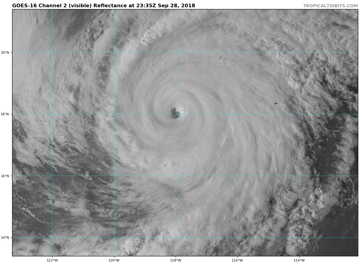
EPAC: ROSA - Post-Tropical

Moderator: S2k Moderators

Message
Author
User avatar
NDG
S2K Supporter
S2K Supporter
Posts: 14933
Joined: Sun Jul 09, 2006 10:14 pm
Location: Orlando, FL

Re: EPAC: ROSA - Hurricane

#101 Postby NDG » Fri Sep 28, 2018 2:39 pm

supercane4867 wrote:EWRC is near completion. Here comes the large eye contest between Rosa and Trami

https://i.imgur.com/GPtolQb.jpg

https://i.imgur.com/4czjwhS.jpg


The difference is that Trami is over deeper warm waters than where Rosa is, not sure if Rosa will have time to put up a large eye like Trami in time, btw the microwave image of Rosa is over 5 hours old.

Edit: T numbers down to 4.5/5.5, barely a major hurricane now.
1 likes   

Ntxw
Storm2k Moderator
Storm2k Moderator
Posts: 21490
Joined: Wed Oct 21, 2009 6:34 pm
Location: DFW, Texas

Re: EPAC: ROSA - Hurricane

#102 Postby Ntxw » Fri Sep 28, 2018 3:11 pm

Looks like it will be 105kts
0 likes   
The above post and any post by Ntxw is NOT an official forecast and should not be used as such. It is just the opinion of the poster and may or may not be backed by sound meteorological data. It is NOT endorsed by any professional institution including Storm2k. For official information, please refer to NWS products.

  Help support Storm2K!
Help Support Storm2K

Ntxw
Storm2k Moderator
Storm2k Moderator
Posts: 21490
Joined: Wed Oct 21, 2009 6:34 pm
Location: DFW, Texas

Re: EPAC: ROSA - Hurricane

#103 Postby Ntxw » Fri Sep 28, 2018 6:57 pm

Image
3 likes   
The above post and any post by Ntxw is NOT an official forecast and should not be used as such. It is just the opinion of the poster and may or may not be backed by sound meteorological data. It is NOT endorsed by any professional institution including Storm2k. For official information, please refer to NWS products.


  Help support Storm2K!

Help Support Storm2K


User avatar
cycloneye
Admin
Admin
Posts: 139008
Age: 67
Joined: Thu Oct 10, 2002 10:54 am
Location: San Juan, Puerto Rico

Re: EPAC: ROSA - Hurricane

#104 Postby cycloneye » Fri Sep 28, 2018 9:45 pm

Hurricane Rosa Discussion Number 16
NWS National Hurricane Center Miami FL EP202018
800 PM PDT Fri Sep 28 2018

The satellite appearance of Rosa continues to degrade due to an
ongoing eyewall cycle with weaker convection noted near the
eyewall and an apparent moat region. Dvorak estimates continue to
fall, and a blend from all agencies gives 95 kt as an initial wind
speed. Continued weakening is in the forecast while Rosa moves
across progressively cooler SSTs into a higher shear and drier
environment. There is some chance that the weakening could pause if
the eyewall cycle finishes, but that's less likely as the cyclone
encounters the less favorable environment. Thus Rosa is forecast to
continue to gradually weaken until it approaches Baja California as
a tropical storm. The intensity guidance is in good agreement on
this scenario, and the new NHC prediction is basically an update of
the previous one after accounting for the initial winds.

Rosa has turned to the north-northwest and accelerated, with an
initial motion of 340/8. The cyclone should turn to the north
tomorrow and move faster to the north-northeast on Sunday ahead of a
mid- to upper-level trough approaching the west coast of the United
States. There are no substantial guidance changes to consider, and
with the model consensus being quite reliable so far, it makes
sense to stay near that aid, which is also very close to the
previous forecast.

Key Messages:

1. The main hazard expected from Rosa or its remnants is very heavy
rainfall in Baja California, northwestern Mexico and the Desert
Southwest. These rains are expected to produce life-threatening
flash flooding and debris flows in the deserts and landslides in
mountainous terrain. For more information about potential rainfall
in that area, please see products from the Weather Prediction Center
and your local NWS forecast office.

2. Rosa could also bring tropical storm conditions to portions of
the central and northern Baja California peninsula in a few days.
Interests in those locations should monitor the progress of Rosa.


FORECAST POSITIONS AND MAX WINDS

INIT 29/0300Z 18.4N 118.0W 95 KT 110 MPH
12H 29/1200Z 19.5N 118.4W 85 KT 100 MPH
24H 30/0000Z 21.4N 118.8W 75 KT 85 MPH
36H 30/1200Z 23.3N 118.6W 65 KT 75 MPH
48H 01/0000Z 25.1N 117.9W 55 KT 65 MPH
72H 02/0000Z 28.9N 116.1W 40 KT 45 MPH
96H 03/0000Z 36.0N 112.0W 15 KT 15 MPH...POST-TROP/REMNT LOW
120H 04/0000Z...DISSIPATED

$$
Forecaster Blake
0 likes   
Visit the Caribbean-Central America Weather Thread where you can find at first post web cams,radars
and observations from Caribbean basin members Click Here

User avatar
storm_in_a_teacup
Category 1
Category 1
Posts: 347
Joined: Wed Aug 16, 2017 5:01 pm
Location: Huntsville, Alabama
Contact:

Re: EPAC: ROSA - Hurricane

#105 Postby storm_in_a_teacup » Fri Sep 28, 2018 11:12 pm

CaliforniaResident wrote:
CrazyC83 wrote:If this were to threaten the California coast as a TC, I am sure they would do 6-hourly Recon missions.


We literally haven't had rainfall accumulation since early May, so bring it on!


Just so long as there’s no mudslides...
1 likes   
I know I can't straddle the atmosphere...just a tiny storm in your teacup, girl.

HurricaneRyan
Category 2
Category 2
Posts: 712
Age: 30
Joined: Sun Dec 05, 2010 3:05 pm

Re: EPAC: ROSA - Hurricane

#106 Postby HurricaneRyan » Fri Sep 28, 2018 11:15 pm

a decent rainy day would be fine with me. It's crazy how Southern California is still so warm going into October.
1 likes   
Kay '22 Hilary '23

zeehag
Tropical Storm
Tropical Storm
Posts: 172
Age: 75
Joined: Sun Jul 17, 2011 9:49 pm
Location: mazatlan,sinaloa, mexico, fixing patricia's mess.
Contact:

Re: EPAC: ROSA - Hurricane

#107 Postby zeehag » Sat Sep 29, 2018 8:22 am

we are getting poured on by rain here in mazatlan, under a band of rosa... wet wet wet one. glad i took in my sheets by the light of lightning and tympanic symphony at 0610.
saw pix of cabo san lucas flooded by bands of rosa yesterday.. rosa off shore but bands do wet us down nicely.
this is a nice wet storm.
2 likes   
life is an adventure meant to be LIVED!!!

http://www.sksolitarybird.org

User avatar
cycloneye
Admin
Admin
Posts: 139008
Age: 67
Joined: Thu Oct 10, 2002 10:54 am
Location: San Juan, Puerto Rico

Re: EPAC: ROSA - Hurricane

#108 Postby cycloneye » Sat Sep 29, 2018 9:50 am

Hurricane Rosa Discussion Number 18
NWS National Hurricane Center Miami FL EP202018
800 AM PDT Sat Sep 29 2018

Rosa has become significantly better organized during the last
several hours, likely due to the completion of an eyewall
replacement cycle before the center moved over cold water. The
storm now has a 30-40 n mi wide eye, and the eyewall convective tops
have become much colder and more symmetric. The initial intensity
has been increased to 90 kt based on a blend of various satellite
intensity estimates, and it is possible that this intensity is
conservative. The hurricane has good to excellent cirrus outflow in
the northeastern semicircle.

The current re-intensification was poorly anticipated, and it is
unclear how much more strengthening will occur before Rosa reaches
the 26C isotherm in about 12 h. Even if the hurricane strengthens
a little more, the combination of decreasing sea surface
temperatures and increasing shear should cause steady to rapid
weakening after 12 h, and the new intensity forecast still calls for
the cyclone to weaken below hurricane strength before the center
reaches the Baja California peninsula between 48-72 h. After
landfall, Rosa is expected to weaken even faster, and the surface
circulation is forecast to dissipate just after 72 h in agreement
with all of the dynamical models. However, the mid-level
circulation and the associated rainfall will continue moving across
the southwestern United States after the surface circulation
dissipates.

The initial motion is now 355/10. During the forecast period, the
hurricane will recurve into the westerlies between a deep-layer
ridge over northern Mexico and a large mid- to upper-level trough
over California and the adjacent Pacific. This should result in a
continued northward motion through tonight, followed by a turn
toward the north-northeast on Sunday. The new forecast track is
similar to, but a little faster than, the previous track and lies
near the consensus models. On the forecast track, the center of
Rosa will move near or over the central and northern portions the
Baja California peninsula on Monday and Monday night, and then move
into the southwestern United States on Tuesday.


Key Messages:

1. The main hazard expected from Rosa or its remnants is very heavy
rainfall in Baja California, northwestern Mexico, and the Desert
Southwest. These rains are expected to produce life-threatening
flash flooding and debris flows in the deserts, and landslides in
mountainous terrain. For more information about potential rainfall
in that area, please see products from the Weather Prediction Center
and your local NWS forecast office.

2. Rosa could also bring tropical storm conditions to portions of
the central and northern Baja California peninsula starting on
Monday. Interests in those locations should monitor the progress of
Rosa.


FORECAST POSITIONS AND MAX WINDS

INIT 29/1500Z 20.5N 118.4W 90 KT 105 MPH
12H 30/0000Z 22.0N 118.6W 90 KT 105 MPH
24H 30/1200Z 23.9N 118.4W 75 KT 85 MPH
36H 01/0000Z 25.9N 117.6W 60 KT 70 MPH
48H 01/1200Z 27.7N 116.7W 45 KT 50 MPH
72H 02/1200Z 33.0N 114.0W 25 KT 30 MPH...INLAND
96H 03/1200Z...DISSIPATED

$$
Forecaster Beven
0 likes   
Visit the Caribbean-Central America Weather Thread where you can find at first post web cams,radars
and observations from Caribbean basin members Click Here

supercane4867
Category 5
Category 5
Posts: 4966
Joined: Wed Nov 14, 2012 10:43 am

Re: EPAC: ROSA - Hurricane

#109 Postby supercane4867 » Sat Sep 29, 2018 11:04 am

She's not done yet

Image
2 likes   

User avatar
EquusStorm
Category 5
Category 5
Posts: 1649
Age: 33
Joined: Thu Nov 07, 2013 1:04 pm
Location: Jasper, AL
Contact:

Re: EPAC: ROSA - Hurricane

#110 Postby EquusStorm » Sat Sep 29, 2018 11:21 am

That's some super impressive recovery in marginal conditions; looks almost major again. ERCs really do throw intensities for a loop.
0 likes   
Colors of lost purpose on the canvas of irrelevance

Not a meteorologist, in fact more of an idiot than anything. You should probably check with the NHC or a local NWS office for official information.

bob rulz
Category 5
Category 5
Posts: 1667
Age: 34
Joined: Sat Jan 28, 2006 7:30 pm
Location: Salt Lake City, Utah

Re: EPAC: ROSA - Hurricane

#111 Postby bob rulz » Sat Sep 29, 2018 4:05 pm

We've had no measurable precipitation up in Salt Lake City since August 24th, so this precipitation will be very very welcome. Sounds like it could be quite significant.
1 likes   

Sciencerocks
Category 5
Category 5
Posts: 7282
Age: 38
Joined: Thu Jul 06, 2017 1:51 am

Re: EPAC: ROSA - Hurricane

#112 Postby Sciencerocks » Sat Sep 29, 2018 4:30 pm

What are the odds for this to make it to the United states as a tropical storm?
1 likes   

HurricaneRyan
Category 2
Category 2
Posts: 712
Age: 30
Joined: Sun Dec 05, 2010 3:05 pm

Re: EPAC: ROSA - Hurricane

#113 Postby HurricaneRyan » Sat Sep 29, 2018 5:15 pm

Rosa is looking like Helene right now
0 likes   
Kay '22 Hilary '23

Ntxw
Storm2k Moderator
Storm2k Moderator
Posts: 21490
Joined: Wed Oct 21, 2009 6:34 pm
Location: DFW, Texas

Re: EPAC: ROSA - Hurricane

#114 Postby Ntxw » Sat Sep 29, 2018 6:31 pm

Cooler SSTs approaching. She is hanging on for dear life.

Image
2 likes   
The above post and any post by Ntxw is NOT an official forecast and should not be used as such. It is just the opinion of the poster and may or may not be backed by sound meteorological data. It is NOT endorsed by any professional institution including Storm2k. For official information, please refer to NWS products.


  Help support Storm2K!

Help Support Storm2K


User avatar
Yellow Evan
Professional-Met
Professional-Met
Posts: 15951
Age: 25
Joined: Fri Jul 15, 2011 12:48 pm
Location: Henderson, Nevada/Honolulu, HI
Contact:

Re: EPAC: ROSA - Hurricane

#115 Postby Yellow Evan » Sat Sep 29, 2018 7:25 pm

Image

Fading again but this has enough gas in the tank to make it as a weak TS assuming standard spindown rates for strong EPAC hurricanes.
0 likes   

User avatar
NDG
S2K Supporter
S2K Supporter
Posts: 14933
Joined: Sun Jul 09, 2006 10:14 pm
Location: Orlando, FL

Re: EPAC: ROSA - Hurricane

#116 Postby NDG » Sat Sep 29, 2018 10:24 pm

Might have looked better on satellite today but still had that dry slot that has not been able to get rid of.

Image
0 likes   

User avatar
cycloneye
Admin
Admin
Posts: 139008
Age: 67
Joined: Thu Oct 10, 2002 10:54 am
Location: San Juan, Puerto Rico

Re: EPAC: ROSA - Hurricane

#117 Postby cycloneye » Sun Sep 30, 2018 3:58 pm

Hurricane Rosa Discussion Number 23
NWS National Hurricane Center Miami FL EP202018
200 PM PDT Sun Sep 30 2018

An Air Force Reserve Unit Hurricane Hunter aircraft recently
investigated Rosa, and found peak 700-mb flight-level winds that
still supported minimal hurricane intensity. However, the
SFMR-observed surface winds were somewhat lower, which is not
surprising since the system has minimal deep convection and is over
24-25 deg SSTs. Given that the central pressure is still fairly
low, 982 mb, Rosa is being maintained, perhaps generously, as a
hurricane for this advisory. With increasing shear and cooler
waters ahead for the system, weakening seems inevitable. The
official intensity forecast is similar to the latest HWRF model
prediction, and shows Rosa weakening to a depression by the time it
reaches the southwest United States.

The initial motion is north-northeastward, or 025/10 kt. The track
forecast scenario remains essentially unchanged from the previous
couple of advisory packages. The flow on the eastern side of a
large mid-level trough approaching from the west should steer Rosa
on a north-northeastward track for the next couple of days. The
official track forecast is very close to the latest dynamical model
consensus.

The wind radii have been adjusted slightly based on data from a
recent ASCAT scatterometer overpass.

Key Messages:

1. The main hazard expected from Rosa or its remnants is very heavy
rainfall in Baja California, northwestern Sonora, and the U.S.
Desert Southwest. These rains are expected to produce
life-threatening flash flooding and debris flows in the deserts, and
landslides in mountainous terrain. For more information about
potential rainfall in that area, please see products from the
Weather Prediction Center and your local NWS forecast office.

2. Tropical storm conditions are expected over portions of the
central and northern Baja California peninsula on Monday, possibly
spreading to the northern Gulf of California Monday night.
Interests in those locations should monitor the progress of Rosa.


FORECAST POSITIONS AND MAX WINDS

INIT 30/2100Z 25.2N 118.1W 65 KT 75 MPH
12H 01/0600Z 26.5N 117.4W 55 KT 65 MPH
24H 01/1800Z 28.1N 116.2W 45 KT 50 MPH
36H 02/0600Z 29.9N 115.0W 40 KT 45 MPH...INLAND
48H 02/1800Z 32.3N 113.9W 30 KT 35 MPH...INLAND
72H 03/1800Z 37.0N 112.0W 20 KT 25 MPH...POST-TROP/INLAND
96H 04/1800Z...DISSIPATED

$$
Forecaster Pasch
0 likes   
Visit the Caribbean-Central America Weather Thread where you can find at first post web cams,radars
and observations from Caribbean basin members Click Here

User avatar
cycloneye
Admin
Admin
Posts: 139008
Age: 67
Joined: Thu Oct 10, 2002 10:54 am
Location: San Juan, Puerto Rico

Re: EPAC: ROSA - Tropical Storm

#118 Postby cycloneye » Sun Sep 30, 2018 8:31 pm

BULLETIN
Tropical Storm Rosa Intermediate Advisory Number 23A
NWS National Hurricane Center Miami FL EP202018
500 PM PDT Sun Sep 30 2018

...ROSA WEAKENS TO A TROPICAL STORM...
...FLOODING RAINS EXPECTED OVER PORTIONS OF NORTHWESTERN MEXICO AND
THE WESTERN UNITED STATES...


SUMMARY OF 500 PM PDT...0000 UTC...INFORMATION
----------------------------------------------
LOCATION...25.6N 118.0W
ABOUT 235 MI...380 KM SW OF PUNTA EUGENIA MEXICO
ABOUT 420 MI...675 KM SSW OF SAN FELIPE MEXICO
MAXIMUM SUSTAINED WINDS...70 MPH...110 KM/H
PRESENT MOVEMENT...NNE OR 25 DEGREES AT 12 MPH...19 KM/H
MINIMUM CENTRAL PRESSURE...985 MB...29.09 INCHES
0 likes   
Visit the Caribbean-Central America Weather Thread where you can find at first post web cams,radars
and observations from Caribbean basin members Click Here

HurricaneRyan
Category 2
Category 2
Posts: 712
Age: 30
Joined: Sun Dec 05, 2010 3:05 pm

Re: EPAC: ROSA - Post-Tropical

#119 Postby HurricaneRyan » Tue Oct 02, 2018 1:29 pm

Is Rosa's remnants supposed to be in So Cal tomorrow? There's supposed to be light rain in the forecast for my city
0 likes   
Kay '22 Hilary '23

User avatar
galaxy401
Category 5
Category 5
Posts: 2298
Age: 28
Joined: Sat Aug 25, 2012 9:04 pm
Location: Casa Grande, Arizona

Re: EPAC: ROSA - Post-Tropical

#120 Postby galaxy401 » Tue Oct 02, 2018 1:44 pm

We’ve been getting showers the last couple days from Rosa. Phoenix has gotten over 2 inches so far. Nice to get some rain since the place I live didn’t get much during the monsoon.
1 likes   
Got my eyes on moving right into Hurricane Alley: Florida.


Return to “2018”

Who is online

Users browsing this forum: No registered users and 17 guests