BOB: TITLI - Post-Tropical
Moderator: S2k Moderators
- doomhaMwx
- Category 5
- Posts: 2426
- Age: 25
- Joined: Tue Apr 18, 2017 4:01 am
- Location: Baguio/Benguet, Philippines
- Contact:
BOB: TITLI - Post-Tropical
90B INVEST
As of 00:00 UTC Oct 06, 2018:
Location: 8.8°N 96.6°E
Maximum Winds: 15 kt
Minimum Central Pressure: 1010 mb
As of 00:00 UTC Oct 06, 2018:
Location: 8.8°N 96.6°E
Maximum Winds: 15 kt
Minimum Central Pressure: 1010 mb
Last edited by doomhaMwx on Sat Oct 13, 2018 8:38 pm, edited 8 times in total.
0 likes
-
- Category 1
- Posts: 418
- Joined: Thu Feb 26, 2009 11:27 pm
Re: BOB: Invest 90B
the cyclonic circulation over north Andaman Sea and adjoining southeast Bay of Bengal and extends upto 5.8 km above mean sea level.
Under its influence a low pressure area is likely to form over the same region during next 24 hours. It is very likely to concentrate into a depression during subsequent 24 hours. It is very likely to move northwestwards towards Odisha coast during next 72 hours.
0 likes
- doomhaMwx
- Category 5
- Posts: 2426
- Age: 25
- Joined: Tue Apr 18, 2017 4:01 am
- Location: Baguio/Benguet, Philippines
- Contact:
Re: BOB: 90B - Depression
Depression by IMD. Expected to threaten India's Odisha and/or northern Andhra Pradesh state as a tropical/cyclonic storm on the next 2-3 days.
0 likes
Re: BOB: 90B - Depression
The GFS has hated this storm, but even it is now doing something with it. Models generally coming in anywhere from 995mvs down to 980mbs.
0 likes
Personal Forecast Disclaimer:
The posts in this forum are NOT official forecast and should not be used as such. They are just the opinion of the poster and may or may not be backed by sound meteorological data. They are NOT endorsed by any professional institution or storm2k.org. For official information, please refer to the NHC and NWS products
- mrbagyo
- Category 5
- Posts: 3649
- Age: 32
- Joined: Thu Apr 12, 2012 9:18 am
- Location: 14.13N 120.98E
- Contact:
Re: BOB: TITLI - Cyclonic Storm
0 likes
The posts in this forum are NOT official forecast and should not be used as such. They are just the opinion of the poster and may or may not be backed by sound meteorological data. They are NOT endorsed by any professional institution or storm2k.org. For official information, please refer to RSMC, NHC and NWS products.
- galaxy401
- Category 5
- Posts: 2330
- Age: 29
- Joined: Sat Aug 25, 2012 9:04 pm
- Location: Casa Grande, Arizona
Re: BOB: TITLI - Cyclonic Storm
Uhh...yeah this storm has a define eye forming on visible. I don't think this is just a tropical storm now...Even worse since it will hit India soon.
0 likes
Got my eyes on moving right into Hurricane Alley: Florida.
- doomhaMwx
- Category 5
- Posts: 2426
- Age: 25
- Joined: Tue Apr 18, 2017 4:01 am
- Location: Baguio/Benguet, Philippines
- Contact:
Re: BOB: TITLI - Severe Cyclonic Storm
75kts(1-min) by JTWC.
06B TITLI 181010 0600 17.0N 85.7E IO 75 976
0 likes
- doomhaMwx
- Category 5
- Posts: 2426
- Age: 25
- Joined: Tue Apr 18, 2017 4:01 am
- Location: Baguio/Benguet, Philippines
- Contact:
Re: BOB: TITLI - Severe Cyclonic Storm
Rainfall accumulation forecast until tomorrow night.
Note that strong convective bands north of the storm's center may also dump 100-200mm in some of parts of the West Bengal state and Bangladesh within the next 24hrs.
0 likes
- mrbagyo
- Category 5
- Posts: 3649
- Age: 32
- Joined: Thu Apr 12, 2012 9:18 am
- Location: 14.13N 120.98E
- Contact:
Re: BOB: TITLI - Severe Cyclonic Storm
Can't see any weakening til landfall
0 likes
The posts in this forum are NOT official forecast and should not be used as such. They are just the opinion of the poster and may or may not be backed by sound meteorological data. They are NOT endorsed by any professional institution or storm2k.org. For official information, please refer to RSMC, NHC and NWS products.
- mrbagyo
- Category 5
- Posts: 3649
- Age: 32
- Joined: Thu Apr 12, 2012 9:18 am
- Location: 14.13N 120.98E
- Contact:
Re: BOB: TITLI - Severe Cyclonic Storm
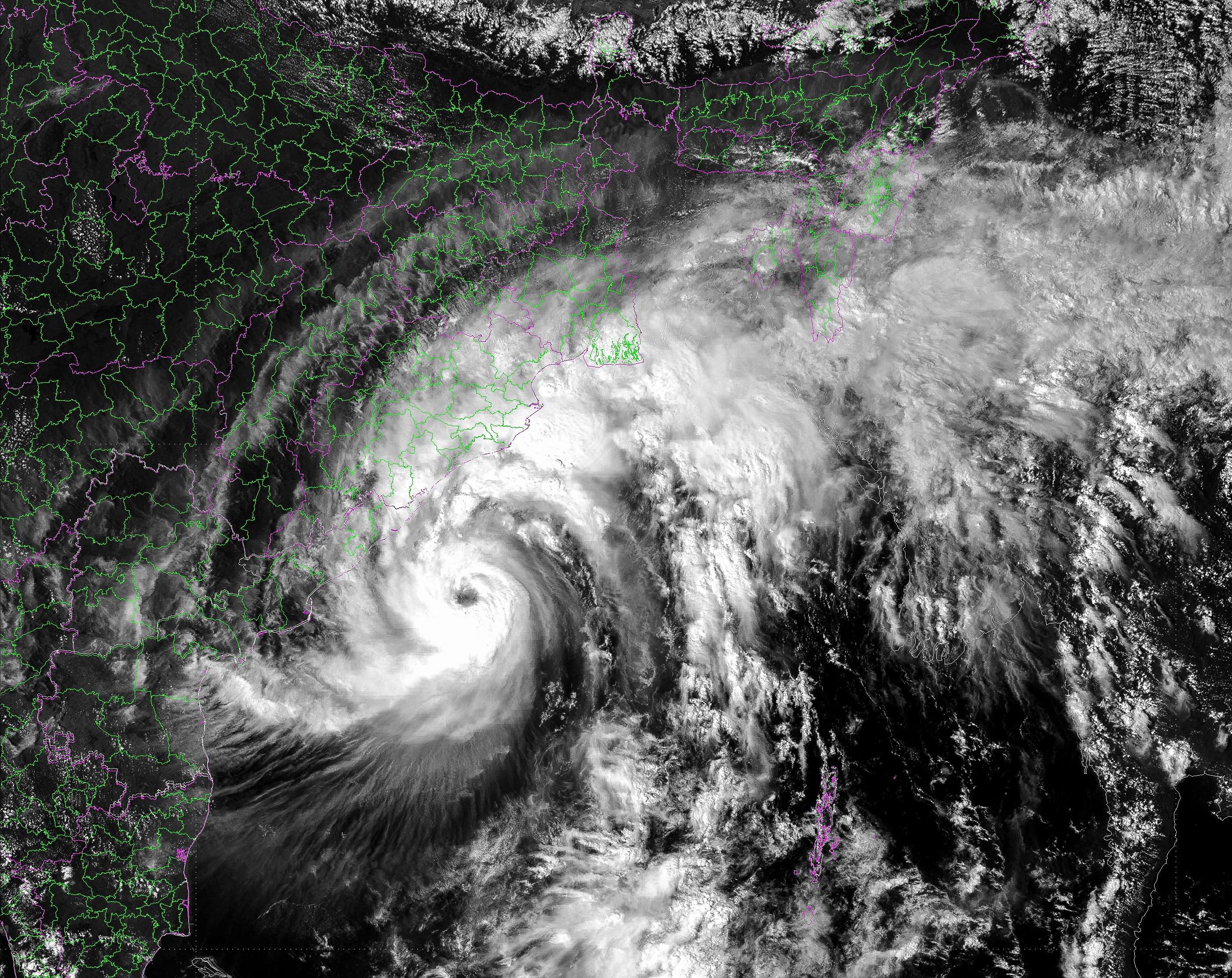
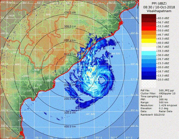
Imran_doomhaMwx wrote:Now within the range of Visakhapatnam radar.
http://www.imd.gov.in/pages/radar_main.php?adta=vsk
https://i.imgur.com/JR6H8A7.jpg
Do you have direct link to the archive of radar image,
I wanna loop it hehe
0 likes
The posts in this forum are NOT official forecast and should not be used as such. They are just the opinion of the poster and may or may not be backed by sound meteorological data. They are NOT endorsed by any professional institution or storm2k.org. For official information, please refer to RSMC, NHC and NWS products.
- mrbagyo
- Category 5
- Posts: 3649
- Age: 32
- Joined: Thu Apr 12, 2012 9:18 am
- Location: 14.13N 120.98E
- Contact:
Re: BOB: TITLI - Very Severe Cyclonic Storm
Got it but with limited frames only.
0 likes
The posts in this forum are NOT official forecast and should not be used as such. They are just the opinion of the poster and may or may not be backed by sound meteorological data. They are NOT endorsed by any professional institution or storm2k.org. For official information, please refer to RSMC, NHC and NWS products.
- mrbagyo
- Category 5
- Posts: 3649
- Age: 32
- Joined: Thu Apr 12, 2012 9:18 am
- Location: 14.13N 120.98E
- Contact:
Re: BOB: TITLI - Very Severe Cyclonic Storm
06B TITLI 181010 1200 17.6N 85.4E IO 90 956
0 likes
The posts in this forum are NOT official forecast and should not be used as such. They are just the opinion of the poster and may or may not be backed by sound meteorological data. They are NOT endorsed by any professional institution or storm2k.org. For official information, please refer to RSMC, NHC and NWS products.
- Cunxi Huang
- Category 1
- Posts: 328
- Age: 26
- Joined: Thu Sep 26, 2013 12:17 pm
- Location: San Jose, CA
- Contact:
Re: BOB: TITLI - Very Severe Cyclonic Storm
I guess we all have missed something.
3 likes
2006 SuTY SAOMAI | 2009 TY LINFA | 2010 TY FANAPI | 2010 SuTY MEGI | 2016 SuTY MERANTI | 2019 SuTY LEKIMA
DO NOT use my posts for life and death decisions. For official information, please refer to products from your RSMC and national weather agency.
- doomhaMwx
- Category 5
- Posts: 2426
- Age: 25
- Joined: Tue Apr 18, 2017 4:01 am
- Location: Baguio/Benguet, Philippines
- Contact:
Re: BOB: TITLI - Very Severe Cyclonic Storm
Making landfall, or has made landfall, over northern Andhra Pradesh, very close to the border with Odisha.
The microwave and radar presentation dramatically improved as it neared the coast. The JTWC intensity estimate @ 18Z is 95kts, but this was likely stronger at landfall.
0 likes
- doomhaMwx
- Category 5
- Posts: 2426
- Age: 25
- Joined: Tue Apr 18, 2017 4:01 am
- Location: Baguio/Benguet, Philippines
- Contact:
Re: BOB: TITLI - Very Severe Cyclonic Storm
Of note, the NOAA SAB / KNES analyzed T6.0 @ 20:30Z, corresponding to a category 4 cyclone!
https://www.ssd.noaa.gov/PS/TROP/storms/TITLI.html
TXIO22 KNES 102120
TCSNIO
A. 06B (TITLI)
B. 10/2030Z
C. 18.7N
D. 84.9E
E. ONE/MET-8
F. T6.0/6.0/D1.5/6HRS
G. IR/EIR/SWIR
H. REMARKS...SYSTEM CHARACTERIZED BY A LG EYE SURROUNDED BY CMG
AND EMBEDDED IN W FOR A DT=6.0. MET AND PT AGREE. FT IS BASED ON
RAPID INTENSIFICATION AS THE 6HR AVERAGE WAS 5.75. GIVEN THE RECENT
INTENSIFICATION TREND A DT=6.0 WAS ESTABLISHED.
I. ADDL POSITIONS
NIL
...FISHER
0 likes
Who is online
Users browsing this forum: No registered users and 4 guests