
Texas Fall 2018
Moderator: S2k Moderators
Forum rules

The posts in this forum are NOT official forecast and should not be used as such. They are just the opinion of the poster and may or may not be backed by sound meteorological data. They are NOT endorsed by any professional institution or STORM2K.
-
weatherdude1108
- Category 5

- Posts: 4172
- Joined: Tue Dec 13, 2011 1:04 pm
- Location: Northwest Austin/Cedar Park, TX
Re: Texas Fall 2018
0 likes
The preceding post is NOT an official forecast, and should not be used as such. It is only the opinion of the poster and may or may not be backed by sound meteorological data. It is NOT endorsed by any professional institution including storm2k.org. For Official Information please refer to the NHC and NWS products.
-
srainhoutx

- S2K Supporter

- Posts: 6919
- Age: 66
- Joined: Sun Jan 14, 2007 11:34 am
- Location: Haywood County, NC
- Contact:
Re: Texas Fall 2018
LCRA to open 4 additional flood gates on Lake Buchanan today for a total of 8 flood gates open. Inflow into Lake Travis expect to cause elevation levels to rise to 700 ft. Serious flood conditions expected to continue as additional rainfall is expected Thursday into Friday.
1 likes
Carla/Alicia/Jerry(In The Eye)/Michelle/Charley/Ivan/Dennis/Katrina/Rita/Wilma/Ike/Harvey
Member: National Weather Association
Wx Infinity Forums
http://wxinfinity.com/index.php
Facebook.com/WeatherInfinity
Twitter @WeatherInfinity
Member: National Weather Association
Wx Infinity Forums
http://wxinfinity.com/index.php
Facebook.com/WeatherInfinity
Twitter @WeatherInfinity
-
Haris

- Category 5
- Posts: 1808
- Joined: Mon Nov 27, 2017 8:19 pm
- Location: ( Bee Cave) West Austin, Texas
Re: Texas Fall 2018
Wow! Lake Travis is just going higher!
With more floodgates open in at Buchanan, forecasts call for 700ft it easily higher.
Haven’t seen this ever!
More rain Thursday won’t help
With more floodgates open in at Buchanan, forecasts call for 700ft it easily higher.
Haven’t seen this ever!
More rain Thursday won’t help
0 likes
Weather geek and a storm spotter in West Austin. Not a degreed meteorologist. Big snow fan. Love rain and cold! Despise heat!
Re: Texas Fall 2018
Latest from LCRA:
Lake Travis is expected to rise to 705 to 710 feet msl by Friday, Oct. 19.
0 likes
-
bubba hotep

- S2K Supporter
- Posts: 5603
- Joined: Wed Dec 28, 2016 1:00 am
- Location: Collin County Texas
Re: Texas Fall 2018
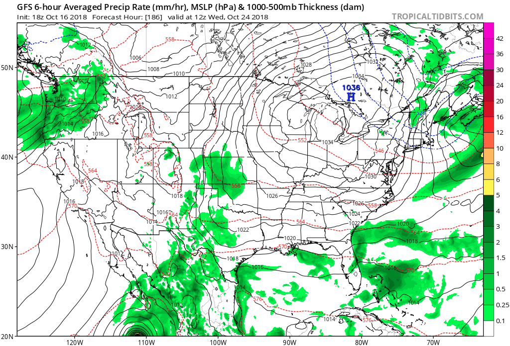
12z GFS has another 4-6" for DFW over the next week 
1 likes
Winter time post are almost exclusively focused on the DFW area.
-
weatherdude1108
- Category 5
- Posts: 4172
- Joined: Tue Dec 13, 2011 1:04 pm
- Location: Northwest Austin/Cedar Park, TX
Re: Texas Fall 2018
utpmg wrote:Latest from LCRA:Lake Travis is expected to rise to 705 to 710 feet msl by Friday, Oct. 19.
710.4 is the record.

0 likes
The preceding post is NOT an official forecast, and should not be used as such. It is only the opinion of the poster and may or may not be backed by sound meteorological data. It is NOT endorsed by any professional institution including storm2k.org. For Official Information please refer to the NHC and NWS products.
-
gboudx

- S2K Supporter
- Posts: 4047
- Joined: Thu Sep 04, 2003 1:39 pm
- Location: Rockwall, Tx but from Harvey, La
Re: Texas Fall 2018
bubba hotep wrote:12z GFS has another 4-6" for DFW over the next week
Ok. Gonna start building an Ark this weekend.
1 likes

Re: Texas Fall 2018
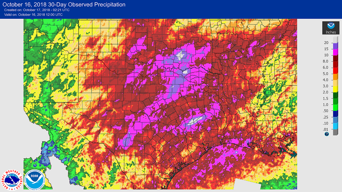
It sucks seeing this for me. I’m basically in a donut hole with red all around me, but this looks to be pretty accurate. I’m in the 2-3” zone on this map while almost everyone else has had double that amount or more with the exception of south and west Texas and the panhandle.
0 likes

Re: Texas Fall 2018
12z GFS has another significant cold front on Halloween. Snow in east Texas down to Mexico, DFW in the 30s. 
2 likes
Undergraduate Meteorology Student at the University of Oklahoma and Operator at the Oklahoma Mesonet.
All opinions independent of employers and the university.
All opinions independent of employers and the university.
-
South Texas Storms

- Professional-Met

- Posts: 4028
- Joined: Thu Jun 24, 2010 12:28 am
- Location: Houston, TX
Re: Texas Fall 2018
SAT currently sits at 4th wettest fall (Sep-Nov), and we are only halfway through! Currently up to 20.39 inches, with 1998 holding the record at 23.04 inches.
2 likes
Re: Texas Fall 2018
Ntxw wrote:The problems won't end here. In about a week to week and half Hurricane Vicente is going to bring yet another flooding event, IMO. Should rapidly or explosively intensify near the Mexican Riveria in the next couple of days. I have to agree with the CPC charts.
https://images2.imgbox.com/9f/d2/o27Ao1IG_o.gif
The CPC has ridiculously high probabilities of rain for Texas. I’m not sure if I’ve ever seen such high probabilities so widespread throughout the entire state. They didn’t even have it that high for Harvey. It even has me here in SETX in the bullseye. The thing is though is that why do they have such high probabilities for Texas during this timeframe when none of the models are backing this up? Sure the models have most of Texas getting at least a few inches of rain, but you’d think with those types of probabilities that the models would be painting widespread totals of 5-10”+ for most of the state. Also, the CPC has SETX in the bullseye when the models have the bullseye for rain over central and north TX. I just can’t make any sense of that CPC forecast. I saw the 10 day forecast for Houston last night on the news and they also didn’t really have anything too crazy regarding rain chances on there either. They had a 60% chance for rain Friday and Saturday and one day next week had 60%, but that’s it. The rest of the days were like 20-30%. They weren’t even mentioning anything about any significant rain events headed our way. Also, the WPC forecast only had around 1” of rain for the next week for SETX.
0 likes

Re: Texas Fall 2018
Cpv17 wrote:Ntxw wrote:The problems won't end here. In about a week to week and half Hurricane Vicente is going to bring yet another flooding event, IMO. Should rapidly or explosively intensify near the Mexican Riveria in the next couple of days. I have to agree with the CPC charts.
https://images2.imgbox.com/9f/d2/o27Ao1IG_o.gif
The CPC has ridiculously high probabilities of rain for Texas. I’m not sure if I’ve ever seen such high probabilities so widespread throughout the entire state. They didn’t even have it that high for Harvey. It even has me here in SETX in the bullseye. The thing is though is that why do they have such high probabilities for Texas during this timeframe when none of the models are backing this up? Sure the models have most of Texas getting at least a few inches of rain, but you’d think with those types of probabilities that the models would be painting widespread totals of 5-10”+ for most of the state. Also, the CPC has SETX in the bullseye when the models have the bullseye for rain over central and north TX. I just can’t make any sense of that CPC forecast. I saw the 10 day forecast for Houston last night on the news and they also didn’t really have anything too crazy regarding rain chances on there either. They had a 60% chance for rain Friday and Saturday and one day next week had 60%, but that’s it. The rest of the days were like 20-30%. They weren’t even mentioning anything about any significant rain events headed our way. Also, the WPC forecast only had around 1” of rain for the next week for SETX.
The overall 500mb historical analogs suggest the pattern that has been in place continues to feature rainfall across the state so I do think the CPC probabilities are good. It is a percentile forecast not qpf forecast that the WPC has. In general the El Nino pattern of wet southern US will continue. The rain forecast will fluctuate with the Hurricane, as you know, is hard to pin down where.
2 likes
The above post and any post by Ntxw is NOT an official forecast and should not be used as such. It is just the opinion of the poster and may or may not be backed by sound meteorological data. It is NOT endorsed by any professional institution including Storm2k. For official information, please refer to NWS products.
Help support Storm2K!
-
Ralph's Weather
- S2K Supporter
- Posts: 2969
- Age: 36
- Joined: Fri Dec 13, 2013 11:55 am
- Location: Lindale, TX
Re: Texas Fall 2018
I think the models may be underestimating the moisture that Vicente will throw into Texas.Cpv17 wrote:Ntxw wrote:The problems won't end here. In about a week to week and half Hurricane Vicente is going to bring yet another flooding event, IMO. Should rapidly or explosively intensify near the Mexican Riveria in the next couple of days. I have to agree with the CPC charts.
https://images2.imgbox.com/9f/d2/o27Ao1IG_o.gif
The CPC has ridiculously high probabilities of rain for Texas. I’m not sure if I’ve ever seen such high probabilities so widespread throughout the entire state. They didn’t even have it that high for Harvey. It even has me here in SETX in the bullseye. The thing is though is that why do they have such high probabilities for Texas during this timeframe when none of the models are backing this up? Sure the models have most of Texas getting at least a few inches of rain, but you’d think with those types of probabilities that the models would be painting widespread totals of 5-10”+ for most of the state. Also, the CPC has SETX in the bullseye when the models have the bullseye for rain over central and north TX. I just can’t make any sense of that CPC forecast. I saw the 10 day forecast for Houston last night on the news and they also didn’t really have anything too crazy regarding rain chances on there either. They had a 60% chance for rain Friday and Saturday and one day next week had 60%, but that’s it. The rest of the days were like 20-30%. They weren’t even mentioning anything about any significant rain events headed our way. Also, the WPC forecast only had around 1” of rain for the next week for SETX.
2 likes
Follow on Facebook at Ralph's Weather.
-
Haris
- Category 5
- Posts: 1808
- Joined: Mon Nov 27, 2017 8:19 pm
- Location: ( Bee Cave) West Austin, Texas
Re: Texas Fall 2018

This is NOT a good !!!!
0 likes
Weather geek and a storm spotter in West Austin. Not a degreed meteorologist. Big snow fan. Love rain and cold! Despise heat!
Re: Texas Fall 2018
Haris wrote:[url]https://preview.ibb.co/cCmCvf/28-A99335-2-D62-4-B40-B40-E-AB1-C2-AAF4-D3-F.png [/url]
This is NOT a good !!!!
He's the only person I've seen say this. Not saying it's not accurate, but LCRA had a press conf at 1:00 but hasn't updated any of their online or twitter feed. Very frustrating. I don't know what they said.Last I saw on their website was re: Buchanan opening four additional gates.
0 likes
-
Ralph's Weather
- S2K Supporter
- Posts: 2969
- Age: 36
- Joined: Fri Dec 13, 2013 11:55 am
- Location: Lindale, TX
Re: Texas Fall 2018
Ensembles and op runs showing -EPO, -AO and -NAO by the end of Oct. The cold, wet pattern continues. At this rate we could be talking wintery precip by the Halloween timeframe which is not unheard of but very rare.
3 likes
Follow on Facebook at Ralph's Weather.
Re: Texas Fall 2018
Skimmed the replay of the PC: indeed, Buchanan with 8 open may open more. Mansfield 4 open maybe 4 more in next 24hr
Look out below.
Look out below.
0 likes
-
gboudx
- S2K Supporter
- Posts: 4047
- Joined: Thu Sep 04, 2003 1:39 pm
- Location: Rockwall, Tx but from Harvey, La
Re: Texas Fall 2018
Cerlin wrote:12z GFS has another significant cold front on Halloween. Snow in east Texas down to Mexico, DFW in the 30s.
This would make for an interesting CaptinCrunch Halloween forecast of winter.
4 likes
Re: Texas Fall 2018
Ralph's Weather wrote:Ensembles and op runs showing -EPO, -AO and -NAO by the end of Oct. The cold, wet pattern continues. At this rate we could be talking wintery precip by the Halloween timeframe which is not unheard of but very rare.
Latest GFS had wintry precip as far south as the mountains in Mexico. Wild
3 likes
Re: Texas Fall 2018
From the LCRA 1 PM press conference: Last week, Lake Travis got more water than the city of Austin uses in four years.
1 likes
Return to “USA & Caribbean Weather”
Who is online
Users browsing this forum: No registered users and 22 guests