WPAC: YUTU - Post-Tropical
Moderator: S2k Moderators
- mrbagyo
- Category 5
- Posts: 3615
- Age: 32
- Joined: Thu Apr 12, 2012 9:18 am
- Location: 14.13N 120.98E
- Contact:
Re: WPAC: YUTU - Typhoon
Latest MW pass.
It's now traversing the high OHC area - could get pretty convective during Dmax later on
0 likes
The posts in this forum are NOT official forecast and should not be used as such. They are just the opinion of the poster and may or may not be backed by sound meteorological data. They are NOT endorsed by any professional institution or storm2k.org. For official information, please refer to RSMC, NHC and NWS products.
-
- Category 5
- Posts: 3408
- Joined: Sat Oct 24, 2009 11:50 pm
Re: WPAC: YUTU - Typhoon
I think it might not even need Dmax to recover as cold convective cloud tops have already started to pop around the new smaller eye, which could mean that the high OHC near Luzon is helping offset the cool and dry northeasterly wind flow.
0 likes
Personal Forecast Disclaimer:
The posts in this forum are NOT official forecast and should not be used as such. They are just the opinion of the poster and may or may not be backed by sound meteorological data. They are NOT endorsed by any professional institution or storm2k.org. For official information, please refer to the NHC and NWS products.
Re: WPAC: YUTU - Typhoon
Making a run to Cat 4 or 5?
0 likes
Remember, all of my post aren't official. For official warnings and discussions, Please refer to your local NWS products...
NWS for the Western Pacific
https://www.weather.gov/gum/
NWS for the Western Pacific
https://www.weather.gov/gum/
-
- Category 5
- Posts: 3408
- Joined: Sat Oct 24, 2009 11:50 pm
Re: WPAC: YUTU - Typhoon
A Cat 4 (more so a Cat5) might be too much, I'm thinking somewhere near 100kts. There's just enough fuel to help this storm to consolidate before landfall, barring another round of dry air ingestion.
0 likes
Personal Forecast Disclaimer:
The posts in this forum are NOT official forecast and should not be used as such. They are just the opinion of the poster and may or may not be backed by sound meteorological data. They are NOT endorsed by any professional institution or storm2k.org. For official information, please refer to the NHC and NWS products.
Re: WPAC: YUTU - Typhoon
UW - CIMSS
ADVANCED DVORAK TECHNIQUE
ADT-Version 9.0
Tropical Cyclone Intensity Algorithm
----- Current Analysis -----
Date : 29 OCT 2018 Time : 061000 UTC
Lat : 16:51:00 N Lon : 125:14:23 E
CI# /Pressure/ Vmax
5.3 / 957.9mb/ 97.2kt
Final T# Adj T# Raw T#
5.3 5.7 5.7
Estimated radius of max. wind based on IR : 16 km
Center Temp : -0.7C Cloud Region Temp : -65.4C
Scene Type : EYE
Subtropical Adjustment : OFF
Extratropical Adjustment : OFF
Positioning Method : ARCHER POSITIONING
Ocean Basin : WEST PACIFIC
Dvorak CI > MSLP Conversion Used : CKZ Method
Tno/CI Rules : Constraint Limits : NO LIMIT
Weakening Flag : OFF
Rapid Dissipation Flag : OFF
C/K/Z MSLP Estimate Inputs :
- Average 34 knot radii : 115nmi
- Environmental MSLP : 1006mb
Satellite Name : HIM-8
Satellite Viewing Angle : 26.5 degrees
****************************************************
0 likes
Remember, all of my post aren't official. For official warnings and discussions, Please refer to your local NWS products...
NWS for the Western Pacific
https://www.weather.gov/gum/
NWS for the Western Pacific
https://www.weather.gov/gum/
- mrbagyo
- Category 5
- Posts: 3615
- Age: 32
- Joined: Thu Apr 12, 2012 9:18 am
- Location: 14.13N 120.98E
- Contact:
Re: WPAC: YUTU - Typhoon
dexterlabio wrote:
A Cat 4 (more so a Cat5) might be too much, I'm thinking somewhere near 100kts. There's just enough fuel to help this storm to consolidate before landfall, barring another round of dry air ingestion.
I think mid 4 is still very attainable. It's really feeling that extra juice
0 likes
The posts in this forum are NOT official forecast and should not be used as such. They are just the opinion of the poster and may or may not be backed by sound meteorological data. They are NOT endorsed by any professional institution or storm2k.org. For official information, please refer to RSMC, NHC and NWS products.
- mrbagyo
- Category 5
- Posts: 3615
- Age: 32
- Joined: Thu Apr 12, 2012 9:18 am
- Location: 14.13N 120.98E
- Contact:
Really: WPAC: YUTU - Typhoon
0 likes
The posts in this forum are NOT official forecast and should not be used as such. They are just the opinion of the poster and may or may not be backed by sound meteorological data. They are NOT endorsed by any professional institution or storm2k.org. For official information, please refer to RSMC, NHC and NWS products.
Re: WPAC: YUTU - Typhoon
Looking more and more impressive.
0 likes
Remember, all of my post aren't official. For official warnings and discussions, Please refer to your local NWS products...
NWS for the Western Pacific
https://www.weather.gov/gum/
NWS for the Western Pacific
https://www.weather.gov/gum/
-
- Category 5
- Posts: 1366
- Age: 24
- Joined: Sun Sep 27, 2015 1:15 am
- Location: Hong Kong
- Contact:
Re: WPAC: YUTU - Typhoon
Latest microwave pass reveals that Yutu still exhibits concentric eyewalls. Low-end category 3 landfall seems reasonable to me at the moment.
0 likes
Personal Forecast Disclaimer:
The posts in this forum are NOT official forecast and should not be used as such. They are just the opinion of the poster and may or may not be backed by sound meteorological data. They are NOT endorsed by any professional institution or storm2k.org. For official information, please refer to RSMC and NWS products.
- mrbagyo
- Category 5
- Posts: 3615
- Age: 32
- Joined: Thu Apr 12, 2012 9:18 am
- Location: 14.13N 120.98E
- Contact:
Re: WPAC: YUTU - Typhoon
0 likes
The posts in this forum are NOT official forecast and should not be used as such. They are just the opinion of the poster and may or may not be backed by sound meteorological data. They are NOT endorsed by any professional institution or storm2k.org. For official information, please refer to RSMC, NHC and NWS products.
Re: WPAC: YUTU - Typhoon
I'm currently in Baguio City right now. Tomorrow October 30, 2018, I'll be going back to Manila. Would you think Baguio City will have stormy bad weather on the October 30, 2018 morning? Thank you for any answer.
0 likes
Re: WPAC: YUTU - Typhoon
WDPN31 PGTW 290900
MSGID/GENADMIN/JOINT TYPHOON WRNCEN PEARL HARBOR HI//
SUBJ/PROGNOSTIC REASONING FOR TYPHOON 31W (YUTU) WARNING NR 32//
RMKS/
1. FOR METEOROLOGISTS.
2. 6 HOUR SUMMARY AND ANALYSIS.
TYPHOON (TY) 31W (YUTU), LOCATED APPROXIMATELY 281 NM EAST-
NORTHEAST OF MANILA, PHILIPPINES, HAS TRACKED WESTWARD AT 09 KNOTS
OVER THE PAST SIX HOURS. THE INITIAL POSITION IS PLACED WITH GOOD
CONFIDENCE USING ANIMATED MULTISPECTRAL SATELLITE IMAGERY WHICH
SHOWS A PARTIALLY CLOUD-FILLED 26 NM EYE. ANIMATED ENHANCED INFRARED
SATELLITE IMAGERY SHOWS THAT CLOUD TOP TEMPERATURES IN THE EYEWALL
HAVE COOLED OVER THE PAST SEVERAL HOURS. THE 90 KNOT INTENSITY
ESTIMATE IS CONSISTENT WITH PGTW/RJTD DVORAK CURRENT INTENSITY
ESTIMATES OF T5.0 (90 KNOTS) AND REFLECTS A PAUSE IN THE WEAKENING
TREND. THE SYSTEM IS IN A MARGINALLY FAVORABLE REGION WITH LOW (10-
15 KNOT) VERTICAL WIND SHEAR (VWS) AND WARM (28-29 CELSIUS) SEA
SURFACE TEMPERATURE BEING PARTIALLY OFFSET BY WEAK RADIAL OUTFLOW.
TY 31W IS TRACKING ALONG THE SOUTHERN PERIPHERY OF AN EAST-WEST
ORIENTED SUBTROPICAL RIDGE (STR).
3. FORECAST REASONING.
A. THERE IS NO CHANGE TO THE FORECAST PHILOSOPHY SINCE THE
PREVIOUS PROGNOSTIC REASONING MESSAGE.
B. TY 31W WILL CONTINUE ON A WESTWARD TO WEST-SOUTHWESTWARD TRACK
AND MAKE LANDFALL ON LUZON SHORTLY AFTER TAU 12 WITH AN INTENSITY OF
ABOUT 85 KNOTS. AFTER MAKING LANDFALL, LAND INTERACTION WILL WEAKEN
THE SYSTEM SIGNIFICANTLY BEFORE IT EXITS LUZON INTO THE SOUTH CHINA
SEA (SCS) SHORTLY AFTER TAU 24. ONCE IN THE SCS, AN APPROACHING MID-
LATITUDE TROUGH WILL CREATE A BREAK IN THE STR AND ALLOW THE CYCLONE
TO TURN NORTHWARD AND RE-INTENSIFY TO 80 KNOTS BY TAU 72. MODEL
GUIDANCE IS IN TIGHT AGREEMENT WITH A 65NM SPREAD AT TAU 48 AND A
165NM SPREAD AT TAU 72. THE JTWC TRACK FORECAST IS PLACED CLOSE
TO THE CONSENSUS TRACK WITH LOW UNCERTAINTY IN THIS PORTION OF THE
JTWC FORECAST.
C. AFTER TAU 72, TY 31W WILL CREST THE STR AXIS AND TRACK MORE
EAST-NORTHEASTWARD. HIGH VWS AND COOL CONTINENTAL AIR WILL REDUCE
THE INTENSITY TO 30 KNOTS BY TAU 120. AS IS COMMON WITH A RECURVING
TROPICAL CYCLONE, SPREAD IN THE MODEL GUIDANCE INCREASES
SIGNIFICANTLY AS THE DEGREE AND TIMING OF THE TURNING VARIES AMONG
THE MODELS. IN THE LATEST RUN, JGSM, COAMPS-GFS, AND (TO SOME
DEGREE) HWRF ARE NOT PREDICTING RECURVATURE BEFORE TAU 120 AND
DEPICT A MORE NORTHWESTWARD TRACK TOWARDS CHINA. THE REMAINING
MODELS ALL DEPICT A RECURVING TRACK, SIMILAR TO THE JTWC TRACK
FORECAST. THE SPREAD BETWEEN THE SOUTHERNMOST (COAMPS-GFS) AND
NORTHERNMOST (GALWEM) MODELS IS OVER 800 NM BY TAU 120, REFLECTING
HIGH UNCERTAINTY IN THE EXTENDED JTWC TRACK FORECAST.//
NNNN
0 likes
Remember, all of my post aren't official. For official warnings and discussions, Please refer to your local NWS products...
NWS for the Western Pacific
https://www.weather.gov/gum/
NWS for the Western Pacific
https://www.weather.gov/gum/
Re: WPAC: YUTU - Typhoon
CURRENT ESTIMATE
Date (mmddhhmm): 10290505
SATCON: MSLP = 936 hPa MSW = 117 knots
SATCON Member Consensus: 113.0 knots
Pressure -> Wind Using SATCON MSLP: 113 knots
Distance to Outer Closed Isobar Used is 200 nm
Eye Size Correction Used is -5.6 knots Source: MW
Member Estimates
ADT: 952 hPa 102 knots Scene: CDO Date: OCT290710
CIMSS AMSU: 919 hPa 131 knots Bias Corr: 0 (MW) Date: 10290110
ATMS: 925.4 hPa 127.4 knots Date: 10290505
SSMIS: 925.4 hPa 127.4 knots Date: 10290505
CIRA ATMS: 942 hPa 113 knots Date: 10281707
JTWC on the low side of the estimates with dvorak.
0 likes
Remember, all of my post aren't official. For official warnings and discussions, Please refer to your local NWS products...
NWS for the Western Pacific
https://www.weather.gov/gum/
NWS for the Western Pacific
https://www.weather.gov/gum/
- mrbagyo
- Category 5
- Posts: 3615
- Age: 32
- Joined: Thu Apr 12, 2012 9:18 am
- Location: 14.13N 120.98E
- Contact:
Re: WPAC: YUTU - Typhoon
cebuboy wrote:I'm currently in Baguio City right now. Tomorrow October 30, 2018, I'll be going back to Manila. Would you think Baguio City will have stormy bad weather on the October 30, 2018 morning? Thank you for any answer.
Rain will likely start to fall by morning then it will be stormy by afternoon - closing down of Naguillan Road and Marcos Highway is a possibility (Kennon has been closed for months already).
0 likes
The posts in this forum are NOT official forecast and should not be used as such. They are just the opinion of the poster and may or may not be backed by sound meteorological data. They are NOT endorsed by any professional institution or storm2k.org. For official information, please refer to RSMC, NHC and NWS products.
- mrbagyo
- Category 5
- Posts: 3615
- Age: 32
- Joined: Thu Apr 12, 2012 9:18 am
- Location: 14.13N 120.98E
- Contact:
Re: WPAC: YUTU - Typhoon
https://twitter.com/iCyclone/status/1056890456993226752
Pretty sure this is in Alfonso Castaneda, N. Viscaya - still about 4 hours from Dilasag, Aurora
The center could pass way north of his target but he could still get the core (because of the huge eye) in there or in Dinapigue (if he pushed northward even more).
Only available reporting station along the coast is on Baler and Casiguran.
0 likes
The posts in this forum are NOT official forecast and should not be used as such. They are just the opinion of the poster and may or may not be backed by sound meteorological data. They are NOT endorsed by any professional institution or storm2k.org. For official information, please refer to RSMC, NHC and NWS products.
Re: WPAC: YUTU - Typhoon
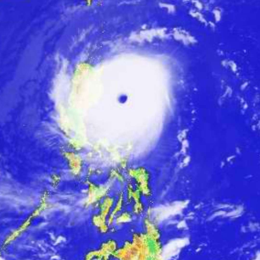
mrbagyo wrote:https://twitter.com/iCyclone/status/1056890456993226752
Pretty sure this is in Alfonso Castaneda, N. Viscaya - still about 4 hours from Dilasag, Aurora
The center could pass way north of his target but he could still get the core (because of the huge eye) in there or in Dinapigue (if he pushed northward even more).
Only available reporting station along the coast is on Baler and Casiguran.
There are also reporting stations in Dinapigue, Dilasag, Dinalungan and many more further south and west:
https://weather.us/observations/1220-e-162-n/wind-average-10min/20181029-1500z.html
0 likes
- cycloneye
- Admin
- Posts: 139308
- Age: 67
- Joined: Thu Oct 10, 2002 10:54 am
- Location: San Juan, Puerto Rico
Re: WPAC: YUTU - Typhoon
He keeps going north to the sweet spot for him.
https://twitter.com/iCyclone/status/1056928538815815681
0 likes
Visit the Caribbean-Central America Weather Thread where you can find at first post web cams,radars
and observations from Caribbean basin members Click Here
- cycloneye
- Admin
- Posts: 139308
- Age: 67
- Joined: Thu Oct 10, 2002 10:54 am
- Location: San Juan, Puerto Rico
Re: WPAC: YUTU - Typhoon
He didn't make it to where he wanted to be.
https://twitter.com/iCyclone/status/1056987908547231744
https://twitter.com/iCyclone/status/1056990650711900160
https://twitter.com/iCyclone/status/1056987908547231744
https://twitter.com/iCyclone/status/1056990650711900160
0 likes
Visit the Caribbean-Central America Weather Thread where you can find at first post web cams,radars
and observations from Caribbean basin members Click Here
Who is online
Users browsing this forum: No registered users and 20 guests