

TXPQ28 KNES 070903
TCSWNP
A. TROPICAL DISTURBANCE (98C)
B. 07/0830Z
C. 6.8N
D. 178.5E
E. THREE/HIMAWARI-8
F. T1.5/1.5/D0.5/24HRS
G. IR/EIR/SWIR
H. REMARKS...THIS INTENSITY ESTIMATE WAS DERIVED USING 4 KM IR
DATA. LOOSELY DEFINED CLOUD LINES NEAR SMALL OVERCAST RESULTS IN
DT=1.5. MET AND PT AGREE. FT IS BASED ON MET DUE TO IMMATURE CONVECTION.
I. ADDL POSITIONS
NIL
...BOLL
WPAC: USAGI - Post-Tropical
Moderator: S2k Moderators
Re: WPAC: INVEST 98C
0 likes
Remember, all of my post aren't official. For official warnings and discussions, Please refer to your local NWS products...
NWS for the Western Pacific
https://www.weather.gov/gum/
NWS for the Western Pacific
https://www.weather.gov/gum/
Re: WPAC: INVEST 98C
CMC, JMA, and NAVGEM continues to bring in a significant TC towards the Marianas.
GFS and EURO barely develops this.
GFS and EURO barely develops this.
0 likes
Remember, all of my post aren't official. For official warnings and discussions, Please refer to your local NWS products...
NWS for the Western Pacific
https://www.weather.gov/gum/
NWS for the Western Pacific
https://www.weather.gov/gum/
Re: WPAC: INVEST 98C
98C INVEST 181107 1800 6.8N 177.9E CPAC 20 1005

0 likes
Remember, all of my post aren't official. For official warnings and discussions, Please refer to your local NWS products...
NWS for the Western Pacific
https://www.weather.gov/gum/
NWS for the Western Pacific
https://www.weather.gov/gum/
Re: WPAC: INVEST 98C
Up to MEDIUM.
THE AREA OF CONVECTION (INVEST 98C) PREVIOUSLY LOCATED
NEAR 6.8N 179.4E, IS NOW LOCATED NEAR 7.0N 177.2E, APPROXIMATELY 565
NM EAST OF KWAJALEIN. ANIMATED ENHANCED INFRARED IMAGERY DEPICTS A
BROAD LOW LEVEL CIRCULATION (LLC) WITH FLARING DISORGANIZED
CONVECTION LOCATED PRIMARILY ALONG A HORIZONTAL SHEAR LINE. A
080130Z AMSR-2 89GHZ IMAGE EMPHASIZES THAT THE LLC IS SLOWLY
CONSOLIDATING, BUT THERE IS MINIMAL DEEP CONVECTION. VERTICAL WIND
SHEAR IS LOW (5-10 KTS) AND THERE IS GOOD POLEWARD OUTFLOW. SEA
SURFACE TEMPERATURES REMAINS WARM AT 28-30 DEGREES CELSIUS. GLOBAL
MODELS ARE SPLIT ON WHETHER THE AREA OF CONVECTION WILL REACH
WARNING CRITERIA. NAVGEM MOST FAVORS DEVELOPMENT OF THE SYSTEM INTO
A STRONG TROPICAL CYCLONE IN LATER TAUS WHILE ECMWF DEVELOPS 98C
INTO A WEAK, BORDERLINE SYSTEM. OTHER GLOBAL MODELS, INCLUDING GFS,
SHOW THE SYSTEM CONTINUING WESTWARD AS A TROUGH. THE GENERAL
MOVEMENT OF THE SYSTEM WILL BE WESTWARD OR NORTHWESTWARD. MAXIMUM
SUSTAINED SURFACE WINDS ARE ESTIMATED AT 15 TO 20 KNOTS. MINIMUM SEA
LEVEL PRESSURE IS ESTIMATED TO BE NEAR 1003 MB. THE POTENTIAL FOR
THE DEVELOPMENT OF A SIGNIFICANT TROPICAL CYCLONE WITHIN THE NEXT 24
HOURS IS UPGRADED TO MEDIUM.
0 likes
Remember, all of my post aren't official. For official warnings and discussions, Please refer to your local NWS products...
NWS for the Western Pacific
https://www.weather.gov/gum/
NWS for the Western Pacific
https://www.weather.gov/gum/
Re: WPAC: INVEST 98C
TXPQ28 KNES 080259
TCSWNP
A. TROPICAL DISTURBANCE (98C)
B. 08/0230Z
C. 6.9N
D. 175.9E
E. FIVE/HIMAWARI-8
F. TOO WEAK
G. IR/EIR/VIS
H. REMARKS...THIS ESTIMATE WAS DERIVED USING 4 KM IR DATA. THIS SYSTEM
IS TOO WEAK TO CLASSIFY BECAUSE BANDING IS LESS THAN 2/10. THIS WILL BE
THE FINAL BULLETIN ISSUED UNLESS REGENERATION OCCURS.
I. ADDL POSITIONS
NIL
...TURK
0 likes
Remember, all of my post aren't official. For official warnings and discussions, Please refer to your local NWS products...
NWS for the Western Pacific
https://www.weather.gov/gum/
NWS for the Western Pacific
https://www.weather.gov/gum/

Re: WPAC: INVEST 98C
NEW TROPICAL STORM FORECAST TO DEVELOP AFTER 48 HOURS
FORECAST POSITION AT T+ 48 : 8.7N 169.0E
VERIFYING TIME POSITION STRENGTH TENDENCY
-------------- -------- -------- --------
12UTC 10.11.2018 8.7N 169.0E WEAK
00UTC 11.11.2018 9.4N 166.8E WEAK LITTLE CHANGE
12UTC 11.11.2018 9.8N 164.5E WEAK LITTLE CHANGE
00UTC 12.11.2018 10.6N 162.7E WEAK LITTLE CHANGE
12UTC 12.11.2018 10.9N 161.4E MODERATE INTENSIFYING SLIGHTLY
00UTC 13.11.2018 11.5N 160.3E MODERATE INTENSIFYING SLIGHTLY
12UTC 13.11.2018 12.2N 159.1E STRONG INTENSIFYING SLIGHTLY
00UTC 14.11.2018 12.8N 158.2E STRONG LITTLE CHANGE
12UTC 14.11.2018 13.4N 157.3E MODERATE LITTLE CHANGE
0 likes
ヤンデレ女が寝取られるているのを見たい!!!
ECMWF ensemble NWPAC plots: https://ecmwfensnwpac.imgbb.com/
Multimodel NWPAC plots: https://multimodelnwpac.imgbb.com/
GFS Ensemble NWPAC plots (16 & 35 day forecast): https://gefsnwpac.imgbb.com/
Plots updated automatically
ECMWF ensemble NWPAC plots: https://ecmwfensnwpac.imgbb.com/
Multimodel NWPAC plots: https://multimodelnwpac.imgbb.com/
GFS Ensemble NWPAC plots (16 & 35 day forecast): https://gefsnwpac.imgbb.com/
Plots updated automatically
Re: WPAC: INVEST 98C
Marianas are in an almost dry season trade-wind pattern for the next
several days. The feature most likely to interrupt that could be the
invest area currently numbered 98C. All models are moving in the
range of west to northwest. The GEFS brings it closest to the
Marianas waters, but also keeps it the weakest. The FENS and the
CMC keep it east of 150 and start moving it northward, while they
strengthen it more. This situation definitely bears watching, for now
though the threat seems rather mild.
Eastern Micronesia and Chuuk...
The eastern portion of a near-equatorial trough passes south of
Chuuk, Pohnpei and Kosrae then turns east-northeastward to link up
with a tropical disturbance, JTWC Invest 98C east of Majuro near
7N178E. Latest ASCAT imagery reveals the trade-wind surge is
weakening north of the trough. This should allow shower activity to
gradually decrease across the region today and this evening. For
Chuuk, Pohnpei and Kosrae, a drier mid-level air mass should further
improve the weather by Saturday. On the other hand, the close
proximity of 98C will maintain the threat of thunderstorms near
Majuro thru Saturday afternoon.
All model guidance is tracking 98C slowly west-northwestward across
Micronesia starting from later this weekend thru most of the next
week. Among them, NavGem is the only model which develops 98C
further into a tropical depression or weak tropical storm between the
Marianas and Chuuk toward next weekend. However, latest IR and VIS
satellite loops show persistent deep convection just east and
northeast of its center. This is likely aided by divergent flow
associated with a nearby TUTT cell. If this trend continues thru this
evening, further development on 98C is possible and will need to be
monitored closely. Nevertheless, as 98C approaches the Marshall
Islands starting Saturday evening, periods of heavy showers and gusty
winds are probable thru Sunday night. Afterward, a trade-wind
convergence zone migrating westward from east of the Date Line will
prolong instability near Majuro thru early next week. Wet weather
associated with 98C will also reach Kosrae and Pohnpei early next
week, Chuuk near midweek.
0 likes
Remember, all of my post aren't official. For official warnings and discussions, Please refer to your local NWS products...
NWS for the Western Pacific
https://www.weather.gov/gum/
NWS for the Western Pacific
https://www.weather.gov/gum/

Re: WPAC: INVEST 98C

WTPN21 PGTW 090130
MSGID/GENADMIN/JOINT TYPHOON WRNCEN PEARL HARBOR HI//
SUBJ/TROPICAL CYCLONE FORMATION ALERT//
RMKS/
1. FORMATION OF A SIGNIFICANT TROPICAL CYCLONE IS POSSIBLE WITHIN
135 NM EITHER SIDE OF A LINE FROM 7.7N 174.9E TO 9.6N 167.5E
WITHIN THE NEXT 12 TO 24 HOURS. AVAILABLE DATA DOES NOT JUSTIFY
ISSUANCE OF NUMBERED TROPICAL CYCLONE WARNINGS AT THIS TIME.
WINDS IN THE AREA ARE ESTIMATED TO BE 25 TO 30 KNOTS. METSAT
IMAGERY AT 082330Z INDICATES THAT A CIRCULATION CENTER IS LOCATED
NEAR 8.0N 174.4E. THE SYSTEM IS MOVING WESTWARD AT 08 KNOTS.
2. REMARKS:
THE AREA OF CONVECTION (INVEST 98C) PREVIOUSLY LOCATED NEAR 7.0N
177.2E, IS NOW LOCATED NEAR 8.0N 174.4E, APPROXIMATELY 393 NM EAST
OF KWAJALEIN. ANIMATED MULTISPECTRAL SATELLITE IMAGERY SHOWS DEEP
CONVECTION LOCATED TO THE WEST OF THE POORLY DEFINED LOW LEVEL
CIRCULATION CENTER (LLCC). THE INITIAL POSITION IS PLACED WITH POOR
CONFIDENCE AND IS BASED ON A 082202Z METOP-A ASCAT IMAGE WHICH SHOWS
THAT THE LLCC IS POORLY ORGANIZED AND CONTINUES TO CONSOLIDATE.
HOWEVER, THERE IS A SWATH OF 25 TO 30 KNOT WINDS LOCATED NORTH OF
THE LLCC. 98C IS EXPERIENCING FAVORABLE VERTICAL WIND SHEAR (10 TO
15 KNOTS) AND HAS A DEVELOPING POLEWARD OUTFLOW CHANNEL. SEA SURFACE
TEMPERATURES ARE FAVORABLE FOR DEVELOPMENT, BETWEEN 28 AND 30
DEGREES CELSIUS. GLOBAL MODELS SHOW 98C TRACKING WEST TO
NORTHWESTWARD AND CONSOLIDATING OVER THE NEXT 24 HOURS WITH THE
STRONGEST WINDS REMAINING NORTH OF THE LLCC. MAXIMUM SUSTAINED
SURFACE WINDS ARE ESTIMATED AT 18 TO 23 KNOTS. MINIMUM SEA LEVEL
PRESSURE IS ESTIMATED TO BE NEAR 1003 MB. THE POTENTIAL FOR THE
DEVELOPMENT OF A SIGNIFICANT TROPICAL CYCLONE WITHIN THE NEXT 24
HOURS IS HIGH.
3. THIS ALERT WILL BE REISSUED, UPGRADED TO WARNING OR CANCELLED BY
100130Z.//
NNNN
0 likes
Remember, all of my post aren't official. For official warnings and discussions, Please refer to your local NWS products...
NWS for the Western Pacific
https://www.weather.gov/gum/
NWS for the Western Pacific
https://www.weather.gov/gum/
Re: WPAC: INVEST 98C
000
WWPQ80 PGUM 090243
SPSPQ
SPECIAL WEATHER STATEMENT
NATIONAL WEATHER SERVICE TIYAN GU
1243 PM ChST Fri Nov 9 2018
PMZ181-100200-
MAJURO-
1243 PM ChST Fri Nov 9 2018
...DEVELOPING CIRCULATION TO THE EAST-NORTHEAST OF MAJURO...
A TROPICAL DISTURBANCE IS CURRENTLY LOCATED NEAR 8.0N AND 174.4E.
THIS IS ABOUT 230 MILES EAST-NORTHEAST OF MAJURO. THE DISTURBANCE IS
NOW THE SUBJECT OF A TROPICAL CYCLONE FORMATION ALERT /TCFA/ ISSUED
BY THE JOINT TYPHOON WARNING CENTER /JTWC/. COMPUTER MODELS INDICATE
A SLOW WEST-NORTHWEST TRACK OVER THE NEXT SEVERAL DAYS WITH THE
SYSTEM PASSING JUST NORTH OF MAJURO SATURDAY.
FOR ATOLLS NEAR AND NORTH OF WOTJE AND KWAJALEIN...STRONGER WINDS
NORTHEAST TO EAST WINDS...WITH GUSTS UP TO 35 MPH...ARE EXPECTED AS
EARLY AS LATE TONIGHT AND WILL CONTINUE THROUGH SATURDAY NIGHT OR
SUNDAY. COMBINED SEAS WILL BUILD UP TO 12 FEET DURING THE NEXT COUPLE
OF DAYS. HEAVY RAIN AND OCCASIONAL LIGHTNING WILL PRODUCE ADDITIONAL
HAZARDS.
FOR ATOLLS SOUTH OF WOTJE AND KWAJALEIN...INCLUDING MAJURO...NORTH TO
NORTHWEST WINDS WILL TURN TO THE WEST AND SOUTHWEST SATURDAY. WINDS
WILL BE SLIGHTLY WEAKER SOUTH OF THE CENTER OF THE DISTURBANCE...BUT
WILL BE GUSTY AT TIMES AS SHOWERS DEVELOP ON SATURDAY AND SUNDAY.
HAZARDOUS SEA AND SURF CONDITIONS COULD PERSIST ACROSS THE REPUBLIC
OF THE MARSHALL ISLANDS THROUGH THE WEEKEND. TRAVEL BY SMALL BOAT IS
NOT ADVISED UNTIL CONDITIONS IMPROVE.
RESIDENTS OF THE MARSHALL ISLANDS SHOULD CONTINUE TO MONITOR THIS
SITUATION AND HEED THE INSTRUCTIONS FROM THEIR LOCAL EMERGENCY
MANAGEMENT AND WEATHER SERVICE OFFICES. FOR MORE INFORMATION ON THE
TCFA...SEE BULLETINS ISSUED BY THE JTWC UNDER WMO HEADER WTPN21 PGTW.
THE LATEST WEATHER FORECASTS AND ADVISORIES ARE AVAILABLE ON THE WFO
GUAM WEBSITE AT WWW.WEATHER.GOV/GUM/
$$
STANKO/GUARD/W. AYDLETT
0 likes
Remember, all of my post aren't official. For official warnings and discussions, Please refer to your local NWS products...
NWS for the Western Pacific
https://www.weather.gov/gum/
NWS for the Western Pacific
https://www.weather.gov/gum/
Re: WPAC: INVEST 98C

0 likes
Remember, all of my post aren't official. For official warnings and discussions, Please refer to your local NWS products...
NWS for the Western Pacific
https://www.weather.gov/gum/
NWS for the Western Pacific
https://www.weather.gov/gum/
Re: WPAC: INVEST 98C
Potent Kelvin Wave moving through that will likely aid in it's development.
0 likes
Remember, all of my post aren't official. For official warnings and discussions, Please refer to your local NWS products...
NWS for the Western Pacific
https://www.weather.gov/gum/
NWS for the Western Pacific
https://www.weather.gov/gum/
Re: WPAC: INVEST 98C
TPPN10 PGTW 090908
A. TROPICAL DISTURBANCE 98C (NE OF MAJURO)
B. 09/0840Z
C. 8.45N
D. 172.75E
E. THREE/HMWRI8
F. N/A
G. IR/EIR
H. REMARKS: 17A/PBO XPSD LLCC/ANMTN. THIS SYSTEM IS TOO WEAK TO
CLASSIFY.
I. ADDITIONAL POSITIONS: NONE
LOWE
A. TROPICAL DISTURBANCE 98C (NE OF MAJURO)
B. 09/0840Z
C. 8.45N
D. 172.75E
E. THREE/HMWRI8
F. N/A
G. IR/EIR
H. REMARKS: 17A/PBO XPSD LLCC/ANMTN. THIS SYSTEM IS TOO WEAK TO
CLASSIFY.
I. ADDITIONAL POSITIONS: NONE
LOWE
0 likes
Remember, all of my post aren't official. For official warnings and discussions, Please refer to your local NWS products...
NWS for the Western Pacific
https://www.weather.gov/gum/
NWS for the Western Pacific
https://www.weather.gov/gum/
Re: WPAC: INVEST 98C
The circulation ENE of Majuro, JTWC Invest 98C, now the subject of a
TCFA, is centered near 8N174E. Daytime scatterometry data showed the
strongest winds north of the center. The system is encountering
upper-level shear that is keeping deep convection north and east of
the center. A couple of circulation centers have been observed during
the afternoon in addition to the center depicted in ASCAT data. GFS
and ECMWF have been persistent in keeping 98C farther south than
currently in satellite imagery and also weaker in the long range.
NavGem takes the lead in showing gradual development as it moves WNW
the next several days. The current weak state of 98C, the sheared
environment, and the disagreement in model guidance results in low
confidence and high uncertainty in exactly what to expect the next
several days. 98C will certainly need to be closely monitored by all
of Micronesia and the Marianas. Models will gradually get a better
handle on things in the next day or two.
Invest 98C remains ENE of Majuro and a trough extends westward south
of Kosrae, Pohnpei and Chuuk. Currently, the NavGem initializes best
so the current forecast of winds and convection more closely follows
that model and assumes a passage of 98C to the north of Majuro late
tonight and early Saturday. For Majuro, wetter weather is expected
late in the weekend once 98C has passed to the NW and south to
southeast winds have overtaken the area. Kosrae, Pohnpei and Chuuk
are still expected to see a small increase in clouds and isolated
thunderstorms early next week as 98C passes near and north of all 3
locations. Models keep the bulk of precipitation closer or north of
98C, so showers are not expected to be as wide spread for now. In the
next day or two, model consensus should greatly improve on how to
handle 98C and then the rain outlooks can be fine tuned.
0 likes
Remember, all of my post aren't official. For official warnings and discussions, Please refer to your local NWS products...
NWS for the Western Pacific
https://www.weather.gov/gum/
NWS for the Western Pacific
https://www.weather.gov/gum/
Re: WPAC: INVEST 98C
Models including EURO, GFS, and now NAVGEM shows little to no development.
0 likes
Remember, all of my post aren't official. For official warnings and discussions, Please refer to your local NWS products...
NWS for the Western Pacific
https://www.weather.gov/gum/
NWS for the Western Pacific
https://www.weather.gov/gum/
Re: WPAC: INVEST 98C
ukmet is going back and forth with development
GLOBAL MODEL DATA TIME 00UTC 09.11.2018
TROPICAL DEPRESSION 98C ANALYSED POSITION : 8.0N 174.0E
VERIFYING TIME POSITION STRENGTH TENDENCY
-------------- -------- -------- --------
00UTC 09.11.2018 8.0N 174.0E WEAK
12UTC 09.11.2018 BELOW TROPICAL STORM STRENGTH
GLOBAL MODEL DATA TIME 00UTC 09.11.2018
TROPICAL DEPRESSION 98C ANALYSED POSITION : 8.0N 174.0E
VERIFYING TIME POSITION STRENGTH TENDENCY
-------------- -------- -------- --------
00UTC 09.11.2018 8.0N 174.0E WEAK
12UTC 09.11.2018 BELOW TROPICAL STORM STRENGTH
0 likes
ヤンデレ女が寝取られるているのを見たい!!!
ECMWF ensemble NWPAC plots: https://ecmwfensnwpac.imgbb.com/
Multimodel NWPAC plots: https://multimodelnwpac.imgbb.com/
GFS Ensemble NWPAC plots (16 & 35 day forecast): https://gefsnwpac.imgbb.com/
Plots updated automatically
ECMWF ensemble NWPAC plots: https://ecmwfensnwpac.imgbb.com/
Multimodel NWPAC plots: https://multimodelnwpac.imgbb.com/
GFS Ensemble NWPAC plots (16 & 35 day forecast): https://gefsnwpac.imgbb.com/
Plots updated automatically
Re: WPAC: INVEST 98C
FXXT03 EGRR 091556
MET OFFICE TROPICAL CYCLONE GUIDANCE FOR NORTH-WEST PACIFIC
GLOBAL MODEL DATA TIME 12UTC 09.11.2018
TROPICAL DEPRESSION 98C ANALYSED POSITION : 8.3N 172.1E
VERIFYING TIME POSITION STRENGTH TENDENCY
-------------- -------- -------- --------
12UTC 09.11.2018 8.3N 172.1E WEAK
00UTC 10.11.2018 8.6N 169.9E WEAK LITTLE CHANGE
12UTC 10.11.2018 8.5N 168.6E WEAK LITTLE CHANGE
00UTC 11.11.2018 9.3N 167.1E WEAK LITTLE CHANGE
12UTC 11.11.2018 BELOW TROPICAL STORM STRENGTH
NEW TROPICAL STORM FORECAST TO DEVELOP AFTER 84 HOURS
FORECAST POSITION AT T+ 84 : 12.7N 158.9E
VERIFYING TIME POSITION STRENGTH TENDENCY
-------------- -------- -------- --------
00UTC 13.11.2018 12.7N 158.9E WEAK
12UTC 13.11.2018 13.1N 156.6E WEAK LITTLE CHANGE
00UTC 14.11.2018 12.6N 154.4E WEAK LITTLE CHANGE
12UTC 14.11.2018 12.6N 152.3E WEAK LITTLE CHANGE
00UTC 15.11.2018 12.4N 151.3E WEAK LITTLE CHANGE
12UTC 15.11.2018 12.3N 150.3E WEAK LITTLE CHANGE
0 likes
ヤンデレ女が寝取られるているのを見たい!!!
ECMWF ensemble NWPAC plots: https://ecmwfensnwpac.imgbb.com/
Multimodel NWPAC plots: https://multimodelnwpac.imgbb.com/
GFS Ensemble NWPAC plots (16 & 35 day forecast): https://gefsnwpac.imgbb.com/
Plots updated automatically
ECMWF ensemble NWPAC plots: https://ecmwfensnwpac.imgbb.com/
Multimodel NWPAC plots: https://multimodelnwpac.imgbb.com/
GFS Ensemble NWPAC plots (16 & 35 day forecast): https://gefsnwpac.imgbb.com/
Plots updated automatically
Re: WPAC: INVEST 98C

0 likes
Remember, all of my post aren't official. For official warnings and discussions, Please refer to your local NWS products...
NWS for the Western Pacific
https://www.weather.gov/gum/
NWS for the Western Pacific
https://www.weather.gov/gum/
Re: WPAC: INVEST 98C
98C INVEST
As of 18:00 UTC Nov 09, 2018:
Location: 8.6°N 170.8°E
Maximum Winds: 20 kt
Minimum Central Pressure: 1002 mb
As of 18:00 UTC Nov 09, 2018:
Location: 8.6°N 170.8°E
Maximum Winds: 20 kt
Minimum Central Pressure: 1002 mb
0 likes
Remember, all of my post aren't official. For official warnings and discussions, Please refer to your local NWS products...
NWS for the Western Pacific
https://www.weather.gov/gum/
NWS for the Western Pacific
https://www.weather.gov/gum/
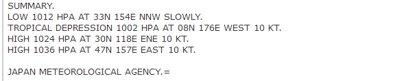
Re: WPAC: INVEST 98C
Poof on JMA's weather maps
0 likes
ヤンデレ女が寝取られるているのを見たい!!!
ECMWF ensemble NWPAC plots: https://ecmwfensnwpac.imgbb.com/
Multimodel NWPAC plots: https://multimodelnwpac.imgbb.com/
GFS Ensemble NWPAC plots (16 & 35 day forecast): https://gefsnwpac.imgbb.com/
Plots updated automatically
ECMWF ensemble NWPAC plots: https://ecmwfensnwpac.imgbb.com/
Multimodel NWPAC plots: https://multimodelnwpac.imgbb.com/
GFS Ensemble NWPAC plots (16 & 35 day forecast): https://gefsnwpac.imgbb.com/
Plots updated automatically
Who is online
Users browsing this forum: No registered users and 11 guests