
Deep South/Southeastern US Winter 2018-19 (GA, SC, NC, TN, FL, AL, MS, LA)
Moderator: S2k Moderators
Forum rules
 The posts in this forum are NOT official forecast and should not be used as such. They are just the opinion of the poster and may or may not be backed by sound meteorological data. They are NOT endorsed by any professional institution or STORM2K.

The posts in this forum are NOT official forecast and should not be used as such. They are just the opinion of the poster and may or may not be backed by sound meteorological data. They are NOT endorsed by any professional institution or STORM2K.
-
northjaxpro

- S2K Supporter

- Posts: 8900
- Joined: Mon Sep 27, 2010 11:21 am
- Location: Jacksonville, FL
Re: Deep South/Southeastern US Winter 2018-19 (GA, SC, NC, TN, FL, AL, MS, LA)
Meanwhile, interesting change with the 12Z NAM, which is quite different this run than the 12Z GFS. It shifts the heaviest snowfall accumulations a little farther north into Southern Virginia, with generally 3-5 inch snowfall totals shown across the North Carolina Piedmont and Foothills. Also, NAM is showing light snow accumulations potential well down into the SC Midlands, and as far south to Charleston, SC this run as a result of the potent Upper Level Low moving across the region on late Monday through Tuesday afternoon.
0 likes
NEVER, EVER SAY NEVER in the tropics and weather in general, and most importantly, with life itself!!
________________________________________________________________________________________
Fay 2008 Beryl 2012 Debby 2012 Colin 2016 Hermine 2016 Julia 2016 Matthew 2016 Irma 2017 Dorian 2019
________________________________________________________________________________________
Fay 2008 Beryl 2012 Debby 2012 Colin 2016 Hermine 2016 Julia 2016 Matthew 2016 Irma 2017 Dorian 2019


Re: Deep South/Southeastern US Winter 2018-19 (GA, SC, NC, TN, FL, AL, MS, LA)
Here it comes! I await to see what it brings to the Chapel Hill-Durham area, hard to believe we're about to get another early Dec snow event here, and one that might rival the January snowstorm from earlier this year! 
Going to be a very interesting few days here!
Going to be a very interesting few days here!
1 likes
Georges '98, Irene '99, Frances '04, Jeanne '04, Katrina '05, Wilma '05, Gustav '08, Isaac '12, Matthew '16, Florence '18, Michael '18, Ian '22
-
northjaxpro
- S2K Supporter
- Posts: 8900
- Joined: Mon Sep 27, 2010 11:21 am
- Location: Jacksonville, FL
Re: Deep South/Southeastern US Winter 2018-19 (GA, SC, NC, TN, FL, AL, MS, LA)
Also, I definitely do not want to forget about Southern Virginia, as GFS and NAM model runs continue to indicate potential heavy snowfall totals upwards to near a foot across potions of that area as well. The models have slightly shifted north in the past 12 hours with regards to the potential of heavy snowfall there.
0 likes
NEVER, EVER SAY NEVER in the tropics and weather in general, and most importantly, with life itself!!
________________________________________________________________________________________
Fay 2008 Beryl 2012 Debby 2012 Colin 2016 Hermine 2016 Julia 2016 Matthew 2016 Irma 2017 Dorian 2019
________________________________________________________________________________________
Fay 2008 Beryl 2012 Debby 2012 Colin 2016 Hermine 2016 Julia 2016 Matthew 2016 Irma 2017 Dorian 2019
-
gatorcane

- S2K Supporter
- Posts: 23499
- Age: 46
- Joined: Sun Mar 13, 2005 3:54 pm
- Location: Boca Raton, FL
Re: Deep South/Southeastern US Winter 2018-19 (GA, SC, NC, TN, FL, AL, MS, LA)
Looks really impressive:
0 likes
-
northjaxpro
- S2K Supporter
- Posts: 8900
- Joined: Mon Sep 27, 2010 11:21 am
- Location: Jacksonville, FL
Re: Deep South/Southeastern US Winter 2018-19 (GA, SC, NC, TN, FL, AL, MS, LA)
The North Carolina Mountains and the NW Piedmont areas, as expected, are really getting dumped on with heavy snowfall through 7 a.m. this morning and it is still continuing. This will be the case at least through the early afternoon today. I was checking and already Boone, NC is nearing upwards to 10 inches and Greensboro is reporting snowfall rates approaching 1.5 inches per hour. Wow! The snowfall accumulations along Interstate 40 from Durham west to Greensboro are going to be very impressive, especially the Greensboro area and areas to their north and west. All locations along and north of Interstae 40 are reporting all snow, heavy iat times in some of the areas this morning.They are solidly in the coldeset air at the surface and aloft.
Also, the trend of the NAM runs, which were indicating after 00Z Friday evening of showing a shift northward of the heavy snow accumulation into Southern Virginia has proven to be pretty accurate. They are getting very substantial snow accumulations through that region as well since late last night. There will likely be reports of some areas, like Danville, getting upwards to a foot as well.
It is always a very tough challenge forecasting the transition zone of freezing rain and sleet and where exactly it will set up. Well, with this event, this was definitely the case no doubt. The transition zone has apparently ended up being across the Southern NC Piedmont region, primarily south of Interstate 40 and south down Interstate 85 to the Charlotte metro. These areas, such as Pinehurst, east to Fayetteville, has mostly seen just a very cold rain, with sleet and some light snow mixed in at times. with temperatures just above freezing in this zone.
The Charlotte metro initially started with snow at the start of the event late last night, but for the most part has primarily seen sleet and freezing rain and cold rain mostly through the early morning hours. It appears looking at the thermal profiles, that warm nose of air aloft will keep Charlotte and most of the extreme Southern Piedmont region with primarily cold rain with some sleet/snow mixing in at times through tonight.
This will likely go down as one of the all- time great winter storms for the Southern Appalachians, especially the NC Mountains. Also, the Northern and NW NC Piedmont region and all across Southern Virginia.
Charlotte metro looks to miss out on the big snow this particular event, in all likelihood. They will be dealing mainly with icing issues, basically a slushy mess down that way, which is even worse.
0 likes
NEVER, EVER SAY NEVER in the tropics and weather in general, and most importantly, with life itself!!
________________________________________________________________________________________
Fay 2008 Beryl 2012 Debby 2012 Colin 2016 Hermine 2016 Julia 2016 Matthew 2016 Irma 2017 Dorian 2019
________________________________________________________________________________________
Fay 2008 Beryl 2012 Debby 2012 Colin 2016 Hermine 2016 Julia 2016 Matthew 2016 Irma 2017 Dorian 2019
-
northjaxpro
- S2K Supporter
- Posts: 8900
- Joined: Mon Sep 27, 2010 11:21 am
- Location: Jacksonville, FL
Re: Deep South/Southeastern US Winter 2018-19 (GA, SC, NC, TN, FL, AL, MS, LA)
Looking at the snowfall totals, many areas in the NC Mountains reported upwards to near 18 inches and the highest amount found for this storm on Mount Mitchell, 34 inches. Generally, anywhere from 15 -20 inches in the Foothills. Reports of a foot or more was widespread from the NW Piedmont of NC north across portions of Southern Virginia through this morning up through 7 a.m.
Here is some reports from throughout the region:
Winston Salem, NC 12.5 inches
Asheville , NC (Airport) 11.3 inches
Greensboro , NC reported 9 inches.
Charlotte, NC officially reported 2.7 inches.
Raleigh, NC. 3.4 inches NWS WFO
Roanoke, VA 15 inches
Blacksburg, VA 13.3 inches
Danville, VA. 12.5 inches
Impressive storm totals and it is still snowing across much of the region as of this hour, albeit it is light snow.
Sleet and freezing rain in some areas prevented even more impressive totals.
Last edited by northjaxpro on Mon Dec 10, 2018 5:31 pm, edited 2 times in total.
0 likes
NEVER, EVER SAY NEVER in the tropics and weather in general, and most importantly, with life itself!!
________________________________________________________________________________________
Fay 2008 Beryl 2012 Debby 2012 Colin 2016 Hermine 2016 Julia 2016 Matthew 2016 Irma 2017 Dorian 2019
________________________________________________________________________________________
Fay 2008 Beryl 2012 Debby 2012 Colin 2016 Hermine 2016 Julia 2016 Matthew 2016 Irma 2017 Dorian 2019

Re: Deep South/Southeastern US Winter 2018-19 (GA, SC, NC, TN, FL, AL, MS, LA)
Looking forward to the next system of note, that upper low closing off towards the end of the week and moving across TX/LA/MS/AL might surprise somebody. Surface temps look too warm to support frozen precip, but if precipitation rates are high enough it's possible that someone across the deep south might get a quick burst of winter before things warm up again. I see some of the NWS discussions already hinting at it, Jackson for one. The FV3-GFS shows some snow across TX into western LA with a few flakes into southern MS. These types of systems are tricky and events are often highly localized, and are not likely but not impossible. I can't help but remember a similar system that bullseyed New Orleans to the tune of 8" back in 2008 that was totally unexpected.
Last edited by Jag95 on Mon Dec 10, 2018 3:02 pm, edited 1 time in total.
0 likes
-
northjaxpro
- S2K Supporter
- Posts: 8900
- Joined: Mon Sep 27, 2010 11:21 am
- Location: Jacksonville, FL
Re: Deep South/Southeastern US Winter 2018-19 (GA, SC, NC, TN, FL, AL, MS, LA)
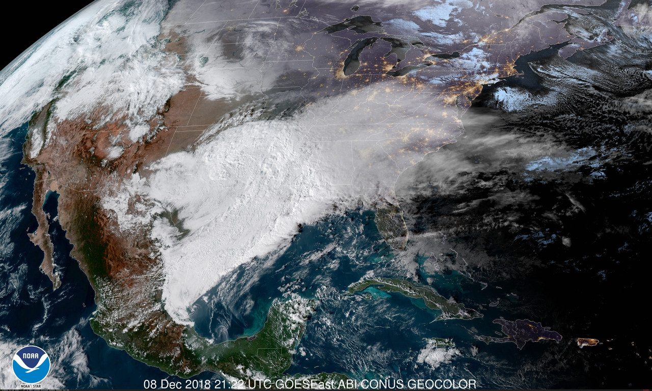
Meanwhile, impressive troughing carved across the entire Eastern CONUS today. You can see the upper shortwave/trough on the water vapor imagery dropping out of the Southern Plains (Southern OK, Red River Valley Region) currently. This is rounding the base of the upper trough and will move through the Deep South the next 24-30 hours from now, then finally off the Southeast U.S. coast by late tomorrow night.

0 likes
NEVER, EVER SAY NEVER in the tropics and weather in general, and most importantly, with life itself!!
________________________________________________________________________________________
Fay 2008 Beryl 2012 Debby 2012 Colin 2016 Hermine 2016 Julia 2016 Matthew 2016 Irma 2017 Dorian 2019
________________________________________________________________________________________
Fay 2008 Beryl 2012 Debby 2012 Colin 2016 Hermine 2016 Julia 2016 Matthew 2016 Irma 2017 Dorian 2019
-
northjaxpro
- S2K Supporter
- Posts: 8900
- Joined: Mon Sep 27, 2010 11:21 am
- Location: Jacksonville, FL
Re: Deep South/Southeastern US Winter 2018-19 (GA, SC, NC, TN, FL, AL, MS, LA)
I think overall the models did a fairly good job with this storm. Initially, both of these models forecasted significant snowfall totals more than 6 inches+ of snow across the extreme Southern NC Piedmont region 48 hours before the event. However, NAM and GFS both picked up on the trend of heavy snow shifting north primarily over the NW NC Piedmont into Virginia 24-30 hours before the start of the event. This was due to the warm nose aloft over extreme Southern NC Piedmont region. The NAM forecast snowfall totals within 12-24 hours before the event across the region turned out to be reasonably done pretty good all things considered. I admit, I love the NAM during winter time synoptics. It is a solid model for this time of year.
1 likes
NEVER, EVER SAY NEVER in the tropics and weather in general, and most importantly, with life itself!!
________________________________________________________________________________________
Fay 2008 Beryl 2012 Debby 2012 Colin 2016 Hermine 2016 Julia 2016 Matthew 2016 Irma 2017 Dorian 2019
________________________________________________________________________________________
Fay 2008 Beryl 2012 Debby 2012 Colin 2016 Hermine 2016 Julia 2016 Matthew 2016 Irma 2017 Dorian 2019
Re: Deep South/Southeastern US Winter 2018-19 (GA, SC, NC, TN, FL, AL, MS, LA)
Thanks for all your analysis and for keeping up with the weather up here in the Carolinas NorthJaxPro!! The storm definitely delivered!! My area got around 10 inches of snow, including a second round of snow on monday morning. It has been a winter wonderland up here, wow! definitely looking a lot like Christmas lol 
1 likes
Georges '98, Irene '99, Frances '04, Jeanne '04, Katrina '05, Wilma '05, Gustav '08, Isaac '12, Matthew '16, Florence '18, Michael '18, Ian '22
Re: Deep South/Southeastern US Winter 2018-19 (GA, SC, NC, TN, FL, AL, MS, LA)
The 18Z GFS shows more of the wraparound moisture mixing with snow for central and northern MS/AL than the previous runs with that low forming at the base of the trough. And we're only 3 days out now. It might not be much but I like the trends so far and hope it continues into the winter.
1 likes
-
northjaxpro
- S2K Supporter
- Posts: 8900
- Joined: Mon Sep 27, 2010 11:21 am
- Location: Jacksonville, FL
Re: Deep South/Southeastern US Winter 2018-19 (GA, SC, NC, TN, FL, AL, MS, LA)
It would not be a complete surprise in situations like this one to see some snowflakes mixed in with the rain. It definitely will be too warm at the surface, so no problems with accumulation of any sort with this system. This extreme cold core upper low has a very cold air column aloft, so that air could get pulled down briefly before that upper trough moves away from MS/AL to the northeast by late Friday afternoon.
1 likes
NEVER, EVER SAY NEVER in the tropics and weather in general, and most importantly, with life itself!!
________________________________________________________________________________________
Fay 2008 Beryl 2012 Debby 2012 Colin 2016 Hermine 2016 Julia 2016 Matthew 2016 Irma 2017 Dorian 2019
________________________________________________________________________________________
Fay 2008 Beryl 2012 Debby 2012 Colin 2016 Hermine 2016 Julia 2016 Matthew 2016 Irma 2017 Dorian 2019
-
northjaxpro
- S2K Supporter
- Posts: 8900
- Joined: Mon Sep 27, 2010 11:21 am
- Location: Jacksonville, FL
Re: Deep South/Southeastern US Winter 2018-19 (GA, SC, NC, TN, FL, AL, MS, LA)
I talked about this in the Florida Weather thread yesterday about this possibility, but this is definitely worthy of mention now here.
This morning's 06Z GFS run is showing a very interesting potential regarding timing coming together with the arctic front dropping south toward the Gulf Coast, and then catching up to the southern jet stream energy and moisture across the Deep South in 264 hours from now.
This run depicts a rather good swath of all light to moderate snow across portions of Alabama. all of Georgia, and south possibly into extreme Florida Panhandle and North Florida. The swath then extends.northeast through the Carolinas. No question thermal profiles all would indicate precip in the form of snow analyzing this run.
This is the potential scenario I have been anticipating over this region with this El Nino type pattern, and sure enough, we may get it early next week. The GFS has been performing well this winter so far with the recent big storms we have seen impact the Deep South the past few weeks.
This is only one run, but it is an encouraging sign for those like me who would like to see a bit of wintry weather deep down in Dixie!!
The interesting thing about this potential next week, should it occur, would take place exactly one year ago to the time of the Southeast Georgia Winter Storm, which I tracked in its entire evolution, and then took the quick 1 hour or so road trip from here to see the snow in Darien, Ga, about 50 miles south of Savannah, last January 3, 2018.
0 likes
NEVER, EVER SAY NEVER in the tropics and weather in general, and most importantly, with life itself!!
________________________________________________________________________________________
Fay 2008 Beryl 2012 Debby 2012 Colin 2016 Hermine 2016 Julia 2016 Matthew 2016 Irma 2017 Dorian 2019
________________________________________________________________________________________
Fay 2008 Beryl 2012 Debby 2012 Colin 2016 Hermine 2016 Julia 2016 Matthew 2016 Irma 2017 Dorian 2019
-
northjaxpro
- S2K Supporter
- Posts: 8900
- Joined: Mon Sep 27, 2010 11:21 am
- Location: Jacksonville, FL
Re: Deep South/Southeastern US Winter 2018-19 (GA, SC, NC, TN, FL, AL, MS, LA)
Timing will be everything, but the run shows a potential of snow across the Deep South next week, especially. the January 3-5. time frame.
12Z EURO is also similar to the GFS solution as well. So, if these trends continue, much colder temps are coming and chances are gradually increasing that another potential significant winter event could impact the Deep South region late next week.
0 likes
NEVER, EVER SAY NEVER in the tropics and weather in general, and most importantly, with life itself!!
________________________________________________________________________________________
Fay 2008 Beryl 2012 Debby 2012 Colin 2016 Hermine 2016 Julia 2016 Matthew 2016 Irma 2017 Dorian 2019
________________________________________________________________________________________
Fay 2008 Beryl 2012 Debby 2012 Colin 2016 Hermine 2016 Julia 2016 Matthew 2016 Irma 2017 Dorian 2019
-
northjaxpro
- S2K Supporter
- Posts: 8900
- Joined: Mon Sep 27, 2010 11:21 am
- Location: Jacksonville, FL
Re: Deep South/Southeastern US Winter 2018-19 (GA, SC, NC, TN, FL, AL, MS, LA)
The models in the past 36 hours have done an about face with regards to the rather complex pattern right now. GFS, EURO, and even the Canadian model, all for now have dropped the solutions showing a potential of wintry precip across the Deep South for next week.
It seems that the GFS is now hinting at cooler, but drier northwesterly, continental flow, mainly across the Eastern CONUS region, starting into the first week of January. The same time period next week, the EURO keeps signaling the continuance of an active southern stream pattern that we have had since the beginning of November.
Well, that is quite a spread and difference the models have displayed just since Monday. I have learned through my past experiences that when the models are in such disagreement like this is not to put any faith into any of them past 5 days. Period!
I will visit back here of course if the models find some semblence of agreement on the pattern evolution as we are about to start January. There has been so much talk and anticipation regarding the sudden stratospheric warming event, which is speculated to happen during this 'upcoming January-February time period. We shall see how this will evolve as time progresses.
1 likes
NEVER, EVER SAY NEVER in the tropics and weather in general, and most importantly, with life itself!!
________________________________________________________________________________________
Fay 2008 Beryl 2012 Debby 2012 Colin 2016 Hermine 2016 Julia 2016 Matthew 2016 Irma 2017 Dorian 2019
________________________________________________________________________________________
Fay 2008 Beryl 2012 Debby 2012 Colin 2016 Hermine 2016 Julia 2016 Matthew 2016 Irma 2017 Dorian 2019
-
northjaxpro
- S2K Supporter
- Posts: 8900
- Joined: Mon Sep 27, 2010 11:21 am
- Location: Jacksonville, FL
Re: Deep South/Southeastern US Winter 2018-19 (GA, SC, NC, TN, FL, AL, MS, LA)
Well, there appears to be enough agreement with a few of the reliable models going out through 168 hours at least for now, as they are bringing back potential of wintry weather for some portions of extreme Deep South on Wednesday into Thursday of next week (1/2- 1/3).
The last 3 consecutive runs of the Operational GFS, including this morning's 06Z, the last 2 runs up through last night's 00Z GEM showing a possible light wintry mix across extreme southern portions of LA, MS, AL, GA and northeast into portions of the Carolinas.
A very, slow moving cold front will be sinking south, as it will be interacting with the southern jet stream during this time frame. Disturbances traversing along the jet will bring some rain along and just ahead of the cold front.. Pretty good modified Arctic High Pressure shown with this incoming air mass, 1036 mb., pushing down toward the ARK/LA/TX region by the end of this specified time period.(next Wednesday evening 1/3) There could be enough moisture overrunning over the cold air along the frontal boundary in those areas mentioned just above..
Awaiting the 12Z EURO later this morning...
0 likes
NEVER, EVER SAY NEVER in the tropics and weather in general, and most importantly, with life itself!!
________________________________________________________________________________________
Fay 2008 Beryl 2012 Debby 2012 Colin 2016 Hermine 2016 Julia 2016 Matthew 2016 Irma 2017 Dorian 2019
________________________________________________________________________________________
Fay 2008 Beryl 2012 Debby 2012 Colin 2016 Hermine 2016 Julia 2016 Matthew 2016 Irma 2017 Dorian 2019
-
northjaxpro
- S2K Supporter
- Posts: 8900
- Joined: Mon Sep 27, 2010 11:21 am
- Location: Jacksonville, FL
Re: Deep South/Southeastern US Winter 2018-19 (GA, SC, NC, TN, FL, AL, MS, LA)
The latest EURO indeed is showing areas across Louisiana, Mississippi, and east into North Alabama picking up snowfall/sleet acculations up to 2 inches in spots January 2- 3.
GFS FV3 is even more bullish than the Operational GFS with regards to wintry precip coverage area as well.
GFS FV3 is even more bullish than the Operational GFS with regards to wintry precip coverage area as well.
0 likes
NEVER, EVER SAY NEVER in the tropics and weather in general, and most importantly, with life itself!!
________________________________________________________________________________________
Fay 2008 Beryl 2012 Debby 2012 Colin 2016 Hermine 2016 Julia 2016 Matthew 2016 Irma 2017 Dorian 2019
________________________________________________________________________________________
Fay 2008 Beryl 2012 Debby 2012 Colin 2016 Hermine 2016 Julia 2016 Matthew 2016 Irma 2017 Dorian 2019
-
MississippiWx

- S2K Supporter
- Posts: 1535
- Joined: Sat Aug 14, 2010 1:44 pm
- Location: Hattiesburg, Mississippi
Re: Deep South/Southeastern US Winter 2018-19 (GA, SC, NC, TN, FL, AL, MS, LA)
northjaxpro wrote:The latest EURO indeed is showing areas across Louisiana, Mississippi, and east into North Alabama picking up snowfall/sleet acculations up to 2 inches in spots January 2- 3.
GFS FV3 is even more bullish than the Operational GFS with regards to wintry precip coverage area as well.
The weather.us site does not show any accumulation in those areas at that time.
0 likes
This post is not an official forecast and should not be used as such. It is just the opinion of MississippiWx and may or may not be backed by sound meteorological data. It is not endorsed by any professional institution including storm2k.org. For Official Information please refer to the NHC and NWS products.
-
northjaxpro
- S2K Supporter
- Posts: 8900
- Joined: Mon Sep 27, 2010 11:21 am
- Location: Jacksonville, FL
Re: Deep South/Southeastern US Winter 2018-19 (GA, SC, NC, TN, FL, AL, MS, LA)
MississippiWx wrote:northjaxpro wrote:The latest EURO indeed is showing areas across Louisiana, Mississippi, and east into North Alabama picking up snowfall/sleet acculations up to 2 inches in spots January 2- 3.
GFS FV3 is even more bullish than the Operational GFS with regards to wintry precip coverage area as well.
The weather.us site does not show any accumulation in those areas at that time.
I can not explain why that is happening on that site. It should pull up by date and time frame of the run and the region and or state you are looking for regarding the EURO. I use it at times, but mostly I utilize Weatherbell. I understand weather.us is free for use though, so I definitely of course see many using that site.
0 likes
NEVER, EVER SAY NEVER in the tropics and weather in general, and most importantly, with life itself!!
________________________________________________________________________________________
Fay 2008 Beryl 2012 Debby 2012 Colin 2016 Hermine 2016 Julia 2016 Matthew 2016 Irma 2017 Dorian 2019
________________________________________________________________________________________
Fay 2008 Beryl 2012 Debby 2012 Colin 2016 Hermine 2016 Julia 2016 Matthew 2016 Irma 2017 Dorian 2019
-
northjaxpro
- S2K Supporter
- Posts: 8900
- Joined: Mon Sep 27, 2010 11:21 am
- Location: Jacksonville, FL
Re: Deep South/Southeastern US Winter 2018-19 (GA, SC, NC, TN, FL, AL, MS, LA)
The models, in particular the GFS FV3 06Z earlier this morning, showing decent snowfall accumulations across the ARK/LA/TEX area, eastward into western TN and Northern MS to beginning late Wednesday Jan 2 into January 3. A significant shortwave southern stream disturbance will be moving through the region middle to latter part of this upcoming week.
Amounts of up to 4+ inches , and isolated potential of even higher amounts, are being shown in a few spots in the areas specified by the end if this event in the Mid-South region by Friday.
Amounts of up to 4+ inches , and isolated potential of even higher amounts, are being shown in a few spots in the areas specified by the end if this event in the Mid-South region by Friday.
0 likes
NEVER, EVER SAY NEVER in the tropics and weather in general, and most importantly, with life itself!!
________________________________________________________________________________________
Fay 2008 Beryl 2012 Debby 2012 Colin 2016 Hermine 2016 Julia 2016 Matthew 2016 Irma 2017 Dorian 2019
________________________________________________________________________________________
Fay 2008 Beryl 2012 Debby 2012 Colin 2016 Hermine 2016 Julia 2016 Matthew 2016 Irma 2017 Dorian 2019
Who is online
Users browsing this forum: No registered users and 26 guests