ENSO Updates (2007 thru 2023)

This is the general tropical discussion area. Anyone can take their shot at predicting a storms path.

Moderator: S2k Moderators

Forum rules

The posts in this forum are NOT official forecasts and should not be used as such. They are just the opinion of the poster and may or may not be backed by sound meteorological data. They are NOT endorsed by any professional institution or STORM2K. For official information, please refer to products from the National Hurricane Center and National Weather Service.

Help Support Storm2K
Message
Author
User avatar
Kingarabian
S2K Supporter
S2K Supporter
Posts: 15432
Joined: Sat Aug 08, 2009 3:06 am
Location: Honolulu, Hawaii

Re: ENSO Updates

#10241 Postby Kingarabian » Sat Feb 09, 2019 3:28 pm

CyclonicFury wrote:
Shell Mound wrote:If we are going to see a full-blown El Niño in 2019, we may as well seek another super Niño à la 2015-16. A very strong WWB could significantly strengthen the subsurface warm pool. If this upcoming WWB were to fully materialise, then I would definitely expect not just El Niño, but also a potentially strong or even very strong event. Since 2015-16, the Pacific seems to have entered into a subsurface phase that retains more heat than previously, and thus makes stronger and/or more persistent El Niño events more plausible, at least when other factors line up.

I highly doubt that. Super El Niño events are rare and it would be quite unusual to see another super Niño so soon. But has the Pacific really entered a state that makes El Niño more likely? El Niño busted in 2017 and struggled to get going in 2018.


The thing is, 2017 and 2018 shouldn't have even been in consideration to be El Nino years. So even if they struggled/busted in attaining El Nino status, the fact that there was a possibility is eyebrow raising.
1 likes   
RIP Kobe Bryant

User avatar
Kingarabian
S2K Supporter
S2K Supporter
Posts: 15432
Joined: Sat Aug 08, 2009 3:06 am
Location: Honolulu, Hawaii

Re: ENSO Updates

#10242 Postby Kingarabian » Sat Feb 09, 2019 3:37 pm

Shell Mound wrote:If we are going to see a full-blown El Niño in 2019, we may as well seek another super Niño à la 2015-16. A very strong WWB could significantly strengthen the subsurface warm pool. If this upcoming WWB were to fully materialise, then I would definitely expect not just El Niño, but also a potentially strong or even very strong event. Since 2015-16, the Pacific seems to have entered into a subsurface phase that retains more heat than previously, and thus makes stronger and/or more persistent El Niño events more plausible, at least when other factors line up.


It is possible that we may be seeing something serious forming. It's also just as possible that nothing materializes considering how 2017 and 2018 went.

If I'm reading the subsurface correct, the late February/March WWB that triggered the 2015 super El Nino did not have the subsurface as warm as we currently do. So with this WWB event looking to be as strong or stronger than the one in early spring of 2015, there is great potential for 2019 to be an El Nino year if everything materializes and we get continued atmospheric coupling.
2 likes   
RIP Kobe Bryant

Ntxw
Storm2k Moderator
Storm2k Moderator
Posts: 21492
Joined: Wed Oct 21, 2009 6:34 pm
Location: DFW, Texas

Re: ENSO Updates

#10243 Postby Ntxw » Sat Feb 09, 2019 3:44 pm

I think the better question to ask is how the warming overall of the tropical Pacific has wrecked havoc on usual indicators of ENSO. 28C+ is usually reserved for the WPAC and Indonesia but now frequents the central and east Pacific that throws confusion on the walker circulation. We have to put aside "anomalies" for a moment and think in terms of actually SSTs. 28C is important as it is the threshold to sustain tropical convection. How will the atmosphere react when both the maritime and Pacific lights up with thunderstorms releasing mass amounts of heat and energy? In the past usually it is one or the other but we are now seeing more often conflicting signals.
2 likes   
The above post and any post by Ntxw is NOT an official forecast and should not be used as such. It is just the opinion of the poster and may or may not be backed by sound meteorological data. It is NOT endorsed by any professional institution including Storm2k. For official information, please refer to NWS products.

  Help support Storm2K!
Help Support Storm2K

User avatar
Kingarabian
S2K Supporter
S2K Supporter
Posts: 15432
Joined: Sat Aug 08, 2009 3:06 am
Location: Honolulu, Hawaii

Re: ENSO Updates

#10244 Postby Kingarabian » Sat Feb 09, 2019 3:48 pm

Ntxw wrote:I think the better question to ask is how the warming overall of the tropical Pacific has wrecked havoc on usual indicators of ENSO. 28C+ is usually reserved for the WPAC and Indonesia but now frequents the central and east Pacific that throws confusion on the walker circulation. We have to put aside "anomalies" for a moment and think in terms of actually SSTs. 28C is important as it is the threshold to sustain tropical convection. How will the atmosphere react when both the maritime and Pacific lights up with thunderstorms releasing mass amounts of heat and energy? In the past usually it is one or the other but we are now seeing more often conflicting signals.


If we continue to see 28C+ across the Pacific ocean then I'm assuming all the rising air will stay there and the sinking motion will spread into the Atlantic and Indian Ocean.
0 likes   
RIP Kobe Bryant

User avatar
Kingarabian
S2K Supporter
S2K Supporter
Posts: 15432
Joined: Sat Aug 08, 2009 3:06 am
Location: Honolulu, Hawaii

Re: ENSO Updates

#10245 Postby Kingarabian » Sat Feb 09, 2019 3:52 pm

Euro February update, the member mean pretty much shows neutral ENSO conditions for the hurricane season.

Image
1 likes   
RIP Kobe Bryant

User avatar
cycloneye
Admin
Admin
Posts: 139011
Age: 67
Joined: Thu Oct 10, 2002 10:54 am
Location: San Juan, Puerto Rico

Re: ENSO Updates

#10246 Postby cycloneye » Sat Feb 09, 2019 6:17 pm

Ventrice has a Twitter thread that confirms above comments about the WWB and more important,atmosphere is coinciding now.

 https://twitter.com/MJVentrice/status/1094369914939498496


 https://twitter.com/MJVentrice/status/1094370355165233152


2 likes   
Visit the Caribbean-Central America Weather Thread where you can find at first post web cams,radars
and observations from Caribbean basin members Click Here

User avatar
Kingarabian
S2K Supporter
S2K Supporter
Posts: 15432
Joined: Sat Aug 08, 2009 3:06 am
Location: Honolulu, Hawaii

Re: ENSO Updates

#10247 Postby Kingarabian » Sat Feb 09, 2019 6:42 pm

Yup, the Euro is showing a pretty substantial WWB as well and relaxed trades across the entire EPAC basin.
2 likes   
RIP Kobe Bryant

User avatar
NotSparta
Professional-Met
Professional-Met
Posts: 1645
Age: 22
Joined: Fri Aug 18, 2017 8:24 am
Location: Naples, FL
Contact:

Re: ENSO Updates

#10248 Postby NotSparta » Sun Feb 10, 2019 7:36 am

Shell Mound wrote:If we are going to see a full-blown El Niño in 2019, we may as well seek another super Niño à la 2015-16. A very strong WWB could significantly strengthen the subsurface warm pool. If this upcoming WWB were to fully materialise, then I would definitely expect not just El Niño, but also a potentially strong or even very strong event. Since 2015-16, the Pacific seems to have entered into a subsurface phase that retains more heat than previously, and thus makes stronger and/or more persistent El Niño events more plausible, at least when other factors line up.


2019 is missing a whole lot for a super Niño. It's such an extreme conclusion that even in February it's pretty easy to rule out
0 likes   
This post was probably an opinion of mine, and in no way is official. Please refer to http://www.hurricanes.gov for official tropical analysis and advisories.

My website, with lots of tropical wx graphics, including satellite and recon: http://cyclonicwx.com

User avatar
NotSparta
Professional-Met
Professional-Met
Posts: 1645
Age: 22
Joined: Fri Aug 18, 2017 8:24 am
Location: Naples, FL
Contact:

Re: ENSO Updates

#10249 Postby NotSparta » Sun Feb 10, 2019 7:38 am

cycloneye wrote:Ventrice has a Twitter thread that confirms above comments about the WWB and more important,atmosphere is coinciding now.

https://twitter.com/MJVentrice/status/1094369914939498496

https://twitter.com/MJVentrice/status/1094370355165233152


Still there, but isn't as extreme on euro
0 likes   
This post was probably an opinion of mine, and in no way is official. Please refer to http://www.hurricanes.gov for official tropical analysis and advisories.

My website, with lots of tropical wx graphics, including satellite and recon: http://cyclonicwx.com

User avatar
Kingarabian
S2K Supporter
S2K Supporter
Posts: 15432
Joined: Sat Aug 08, 2009 3:06 am
Location: Honolulu, Hawaii

Re: ENSO Updates

#10250 Postby Kingarabian » Sun Feb 10, 2019 1:35 pm

NotSparta wrote:
cycloneye wrote:Ventrice has a Twitter thread that confirms above comments about the WWB and more important,atmosphere is coinciding now.

https://twitter.com/MJVentrice/status/1094369914939498496

https://twitter.com/MJVentrice/status/1094370355165233152


Still there, but isn't as extreme on euro

Its large and strong on the Euro. The GFS is sinply extreme.
2 likes   
RIP Kobe Bryant

User avatar
cycloneye
Admin
Admin
Posts: 139011
Age: 67
Joined: Thu Oct 10, 2002 10:54 am
Location: San Juan, Puerto Rico

Re: ENSO: CPC Weekly update of 2/11/19: Niño 3.4 up to +0.4C

#10251 Postby cycloneye » Mon Feb 11, 2019 9:53 am

The CPC weekly update has Niño 3.4 going up from +0.3C last week to now +0.4C.

Note=The always important CPC monthly update will be up on Thursday the 14th. Let's see if they issue El Niño Advisory.

https://www.cpc.ncep.noaa.gov/products/ ... ts-web.pdf
1 likes   
Visit the Caribbean-Central America Weather Thread where you can find at first post web cams,radars
and observations from Caribbean basin members Click Here

User avatar
cycloneye
Admin
Admin
Posts: 139011
Age: 67
Joined: Thu Oct 10, 2002 10:54 am
Location: San Juan, Puerto Rico

Re: ENSO: CPC Weekly update of 2/11/19: Niño 3.4 up to +0.4C

#10252 Postby cycloneye » Mon Feb 11, 2019 11:38 am

0 likes   
Visit the Caribbean-Central America Weather Thread where you can find at first post web cams,radars
and observations from Caribbean basin members Click Here

User avatar
CyclonicFury
Category 5
Category 5
Posts: 1970
Age: 25
Joined: Sun Jul 02, 2017 12:32 pm
Location: NC
Contact:

Re: ENSO: CPC Weekly update of 2/11/19: Niño 3.4 up to +0.4C

#10253 Postby CyclonicFury » Mon Feb 11, 2019 11:48 am

cycloneye wrote:The CPC weekly update has Niño 3.4 going up from +0.3C last week to now +0.4C.

Note=The always important CPC monthly update will be up on Thursday the 14th. Let's see if they issue El Niño Advisory.

https://www.cpc.ncep.noaa.gov/products/ ... ts-web.pdf

With several recently weekly values below +0.5C I don't think they will issue the El Niño advisory yet. Maybe March if the WWB materializes as shown as models.
1 likes   
NCSU B.S. in Meteorology Class of 2021. Tropical weather blogger at http://www.cyclonicfury.com. My forecasts and thoughts are NOT official, for official forecasts please consult the National Hurricane Center.

Ntxw
Storm2k Moderator
Storm2k Moderator
Posts: 21492
Joined: Wed Oct 21, 2009 6:34 pm
Location: DFW, Texas

Re: ENSO: CPC Weekly update of 2/11/19: Niño 3.4 up to +0.4C

#10254 Postby Ntxw » Mon Feb 11, 2019 11:53 am

CyclonicFury wrote:
cycloneye wrote:The CPC weekly update has Niño 3.4 going up from +0.3C last week to now +0.4C.

Note=The always important CPC monthly update will be up on Thursday the 14th. Let's see if they issue El Niño Advisory.

https://www.cpc.ncep.noaa.gov/products/ ... ts-web.pdf

With several recently weekly values below +0.5C I don't think they will issue the El Niño advisory yet. Maybe March if the WWB materializes as shown as models.


ONI is the standard. The most recent ONI (with cooler weeklies) still read 0.8C. It is well above, the next one may come in at 0.6C so it will be more than enough.
0 likes   
The above post and any post by Ntxw is NOT an official forecast and should not be used as such. It is just the opinion of the poster and may or may not be backed by sound meteorological data. It is NOT endorsed by any professional institution including Storm2k. For official information, please refer to NWS products.


  Help support Storm2K!

Help Support Storm2K


Ntxw
Storm2k Moderator
Storm2k Moderator
Posts: 21492
Joined: Wed Oct 21, 2009 6:34 pm
Location: DFW, Texas

Re: ENSO: CPC Weekly update of 2/11/19: Niño 3.4 up to +0.4C

#10255 Postby Ntxw » Mon Feb 11, 2019 11:54 am

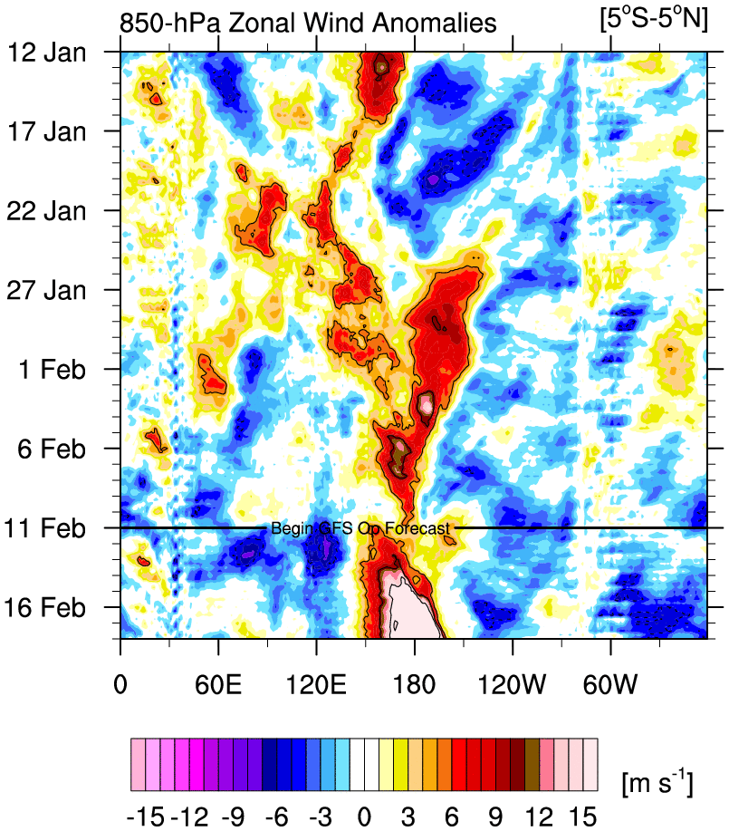
WWB coming is a big one.

Image
2 likes   
The above post and any post by Ntxw is NOT an official forecast and should not be used as such. It is just the opinion of the poster and may or may not be backed by sound meteorological data. It is NOT endorsed by any professional institution including Storm2k. For official information, please refer to NWS products.


  Help support Storm2K!

Help Support Storm2K


Ntxw
Storm2k Moderator
Storm2k Moderator
Posts: 21492
Joined: Wed Oct 21, 2009 6:34 pm
Location: DFW, Texas

Re: ENSO: CPC Weekly update of 2/11/19: Niño 3.4 up to +0.4C

#10256 Postby Ntxw » Mon Feb 11, 2019 12:01 pm

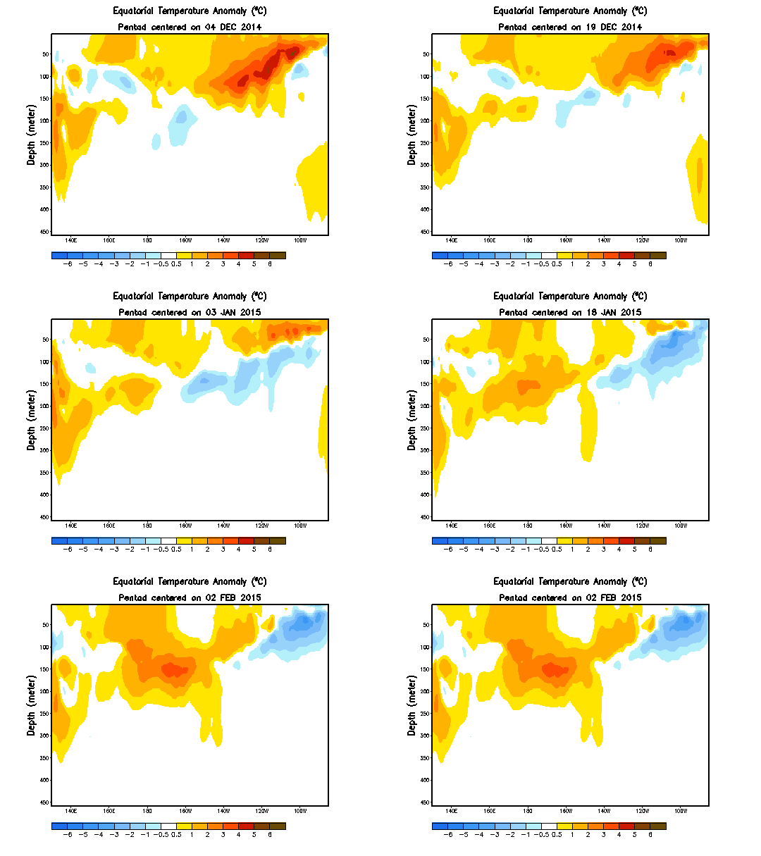
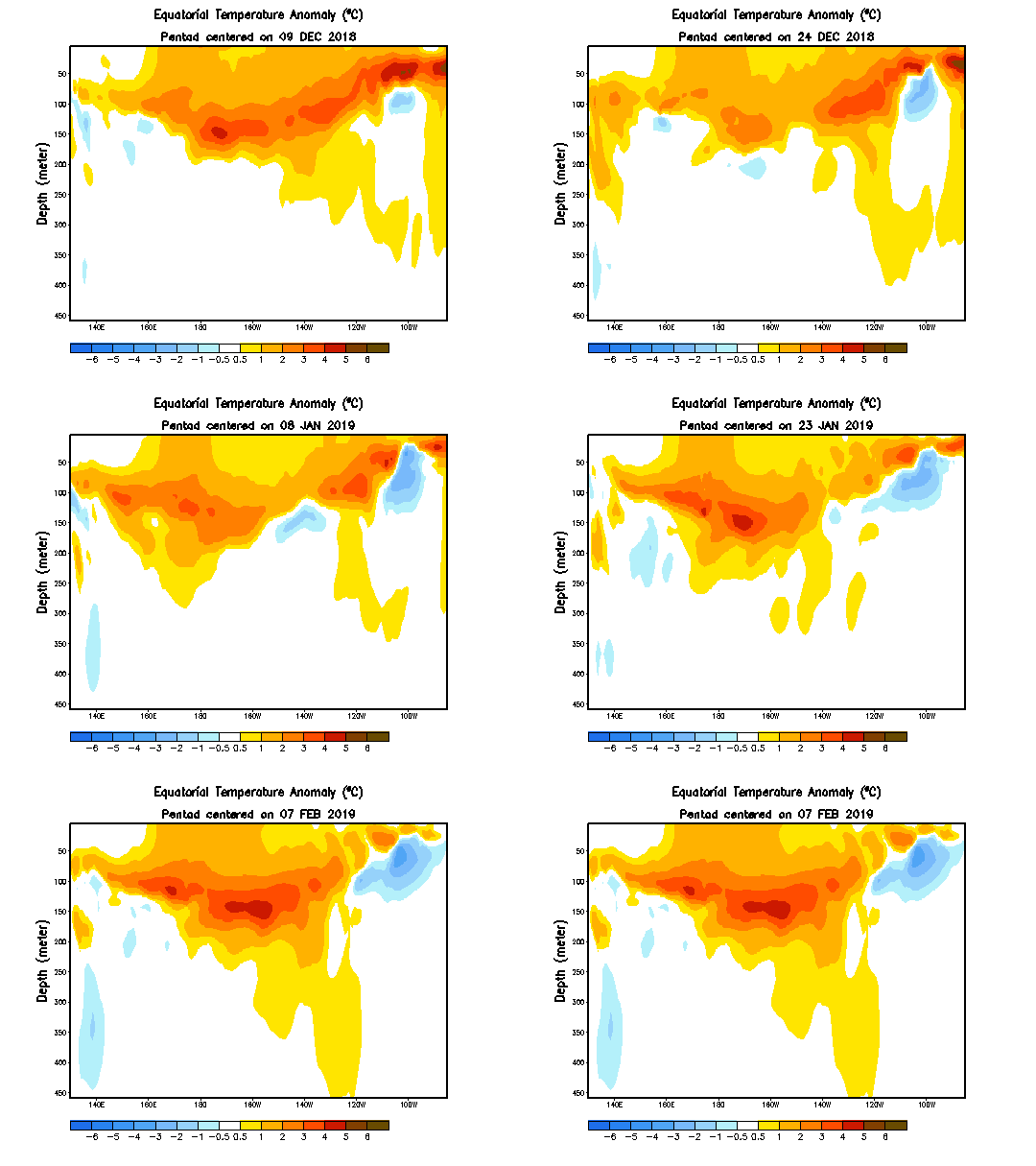
Kind of Eerie the sluggish Nino resembles 2014-2015 and now we are sitting in a close thermocline transformation as 2015. I don't think we will go Super but a 1987-1988-like second year event is not impossible.

Image

Image
3 likes   
The above post and any post by Ntxw is NOT an official forecast and should not be used as such. It is just the opinion of the poster and may or may not be backed by sound meteorological data. It is NOT endorsed by any professional institution including Storm2k. For official information, please refer to NWS products.


  Help support Storm2K!

Help Support Storm2K


User avatar
Kingarabian
S2K Supporter
S2K Supporter
Posts: 15432
Joined: Sat Aug 08, 2009 3:06 am
Location: Honolulu, Hawaii

Re: ENSO: CPC Weekly update of 2/11/19: Niño 3.4 up to +0.4C

#10257 Postby Kingarabian » Mon Feb 11, 2019 2:24 pm

cycloneye wrote:ECMWF WWB forecast not as strong as GFS.

That's because the GFS has higher amplification in phase 8 and spends more time in phase 8 compared to the Euro.

GFS:
Image

Euro:
Image

CFS:
Image

However Euro spends decent time in phase 8 and then goes into phase 1, which is why you see a solid and strong WWB over the dateline, and very relaxed trades across the entire EPAC, vs. just an extreme WWB over the dateline. Both the Euro and GFS zonal wind depictions help El Nino formation.
2 likes   
RIP Kobe Bryant

User avatar
Kingarabian
S2K Supporter
S2K Supporter
Posts: 15432
Joined: Sat Aug 08, 2009 3:06 am
Location: Honolulu, Hawaii

Re: ENSO: CPC Weekly update of 2/11/19: Niño 3.4 up to +0.4C

#10258 Postby Kingarabian » Mon Feb 11, 2019 2:28 pm

Ntxw wrote:Kind of Eerie the sluggish Nino resembles 2014-2015 and now we are sitting in a close thermocline transformation as 2015. I don't think we will go Super but a 1987-1988-like second year event is not impossible.

[url]https://images2.imgbox.com/21/fe/iJcKcZgx_o.gif[url]

[url]https://images2.imgbox.com/42/44/RGFyPGUP_o.gif[url]


Yeah and there is warmer anomalies this year compared to 2015 through February. I wonder what kind of subsurface anomalies we will see come March and April.
1 likes   
RIP Kobe Bryant

User avatar
Kingarabian
S2K Supporter
S2K Supporter
Posts: 15432
Joined: Sat Aug 08, 2009 3:06 am
Location: Honolulu, Hawaii

Re: ENSO: CPC Weekly update of 2/11/19: Niño 3.4 up to +0.4C

#10259 Postby Kingarabian » Mon Feb 11, 2019 2:30 pm

0 likes   
RIP Kobe Bryant

User avatar
Kingarabian
S2K Supporter
S2K Supporter
Posts: 15432
Joined: Sat Aug 08, 2009 3:06 am
Location: Honolulu, Hawaii

Re: ENSO: CPC Weekly update of 2/11/19: Niño 3.4 up to +0.4C

#10260 Postby Kingarabian » Mon Feb 11, 2019 3:09 pm

It's incredible that from 2014-2019, only 2016 was never in contention to be an El Nino.
1 likes   
RIP Kobe Bryant


Return to “Talkin' Tropics”

Who is online

Users browsing this forum: Beef Stew, KirbyDude25, Stormybajan, tolakram and 69 guests