ENSO Updates (2007 thru 2023)

This is the general tropical discussion area. Anyone can take their shot at predicting a storms path.

Moderator: S2k Moderators

Forum rules

The posts in this forum are NOT official forecasts and should not be used as such. They are just the opinion of the poster and may or may not be backed by sound meteorological data. They are NOT endorsed by any professional institution or STORM2K. For official information, please refer to products from the National Hurricane Center and National Weather Service.

Help Support Storm2K
Message
Author
User avatar
StruThiO
Category 3
Category 3
Posts: 821
Age: 24
Joined: Fri Sep 15, 2017 5:51 am
Location: Currently Portland, OR. Raised in Jax, FL.

Re: ENSO: CPC March Update: El Niño to last thru Summer

#10381 Postby StruThiO » Thu Mar 14, 2019 3:09 pm


monthly blog post

https://www.climate.gov/news-features/b ... ink-spring

edit: excerpt

The state of the tropical Pacific in early 2019 has some eerie similarities to that of early 2015. After several months of warmer-than-average sea surface temperatures, the atmosphere responded with weak El Niño conditions, similar to 2015. And, a downwelling Kelvin wave is present, as in 2015. Many climate models are predicting that sea surface temperatures will remain elevated through the year.

So are we in for another 2015-style strong El Niño? Even with now and then having so much in common, it’s far too soon to tell. Climate models are notoriously unreliable when making predictions in March and April, when ENSO is often in transition. As this graph of climate model forecasts shows, the range of potential outcomes is huge, and includes everything from a moderate La Niña through a stronger El Niño. This huge range tells us that the climate models do not have much agreement about what will happen next fall.

Also, wind patterns and heat content in March are not very powerful predictors of fall El Niño patterns. While it’s likely that the current weak El Niño conditions will continue through the summer, as Michelle said in 2015, “there are still plenty of innings left to play.” Hopefully, we’ll have a clearer picture of next fall after the spring predictability barrier is behind us.
1 likes   

User avatar
Kingarabian
S2K Supporter
S2K Supporter
Posts: 15432
Joined: Sat Aug 08, 2009 3:06 am
Location: Honolulu, Hawaii

Re: ENSO: CPC March Update: Weak El Niño to last thru Summer

#10382 Postby Kingarabian » Sat Mar 16, 2019 2:43 pm

New WWB event has begun in the WPAC. We've now seen consecutive WWB's since late December. This backs the argument that the atmosphere is Nino coupled (succession of WWB's since late December) and for El Nino to continue into the summer/fall.

Image
Even though there looks to be above average trade activity over the CPAC, these WPAC WWB's usually spread over and slow the trades down. And looking at the past couple of Euro runs, there's a large area of -VP200 anomalies that will move across the CPAC in 5-7 days. So it's very possible we see this WWB carry over into the CPAC and go on through the beginning of April.


This event is currently confined over the WPAC so it will help warm the subsurface beneath the WPAC and maybe trigger another downwelling Kelvin wave, thus keeping the assembly line of warm anomalies moving to the EPAC going.
Image
3 likes   
RIP Kobe Bryant

Ntxw
Storm2k Moderator
Storm2k Moderator
Posts: 21490
Joined: Wed Oct 21, 2009 6:34 pm
Location: DFW, Texas

Re: ENSO: CPC March Update: Weak El Niño to last thru Summer

#10383 Postby Ntxw » Sat Mar 16, 2019 3:43 pm

Kingarabian wrote:This event is currently confined over the WPAC so it will help warm the subsurface beneath the WPAC and maybe trigger another downwelling Kelvin wave, thus keeping the assembly line of warm anomalies moving to the EPAC going.https://i.imgur.com/3JNqqCF.png


This currently does not look at all like a typical transition out of El Nino in early Spring. This is akin to your second year Nino events and onstart of new El Ninos. Your typical El Nino by March has eroded the subsurface with only surface warmth and many times you are already in the process of sloping further the thermocline (Nina building process). Spring barrier this year has relatively low spread compared to usual. Nearly all models (that's worth anything) are in pretty good agreement the Nino persists through Summer at the very least.
3 likes   
The above post and any post by Ntxw is NOT an official forecast and should not be used as such. It is just the opinion of the poster and may or may not be backed by sound meteorological data. It is NOT endorsed by any professional institution including Storm2k. For official information, please refer to NWS products.

  Help support Storm2K!
Help Support Storm2K

User avatar
cycloneye
Admin
Admin
Posts: 139008
Age: 67
Joined: Thu Oct 10, 2002 10:54 am
Location: San Juan, Puerto Rico

Re: ENSO Updates

#10384 Postby cycloneye » Sun Mar 17, 2019 5:56 am

5 likes   
Visit the Caribbean-Central America Weather Thread where you can find at first post web cams,radars
and observations from Caribbean basin members Click Here

User avatar
Kingarabian
S2K Supporter
S2K Supporter
Posts: 15432
Joined: Sat Aug 08, 2009 3:06 am
Location: Honolulu, Hawaii

Re: ENSO Updates

#10385 Postby Kingarabian » Sun Mar 17, 2019 3:05 pm

4 likes   
RIP Kobe Bryant

Hunabku
Tropical Depression
Tropical Depression
Posts: 67
Joined: Sat Apr 16, 2016 1:50 am

Re: ENSO Updates

#10386 Postby Hunabku » Sun Mar 17, 2019 6:42 pm


Ugh Big Joe. :roll: A real scientist would never make this statement "Such events are natural with no linkage to man". That's even more absurd than stating that there is a definitive linkage between the frequency of El Ninos and climate change. Both statements make extraordinary claims and as such require extraordinary evidence.

We do know that AGW has more than doubled planetary ocean heat content change over the last 30 years. However, it would be very difficult to attribute this immense increase in OHC to frequency of Ninos given how little we know about the underlying dynamics, the interrelated cyclical nature of ENSO/PDO, the lack of long-term detailed data sets, etc. Along those lines i'll quote again:
According to a 2012 study by Barnston et al http://journals.ametsoc.org/doi/abs/10. ... 11-00111.1 “results indicate (ENSO forecasting) skills somewhat lower than those found for the less advanced models of the 1980s and 1990s” “This finding” “suggests that decadal variations in the character of ENSO variability are a greater skill-determining factor than the steady but gradual trend toward improved ENSO prediction science and models.”

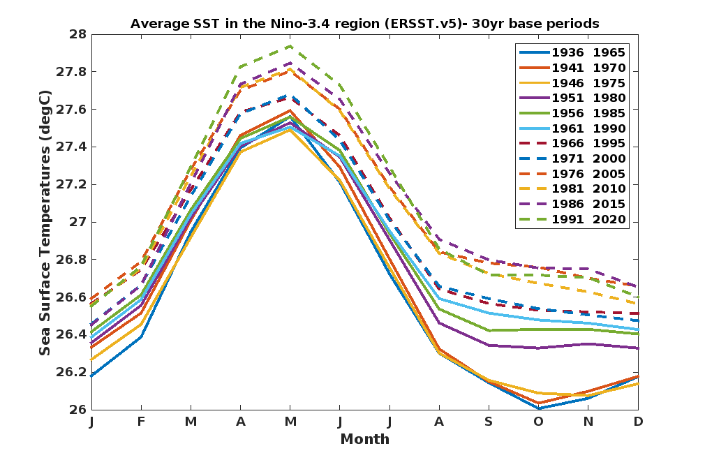
Every five years NOAA updates its primary index for gauging the intensity of ENSO: the sea surface temps of region 3.4. Why? Because of rapidly increasing SSTs a central indicator of climate change:

Due to a significant warming trend in the Niño-3.4 region since 1950, El Niño and La Niña episodes that are defined by a single fixed 30-year base period (e.g. 1971-2000) are increasingly incorporating longer-term trends that do not reflect interannual ENSO variability. In order to remove this warming trend, CPC is adopting a new strategy to update the base period.

There will be multiple centered 30-year base periods that will be used to define the Oceanic Niño index (as a departure from average or "anomaly"). These 30-year base periods will be used to calculate the anomalies for successive 5-year periods in the historical record:
Image


Even with this 30-year averaging increase we've had three super El Ninos in the last 37 years! As mentioned among other reasons the data set is not long enough to establish a definitive connection, but only a fool (or an intentional climate deceiver) would say that there is no connection.
10 likes   

User avatar
Kingarabian
S2K Supporter
S2K Supporter
Posts: 15432
Joined: Sat Aug 08, 2009 3:06 am
Location: Honolulu, Hawaii

Re: ENSO Updates

#10387 Postby Kingarabian » Mon Mar 18, 2019 4:47 am

Large area of +6C anomalies beneath the EPAC on the latest PENTAD/GODAS analysis. Almost as if the easterlies didnt do a thing. Subsurface surely has some 2014/2015 look to it now.
1 likes   
RIP Kobe Bryant

User avatar
cycloneye
Admin
Admin
Posts: 139008
Age: 67
Joined: Thu Oct 10, 2002 10:54 am
Location: San Juan, Puerto Rico

Re: ENSO: CPC Weekly update of 3/18/19: Niño 3.4 remains at +1.0C

#10388 Postby cycloneye » Mon Mar 18, 2019 9:06 am

CPC weekly update of 3/18/19 has Niño 3.4 remaining at +1.0C.

https://www.cpc.ncep.noaa.gov/products/ ... ts-web.pdf
1 likes   
Visit the Caribbean-Central America Weather Thread where you can find at first post web cams,radars
and observations from Caribbean basin members Click Here

User avatar
Kingarabian
S2K Supporter
S2K Supporter
Posts: 15432
Joined: Sat Aug 08, 2009 3:06 am
Location: Honolulu, Hawaii

Re: ENSO: CPC Weekly update of 3/18/19: Niño 3.4 remains at +1.0C

#10389 Postby Kingarabian » Mon Mar 18, 2019 5:07 pm

Looks like the SOI will be fluctuating quite a bit due to twin cyclones near Darwin.
1 likes   
RIP Kobe Bryant

User avatar
StruThiO
Category 3
Category 3
Posts: 821
Age: 24
Joined: Fri Sep 15, 2017 5:51 am
Location: Currently Portland, OR. Raised in Jax, FL.

Re: ENSO: CPC Weekly update of 3/18/19: Niño 3.4 remains at +1.0C

#10390 Postby StruThiO » Mon Mar 18, 2019 5:33 pm

1 likes   

User avatar
Kingarabian
S2K Supporter
S2K Supporter
Posts: 15432
Joined: Sat Aug 08, 2009 3:06 am
Location: Honolulu, Hawaii

Re: ENSO: CPC Weekly update of 3/18/19: Niño 3.4 remains at +1.0C

#10391 Postby Kingarabian » Mon Mar 18, 2019 5:46 pm

StruThiO wrote:Mjo update looks slick lately

https://www.cpc.ncep.noaa.gov/products/ ... update.pdf


Great read. Thanks for sharing.
1 likes   
RIP Kobe Bryant

User avatar
Kingarabian
S2K Supporter
S2K Supporter
Posts: 15432
Joined: Sat Aug 08, 2009 3:06 am
Location: Honolulu, Hawaii

Re: ENSO: CPC Weekly update of 3/18/19: Niño 3.4 remains at +1.0C

#10392 Postby Kingarabian » Mon Mar 18, 2019 6:00 pm

Pretty nice twitter thread in regards to the MJO, why the RMM is showing the MJO dead when it's not, and when will the MJO get into the pacific.

 https://twitter.com/carl_schreck/status/1107699279479664641


Seems like everyone is just waiting for the -VP200 anomalies to hit the Pacific and trigger a WWB to sign off on this El Nino for summer 2019.
3 likes   
RIP Kobe Bryant

User avatar
StruThiO
Category 3
Category 3
Posts: 821
Age: 24
Joined: Fri Sep 15, 2017 5:51 am
Location: Currently Portland, OR. Raised in Jax, FL.

Re: ENSO: CPC Weekly update of 3/18/19: Niño 3.4 remains at +1.0C

#10393 Postby StruThiO » Mon Mar 18, 2019 8:17 pm

Kingarabian wrote:
Seems like everyone is just waiting for the -VP200 anomalies to hit the Pacific and trigger a WWB to sign off on this El Nino for summer 2019.


Image

Well....
2 likes   

User avatar
Kingarabian
S2K Supporter
S2K Supporter
Posts: 15432
Joined: Sat Aug 08, 2009 3:06 am
Location: Honolulu, Hawaii

Re: ENSO: CPC Weekly update of 3/18/19: Niño 3.4 remains at +1.0C

#10394 Postby Kingarabian » Tue Mar 19, 2019 2:12 am

StruThiO wrote:
Kingarabian wrote:
Seems like everyone is just waiting for the -VP200 anomalies to hit the Pacific and trigger a WWB to sign off on this El Nino for summer 2019.


https://i.imgur.com/AzPjj3C.jpg

Well....


I think the graphic will adjust soon. Because like Carl said in his tweet, the models have the MJO in the circle while in reality it's entering the WPAC. So that will effect their 850mb zonal wind forecasts.

Also we're seeing +1.5C popping up near Nino 3.4 on the buoys:
Image
2 likes   
RIP Kobe Bryant

User avatar
cycloneye
Admin
Admin
Posts: 139008
Age: 67
Joined: Thu Oct 10, 2002 10:54 am
Location: San Juan, Puerto Rico

Re: ENSO: BoM 3/19/18 update: El Niño Alert issued

#10395 Postby cycloneye » Tue Mar 19, 2019 5:42 am

BoM issues El Niño Alert

El Niño ALERT; likelihood of El Niño in 2019 increases
The El Niño–Southern Oscillation (ENSO) is currently neutral. The Bureau's ENSO Outlook has moved to El Niño ALERT.

This means the chance of El Niño developing in 2019 has increased to approximately 70%, around triple the normal likelihood.

Tropical Pacific sea surface temperatures have touched on El Niño thresholds for the past three weeks, while waters below the surface are also slightly warmer than average. Signs of El Niño in the atmosphere are less clear. While values of the Southern Oscillation Index (SOI) are currently within El Niño bounds, the index is likely to weaken in the coming days. Large swings in the SOI are not uncommon during the southern hemisphere monsoon season. Additionally, trade winds have been closer to normal over the past fortnight after a period of weakened trades in the western tropical Pacific.

Most international climate models suggest sea surface temperatures in the central tropical Pacific Ocean are likely to remain at El Niño levels into winter. Sustained warmer than average ocean waters would increase the likelihood of coupling between the atmosphere and ocean, which would typically cause changes in Australian and global weather patterns. However, current outlooks have less skill for the period beyond May, and therefore predictions for the latter months should be viewed with some caution.


Image

http://www.bom.gov.au/climate/enso/
1 likes   
Visit the Caribbean-Central America Weather Thread where you can find at first post web cams,radars
and observations from Caribbean basin members Click Here

Hunabku
Tropical Depression
Tropical Depression
Posts: 67
Joined: Sat Apr 16, 2016 1:50 am

Re: ENSO: BoM 3/19/18 update: El Niño Alert issued

#10396 Postby Hunabku » Wed Mar 20, 2019 10:35 am

2 likes   

User avatar
Kingarabian
S2K Supporter
S2K Supporter
Posts: 15432
Joined: Sat Aug 08, 2009 3:06 am
Location: Honolulu, Hawaii

Re: ENSO: BoM 3/19/18 update: El Niño Alert issued

#10397 Postby Kingarabian » Thu Mar 21, 2019 3:46 pm

Anyone know why the buoys are running much cooler than the subsurface analysis that the CPC uses? Different datasets? I know it's normal for their to be some differences, but I have never seen the two be different to this degree.

Image

Image
1 likes   
RIP Kobe Bryant

User avatar
chaser1
S2K Supporter
S2K Supporter
Posts: 4679
Age: 63
Joined: Sat Oct 15, 2005 5:59 pm
Location: Longwood, Fl

Re: ENSO Updates

#10398 Postby chaser1 » Fri Mar 22, 2019 2:26 am

:uarrow: Do the same anomaly values apply for each?
0 likes   
Personal Forecast Disclaimer:
The posts in this forum are NOT official forecast and should not be used as such. They are just the opinion of the poster and may or may not be backed by sound meteorological data. They are NOT endorsed by any professional institution or storm2k.org. For official information, please refer to the NHC and NWS products.


User avatar
Kingarabian
S2K Supporter
S2K Supporter
Posts: 15432
Joined: Sat Aug 08, 2009 3:06 am
Location: Honolulu, Hawaii

Re: ENSO Updates

#10399 Postby Kingarabian » Fri Mar 22, 2019 2:28 pm

chaser1 wrote::uarrow: Do the same anomaly values apply for each?


The buoys are usually cooler by +1C.
0 likes   
RIP Kobe Bryant

bamajammer4eva
Category 4
Category 4
Posts: 907
Joined: Sun Apr 18, 2010 3:21 am
Location: Ozark, AL

Re: ENSO Updates

#10400 Postby bamajammer4eva » Sat Mar 23, 2019 2:51 am

We're Not feeling the effects yet of this El Nino in the Southeast US. We'd normally have flooding rains and this was forecast in hydrologic outlooks but tonights local news actually said we need some rain around here. Areas farther East (Charleston/Savannah) have actually been below normal all year. I'm hoping El Nino shuts this Hurricane season down!!!

Image


Image


Image
0 likes   


Return to “Talkin' Tropics”

Who is online

Users browsing this forum: Blown Away, Christiana, Google Adsense [Bot], KirbyDude25, Steve and 42 guests