https://twitter.com/NWStornado/status/1130637429902270464
Severe Weather Outbreak in Southern Plains
Moderator: S2k Moderators
Forum rules

The posts in this forum are NOT official forecast and should not be used as such. They are just the opinion of the poster and may or may not be backed by sound meteorological data. They are NOT endorsed by any professional institution or STORM2K.
-
cycloneye

- Admin

- Posts: 139234
- Age: 67
- Joined: Thu Oct 10, 2002 10:54 am
- Location: San Juan, Puerto Rico
Re: Severe Weather Outbreak in Southern Plains (HIGH RISK) (May 20 thru May 21)
0 likes
Visit the Caribbean-Central America Weather Thread where you can find at first post web cams,radars
and observations from Caribbean basin members Click Here
and observations from Caribbean basin members Click Here
-
cycloneye
- Admin
- Posts: 139234
- Age: 67
- Joined: Thu Oct 10, 2002 10:54 am
- Location: San Juan, Puerto Rico
Re: Severe Weather Outbreak in Southern Plains (HIGH RISK) (May 20 thru May 21)
New Update:
https://twitter.com/NWSSPC/status/1130644422566207489
Day 1 Convective Outlook
NWS Storm Prediction Center Norman OK
0817 PM CDT Mon May 20 2019
Valid 210100Z - 211200Z
...THERE IS A HIGH RISK OF SEVERE THUNDERSTORMS ACROSS PARTS OF
NORTHWEST TEXAS INTO SOUTHWEST OKLAHOMA...
...SUMMARY...
Widespread severe storms will occur this evening into the overnight
period across parts of the southern Plains and Ozarks with strong
tornadoes, wind damage and large hail possible.
...Southern Plains...
A severe weather outbreak continues across parts of the southern
Plains. Although the tornado threat across Oklahoma has decreased, a
discrete tornadic supercell is still ongoing in northwest Texas.
This storm will track east-northeastward toward the Wichita Falls
vicinity and into southwest Oklahoma over the next couple of hours
where multiple strong tornadoes will be possible. The High risk has
been left along this narrow corridor from northwest Texas and
southwest Oklahoma to account for this heightened potential.
Further north, the latest radar imagery shows a southwest to
northeast line of strong to severe thunderstorms located along a
sharply defined warm front from western Oklahoma into northeastern
Oklahoma and southwest Missouri. A moist and unstable airmass is
located south of the front across southern Oklahoma extending
southwestward into west Texas where strong instability is located.
In Oklahoma, cells have stayed mostly on the northern edge of the
instability near the front with limited development in the
instability max. This combined with a lot of cell interaction has
caused the tornado threat to decrease early this evening. As the
low-level jet strengthens during the mid to late evening, a squall
line is expected to organize and move eastward across central and
southern Oklahoma. Although supercells with tornadoes may still
occur across parts of southwest Oklahoma, QLCS tornadoes and
significant wind gusts above 70 kt is expected to become the more
dominant threat. Very large hail will also be possible with the more
intense cells. The High risk has been dropped across western and
central Oklahoma where a high-end tornado potential appears to have
diminished.
Further southwest into northwest and west-central Texas, a very
unstable airmass is in place. Discrete supercells are located along
the western edge of the strongest instability. These storms will
continue to have a tornado threat this evening as the low-level jet
becomes more focused. Very large hail and wind damage will also be
possible. The threat is expected to transition to mostly wind damage
and hail later this evening.
..Broyles.. 05/21/2019
https://twitter.com/NWSSPC/status/1130644422566207489
0 likes
Visit the Caribbean-Central America Weather Thread where you can find at first post web cams,radars
and observations from Caribbean basin members Click Here
and observations from Caribbean basin members Click Here
-
cycloneye
- Admin
- Posts: 139234
- Age: 67
- Joined: Thu Oct 10, 2002 10:54 am
- Location: San Juan, Puerto Rico
Re: Severe Weather Outbreak in Southern Plains (HIGH RISK) (May 20 thru May 21)
0 likes
Visit the Caribbean-Central America Weather Thread where you can find at first post web cams,radars
and observations from Caribbean basin members Click Here
and observations from Caribbean basin members Click Here
-
cycloneye
- Admin
- Posts: 139234
- Age: 67
- Joined: Thu Oct 10, 2002 10:54 am
- Location: San Juan, Puerto Rico
Re: Severe Weather Outbreak in Southern Plains (May 20 thru May 21)
Thankfully,Oklahoma dodged the big event expected.
https://twitter.com/ryanhanrahan/status/1130650592529883136
https://twitter.com/ryanhanrahan/status/1130650592529883136
0 likes
Visit the Caribbean-Central America Weather Thread where you can find at first post web cams,radars
and observations from Caribbean basin members Click Here
and observations from Caribbean basin members Click Here
-
cycloneye
- Admin
- Posts: 139234
- Age: 67
- Joined: Thu Oct 10, 2002 10:54 am
- Location: San Juan, Puerto Rico
Re: Severe Weather Outbreak in Southern Plains (May 20 thru May 21)
0 likes
Visit the Caribbean-Central America Weather Thread where you can find at first post web cams,radars
and observations from Caribbean basin members Click Here
and observations from Caribbean basin members Click Here

Re: Severe Weather Outbreak in Southern Plains (May 20 thru May 21)
I wonder why the went with the high risk in the late update
1 likes
-
cycloneye
- Admin
- Posts: 139234
- Age: 67
- Joined: Thu Oct 10, 2002 10:54 am
- Location: San Juan, Puerto Rico
Re: Severe Weather Outbreak in Southern Plains (May 20 thru May 21)
0 likes
Visit the Caribbean-Central America Weather Thread where you can find at first post web cams,radars
and observations from Caribbean basin members Click Here
and observations from Caribbean basin members Click Here

Re: Severe Weather Outbreak in Southern Plains (May 20 thru May 21)
Pretty easy to pick out debris ball from the storm well northeast of Tulsa. This is one of the most impressive signatures of the day so far.
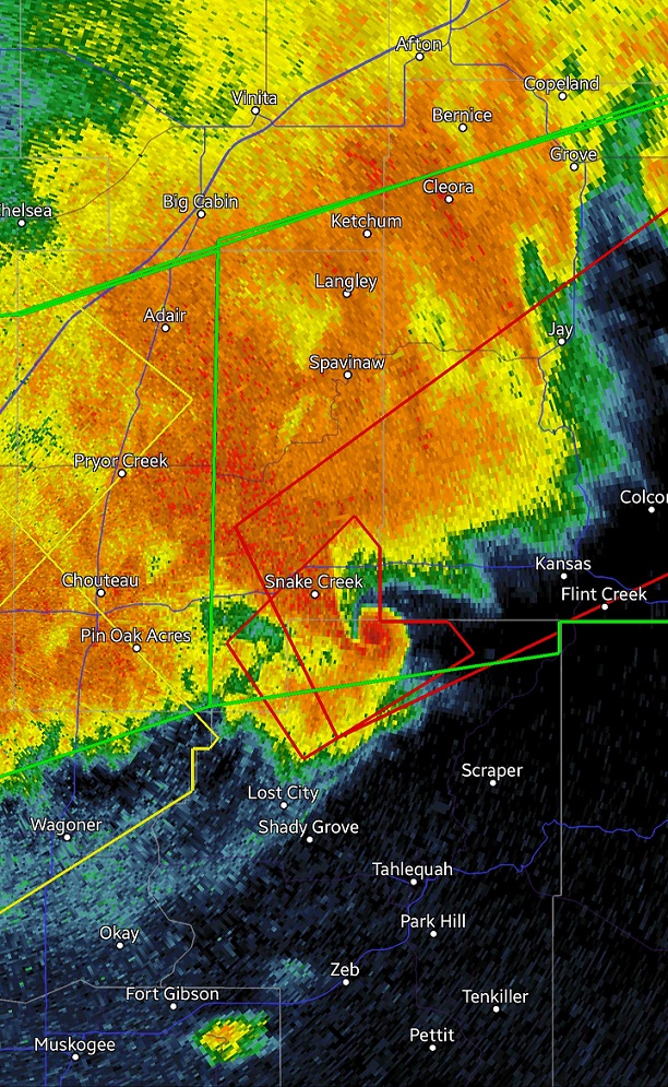
https://twitter.com/NWStulsa/status/1130681854309339136
https://twitter.com/NWStulsa/status/1130681854309339136
Tornado Warning
Severe Weather Statement
National Weather Service Tulsa OK
1049 PM CDT Mon May 20 2019
OKC021-041-210430-
/O.CON.KTSA.TO.W.0057.000000T0000Z-190521T0430Z/
Delaware OK-Cherokee OK-
1049 PM CDT Mon May 20 2019
...TORNADO EMERGENCY FOR LEACH...
...A TORNADO WARNING REMAINS IN EFFECT UNTIL 1130 PM CDT FOR SOUTHERN
DELAWARE AND NORTHEASTERN CHEROKEE COUNTIES...
At 1048 PM CDT, a confirmed large and destructive tornado was located
near Leach, moving northeast at 45 mph.
TORNADO EMERGENCY for Leach! This is a PARTICULARLY DANGEROUS
SITUATION. TAKE COVER NOW!
HAZARD...Deadly tornado.
SOURCE...Radar confirmed tornado.
IMPACT...You are in a life-threatening situation. Flying debris may
be deadly to those caught without shelter. Mobile homes
will be destroyed. Considerable damage to homes,
businesses, and vehicles is likely and complete destruction
is possible.
Locations in or near the path include...
Jay... Colcord...
Kansas... Oaks...
Leach... Twin Oaks...
Dodge... Lake Eucha State Park...
PRECAUTIONARY/PREPAREDNESS ACTIONS...
To repeat, a large, extremely dangerous, and potentially deadly
tornado is on the ground. To protect your life, TAKE COVER NOW! Move
to an interior room on the lowest floor of a sturdy building. Avoid
windows. If in a mobile home, a vehicle or outdoors, move to the
closest substantial shelter and protect yourself from flying debris.
1 likes
The above post and any post by Ntxw is NOT an official forecast and should not be used as such. It is just the opinion of the poster and may or may not be backed by sound meteorological data. It is NOT endorsed by any professional institution including Storm2k. For official information, please refer to NWS products.
Help support Storm2K!
-
cycloneye
- Admin
- Posts: 139234
- Age: 67
- Joined: Thu Oct 10, 2002 10:54 am
- Location: San Juan, Puerto Rico
Re: Severe Weather Outbreak in Southern Plains (May 20 thru May 21)
0 likes
Visit the Caribbean-Central America Weather Thread where you can find at first post web cams,radars
and observations from Caribbean basin members Click Here
and observations from Caribbean basin members Click Here
-
cycloneye
- Admin
- Posts: 139234
- Age: 67
- Joined: Thu Oct 10, 2002 10:54 am
- Location: San Juan, Puerto Rico
Re: Severe Weather Outbreak in Southern Plains (May 20 thru May 21)
Good news that only trees were afected by this tornado.
https://twitter.com/NWSNorman/status/1130852063984832512
https://twitter.com/NWSNorman/status/1130852063984832512
1 likes
Visit the Caribbean-Central America Weather Thread where you can find at first post web cams,radars
and observations from Caribbean basin members Click Here
and observations from Caribbean basin members Click Here
-
TheStormExpert

- Category 5

- Posts: 8487
- Age: 30
- Joined: Wed Feb 16, 2011 5:38 pm
- Location: Palm Beach Gardens, FL
Re: Severe Weather Outbreak in Southern Plains (May 20 thru May 21)
What happened with the tornado that hit Leach late last night?
0 likes
The following post is NOT an official forecast and should not be used as such. It is just the opinion of the poster and may or may not be backed by sound meteorological data. It is NOT endorsed by storm2k.org.
-
cycloneye
- Admin
- Posts: 139234
- Age: 67
- Joined: Thu Oct 10, 2002 10:54 am
- Location: San Juan, Puerto Rico
Re: Severe Weather Outbreak in Southern Plains (May 20 thru May 21)
0 likes
Visit the Caribbean-Central America Weather Thread where you can find at first post web cams,radars
and observations from Caribbean basin members Click Here
and observations from Caribbean basin members Click Here
-
HurricaneRyan
- Category 2

- Posts: 712
- Age: 30
- Joined: Sun Dec 05, 2010 3:05 pm
Re: Severe Weather Outbreak in Southern Plains (May 20 thru May 21)
The tornado in Mangum might have been EF4 or EF5 at some point in its life. The rating on that should be interesting
0 likes
Kay '22 Hilary '23
-
Tireman4

- S2K Supporter

- Posts: 5674
- Age: 58
- Joined: Fri Jun 30, 2006 1:08 pm
- Location: Humble, Texas
- Contact:
Re: Severe Weather Outbreak in Southern Plains (May 20 thru May 21)
he Storm Prediction Center has placed a POTENTIAL DANGEROUS SITUATION TORNADO WATCH for CENTRAL/SOUTHWESTERN OKLAHOMA .... This includes Oklahoma City Metro and nearby Wichita Falls Metro.
The NWS Storm Prediction Center has issued a
* Tornado Watch for portions of
Southwest and Central Oklahoma
Western North Texas
* Effective this Wednesday afternoon and evening from 230 PM
until 1000 PM CDT.
...THIS IS A PARTICULARLY DANGEROUS SITUATION...
* Primary threats include...
Several tornadoes and a few intense tornadoes likely
Scattered large hail likely with isolated very large hail events
to 3 inches in diameter possible
Scattered damaging wind gusts to 70 mph possible
SUMMARY...Isolated intense thunderstorms are expected to affect the
watch area this afternoon and early evening. Any storm that
persists will pose a risk of strong tornadoes, very large hail, and
damaging winds.
1 likes

Re: Severe Weather Outbreak in Southern Plains (May 20 thru May 21)
That PDS was out of nowhere 
1 likes
Return to “USA & Caribbean Weather”
Who is online
Users browsing this forum: ejburas and 54 guests