https://twitter.com/BenNollWeather/status/1133749838913392640
ENSO Updates (2007 thru 2023)
Moderator: S2k Moderators
Forum rules

The posts in this forum are NOT official forecasts and should not be used as such. They are just the opinion of the poster and may or may not be backed by sound meteorological data. They are NOT endorsed by any professional institution or STORM2K. For official information, please refer to products from the National Hurricane Center and National Weather Service.
-
SFLcane

- S2K Supporter

- Posts: 9606
- Age: 46
- Joined: Sat Jun 05, 2010 1:44 pm
- Location: Lake Worth Florida
Re: ENSO Updates
0 likes
-
Kingarabian

- S2K Supporter
- Posts: 15434
- Joined: Sat Aug 08, 2009 3:06 am
- Location: Honolulu, Hawaii
Re: ENSO Updates
GFS now takes the MJO into phase 2, similar to the Euro. Has a sizeable trade surge that extends to the dateline but keeps trades weak and relaxed over the EPAC for the forecast period:

CFS also takes the MJO into phase 2, similar to the Euro. Doesn't show much of an easterly component in its forecasts, keeps trades or westerlies blowing over the dateline, but has a strong trade burst over the EPAC:

So if the GFS solution materializes, a weak traditional El Nino will likely persist due to the trades blowing over an area that has sufficient warmth while weaker trades don't encourage much cooling over the EPAC.
If the CFS solution materializes the weak traditional El Nino signature over the Pacific ocean will surely disappear and a Modoki-esque signature will take over.
CFS also takes the MJO into phase 2, similar to the Euro. Doesn't show much of an easterly component in its forecasts, keeps trades or westerlies blowing over the dateline, but has a strong trade burst over the EPAC:
So if the GFS solution materializes, a weak traditional El Nino will likely persist due to the trades blowing over an area that has sufficient warmth while weaker trades don't encourage much cooling over the EPAC.
If the CFS solution materializes the weak traditional El Nino signature over the Pacific ocean will surely disappear and a Modoki-esque signature will take over.
2 likes
RIP Kobe Bryant
-
NotSparta

- Professional-Met

- Posts: 1647
- Age: 22
- Joined: Fri Aug 18, 2017 8:24 am
- Location: Naples, FL
- Contact:
Re: ENSO Updates
Kingarabian wrote:GFS now takes the MJO into phase 2, similar to the Euro. Has a sizeable trade surge that extends to the dateline but keeps trades weak and relaxed over the EPAC for the forecast period:
https://i.imgur.com/FniTWBW.png
CFS also takes the MJO into phase 2, similar to the Euro. Doesn't show much of an easterly component in its forecasts, keeps trades or westerlies blowing over the dateline, but has a strong trade burst over the EPAC:
https://i.imgur.com/UplNhlo.png
So if the GFS solution materializes, a weak traditional El Nino will likely persist due to the trades blowing over an area that has sufficient warmth while weaker trades don't encourage much cooling over the EPAC.
If the CFS solution materializes the weak traditional El Nino signature over the Pacific ocean will surely disappear and a Modoki-esque signature will take over.
I think the GFS solution is more damaging to El Niño. A dateline EWB is something you see in cool ENSO, and would excite another upwelling KW (possibly). The near normal trades further east would keep the area from being too cool but the KW lurking below would still keep SSTs down.
I agree w/ your second point, the EPAC would get quite cold but would be more favorable for warm ENSO in the long run
0 likes
This post was probably an opinion of mine, and in no way is official. Please refer to http://www.hurricanes.gov for official tropical analysis and advisories.
My website, with lots of tropical wx graphics, including satellite and recon: http://cyclonicwx.com
My website, with lots of tropical wx graphics, including satellite and recon: http://cyclonicwx.com
-
Kingarabian
- S2K Supporter
- Posts: 15434
- Joined: Sat Aug 08, 2009 3:06 am
- Location: Honolulu, Hawaii
Re: ENSO Updates
NotSparta wrote:Kingarabian wrote:GFS now takes the MJO into phase 2, similar to the Euro. Has a sizeable trade surge that extends to the dateline but keeps trades weak and relaxed over the EPAC for the forecast period:
https://i.imgur.com/FniTWBW.png
CFS also takes the MJO into phase 2, similar to the Euro. Doesn't show much of an easterly component in its forecasts, keeps trades or westerlies blowing over the dateline, but has a strong trade burst over the EPAC:
https://i.imgur.com/UplNhlo.png
So if the GFS solution materializes, a weak traditional El Nino will likely persist due to the trades blowing over an area that has sufficient warmth while weaker trades don't encourage much cooling over the EPAC.
If the CFS solution materializes the weak traditional El Nino signature over the Pacific ocean will surely disappear and a Modoki-esque signature will take over.
I think the GFS solution is more damaging to El Niño. A dateline EWB is something you see in cool ENSO, and would excite another upwelling KW (possibly). The near normal trades further east would keep the area from being too cool but the KW lurking below would still keep SSTs down.
I agree w/ your second point, the EPAC would get quite cold but would be more favorable for warm ENSO in the long run
One of the reasons why I don't think the GFS solution will be as damaging is due to the deep warm +1C/+1.5C anomalies beneath Nino 4 and Nino 3.4. Also both 2016 and 2017 had similar trade burst setups only for cooling to be very slow to occur.
If it gets to the CPAC with stronger easterlies than currently forecast it would be quite damaging.
1 likes
RIP Kobe Bryant
-
NotSparta
- Professional-Met
- Posts: 1647
- Age: 22
- Joined: Fri Aug 18, 2017 8:24 am
- Location: Naples, FL
- Contact:
Re: ENSO Updates
Kingarabian wrote:NotSparta wrote:Kingarabian wrote:GFS now takes the MJO into phase 2, similar to the Euro. Has a sizeable trade surge that extends to the dateline but keeps trades weak and relaxed over the EPAC for the forecast period:
https://i.imgur.com/FniTWBW.png
CFS also takes the MJO into phase 2, similar to the Euro. Doesn't show much of an easterly component in its forecasts, keeps trades or westerlies blowing over the dateline, but has a strong trade burst over the EPAC:
https://i.imgur.com/UplNhlo.png
So if the GFS solution materializes, a weak traditional El Nino will likely persist due to the trades blowing over an area that has sufficient warmth while weaker trades don't encourage much cooling over the EPAC.
If the CFS solution materializes the weak traditional El Nino signature over the Pacific ocean will surely disappear and a Modoki-esque signature will take over.
I think the GFS solution is more damaging to El Niño. A dateline EWB is something you see in cool ENSO, and would excite another upwelling KW (possibly). The near normal trades further east would keep the area from being too cool but the KW lurking below would still keep SSTs down.
I agree w/ your second point, the EPAC would get quite cold but would be more favorable for warm ENSO in the long run
One of the reasons why I don't think the GFS solution will be as damaging is due to the deep warm +1C/+1.5C anomalies beneath Nino 4 and Nino 3.4. Also both 2016 and 2017 had similar trade burst setups only for cooling to be very slow to occur.
If it gets to the CPAC with stronger easterlies than currently forecast it would be quite damaging.
True, might be moreso if it were shifted east. But the easterlies over the warm anomalies would help pretty much erase them, so then there would be absolutely no fuel left
0 likes
This post was probably an opinion of mine, and in no way is official. Please refer to http://www.hurricanes.gov for official tropical analysis and advisories.
My website, with lots of tropical wx graphics, including satellite and recon: http://cyclonicwx.com
My website, with lots of tropical wx graphics, including satellite and recon: http://cyclonicwx.com
-
Kingarabian
- S2K Supporter
- Posts: 15434
- Joined: Sat Aug 08, 2009 3:06 am
- Location: Honolulu, Hawaii
Re: ENSO Updates
NotSparta wrote:Kingarabian wrote:NotSparta wrote:
I think the GFS solution is more damaging to El Niño. A dateline EWB is something you see in cool ENSO, and would excite another upwelling KW (possibly). The near normal trades further east would keep the area from being too cool but the KW lurking below would still keep SSTs down.
I agree w/ your second point, the EPAC would get quite cold but would be more favorable for warm ENSO in the long run
One of the reasons why I don't think the GFS solution will be as damaging is due to the deep warm +1C/+1.5C anomalies beneath Nino 4 and Nino 3.4. Also both 2016 and 2017 had similar trade burst setups only for cooling to be very slow to occur.
If it gets to the CPAC with stronger easterlies than currently forecast it would be quite damaging.
True, might be moreso if it were shifted east. But the easterlies over the warm anomalies would help pretty much erase them, so then there would be absolutely no fuel left
It's very possible the thermocline rises in that region and we see those warm anomalies disappear, but if we're continuing the same MJO setup since late April and through most of May, another WWB will be in the works and also will likely rewarm the Nino regions. To break this pattern we need the MJO to amplify over the MC and trigger another trade burst vs. having the MJO end up back over the Pacific ocean.
1 likes
RIP Kobe Bryant
-
NotSparta
- Professional-Met
- Posts: 1647
- Age: 22
- Joined: Fri Aug 18, 2017 8:24 am
- Location: Naples, FL
- Contact:
Re: ENSO Updates
Kingarabian wrote:NotSparta wrote:Kingarabian wrote:
One of the reasons why I don't think the GFS solution will be as damaging is due to the deep warm +1C/+1.5C anomalies beneath Nino 4 and Nino 3.4. Also both 2016 and 2017 had similar trade burst setups only for cooling to be very slow to occur.
If it gets to the CPAC with stronger easterlies than currently forecast it would be quite damaging.
True, might be moreso if it were shifted east. But the easterlies over the warm anomalies would help pretty much erase them, so then there would be absolutely no fuel left
It's very possible the thermocline rises in that region and we see those warm anomalies disappear, but if we're continuing the same MJO setup since late April and through most of May, another WWB will be in the works and also will likely rewarm the Nino regions. To break this pattern we need the MJO to amplify over the MC and trigger another trade burst vs. having the MJO end up back over the Pacific ocean.
It would be consistent w/ the recent pattern. Despite the WWBs the upper ocean anomalies have fallen 1.5°C. The EWBs have had a bigger effect lately.
Anyway, that's exactly what the GFS does. It has rising air setting up over the MC region w/ dateline sinking. That's a -ENSO pattern, which is why the GFS shows a trade burst. Also, it's proof that this event is weakening. This MJO pulse was strong, which helped it, but still, the standing wave was steamrolled unusually easily, & this upcoming -ENSO pattern which the GFS predicts starts the EWB is unusually sticky unless it suddenly changes after the fcst period
1 likes
This post was probably an opinion of mine, and in no way is official. Please refer to http://www.hurricanes.gov for official tropical analysis and advisories.
My website, with lots of tropical wx graphics, including satellite and recon: http://cyclonicwx.com
My website, with lots of tropical wx graphics, including satellite and recon: http://cyclonicwx.com
-
Kingarabian
- S2K Supporter
- Posts: 15434
- Joined: Sat Aug 08, 2009 3:06 am
- Location: Honolulu, Hawaii
Re: ENSO Updates
NotSparta wrote:Kingarabian wrote:NotSparta wrote:
True, might be moreso if it were shifted east. But the easterlies over the warm anomalies would help pretty much erase them, so then there would be absolutely no fuel left
It's very possible the thermocline rises in that region and we see those warm anomalies disappear, but if we're continuing the same MJO setup since late April and through most of May, another WWB will be in the works and also will likely rewarm the Nino regions. To break this pattern we need the MJO to amplify over the MC and trigger another trade burst vs. having the MJO end up back over the Pacific ocean.
It would be consistent w/ the recent pattern. Despite the WWBs the upper ocean anomalies have fallen 1.5°C. The EWBs have had a bigger effect lately.
Anyway, that's exactly what the GFS does. It has rising air setting up over the MC region w/ dateline sinking. That's a -ENSO pattern, which is why the GFS shows a trade burst. Also, it's proof that this event is weakening. This MJO pulse was strong, which helped it, but still, the standing wave was steamrolled unusually easily, & this upcoming -ENSO pattern which the GFS predicts starts the EWB is unusually sticky unless it suddenly changes after the fcst period
[url]https://uploads.disquscdn.com/images/9c22fca9f8f18dedd4079983fa91e57c8c66760384a38bbbf7d53044679158b1.gif[url]
Don't forget that this is rather a weak event and the standing wave will likely pulsate on and off.
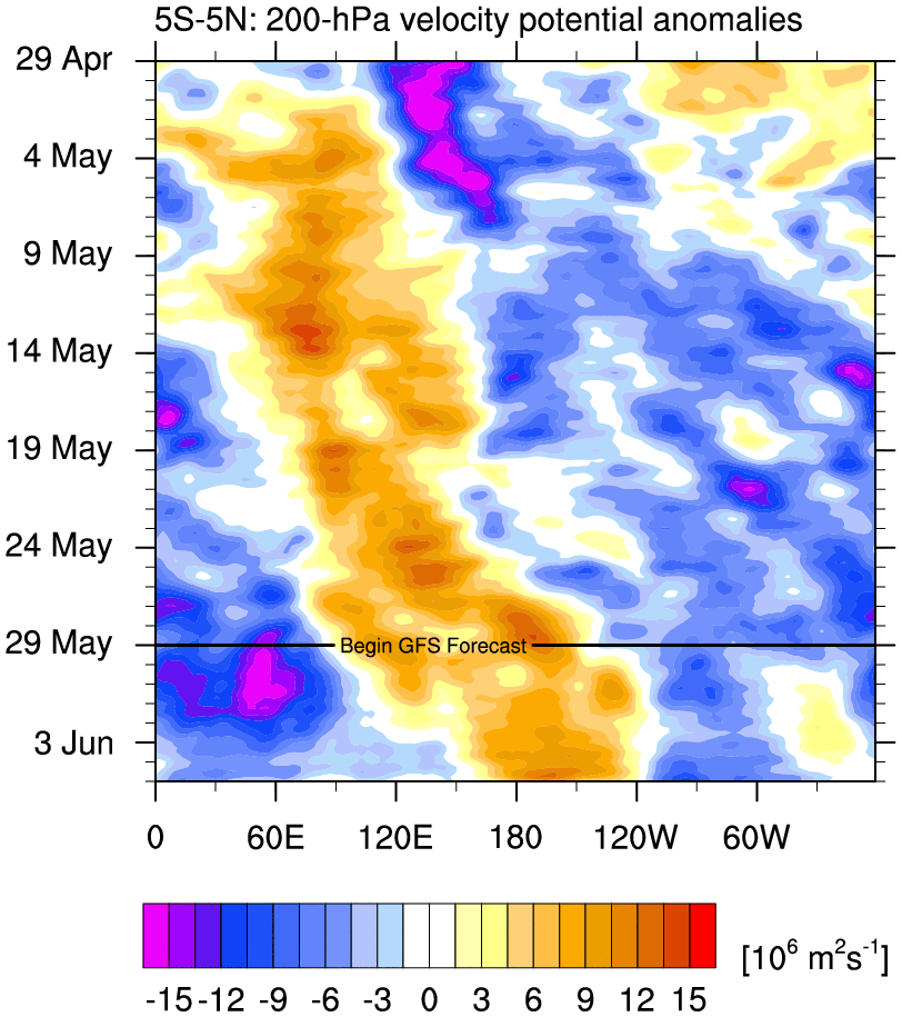
I see this EWB triggered due to the MJO amplifying over the IO (60E). On this graphic, it shows It has rising motion concentrated over 90% of the IO with a slight amount over the MC, with -VP200 anomalies later spreading into the WPAC due to MJO progression.
CFS's forecasts go further out, and show the same although a weaker pulse over the IO, disrupts the present standing wave then has -VP200 anomalies returning over the CPAC:

Also the CFS continue to showsa classic El Nino atmosphere with rising air situated more east.

4 likes
RIP Kobe Bryant
-
cycloneye

- Admin

- Posts: 139065
- Age: 67
- Joined: Thu Oct 10, 2002 10:54 am
- Location: San Juan, Puerto Rico
Re: ENSO Updates
4 likes
Visit the Caribbean-Central America Weather Thread where you can find at first post web cams,radars
and observations from Caribbean basin members Click Here
and observations from Caribbean basin members Click Here


-
Shell Mound
- Category 5

- Posts: 2434
- Age: 31
- Joined: Thu Sep 07, 2017 3:39 pm
- Location: St. Petersburg, FL → Scandinavia
Re: ENSO Updates
https://twitter.com/cyclonicwx/status/1134138030955094018
https://twitter.com/cyclonicwx/status/1134138735291961344
https://twitter.com/cyclonicwx/status/1134143708931264512
https://twitter.com/cyclonicwx/status/1134155477410025472
https://twitter.com/akshaysampathk1/status/1134330876668465152
https://twitter.com/cyclonicwx/status/1134138735291961344
https://twitter.com/cyclonicwx/status/1134143708931264512
https://twitter.com/cyclonicwx/status/1134155477410025472
https://twitter.com/akshaysampathk1/status/1134330876668465152
2 likes
CVW / MiamiensisWx / Shell Mound
The posts in this forum are NOT official forecasts and should not be used as such. They are just the opinion of the poster and may or may not be backed by sound meteorological data. They are NOT endorsed by any professional institution or STORM2K. For official information, please refer to products from the NHC and NWS.
-
NotSparta
- Professional-Met
- Posts: 1647
- Age: 22
- Joined: Fri Aug 18, 2017 8:24 am
- Location: Naples, FL
- Contact:
Re: ENSO Updates
Yeah it's not so clear yet but the warmest scenario so far looks like maintenance. More likely, however, there is some cooling going on there esp w/ interference from Africa & EHem monsoons beginning
2 likes
This post was probably an opinion of mine, and in no way is official. Please refer to http://www.hurricanes.gov for official tropical analysis and advisories.
My website, with lots of tropical wx graphics, including satellite and recon: http://cyclonicwx.com
My website, with lots of tropical wx graphics, including satellite and recon: http://cyclonicwx.com

Re: ENSO Updates
I mentioned this to the pros on twitter that even though the latest Euro is still showing El Nino to continue through Fall the trend from its ensembles is that more of them are going to the warm neutral to weak El Nino category and lets not forget how warm biased the Euro is when it come to forecasting ENSO conditions this time of the year.


1 likes

Re: ENSO Updates
The next few months through early fall will be defined as weak modoki El Nino. ONI will hold >0.5C at least for two more trimonthlies. Daily SOI leans more negative towards El Nino but that has some noise, also some lag effect. The longer term SOI are tilted negative, which is indicative of weak Nino.
A good bet is for persistence the next few months then gradually ease into neutral.
The US, jolted a lot by the plains and California has experienced the wettest 12 month period on record.
https://visibleearth.nasa.gov/view.php?id=145101
A good bet is for persistence the next few months then gradually ease into neutral.
The US, jolted a lot by the plains and California has experienced the wettest 12 month period on record.
The continental United States recently finished its soggiest 12 months in 124 years of modern recordkeeping. The results are visible in satellite measurements of fresh water.
From May 1, 2018, to April 30, 2019, the lower 48 states collectively averaged 36.20 inches (919.48 millimeters) of precipitation, a full 6.25 inches (158.75 mm) above the mean. The previous record (April 2015 to March 2016) was 35.95 inches. According to the National Centers for Environmental Information, ten U.S. states had their wettest 12 months, and three others were in the top three. Many of them were clustered in the Mid-Atlantic and Midwest regions.
According to the May 21 report from the U.S. Drought Monitor, just 2.72 percent of the contiguous U.S. was in drought, among the lowest levels in two decades of records. California is completely out of drought for the first time since 2011. As recently as February 2018, one-third of the United States was in drought.
https://visibleearth.nasa.gov/view.php?id=145101
5 likes
The above post and any post by Ntxw is NOT an official forecast and should not be used as such. It is just the opinion of the poster and may or may not be backed by sound meteorological data. It is NOT endorsed by any professional institution including Storm2k. For official information, please refer to NWS products.
Help support Storm2K!
-
SFLcane
- S2K Supporter
- Posts: 9606
- Age: 46
- Joined: Sat Jun 05, 2010 1:44 pm
- Location: Lake Worth Florida
Re: ENSO Updates
NDG wrote:I mentioned this to the pros on twitter that even though the latest Euro is still showing El Nino to continue through Fall the trend from its ensembles is that more of them are going to the warm neutral to weak El Nino category and lets not forget how warm biased the Euro is when it come to forecasting ENSO conditions this time of the year.
https://i.imgur.com/yTZhQWN.jpg
https://i.imgur.com/Odczbn9.jpg
https://i.imgur.com/fsaYei3.jpg
Yes we'll have to see what the June forecast is
0 likes
-
Kingarabian
- S2K Supporter
- Posts: 15434
- Joined: Sat Aug 08, 2009 3:06 am
- Location: Honolulu, Hawaii
Re: ENSO Updates
Ntxw wrote:The next few months through early fall will be defined as weak modoki El Nino. ONI will hold >0.5C at least for two more trimonthlies. Daily SOI leans more negative towards El Nino but that has some noise, also some lag effect. The longer term SOI are tilted negative, which is indicative of weak Nino.
A good bet is for persistence the next few months then gradually ease into neutral.
[url]https://images2.imgbox.com/d9/30/iF8nMiXd_o.gif[url]
The US, jolted a lot by the plains and California has experienced the wettest 12 month period on record.The continental United States recently finished its soggiest 12 months in 124 years of modern recordkeeping. The results are visible in satellite measurements of fresh water.
From May 1, 2018, to April 30, 2019, the lower 48 states collectively averaged 36.20 inches (919.48 millimeters) of precipitation, a full 6.25 inches (158.75 mm) above the mean. The previous record (April 2015 to March 2016) was 35.95 inches. According to the National Centers for Environmental Information, ten U.S. states had their wettest 12 months, and three others were in the top three. Many of them were clustered in the Mid-Atlantic and Midwest regions.
According to the May 21 report from the U.S. Drought Monitor, just 2.72 percent of the contiguous U.S. was in drought, among the lowest levels in two decades of records. California is completely out of drought for the first time since 2011. As recently as February 2018, one-third of the United States was in drought.
https://visibleearth.nasa.gov/view.php?id=145101
Agreed.
I would say 50/50 chance of ENSO going into neutral or remaining in weak El Nino by fall. Good chance we go into neutral if this upcoming trade surge does the job. If it fails to cool the subsurface significantly and a WWB follows it, there's a good chance we remain in weak El Nino past the fall. I think at this point in time both options are on the table.
3 likes
RIP Kobe Bryant
-
NotSparta
- Professional-Met
- Posts: 1647
- Age: 22
- Joined: Fri Aug 18, 2017 8:24 am
- Location: Naples, FL
- Contact:
Re: ENSO Updates
Kingarabian wrote:Ntxw wrote:The next few months through early fall will be defined as weak modoki El Nino. ONI will hold >0.5C at least for two more trimonthlies. Daily SOI leans more negative towards El Nino but that has some noise, also some lag effect. The longer term SOI are tilted negative, which is indicative of weak Nino.
A good bet is for persistence the next few months then gradually ease into neutral.
[url]https://images2.imgbox.com/d9/30/iF8nMiXd_o.gif[url]
The US, jolted a lot by the plains and California has experienced the wettest 12 month period on record.The continental United States recently finished its soggiest 12 months in 124 years of modern recordkeeping. The results are visible in satellite measurements of fresh water.
From May 1, 2018, to April 30, 2019, the lower 48 states collectively averaged 36.20 inches (919.48 millimeters) of precipitation, a full 6.25 inches (158.75 mm) above the mean. The previous record (April 2015 to March 2016) was 35.95 inches. According to the National Centers for Environmental Information, ten U.S. states had their wettest 12 months, and three others were in the top three. Many of them were clustered in the Mid-Atlantic and Midwest regions.
According to the May 21 report from the U.S. Drought Monitor, just 2.72 percent of the contiguous U.S. was in drought, among the lowest levels in two decades of records. California is completely out of drought for the first time since 2011. As recently as February 2018, one-third of the United States was in drought.
https://visibleearth.nasa.gov/view.php?id=145101
Agreed.
I would say 50/50 chance of ENSO going into neutral or remaining in weak El Nino by fall. Good chance we go into neutral if this upcoming trade surge does the job. If it fails to cool the subsurface significantly and a WWB follows it, there's a good chance we remain in weak El Nino past the fall. I think at this point in time both options are on the table.
Agree, but leaning a bit towards the former. The EWB trended stronger, especially east of the dateline. Would help the upwelling KW surface & arrest the downwelling KW. Really depends what the EWB does though
0 likes
This post was probably an opinion of mine, and in no way is official. Please refer to http://www.hurricanes.gov for official tropical analysis and advisories.
My website, with lots of tropical wx graphics, including satellite and recon: http://cyclonicwx.com
My website, with lots of tropical wx graphics, including satellite and recon: http://cyclonicwx.com
-
Kingarabian
- S2K Supporter
- Posts: 15434
- Joined: Sat Aug 08, 2009 3:06 am
- Location: Honolulu, Hawaii
Re: ENSO Updates
NotSparta wrote:Kingarabian wrote:Ntxw wrote:The next few months through early fall will be defined as weak modoki El Nino. ONI will hold >0.5C at least for two more trimonthlies. Daily SOI leans more negative towards El Nino but that has some noise, also some lag effect. The longer term SOI are tilted negative, which is indicative of weak Nino.
A good bet is for persistence the next few months then gradually ease into neutral.
[url]https://images2.imgbox.com/d9/30/iF8nMiXd_o.gif[url]
The US, jolted a lot by the plains and California has experienced the wettest 12 month period on record.
https://visibleearth.nasa.gov/view.php?id=145101
Agreed.
I would say 50/50 chance of ENSO going into neutral or remaining in weak El Nino by fall. Good chance we go into neutral if this upcoming trade surge does the job. If it fails to cool the subsurface significantly and a WWB follows it, there's a good chance we remain in weak El Nino past the fall. I think at this point in time both options are on the table.
Agree, but leaning a bit towards the former. The EWB trended stronger, especially east of the dateline. Would help the upwelling KW surface & arrest the downwelling KW. Really depends what the EWB does though
[url]https://uploads.disquscdn.com/images/6760db30dff2a263141991d12cc267de2006837186257237ab2dfacc4d13ee0b.gif[url]
GFS trending stronger due to increased amplification over phase 3 while the Euro and CFS flatline and go into the circle after phase 2. It'll come down to if the models push the MJO back over the Pacific or not, which we won't know until about another 2 weeks.
2 likes
RIP Kobe Bryant
-
Kingarabian
- S2K Supporter
- Posts: 15434
- Joined: Sat Aug 08, 2009 3:06 am
- Location: Honolulu, Hawaii
Re: ENSO Updates
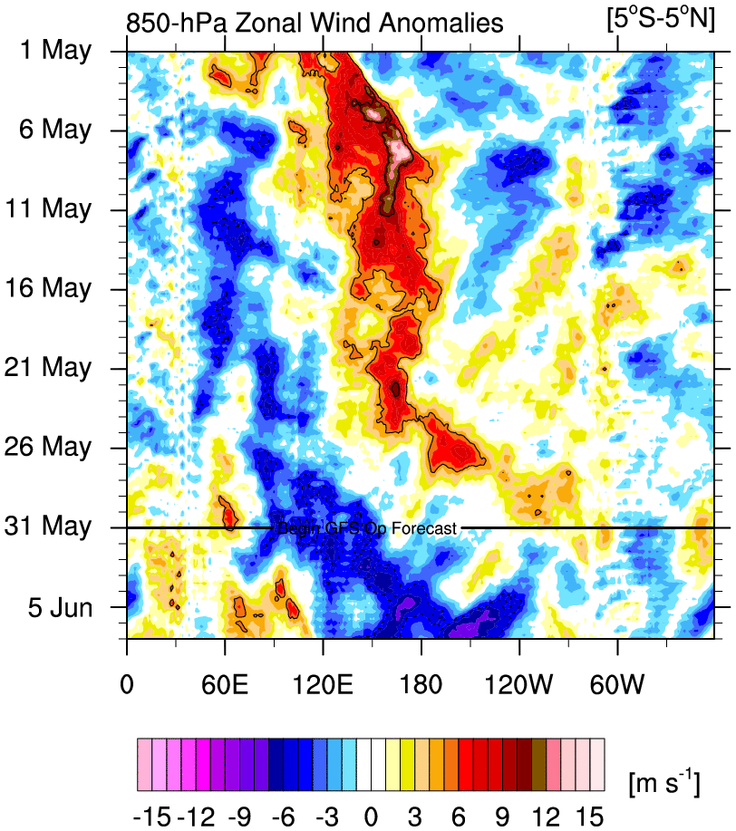
This 90 day hovmoller nicely illustrates the pattern we've been in since January:

So it's not out of the realm to assume that there is potential for a WWB to follow this trade surge.
So it's not out of the realm to assume that there is potential for a WWB to follow this trade surge.
1 likes
RIP Kobe Bryant
Who is online
Users browsing this forum: pavelbure224 and 227 guests