ENSO Updates (2007 thru 2023)
Moderator: S2k Moderators
Forum rules

The posts in this forum are NOT official forecasts and should not be used as such. They are just the opinion of the poster and may or may not be backed by sound meteorological data. They are NOT endorsed by any professional institution or STORM2K. For official information, please refer to products from the National Hurricane Center and National Weather Service.
-
CyclonicFury

- Category 5

- Posts: 1974
- Age: 25
- Joined: Sun Jul 02, 2017 12:32 pm
- Location: NC
- Contact:
Re: ENSO Updates
The July CanSIPS came in considerably cooler and now shows a transition to warm-neutral ENSO this summer, before appearing to show a new east-based weak El Nino event forming this winter.
8 likes
NCSU B.S. in Meteorology Class of 2021. Tropical weather blogger at http://www.cyclonicfury.com. My forecasts and thoughts are NOT official, for official forecasts please consult the National Hurricane Center.
-
cycloneye

- Admin

- Posts: 139056
- Age: 67
- Joined: Thu Oct 10, 2002 10:54 am
- Location: San Juan, Puerto Rico
Re: ENSO Updates
2 likes
Visit the Caribbean-Central America Weather Thread where you can find at first post web cams,radars
and observations from Caribbean basin members Click Here
and observations from Caribbean basin members Click Here


-
Kingarabian

- S2K Supporter

- Posts: 15434
- Joined: Sat Aug 08, 2009 3:06 am
- Location: Honolulu, Hawaii
Re: ENSO: CPC Weekly update: Niño 3.4 down to +0.3C
Very robust upwelling Kelvin wave showing up on those PENTAD graphics. No doubt about that. But to also have a standing El Nino wave in the EPAC developing at the same is head scratching.
https://twitter.com/MJVentrice/status/1145713358999621632
https://twitter.com/MJVentrice/status/1145713358999621632
2 likes
RIP Kobe Bryant
-
Kingarabian
- S2K Supporter
- Posts: 15434
- Joined: Sat Aug 08, 2009 3:06 am
- Location: Honolulu, Hawaii
Re: ENSO Updates
Kingarabian wrote:Here's the pressure forecast for Tahiti and Darwin (note these are rounded estimates). It's derived from today's 12z Euro:
Tahiti:Code: Select all
June 30:1014.75
July 1:1016.00
July 2:1016.50
July 3:1016.00
July 4:1016.00
July 5:1016.00
July 6:1015.00
July 7:1014.00
July 8:1014.00
Darwin:Code: Select all
June 30:1013.50
July 1:1014.00
July 2:1014.00
July 3:1015.00
July 4:1015.50
July 5:1015.00
July 6:1015.50
July 7:1016.00
July 8:1015.50
IF this forecast holds true, we should see the SOI turn positive from June30-July3 before crashing again.
I give up. Euro continues to do poorly and forecasting correct pressures over Tahiti. Pressures continue to come in lower than modeled.
3 likes
RIP Kobe Bryant

Re: ENSO Updates
Kingarabian wrote:Kingarabian wrote:Here's the pressure forecast for Tahiti and Darwin (note these are rounded estimates). It's derived from today's 12z Euro:
Tahiti:Code: Select all
June 30:1014.75
July 1:1016.00
July 2:1016.50
July 3:1016.00
July 4:1016.00
July 5:1016.00
July 6:1015.00
July 7:1014.00
July 8:1014.00
Darwin:Code: Select all
June 30:1013.50
July 1:1014.00
July 2:1014.00
July 3:1015.00
July 4:1015.50
July 5:1015.00
July 6:1015.50
July 7:1016.00
July 8:1015.50
IF this forecast holds true, we should see the SOI turn positive from June30-July3 before crashing again.
I give up. Euro continues to do poorly and forecasting correct pressures over Tahiti. Pressures continue to come in lower than modeled.
The cold waters over the MC (Darwin included) is also a consistent influence causing this. This region is a key player in the equatorial tropics as well. So while the Pacific has cooled, the MC has not warmed (important for Nina) to provide convection away from the Pacific.
3 likes
The above post and any post by Ntxw is NOT an official forecast and should not be used as such. It is just the opinion of the poster and may or may not be backed by sound meteorological data. It is NOT endorsed by any professional institution including Storm2k. For official information, please refer to NWS products.
Help support Storm2K!
-
NotSparta

- Professional-Met

- Posts: 1647
- Age: 22
- Joined: Fri Aug 18, 2017 8:24 am
- Location: Naples, FL
- Contact:
Re: ENSO: CPC Weekly update: Niño 3.4 down to +0.3C
Kingarabian wrote:Very robust upwelling Kelvin wave showing up on those PENTAD graphics. No doubt about that. But to also have a standing El Nino wave in the EPAC developing at the same is head scratching.
https://twitter.com/MJVentrice/status/1145713358999621632
Definitely appears influenced by the +PMM. If that'll help the Niño, that I'm less sure of
0 likes
This post was probably an opinion of mine, and in no way is official. Please refer to http://www.hurricanes.gov for official tropical analysis and advisories.
My website, with lots of tropical wx graphics, including satellite and recon: http://cyclonicwx.com
My website, with lots of tropical wx graphics, including satellite and recon: http://cyclonicwx.com
-
floridasun78
- Category 5
- Posts: 3755
- Joined: Sun May 17, 2009 10:16 pm
- Location: miami fl
Re: ENSO: CPC Weekly update: Niño 3.4 down to +0.3C
so atl ocean side may pick up with kvein wave moving east? weaker elnino
0 likes
-
Kingarabian
- S2K Supporter
- Posts: 15434
- Joined: Sat Aug 08, 2009 3:06 am
- Location: Honolulu, Hawaii
Re: ENSO Updates
Ntxw wrote:The cold waters over the MC (Darwin included) is also a consistent influence causing this. This region is a key player in the equatorial tropics as well. So while the Pacific has cooled, the MC has not warmed (important for Nina) to provide convection away from the Pacific.
And I believe that's causing tilt in the pressure pattern with at least some correlation with SOI continuing to be more negative than modeled, forcing the GFS to to adjust and show a prolonged reduced trade event.
EPS also has something similar:
https://twitter.com/webberweather/status/1145693755967717376
So by theory, this would give the Nino regions relief from cooling. But for how long? We'll see.
4 likes
RIP Kobe Bryant
Re: ENSO: CPC Weekly update: Niño 3.4 down to +0.3C
This is the reasoning to hold steady and not let day to day and even week to week changes get excited one way or the other. When there is conflicting signals it tends to balance each other out. Just as cooling dominated the past few weeks, it may switch to warming for a few weeks.

7 likes
The above post and any post by Ntxw is NOT an official forecast and should not be used as such. It is just the opinion of the poster and may or may not be backed by sound meteorological data. It is NOT endorsed by any professional institution including Storm2k. For official information, please refer to NWS products.
Help support Storm2K!
Help support Storm2K!
-
Kingarabian
- S2K Supporter
- Posts: 15434
- Joined: Sat Aug 08, 2009 3:06 am
- Location: Honolulu, Hawaii
Re: ENSO Updates
SOI finally switched positive. Let's see how long it lasts.
4 likes
RIP Kobe Bryant
-
Kingarabian
- S2K Supporter
- Posts: 15434
- Joined: Sat Aug 08, 2009 3:06 am
- Location: Honolulu, Hawaii
Re: ENSO Updates
I don't think there will be Nino associated shear over the Caribbean nor the MDR through ASO. But because there is a Nino standing wave which is likely associated with a rising air branch of the Walker cell -- if it persists, there's a chance for all the rising air over the EPAC to sink back down somewhere over the Atlantic.
https://twitter.com/BenNollWeather/status/1146058695329099776
https://twitter.com/BenNollWeather/status/1146058695329099776
3 likes
RIP Kobe Bryant
-
SFLcane

- S2K Supporter
- Posts: 9606
- Age: 46
- Joined: Sat Jun 05, 2010 1:44 pm
- Location: Lake Worth Florida
Re: ENSO: CPC Weekly update: Niño 3.4 down to +0.3C
Ntxw wrote:This is the reasoning to hold steady and not let day to day and even week to week changes get excited one way or the other. When there is conflicting signals it tends to balance each other out. Just as cooling dominated the past few weeks, it may switch to warming for a few weeks.
https://images2.imgbox.com/07/7f/Ph7k0nWA_o.gif
El Niño could rebound but the subsurface is quite cool still.
0 likes
Re: ENSO Updates
ONI for AMJ came in at +0.7C which means there is/was still El Nino (weak and modoki). If cooling in theory were to continue MJJ may not make it to neutral but JJA could in the September update.
1 likes
The above post and any post by Ntxw is NOT an official forecast and should not be used as such. It is just the opinion of the poster and may or may not be backed by sound meteorological data. It is NOT endorsed by any professional institution including Storm2k. For official information, please refer to NWS products.
Help support Storm2K!
Help support Storm2K!

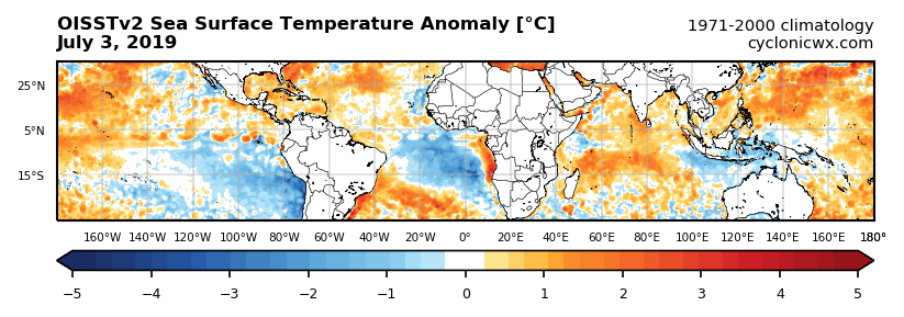
Re: ENSO Updates
Kingarabian wrote:SOI finally switched positive. Let's see how long it lasts.
Not very long if you're looking for continuous +SOI. Darwin's pressures remain high. The walker circulation is farther to the east than cold neutral or Nina due to the cold MC.
This is strictly a Central Pacific squeezed modoki now. Image below courtesy of Notsparta's site, very good if you want a clean look from OISSTv2.
5 likes
The above post and any post by Ntxw is NOT an official forecast and should not be used as such. It is just the opinion of the poster and may or may not be backed by sound meteorological data. It is NOT endorsed by any professional institution including Storm2k. For official information, please refer to NWS products.
Help support Storm2K!
Help support Storm2K!
-
weathaguyry

- Category 5
- Posts: 1272
- Age: 20
- Joined: Wed Jun 15, 2016 5:16 am
- Location: Long Island, NY
Re: ENSO Updates
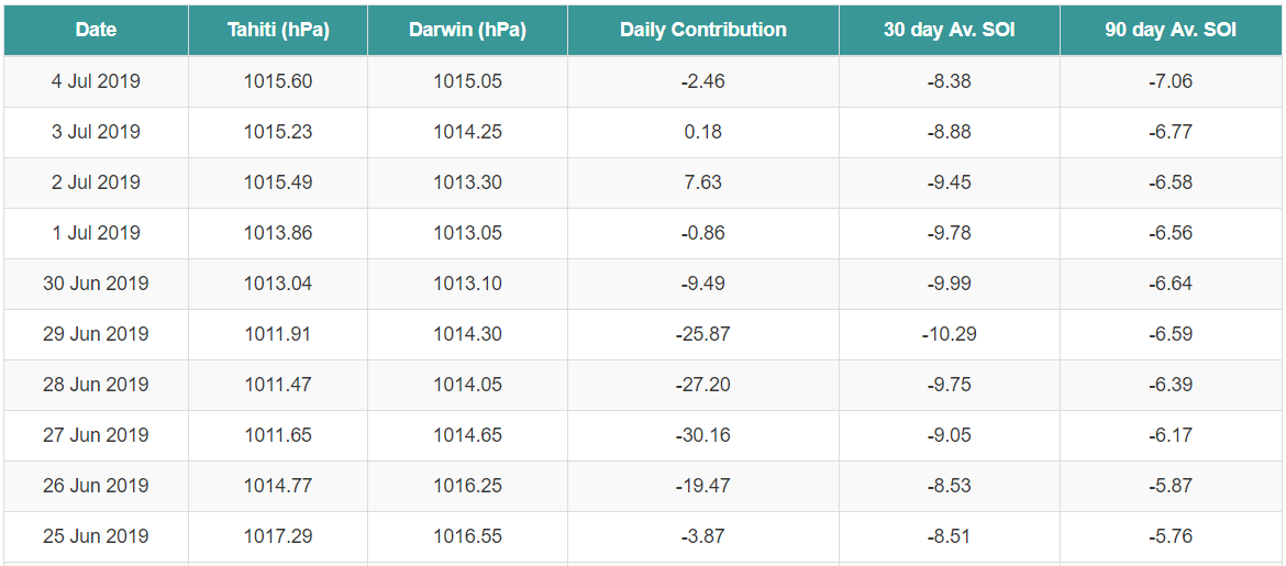
Here's how the Euro pressure forecast from 12z 6/29 held up...
(The left is the forecasted value, the right is the observation)
Tahiti
6/30:1014.75/1013.04
7/1:1016.0/1013.86
7/2:1016.5/1015.49
7/3:1016.0/1015.23
7/4:1016.0/1015.60
Darwin
6/30:1013.5/1013.10
7/1:1014.0/1013.05
7/2:1014.0/1013.30
7/3:1015.0/1014.25
7/4:1015.5/1015.05
Based on the forecast, the SOI should've been decently positive from 6/30-7/3, however the SOI only went positive on 7/2 (7.63), and barely on 7/3 (0.18). It's frustrating that the forecasts are not verifying, because the SOI is one of the only indicators that is still solidly leaning towards El Nino atm. Despite numerous forecasts to go positive, the SOI continues to verify lower than forecasted.
5 likes
My posts are only my opinions and NOT official forecasts. For official forecasts, consult the National Hurricane Center or the National Weather Service.
Irene 11', Sandy 12', Fay 20’, Isaias 20’, Elsa 21’, Henri 21’, Ida 21’
Irene 11', Sandy 12', Fay 20’, Isaias 20’, Elsa 21’, Henri 21’, Ida 21’
-
Kingarabian
- S2K Supporter
- Posts: 15434
- Joined: Sat Aug 08, 2009 3:06 am
- Location: Honolulu, Hawaii
Re: ENSO Updates
Ntxw wrote:Kingarabian wrote:SOI finally switched positive. Let's see how long it lasts.
Not very long if you're looking for continuous +SOI. Darwin's pressures remain high. The walker circulation is farther to the east than cold neutral or Nina due to the cold MC.
[url]https://images2.imgbox.com/0b/92/v3rdPFxr_o.png[url]
This is strictly a Central Pacific squeezed modoki now. Image below courtesy of Notsparta's site, very good if you want a clean look from OISSTv2.
[url]https://images2.imgbox.com/98/16/DyqqfxKZ_o.png[url]
Yes pretty evident. The forecasts so far are opposite of what happened in 2017.
0 likes
RIP Kobe Bryant
-
Kingarabian
- S2K Supporter
- Posts: 15434
- Joined: Sat Aug 08, 2009 3:06 am
- Location: Honolulu, Hawaii
Re: ENSO Updates
weathaguyry wrote:Here's how the Euro pressure forecast from 12z 6/29 held up...
(The left is the forecasted value, the right is the observation)
Tahiti
6/30:1014.75/1013.04
7/1:1016.0/1013.86
7/2:1016.5/1015.49
7/3:1016.0/1015.23
7/4:1016.0/1015.60
Darwin
6/30:1013.5/1013.10
7/1:1014.0/1013.05
7/2:1014.0/1013.30
7/3:1015.0/1014.25
7/4:1015.5/1015.05
Based on the forecast, the SOI should've been decently positive from 6/30-7/3, however the SOI only went positive on 7/2 (7.63), and barely on 7/3 (0.18). It's frustrating that the forecasts are not verifying, because the SOI is one of the only indicators that is still solidly leaning towards El Nino atm. Despite numerous forecasts to go positive, the SOI continues to verify lower than forecasted.
For what it's worth, I got these numbers from yesterdays 12Z Euro run, which would be July 3rd:
Code: Select all
Tahiti:
July 4:1016.00
Juiy 5:1016.00
Juiy 6:1014.00
Juiy 7:1014.00
Juiy 8:1015.00
Juiy 9:1015.50
Juiy 10:1015.00
Juiy 11:1015.00
Juiy 12:1014.00
Code: Select all
Darwin:
July 4:1015.50
Juiy 5:1015.00
Juiy 6:1015.00
Juiy 7:1016.25
Juiy 8:1016.25
Juiy 9:1014.50
Juiy 10:1015.00
Juiy 11:1015.50
Juiy 12:1015.50
So a negative setup is in the cards if this verifies. I also compared with the GFS which is similar.
2 likes
RIP Kobe Bryant
Who is online
Users browsing this forum: Europa non è lontana, SteveM, TheAustinMan, TheWisestofAll, Zonacane and 100 guests