
Inland and over New Orleans by 48 hours. Still not much on the north side.
https://www.tropicaltidbits.com/analysi ... 1118&fh=48
ATL: BARRY - Models
Moderator: S2k Moderators
Re: ATL: BARRY - Models
1 likes

Re: ATL: BARRY - Models
Credit to the GFS for forecasting a couple of days ago dry northerly shear to affect the system as it tracked over the central GOM. I was questioning it back then when conditions were almost perfect across the GOM but it was absolutely right that it was not going to stay like that.


1 likes
-
gatorcane

- S2K Supporter

- Posts: 23499
- Age: 46
- Joined: Sun Mar 13, 2005 3:54 pm
- Location: Boca Raton, FL
Re: ATL: BARRY - Models
Yeah NDG the GFS did quite well with some aspects of this system despite the bashing it took. The Euro was too far west and too strong with Barry though it did very well also predicting genesis long before the GFS picked up on it. Consensus of the two and you usually get the outcome or close to it. Am I seeing that correctly that the GFS no longer makes Barry into a hurricane?
2 likes
Re: ATL: BARRY - Models
gatorcane wrote:Yeah NDG the GFS did quite well with some aspects of this system despite the bashing it took. The Euro was too far west and too strong with Barry though it did very well also predicting genesis long before the GFS picked up on it. Consensus of the two and you usually get the outcome or close to it. Am I seeing that correctly that the GFS no longer makes Barry into a hurricane?
That is correct.
2 likes

Re: ATL: BARRY - Models
Barry pretty typical early season storm. Lopsided and sheared with dry air intrusion. I'm having my doubts it ever reaches hurricane status and unless it explodes convection overnight I believe the rainfall totals might be overdone. But good for us if it stays weak and disorganized. The new GFS has done well with the storm so far.
2 likes
-
MississippiWx

- S2K Supporter
- Posts: 1535
- Joined: Sat Aug 14, 2010 1:44 pm
- Location: Hattiesburg, Mississippi
Re: ATL: BARRY - Models
Winds have definitely increased as the circulation continues to tighten. As the shear lets up a bit, it will take another step up in intensity. Judging by the way the south side of this system looks, this would have been a rather strong hurricane had the shear not increased.
2 likes
This post is not an official forecast and should not be used as such. It is just the opinion of MississippiWx and may or may not be backed by sound meteorological data. It is not endorsed by any professional institution including storm2k.org. For Official Information please refer to the NHC and NWS products.
Re: ATL: BARRY - Models
NDG wrote:gatorcane wrote:Yeah NDG the GFS did quite well with some aspects of this system despite the bashing it took. The Euro was too far west and too strong with Barry though it did very well also predicting genesis long before the GFS picked up on it. Consensus of the two and you usually get the outcome or close to it. Am I seeing that correctly that the GFS no longer makes Barry into a hurricane?
That is correct.
And maybe one day we can move on from the silly King Euro crap as it diminishes the value and importance of all models and model blend. As I recall the UKMET had some good scores last year as well. Model blend folks. Model blend. Some models score better based on time or year, location, fronts, dry air etc...
Last edited by caneman on Thu Jul 11, 2019 5:39 pm, edited 1 time in total.
4 likes
-
stormlover2013
- Category 5

- Posts: 2312
- Joined: Thu Aug 22, 2013 12:06 pm
- Location: Lumberton, Texas
Re: ATL: BARRY - Models
caneman wrote:NDG wrote:gatorcane wrote:Yeah NDG the GFS did quite well with some aspects of this system despite the bashing it took. The Euro was too far west and too strong with Barry though it did very well also predicting genesis long before the GFS picked up on it. Consensus of the two and you usually get the outcome or close to it. Am I seeing that correctly that the GFS no longer makes Barry into a hurricane?
This still isn’t over with
That is correct.
And maybe one day we can move on from the silly King Euro crap as it diminishes the value and importance of all models and model blend. As I recall the UKMET had some good scores last year as well. Model blend folks. Model blend. Some models score better based on time or year, location etc...
1 likes
-
StormLogic

- Tropical Storm

- Posts: 201
- Joined: Mon Jun 03, 2019 9:58 am
- Location: Beaumont
Re: ATL: BARRY - Models

mid level moisture starting to really pan out
1 likes
Personal Forecast Disclaimer:
The posts in this forum are NOT official forecast and should not be used as such. They are just the opinion of the poster and may or may not be backed by sound meteorological data. They are NOT endorsed by any professional institution or storm2k.org. For official information, please refer to the NHC and NWS products.
The posts in this forum are NOT official forecast and should not be used as such. They are just the opinion of the poster and may or may not be backed by sound meteorological data. They are NOT endorsed by any professional institution or storm2k.org. For official information, please refer to the NHC and NWS products.

Re: ATL: BARRY - Models
Did the HWRF finally give up on it's far eastern track? Looks like 18z more in line with GFS and ECMWF
0 likes

Re: ATL: BARRY - Models
Yikes. HWRF a disaster for southeast LA. Training bands of rain. Big shift west.

1 likes
-
stormlover2013
- Category 5
- Posts: 2312
- Joined: Thu Aug 22, 2013 12:06 pm
- Location: Lumberton, Texas
Re: ATL: BARRY - Models
Well....might actually want to ignore the 18z HWRF I have been posting. It has massive problems with its 500MB vorticity. Not sure what is going wrong.

0 likes
-
sphelps8681
- Category 2

- Posts: 673
- Joined: Thu Aug 16, 2007 5:37 pm
- Location: Somewhere over the rainbow
-
Nederlander
- S2K Supporter
- Posts: 1171
- Joined: Sat Jul 19, 2008 4:28 pm
- Location: Nederland, TX
-
PTrackerLA

- Category 5
- Posts: 5248
- Age: 40
- Joined: Thu Oct 10, 2002 8:40 pm
- Location: Lafayette, LA
Re: ATL: BARRY - Models
18z Euro landfall around Iberia/Vermilion Parish border and the center moves NNW from there just barely west of Lafayette. Drops 12.1" here through the next 72 hours... 
1 likes
-
Audrey2Katrina

- Category 5
- Posts: 4236
- Age: 74
- Joined: Fri Dec 23, 2005 10:39 pm
- Location: Metaire, La.
Re: ATL: BARRY - Models
MississippiWx wrote:Winds have definitely increased as the circulation continues to tighten. As the shear lets up a bit, it will take another step up in intensity. Judging by the way the south side of this system looks, this would have been a rather strong hurricane had the shear not increased.
Well, Thank God for small favors... and wind shear!
2 likes
Flossy 56, Audrey 57, Hilda 64*, Betsy 65*, Camille 69*, Edith 71, Carmen 74, Bob 79, Danny, 85, Elena 85, Juan 85, Florence 88, Andrew 92*, Opal 95, Danny 97, Georges 98*, Isidore 02, Lili 02, Ivan 04, Cindy 05*, Dennis 05, Katrina 05*, Gustav 08*, Isaac 12*, Nate 17, Barry 19, Cristobal 20, Marco, 20, Sally, 20, Zeta 20*, Claudette 21 IDA* 21
Re: ATL: BARRY - Models
PTrackerLA wrote:18z Euro landfall around Iberia/Vermilion Parish border and the center moves NNW from there just barely west of Lafayette. Drops 12.1" here through the next 72 hours...
Euro has been fairly narrow from several days out and has done a mostly good job overall with landfall location if it verifies within 100-150 miles.
0 likes
-
gatorcane
- S2K Supporter
- Posts: 23499
- Age: 46
- Joined: Sun Mar 13, 2005 3:54 pm
- Location: Boca Raton, FL
Re: ATL: BARRY - Models
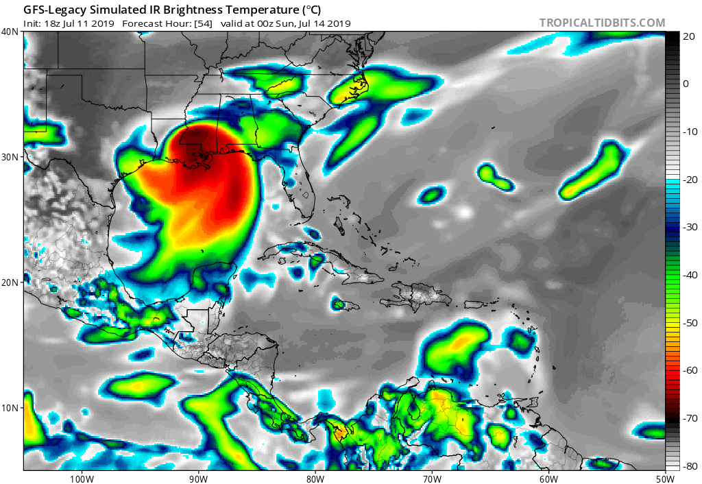
The GFS legacy consistent with putting NOLA in the crosshairs for a lot of rain and even some strong winds:
0 likes
Who is online
Users browsing this forum: No registered users and 30 guests