Area in the Bahamas: Is Invest 98L
Moderator: S2k Moderators
Forum rules

The posts in this forum are NOT official forecasts and should not be used as such. They are just the opinion of the poster and may or may not be backed by sound meteorological data. They are NOT endorsed by any professional institution or STORM2K. For official information, please refer to products from the National Hurricane Center and National Weather Service.
-
Aric Dunn
- Category 5

- Posts: 21228
- Age: 41
- Joined: Sun Sep 19, 2004 9:58 pm
- Location: Ready for the Chase.
- Contact:
Re: Area in the Bahamas
18z Traps it and moves it west central gulf.
0 likes
Note: If I make a post that is brief. Please refer back to previous posts for the analysis or reasoning. I do not re-write/qoute what my initial post said each time.
If there is nothing before... then just ask
Space & Atmospheric Physicist, Embry-Riddle Aeronautical University,
I believe the sky is falling...
If there is nothing before... then just ask
Space & Atmospheric Physicist, Embry-Riddle Aeronautical University,
I believe the sky is falling...

Re: Area in the Bahamas
cycloneye wrote:Something is starting to cook there.
https://twitter.com/DaDaBuh/status/1164282515517005825
I posted about that area yesterday.
0 likes

Re: Area in the Bahamas
Surface circulation is still far away from developing, I give it a good 48-72 hours before we see an LLC from developing, in the mean time it is just a mid level vorticity and a surface trough interacting with an UL trough aiding in development of convection as an UL ridge builds over the central GOM.
0 likes
-
Aric Dunn
- Category 5
- Posts: 21228
- Age: 41
- Joined: Sun Sep 19, 2004 9:58 pm
- Location: Ready for the Chase.
- Contact:
Re: Area in the Bahamas
Should see a distinct broad circ by tomorrow with a more defined circ by tomorrow evening into saturday as it reaches the straights.
0 likes
Note: If I make a post that is brief. Please refer back to previous posts for the analysis or reasoning. I do not re-write/qoute what my initial post said each time.
If there is nothing before... then just ask
Space & Atmospheric Physicist, Embry-Riddle Aeronautical University,
I believe the sky is falling...
If there is nothing before... then just ask
Space & Atmospheric Physicist, Embry-Riddle Aeronautical University,
I believe the sky is falling...
-
AtlanticWind

- S2K Supporter

- Posts: 1805
- Age: 65
- Joined: Sun Aug 08, 2004 9:57 pm
- Location: Plantation,Fla
Re: Area in the Bahamas
Aric Dunn wrote:Should see a distinct broad circ by tomorrow with a more defined circ by tomorrow evening into saturday as it reaches the straights.
Not impossible, but doesn't seem likely that it will form that fast.
Models don't support that.
But you never know ......
1 likes

Re: Area in the Bahamas
18z GFS brings vorticity into Florida panhandle.
https://www.tropicaltidbits.com/analysis/models/?model=gfs®ion=us&pkg=z850_vort&runtime=2019082118&fh=144
https://www.tropicaltidbits.com/analysis/models/?model=gfs®ion=us&pkg=z850_vort&runtime=2019082118&fh=144
1 likes
-
Aric Dunn
- Category 5
- Posts: 21228
- Age: 41
- Joined: Sun Sep 19, 2004 9:58 pm
- Location: Ready for the Chase.
- Contact:
Re: Area in the Bahamas
AtlanticWind wrote:Aric Dunn wrote:Should see a distinct broad circ by tomorrow with a more defined circ by tomorrow evening into saturday as it reaches the straights.
Not impossible, but doesn't seem likely that it will form that fast.
Models don't support that.
But you never know ......
Didn't say it would develop. just that we should see a better defined circ..
maybe borderline by then.
0 likes
Note: If I make a post that is brief. Please refer back to previous posts for the analysis or reasoning. I do not re-write/qoute what my initial post said each time.
If there is nothing before... then just ask
Space & Atmospheric Physicist, Embry-Riddle Aeronautical University,
I believe the sky is falling...
If there is nothing before... then just ask
Space & Atmospheric Physicist, Embry-Riddle Aeronautical University,
I believe the sky is falling...
-
stormhunter7

- Category 2

- Posts: 733
- Joined: Mon May 26, 2008 3:13 pm
- Location: Panama City Beach, Florida
- Contact:
Re: Area in the Bahamas
looks like 18z NAM brings a developing low across keys into SE GOM? (i should say similar to 18z GFZ)
1 likes
The following post is NOT an official forecast and should not be used as such. It is just the opinion of the poster and may or may not be backed by sound meteorological data. It is NOT endorsed by any professional institution including storm2k.org For Official Information please refer to the NHC and NWS products. http://www.nhc.noaa.gov
-
cycloneye

- Admin

- Posts: 139069
- Age: 67
- Joined: Thu Oct 10, 2002 10:54 am
- Location: San Juan, Puerto Rico
Re: Area in the Bahamas
An area of disorganized showers and thunderstorms, associated with a
trough of low pressure, extends over the Southeast and Central
Bahamas. Some slow development of this system is possible by late
this week as it drifts west-northwestward toward the Florida
peninsula. The system is expected to move generally northward near
the southeast coast of the United States and adjacent waters by
the end of the weekend.
* Formation chance through 48 hours...low...near 0 percent.
* Formation chance through 5 days...low...20 percent.
1 likes
Visit the Caribbean-Central America Weather Thread where you can find at first post web cams,radars
and observations from Caribbean basin members Click Here
and observations from Caribbean basin members Click Here
-
stormhunter7
- Category 2
- Posts: 733
- Joined: Mon May 26, 2008 3:13 pm
- Location: Panama City Beach, Florida
- Contact:
Re: Area in the Bahamas
cycloneye wrote:An area of disorganized showers and thunderstorms, associated with a
trough of low pressure, extends over the Southeast and Central
Bahamas. Some slow development of this system is possible by late
this week as it drifts west-northwestward toward the Florida
peninsula. The system is expected to move generally northward near
the southeast coast of the United States and adjacent waters by
the end of the weekend.
* Formation chance through 48 hours...low...near 0 percent.
* Formation chance through 5 days...low...20 percent.
Also know as the EURO solution... lol
0 likes
The following post is NOT an official forecast and should not be used as such. It is just the opinion of the poster and may or may not be backed by sound meteorological data. It is NOT endorsed by any professional institution including storm2k.org For Official Information please refer to the NHC and NWS products. http://www.nhc.noaa.gov
-
Aric Dunn
- Category 5
- Posts: 21228
- Age: 41
- Joined: Sun Sep 19, 2004 9:58 pm
- Location: Ready for the Chase.
- Contact:
Re: Area in the Bahamas
18z Euro looks like a lot of the vorticity get trapped and hangs over south florida and some of it get pulled NE..
not surprised really. given the setup. and that the 12z was Sooooo close to getting trapped.
not surprised really. given the setup. and that the 12z was Sooooo close to getting trapped.
0 likes
Note: If I make a post that is brief. Please refer back to previous posts for the analysis or reasoning. I do not re-write/qoute what my initial post said each time.
If there is nothing before... then just ask
Space & Atmospheric Physicist, Embry-Riddle Aeronautical University,
I believe the sky is falling...
If there is nothing before... then just ask
Space & Atmospheric Physicist, Embry-Riddle Aeronautical University,
I believe the sky is falling...
-
OuterBanker
- S2K Supporter
- Posts: 1704
- Joined: Wed Feb 26, 2003 10:53 am
- Location: Nags Head, NC
- Contact:

-
northjaxpro

- S2K Supporter
- Posts: 8900
- Joined: Mon Sep 27, 2010 11:21 am
- Location: Jacksonville, FL
Re: Area in the Bahamas
OuterBanker wrote:Is something trying to wrap around 25N 74W?
That is probably mid- level. However, that is an area to watch as we head into DMAX a bit later.
This will be gradual attaining a surface reflection. I will give it about another 24-36 hours at least to see a LLC develop in the Florida Straits.
0 likes
NEVER, EVER SAY NEVER in the tropics and weather in general, and most importantly, with life itself!!
________________________________________________________________________________________
Fay 2008 Beryl 2012 Debby 2012 Colin 2016 Hermine 2016 Julia 2016 Matthew 2016 Irma 2017 Dorian 2019
________________________________________________________________________________________
Fay 2008 Beryl 2012 Debby 2012 Colin 2016 Hermine 2016 Julia 2016 Matthew 2016 Irma 2017 Dorian 2019
-
Aric Dunn
- Category 5
- Posts: 21228
- Age: 41
- Joined: Sun Sep 19, 2004 9:58 pm
- Location: Ready for the Chase.
- Contact:
Re: Area in the Bahamas
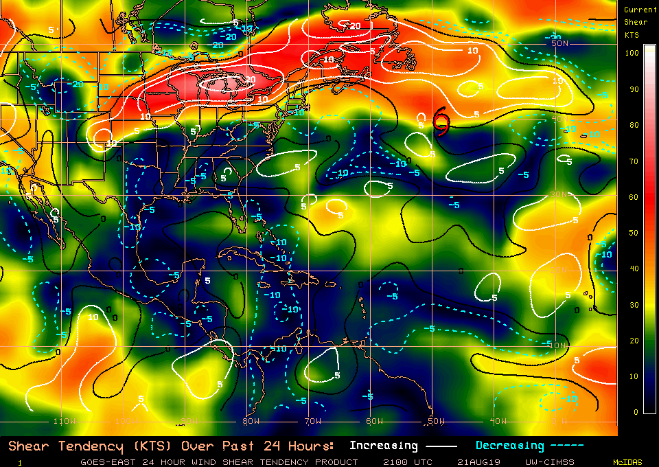
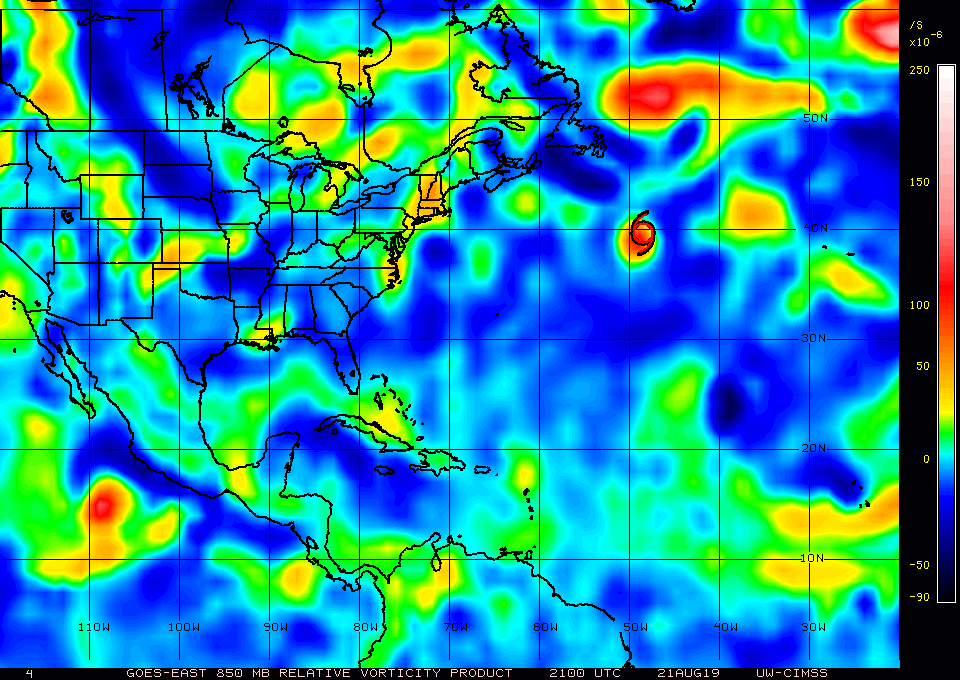
latest 10m Meso analysis.

850mb

850mb
1 likes
Note: If I make a post that is brief. Please refer back to previous posts for the analysis or reasoning. I do not re-write/qoute what my initial post said each time.
If there is nothing before... then just ask
Space & Atmospheric Physicist, Embry-Riddle Aeronautical University,
I believe the sky is falling...
If there is nothing before... then just ask
Space & Atmospheric Physicist, Embry-Riddle Aeronautical University,
I believe the sky is falling...
-
northjaxpro
- S2K Supporter
- Posts: 8900
- Joined: Mon Sep 27, 2010 11:21 am
- Location: Jacksonville, FL
Re: Area in the Bahamas
Pretty good signature currently midway between Andros Island and the Northern coast of Cuba.
Last edited by northjaxpro on Wed Aug 21, 2019 8:46 pm, edited 1 time in total.
0 likes
NEVER, EVER SAY NEVER in the tropics and weather in general, and most importantly, with life itself!!
________________________________________________________________________________________
Fay 2008 Beryl 2012 Debby 2012 Colin 2016 Hermine 2016 Julia 2016 Matthew 2016 Irma 2017 Dorian 2019
________________________________________________________________________________________
Fay 2008 Beryl 2012 Debby 2012 Colin 2016 Hermine 2016 Julia 2016 Matthew 2016 Irma 2017 Dorian 2019
-
Aric Dunn
- Category 5
- Posts: 21228
- Age: 41
- Joined: Sun Sep 19, 2004 9:58 pm
- Location: Ready for the Chase.
- Contact:
Re: Area in the Bahamas
northjaxpro wrote::uarrow: Yes the 850 mb vort has increased significantly since the morning analysis.
Pretty good signature currently midway between Andros Island and the Northern coast of Cuba.
The 10m wind meso analysis is also rather interesting.. If we get convection building near this area then yeah...
0 likes
Note: If I make a post that is brief. Please refer back to previous posts for the analysis or reasoning. I do not re-write/qoute what my initial post said each time.
If there is nothing before... then just ask
Space & Atmospheric Physicist, Embry-Riddle Aeronautical University,
I believe the sky is falling...
If there is nothing before... then just ask
Space & Atmospheric Physicist, Embry-Riddle Aeronautical University,
I believe the sky is falling...
Re: Area in the Bahamas
I think this disturbance has a good chance of reaching depression status if it gets into the GOM. We have several models showing low pressure forming ranging from 1010 to 1012 mb in the GOM. I'm guessing northerly shear will keep it in check from really developing until it gets into the SW Atlantic. But it could be a heavy rain producer for the FL peninsula.
1 likes
-
floridasun78
- Category 5
- Posts: 3755
- Joined: Sun May 17, 2009 10:16 pm
- Location: miami fl
Who is online
Users browsing this forum: kevin, South Texas Storms and 211 guests