

ATL: DORIAN - Models
Moderator: S2k Moderators
ATL: DORIAN - Models
Last edited by drezee on Sat Aug 24, 2019 5:19 pm, edited 1 time in total.
0 likes


Re: ATL: INVEST 99L - Models


1 likes
Very useful information on the Dvorak Technique --
https://severe.worldweather.wmo.int/TCF ... kBeven.pdf
https://severe.worldweather.wmo.int/TCF ... kBeven.pdf
-
Blown Away

- S2K Supporter

- Posts: 9861
- Joined: Wed May 26, 2004 6:17 am
Re: ATL: INVEST 99L - Models
Nice post 
Climatology usually wins over long range models beginning last week of August. Just a few short days ago it looked like nothing almost to September 10th...
Climatology usually wins over long range models beginning last week of August. Just a few short days ago it looked like nothing almost to September 10th...
6 likes
Hurricane Eye Experience: David 79, Irene 99, Frances 04, Jeanne 04, Wilma 05...
Hurricane Brush Experience: Andrew 92, Erin 95, Floyd 99, Matthew 16, Irma 17, Ian 22, Nicole 22…
Hurricane Brush Experience: Andrew 92, Erin 95, Floyd 99, Matthew 16, Irma 17, Ian 22, Nicole 22…
-
toad strangler

- S2K Supporter
- Posts: 4162
- Joined: Sun Jul 28, 2013 3:09 pm
- Location: Earth
- Contact:
Re: ATL: INVEST 99L - Models
Blown Away wrote:Nice post
Climatology usually wins over long range models beginning last week of August. Just a few short days ago it looked like nothing almost to September 10th...
Some take these models way too seriously. They know who they are.
4 likes

Re: ATL: INVEST 99L - Models
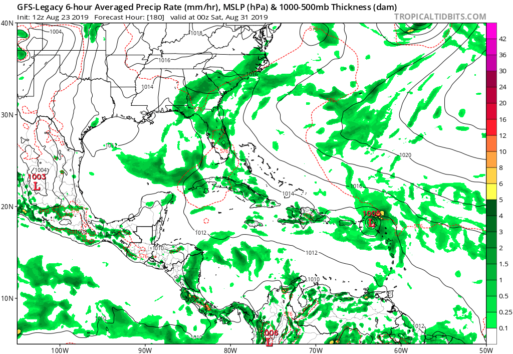
12z Legacy GFS and ICON both now develop this (and OP GFS still does) and bring it intact close to or over the Lesser Antilles. GFS has this blasted by shear after passing into the Caribbean. UKMET does not develop it.
0 likes


-
gatorcane

- S2K Supporter
- Posts: 23499
- Age: 46
- Joined: Sun Mar 13, 2005 3:54 pm
- Location: Boca Raton, FL
Re: ATL: INVEST 99L - Models
CMC finally shows a TC in the Atlantic and is much more north of the GFS:
1 likes
-
AtlanticWind

- S2K Supporter
- Posts: 1805
- Age: 65
- Joined: Sun Aug 08, 2004 9:57 pm
- Location: Plantation,Fla
Re: ATL: INVEST 99L - Models
GFS quickly shears this apart after entering th carribean, a little far out to know if
the model is correct on this.
the model is correct on this.
4 likes

Re: ATL: INVEST 99L - Models
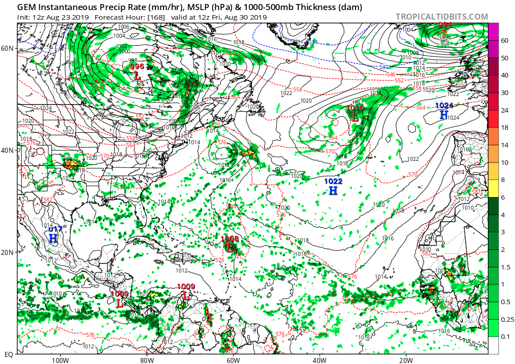
I'll bite since GEM is on board, as it's the only model of the main three that correctly never showed the GoM system developing.
2 likes
The above post is not official and should not be used as such. It is the opinion of the poster and may or may not be backed by sound meteorological data. It is not endorsed by any professional institution or storm2k.org. For official information, please refer to the NHC and NWS products.
-
AtlanticWind
- S2K Supporter
- Posts: 1805
- Age: 65
- Joined: Sun Aug 08, 2004 9:57 pm
- Location: Plantation,Fla
Re: ATL: INVEST 99L - Models
Also HMON and HWRF don't do much with 99l which is kind of surprising since they are based off the GFS.
0 likes
-
toad strangler
- S2K Supporter
- Posts: 4162
- Joined: Sun Jul 28, 2013 3:09 pm
- Location: Earth
- Contact:
Re: ATL: INVEST 99L - Models
AtlanticWind wrote:GFS quickly shears this apart after entering th carribean, a little far out to know if
the model is correct on this.
And buries what's left of vorticity into SA uber long range
0 likes
-
bamajammer4eva
- Category 4

- Posts: 907
- Joined: Sun Apr 18, 2010 3:21 am
- Location: Ozark, AL

-
galaxy401

- Category 5

- Posts: 2298
- Age: 28
- Joined: Sat Aug 25, 2012 9:04 pm
- Location: Casa Grande, Arizona
Re: ATL: INVEST 99L - Models
Blown Away wrote:Nice post
Climatology usually wins over long range models beginning last week of August. Just a few short days ago it looked like nothing almost to September 10th...
That's why I always discard any model runs in late August that shows nothing through September. Due to climatology, there's always at least one system that will develop.
2 likes
Got my eyes on moving right into Hurricane Alley: Florida.
-
gatorcane
- S2K Supporter
- Posts: 23499
- Age: 46
- Joined: Sun Mar 13, 2005 3:54 pm
- Location: Boca Raton, FL
Re: ATL: INVEST 99L - Models
Legacy GFS shows a more robust system than the previous run and is more north of the new GFS:
1 likes
-
tolakram
- Admin

- Posts: 19165
- Age: 60
- Joined: Sun Aug 27, 2006 8:23 pm
- Location: Florence, KY (name is Mark)
Re: ATL: INVEST 99L - Models
Euro can't ignore it now.

3 likes
M a r k
- - - - -
Join us in chat: Storm2K Chatroom Invite. Android and IOS apps also available.
The posts in this forum are NOT official forecasts and should not be used as such. Posts are NOT endorsed by any professional institution or STORM2K.org. For official information and forecasts, please refer to NHC and NWS products.
-
toad strangler
- S2K Supporter
- Posts: 4162
- Joined: Sun Jul 28, 2013 3:09 pm
- Location: Earth
- Contact:
Re: ATL: INVEST 99L - Models
Euro much further N than the GFS and weak. Possibly getting sucked into would be Dorian weakness.
0 likes
-
SFLcane

- S2K Supporter
- Posts: 9606
- Age: 46
- Joined: Sat Jun 05, 2010 1:44 pm
- Location: Lake Worth Florida
Re: ATL: INVEST 99L - Models
ECMWF barely develops 99L infact shows it weakening as it nears the islands into a wave possibly. Conditions clearly are not that favorable
1 likes
-
AutoPenalti
- Category 5
- Posts: 3949
- Age: 27
- Joined: Mon Aug 17, 2015 4:16 pm
- Location: Ft. Lauderdale, Florida
Re: ATL: INVEST 99L - Models
Siding with the Euro on this one, MDR is still too hostile and shear is waiting for it in the Caribbean.
0 likes
The posts in this forum are NOT official forecasts and should not be used as such. They are just the opinion of the poster and may or may not be backed by sound meteorological data. They are NOT endorsed by any professional institution or STORM2K. For official information, please refer to products from the NHC and NWS.
Model Runs Cheat Sheet:
GFS (5:30 AM/PM, 11:30 AM/PM)
HWRF, GFDL, UKMET, NAVGEM (6:30-8:00 AM/PM, 12:30-2:00 AM/PM)
ECMWF (1:45 AM/PM)
TCVN is a weighted averaged
-
NotSparta

- Professional-Met

- Posts: 1645
- Age: 22
- Joined: Fri Aug 18, 2017 8:24 am
- Location: Naples, FL
- Contact:
Re: ATL: INVEST 99L - Models
AutoPenalti wrote:Siding with the Euro on this one, MDR is still too hostile and shear is waiting for it in the Caribbean.
That's a bold strategy, given that run practically caved to the GFS wrt development
3 likes
This post was probably an opinion of mine, and in no way is official. Please refer to http://www.hurricanes.gov for official tropical analysis and advisories.
My website, with lots of tropical wx graphics, including satellite and recon: http://cyclonicwx.com
My website, with lots of tropical wx graphics, including satellite and recon: http://cyclonicwx.com
Who is online
Users browsing this forum: No registered users and 52 guests