ATL: MELISSA - Post-Tropical - Discussion
Moderator: S2k Moderators
-
Sciencerocks
- Category 5

- Posts: 7287
- Age: 38
- Joined: Thu Jul 06, 2017 1:51 am
-
AnnularCane

- S2K Supporter

- Posts: 2636
- Joined: Thu Jun 08, 2006 9:18 am
- Location: Wytheville, VA

Re: ATL: MELISSA - Subtropical Storm - Discussion
She is also sinking south on the back side of the cold front..
0 likes
-
CrazyC83
- Professional-Met

- Posts: 33393
- Joined: Tue Mar 07, 2006 11:57 pm
- Location: Deep South, for the first time!
Re: ATL: MELISSA - Subtropical Storm - Discussion
Nimbus wrote:She is also sinking south on the back side of the cold front..
That drives it into warmer waters as well.
0 likes
-
Sciencerocks
- Category 5
- Posts: 7287
- Age: 38
- Joined: Thu Jul 06, 2017 1:51 am
-
EquusStorm

- Category 5
- Posts: 1649
- Age: 33
- Joined: Thu Nov 07, 2013 1:04 pm
- Location: Jasper, AL
- Contact:
Re: ATL: MELISSA - Subtropical Storm - Discussion
Would probably become a full embedded mini-cane a la Halloween 1991 and Karl 1980, but shear is already increasing (and sustained winds beginning to drop) so time is not on its side. Then again, 24 hours ago it wasn't even supposed to happen at all.
0 likes
Colors of lost purpose on the canvas of irrelevance
Not a meteorologist, in fact more of an idiot than anything. You should probably check with the NHC or a local NWS office for official information.
Not a meteorologist, in fact more of an idiot than anything. You should probably check with the NHC or a local NWS office for official information.

Re: ATL: MELISSA - Subtropical Storm - Discussion
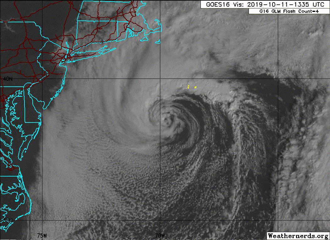
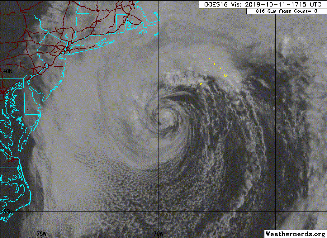
The evolution of this system is certainly interesting. It's uncommon for a coastal low such as this to directly transform into a subtropical cyclone. On conventional satellite imagery, Melissa resembles a classical nor'easter, but a warm core is quite evident on phase diagrams.
2 likes

Re: ATL: MELISSA - Subtropical Storm - Discussion
Haven't checked the weather for a few days (aside from the NHC map late last night), come back to a subtropical storm. This has to be one of the fastest anything's gone from having no invest to being upgraded in quite some time.
2 likes
The above post is not official and should not be used as such. It is the opinion of the poster and may or may not be backed by sound meteorological data. It is not endorsed by any professional institution or storm2k.org. For official information, please refer to the NHC and NWS products.
-
Sciencerocks
- Category 5
- Posts: 7287
- Age: 38
- Joined: Thu Jul 06, 2017 1:51 am
Re: ATL: MELISSA - Subtropical Storm - Discussion
Convection is building over the center and decreasing further out. Sure sign that it is becoming tropical in nature! We will see if a more respectful burst of convection forms later tonight to allow it to become a tropical storm.
2 likes
-
CrazyC83
- Professional-Met
- Posts: 33393
- Joined: Tue Mar 07, 2006 11:57 pm
- Location: Deep South, for the first time!
Re: ATL: MELISSA - Subtropical Storm - Discussion
If this drops south into the Gulf Stream, it could strengthen on its own. I wonder if the (sub)tropical cyclogenesis will be moved up to earlier? Also the peak intensity was probably yesterday as an ET system.
1 likes
Re: ATL: MELISSA - Subtropical Storm - Discussion
After reviewing the satellite loop over the last day or so, it looks like genesis began late last night as the previous invest merged with it which was when the convection exploded.
0 likes
The above post is not official and should not be used as such. It is the opinion of the poster and may or may not be backed by sound meteorological data. It is not endorsed by any professional institution or storm2k.org. For official information, please refer to the NHC and NWS products.
-
Sciencerocks
- Category 5
- Posts: 7287
- Age: 38
- Joined: Thu Jul 06, 2017 1:51 am
Re: ATL: MELISSA - Subtropical Storm - Discussion
There's our convection burst over the center!
2 likes
-
northjaxpro

- S2K Supporter
- Posts: 8900
- Joined: Mon Sep 27, 2010 11:21 am
- Location: Jacksonville, FL
Re: ATL: MELISSA - Subtropical Storm - Discussion
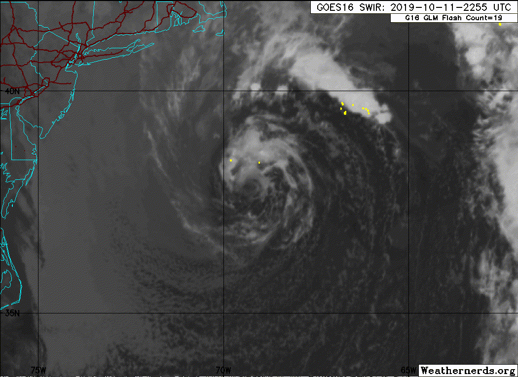
Convection has sustained, and actually has enhanced around the center of circulation overnight and into this morning. Plus, Melissa drifted into a bit south /southeast into warmer ssts the past 12 -18 hours and thus she has fed off of that. I would make a case that she has transitioned to a fully tropical cyclone. She looks pretty good this morning. I would bet she's a bit stronger right now as well. Melissa is reaching her peak now. Probably at least around 60 mph or so currently near the center. Strong TS for sure. She won't make cane status as drier air and wind shear will eventually put the whammy on her. A nice mid-latitude cyclone nonetheless in the North Atlantic basin.
3 likes
NEVER, EVER SAY NEVER in the tropics and weather in general, and most importantly, with life itself!!
________________________________________________________________________________________
Fay 2008 Beryl 2012 Debby 2012 Colin 2016 Hermine 2016 Julia 2016 Matthew 2016 Irma 2017 Dorian 2019
________________________________________________________________________________________
Fay 2008 Beryl 2012 Debby 2012 Colin 2016 Hermine 2016 Julia 2016 Matthew 2016 Irma 2017 Dorian 2019
-
cycloneye

- Admin

- Posts: 139168
- Age: 67
- Joined: Thu Oct 10, 2002 10:54 am
- Location: San Juan, Puerto Rico
Re: ATL: MELISSA - Subtropical Storm - Discussion
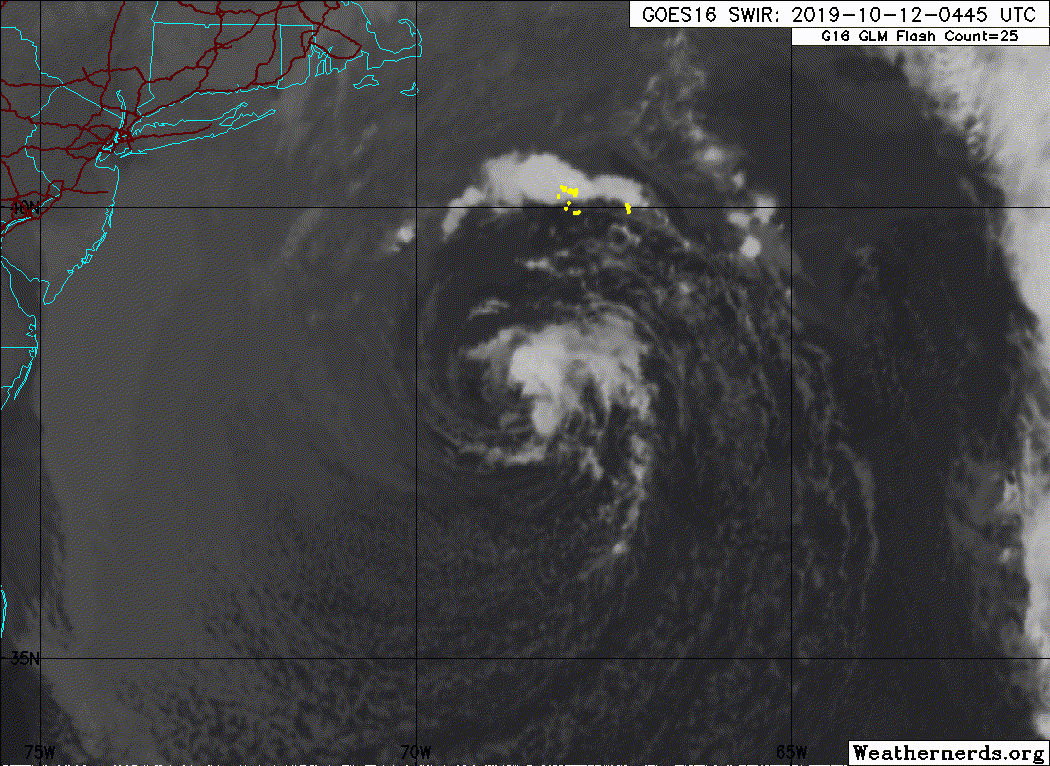
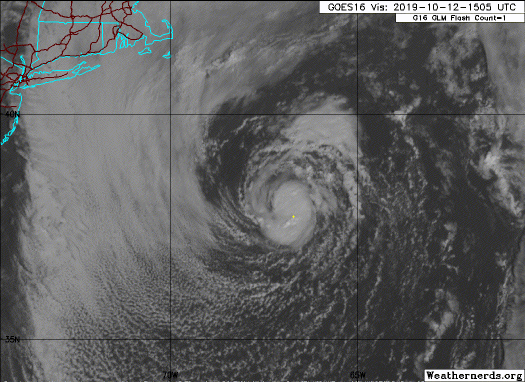
BULLETIN
Subtropical Storm Melissa Advisory Number 5
NWS National Hurricane Center Miami FL AL142019
1100 AM AST Sat Oct 12 2019
...MELISSA MOVING AWAY FROM THE MID-ATLANTIC AND NORTHEAST U.S.
COAST...
SUMMARY OF 1100 AM AST...1500 UTC...INFORMATION
-----------------------------------------------
LOCATION...38.1N 67.0W
ABOUT 265 MI...430 KM SE OF NANTUCKET MASSACHUSETTS
MAXIMUM SUSTAINED WINDS...50 MPH...85 KM/H
PRESENT MOVEMENT...ENE OR 70 DEGREES AT 10 MPH...17 KM/H
MINIMUM CENTRAL PRESSURE...998 MB...29.47 INCHES
WATCHES AND WARNINGS
--------------------
There are no coastal tropical cyclone watches or warnings in effect.
For information on coastal flooding hazards, see products issued by
your local National Weather Service office at weather.gov.
DISCUSSION AND OUTLOOK
----------------------
At 1100 AM AST (1500 UTC), the center of Subtropical Storm Melissa
was located near latitude 38.1 North, longitude 67.0 West. Melissa
is moving toward the east-northeast near 10 mph (17 km/h). A gradual
increase in forward speed is expected tonight through Monday. On the
forecast track, Melissa will continue to move away from the U.S.
Mid-Atlantic and New England coasts.
Maximum sustained winds are near 50 mph (85 km/h) with higher gusts.
Slow weakening is expected today, with a faster rate of weakening
tonight. Melissa is forecast to become a post-tropical remnant low
by Sunday.
Winds of 40 mph extend outward up to 175 miles (280 km) from the
center.
The estimated minimum central pressure is 998 mb (29.47 inches).
HAZARDS AFFECTING LAND
----------------------
COASTAL FLOODING: Minor to moderate coastal flooding will occur
along some portions of the U.S. Mid-Atlantic and southeastern New
England coast today around times of high tide.
SURF: Swells generated by Melissa are affecting much of the U.S.
east coast, portions of the Bahamas, Bermuda, and Atlantic Canada.
These swells will result in life-threatening surf and rip current
conditions. Please consult products from your local weather office.
NEXT ADVISORY
-------------
Next complete advisory at 500 PM AST.
$$
Forecaster Latto
Subtropical Storm Melissa Discussion Number 5
NWS National Hurricane Center Miami FL AL142019
1100 AM AST Sat Oct 12 2019
A small area of deep convection has persisted for the past several
hours over and around the center of Melissa. Recent AMSU microwave
temperature data indicate that a warm core exists at least above 550
mb. It is uncertain, however, if this warm core is due to the
intrusion of warmer temperatures aloft embedded in the upper trough
over Melissa, or if the warming was induced by convective feedback.
If deep convection persists into the afternoon, then it is more
likely that the warm core is due to the convection, and Melissa
could transition to a tropical cyclone by that time. Based on
nearby surface observations, the wind field immediately surrounding
Melissa has contracted, with no evidence of gale-force winds beyond
150 n mi from the center. Given the convection near the center, the
strongest winds are now most likely occurring in that region. The
latest Hebert-Poteat subtropical satellite intensity estimate from
TAFB is 45-50 kt, and UW-CIMSS ADT and SATCON tropical estimates are
41 kt and 42 kt, respectively. Therefore, the initial intensity is
being held at 45 kt.
The upper trough over Melissa is forecast to weaken and lift
northeastward through tonight, which would remove the upper-level
support for the subtropical storm. Increasing westerly wind shear
and progressively cooler SSTs should weaken the cyclone over the
next few days, with Melissa moving over waters of 23-24 C tonight.
This should cause the cyclone to lose its convection and transition
to a remnant low by Sunday. The post-tropical cyclone is expected
to persist for a couple of days just ahead of a frontal zone before
it is finally absorbed by the front in 3-4 days. The NHC forecast
is near the consensus aids at 12 hours, but a little below that
guidance through Sunday, as the global models appear to be capturing
the strongest winds in a frontal zone well-removed to the northeast
of Melissa, and not directly associated with the cyclone itself.
Melissa is now moving east-northeastward, or 070/08 kt. Increasing
westerly flow will cause the cyclone to accelerate tonight through
Monday. This motion will continue until the cyclone is absorbed by
a frontal zone. The new NHC track forecast is close to the previous
one and in the middle of the various consensus aids.
Ongoing hazards from coastal flooding will continue to be covered by
non-tropical products from local National Weather Service forecast
offices.
Gale-force winds that extend from offshore of Nova Scotia eastward
over the Atlantic are not included in the wind radii since they are
associated with a frontal boundary.
Key Messages:
1. Melissa is expected to slowly weaken and move away from the
U.S. east coast today, resulting in a gradual decrease in wind and
coastal flooding impacts.
2. Minor to moderate coastal flooding is still expected along
portions of the U.S. Mid-Atlantic and southeastern New England
coasts around times of high tide today. For more information,
see products issued by local National Weather Service forecast
offices at weather.gov.
FORECAST POSITIONS AND MAX WINDS
INIT 12/1500Z 38.1N 67.0W 45 KT 50 MPH
12H 13/0000Z 38.7N 65.2W 40 KT 45 MPH
24H 13/1200Z 39.6N 62.0W 30 KT 35 MPH...POST-TROP/REMNT LOW
36H 14/0000Z 40.3N 58.2W 30 KT 35 MPH...POST-TROP/REMNT LOW
48H 14/1200Z 41.0N 54.3W 30 KT 35 MPH...POST-TROP/REMNT LOW
72H 15/1200Z 42.2N 45.0W 25 KT 30 MPH...POST-TROP/REMNT LOW
96H 16/1200Z...ABSORBED BY A FRONTAL ZONE
$$
Forecaster Latto
0 likes
Visit the Caribbean-Central America Weather Thread where you can find at first post web cams,radars
and observations from Caribbean basin members Click Here
and observations from Caribbean basin members Click Here
-
supercane4867
- Category 5
- Posts: 4966
- Joined: Wed Nov 14, 2012 10:43 am

-
cycloneye
- Admin
- Posts: 139168
- Age: 67
- Joined: Thu Oct 10, 2002 10:54 am
- Location: San Juan, Puerto Rico
Re: ATL: MELISSA - Subtropical Storm - Discussion
From 11 AM EDT discussion:
Recent AMSU microwave
temperature data indicate that a warm core exists at least above 550
mb. It is uncertain, however, if this warm core is due to the
intrusion of warmer temperatures aloft embedded in the upper trough
over Melissa, or if the warming was induced by convective feedback.
If deep convection persists into the afternoon, then it is more
likely that the warm core is due to the convection, and Melissa
could transition to a tropical cyclone by that time.
0 likes
Visit the Caribbean-Central America Weather Thread where you can find at first post web cams,radars
and observations from Caribbean basin members Click Here
and observations from Caribbean basin members Click Here
-
AnnularCane
- S2K Supporter
- Posts: 2636
- Joined: Thu Jun 08, 2006 9:18 am
- Location: Wytheville, VA
Re: ATL: MELISSA - Subtropical Storm - Discussion
Is there any chance she might live longer than they say?
0 likes
-
OuterBanker
- S2K Supporter
- Posts: 1704
- Joined: Wed Feb 26, 2003 10:53 am
- Location: Nags Head, NC
- Contact:
Re: ATL: MELISSA - Subtropical Storm - Discussion
Farewell Melissa, and good riddance.
She hung around long enough to do some real damage on Hatteras island.
She knocked down dunes that did protect highway 12 (the only route on and off island).
Here are some examples of what she did here.
https://islandfreepress.org/outer-banks ... lide-show/
She hung around long enough to do some real damage on Hatteras island.
She knocked down dunes that did protect highway 12 (the only route on and off island).
Here are some examples of what she did here.
https://islandfreepress.org/outer-banks ... lide-show/
1 likes
-
Sciencerocks
- Category 5
- Posts: 7287
- Age: 38
- Joined: Thu Jul 06, 2017 1:51 am
-
Hypercane_Kyle

- Category 5
- Posts: 2900
- Joined: Sat Mar 07, 2015 7:58 pm
- Location: Cape Canaveral, FL
Re: ATL: MELISSA - Subtropical Storm - Discussion
Fully tropical now per 18z ATCF.
4 likes
My posts are my own personal opinion, defer to the National Hurricane Center (NHC) and other NOAA products for decision making during hurricane season.
Who is online
Users browsing this forum: No registered users and 58 guests