ATL: FIFTEEN - Remnants - Discussion
Moderator: S2k Moderators
-
CyclonicFury

- Category 5

- Posts: 1975
- Age: 25
- Joined: Sun Jul 02, 2017 12:32 pm
- Location: NC
- Contact:
Re: ATL: FIFTEEN - Tropical Depression - Discussion
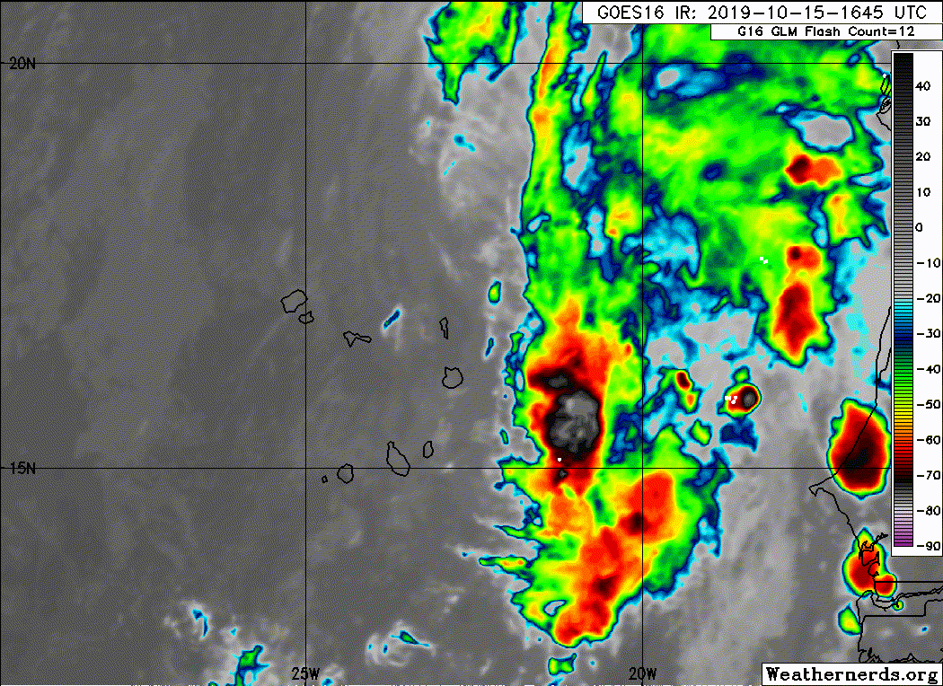
ADT is just an automated Dvorak estimate that often performs poorly with weak systems such as 15L. The ASCAT data, as well as the TAFB and SAB Dvorak estimates (the latter of which deemed 15L too weak to classify), only support an intensity of 25-30 kt. In addition, the circulation appears less defined than yesterday.
1 likes
NCSU B.S. in Meteorology Class of 2021. Tropical weather blogger at http://www.cyclonicfury.com. My forecasts and thoughts are NOT official, for official forecasts please consult the National Hurricane Center.
-
northjaxpro

- S2K Supporter

- Posts: 8900
- Joined: Mon Sep 27, 2010 11:21 am
- Location: Jacksonville, FL
Re: ATL: FIFTEEN - Tropical Depression - Discussion
Next...
1 likes
NEVER, EVER SAY NEVER in the tropics and weather in general, and most importantly, with life itself!!
________________________________________________________________________________________
Fay 2008 Beryl 2012 Debby 2012 Colin 2016 Hermine 2016 Julia 2016 Matthew 2016 Irma 2017 Dorian 2019
________________________________________________________________________________________
Fay 2008 Beryl 2012 Debby 2012 Colin 2016 Hermine 2016 Julia 2016 Matthew 2016 Irma 2017 Dorian 2019
-
Sciencerocks
- Category 5
- Posts: 7286
- Age: 38
- Joined: Thu Jul 06, 2017 1:51 am
-
cycloneye

- Admin

- Posts: 139060
- Age: 67
- Joined: Thu Oct 10, 2002 10:54 am
- Location: San Juan, Puerto Rico
Re: ATL: FIFTEEN - Tropical Depression - Discussion
BULLETIN
Tropical Depression Fifteen Advisory Number 5
NWS National Hurricane Center Miami FL AL152019
500 PM AST Tue Oct 15 2019
...DEPRESSION MOVING OVER THE NORTHEASTERN CABO VERDE ISLANDS...
SUMMARY OF 500 PM AST...2100 UTC...INFORMATION
----------------------------------------------
LOCATION...16.8N 22.9W
ABOUT 90 MI...145 KM NE OF THE CABO VERDE ISLANDS
MAXIMUM SUSTAINED WINDS...35 MPH...55 KM/H
PRESENT MOVEMENT...NW OR 315 DEGREES AT 10 MPH...17 KM/H
MINIMUM CENTRAL PRESSURE...1007 MB...29.74 INCHES
WATCHES AND WARNINGS
--------------------
There are no coastal watches or warnings in effect.
Interests in the Cabo Verde Islands should closely monitor the
progress of the depression.
DISCUSSION AND OUTLOOK
----------------------
At 500 PM AST (2100 UTC), the center of Tropical Depression Fifteen
was located near latitude 16.8 North, longitude 22.9 West. The
depression is moving toward the northwest near 10 mph (17 km/h), and
this general motion is expected to continue through Wednesday. On
the forecast track, the center of the depression will move across
the island of Sal this evening and over or near the northern Cabo
Verde Islands tonight and early Wednesday morning.
Satellite-derived wind data indicate that maximum sustained winds
remain near 35 mph (55 km/h) with higher gusts. Little change in
strength is forecast tonight and early Wednesday. Weakening is
expected to begin by Wednesday afternoon, and the system is
forecast to become a remnant low by Wednesday night or Thursday.
The estimated minimum central pressure is 1007 mb (29.74 inches) is
based on observations from the Amilcar Cabral Airport on Sal island.
HAZARDS AFFECTING LAND
----------------------
RAINFALL: The depression is expected to produce total rainfall
accumulations of 1 to 3 inches across the eastern and northern Cabo
Verde Islands through Wednesday. This rainfall could cause flash
flooding and mudslides.
WIND: Tropical-storm-force wind gusts could occur across the
eastern Cabo Verde Islands later today and tonight, especially
over higher terrain.
NEXT ADVISORY
-------------
Next complete advisory at 1100 PM AST.
$$
Forecaster Stewart
Tropical Depression Fifteen Discussion Number 5
NWS National Hurricane Center Miami FL AL152019
500 PM AST Tue Oct 15 2019
The multiple circulations mentioned in the previous advisory
discussion now appear to have consolidated into a tight low-level
center that has recently passed over or near Sal island in the
northeastern Cabo Verde archipelago. Deep convection has increased
slightly and now consists of an elongated band confined to the
eastern semicircle due to modest southwesterly vertical wind shear,
leaving the low-level center exposed to the west. A late-arriving
1128Z ASCAT-C scatterometer pass indicated several 28-29 kt surface
wind vectors within the band of convection, which supports
maintaining an intensity of 30 kt.
The initial motion remains northwestward, or 315/09 kt. There is no
significant change to the previous forecast track or rationale. The
latest NHC model guidance remains in very good agreement that the
large cyclone will move generally northwestward during the next 48
hours or so, followed by a turn to the west-northwest when the
expected shallow system will become embedded in the brisk low-level
easterly trade wind flow. The new official track forecast is similar
to the previous advisory track, and lies just to the left of the
HCCA and TVCN consensus models.
The environmental conditions are expected to only be marginal, so
little, if any, strengthening is anticipated during the next 12
hours. By 24 hours and beyond, the combination of strong
southwesterly vertical wind shear, drier and more stable air, and
SSTs less than 26C should cause steady to rapid weakening, resulting
in the cyclone degenerating into a remnant low by 36 hours and
dissipating shortly after 72 hours, if not sooner.
Regardless of whether or not the depression becomes a tropical storm
as it passes near the Cabo Verde Islands, the primary threat from
this system is the potential for locally heavy rainfall and flash
flooding in those islands.
FORECAST POSITIONS AND MAX WINDS
INIT 15/2100Z 16.8N 22.9W 30 KT 35 MPH
12H 16/0600Z 17.8N 23.7W 30 KT 35 MPH
24H 16/1800Z 19.0N 24.8W 25 KT 30 MPH
36H 17/0600Z 19.9N 26.3W 25 KT 30 MPH...POST-TROP/REMNT LOW
48H 17/1800Z 21.2N 28.0W 20 KT 25 MPH...POST-TROP/REMNT LOW
72H 18/1800Z 23.0N 32.0W 20 KT 25 MPH...POST-TROP/REMNT LOW
96H 19/1800Z...DISSIPATED
$$
Forecaster Stewart
1 likes
Visit the Caribbean-Central America Weather Thread where you can find at first post web cams,radars
and observations from Caribbean basin members Click Here
and observations from Caribbean basin members Click Here
-
AnnularCane

- S2K Supporter
- Posts: 2634
- Joined: Thu Jun 08, 2006 9:18 am
- Location: Wytheville, VA
Re: ATL: FIFTEEN - Tropical Depression - Discussion
Maybe TD 15 doesn't really want to be stuck with the name "Nestor." 
1 likes
-
cycloneye
- Admin
- Posts: 139060
- Age: 67
- Joined: Thu Oct 10, 2002 10:54 am
- Location: San Juan, Puerto Rico
Re: ATL: FIFTEEN - Tropical Depression - Discussion
BULLETIN
Tropical Depression Fifteen Advisory Number 6
NWS National Hurricane Center Miami FL AL152019
1100 PM AST Tue Oct 15 2019
...POORLY ORGANIZED DEPRESSION CONTINUES TO MOVE NEAR THE
NORTHEASTERN CABO VERDE ISLANDS...
SUMMARY OF 1100 PM AST...0300 UTC...INFORMATION
-----------------------------------------------
LOCATION...16.8N 23.7W
ABOUT 60 MI...95 KM NNE OF THE CABO VERDE ISLANDS
MAXIMUM SUSTAINED WINDS...35 MPH...55 KM/H
PRESENT MOVEMENT...WNW OR 300 DEGREES AT 10 MPH...17 KM/H
MINIMUM CENTRAL PRESSURE...1009 MB...29.80 INCHES
WATCHES AND WARNINGS
--------------------
There are no coastal watches or warnings in effect.
Interests in the Cabo Verde Islands should monitor the progress of
the depression.
DISCUSSION AND OUTLOOK
----------------------
At 1100 PM AST (0300 UTC), the center of Tropical Depression Fifteen
was located near latitude 16.8 North, longitude 23.7 West. The
depression is moving toward the west-northwest near 10 mph
(17 km/h). The depression is forecast to move on a
west-northwestward to northwestward heading at a similar forward
speed during the next day or two.
Recent satellite-derived wind data indicate that the maximum
sustained winds remain near 35 mph (55 km/h) with higher gusts.
Gradual weakening is anticipated, and the system is forecast to
become a remnant low on Wednesday.
The estimated minimum central pressure is 1009 mb (29.80 inches)
based on data from the Amilcar Cabral International Airport (GVAC)
in the Cabo Verde Islands.
HAZARDS AFFECTING LAND
----------------------
RAINFALL: The depression is expected to produce total rainfall
accumulations of 1 to 3 inches across the eastern and northern Cabo
Verde Islands through Wednesday. This rainfall could cause flash
flooding and mudslides.
WIND: Tropical-storm-force wind gusts could occur across the
eastern Cabo Verde Islands through Wednesday, especially over high
terrain.
NEXT ADVISORY
-------------
Next complete advisory at 500 AM AST.
$$
Forecaster Zelinsky
Tropical Depression Fifteen Discussion Number 6
NWS National Hurricane Center Miami FL AL152019
1100 PM AST Tue Oct 15 2019
The tropical depression located near the Cabo Verde Islands has
become less organized over the past 6 hours. An ASCAT-A overpass at
2154 UTC showed that the depression still had a closed and
well-defined center, but the strongest winds were only 20-25 kt. A
subsequent ASCAT-B pass about 1 hour later showed slightly higher
winds but an elongated circulation. Furthermore, deep convection is
limited to a small area of showers located nearly 100 n mi to the
east of the depression's center. If its convection continues to
decrease, the system could become a remnant low later today.
Alternatively, if its circulation continues to become elongated, it
could soon open into a trough and dissipate. Either way, it seems
unlikely that the depression will remain a tropical cyclone for
long, and this shown by all of the models and the official forecast.
The depression has made a westward jog since the last advisory, but
a longer-term motion estimate is 300/09 kt. The westward jog
resulted in a substantial westward shift in the official forecast
track, but the system is still expected to move generally
west-northwestward to northwestward for the next day or two until it
dissipates. The track guidance is in good agreement on this
scenario, and the main source of uncertainty is just how quickly the
system will open into a trough.
The latest ECMWF deterministic forecast and few of its ensemble
members indicate that the cyclone could regenerate later this week.
However, most other models do not forecast regeneration and the
uncertainty is too high to justify explicitly showing this in the
official forecast.
FORECAST POSITIONS AND MAX WINDS
INIT 16/0300Z 16.8N 23.7W 30 KT 35 MPH
12H 16/1200Z 17.7N 24.6W 30 KT 35 MPH
24H 17/0000Z 18.6N 25.7W 25 KT 30 MPH...POST-TROP/REMNT LOW
36H 17/1200Z 19.6N 27.2W 25 KT 30 MPH...POST-TROP/REMNT LOW
48H 18/0000Z 20.8N 29.3W 20 KT 25 MPH...POST-TROP/REMNT LOW
72H 19/0000Z...DISSIPATED
$$
Forecaster Zelinsky
0 likes
Visit the Caribbean-Central America Weather Thread where you can find at first post web cams,radars
and observations from Caribbean basin members Click Here
and observations from Caribbean basin members Click Here
-
AJC3

- Admin
- Posts: 3871
- Age: 60
- Joined: Tue Aug 31, 2004 7:04 pm
- Location: West Melbourne, Florida
- Contact:
Re: ATL: FIFTEEN - Remnants - Discussion
Gone...
BULLETIN
Remnants Of Fifteen Advisory Number 7
NWS National Hurricane Center Miami FL AL152019
500 AM AST Wed Oct 16 2019
...LAST ADVISORY AS DEPRESSION DEGENERATED INTO A TROUGH...
SUMMARY OF 500 AM AST...0900 UTC...INFORMATION
----------------------------------------------
LOCATION...17.3N 24.1W
ABOUT 90 MI...145 KM N OF THE CABO VERDE ISLANDS
MAXIMUM SUSTAINED WINDS...30 MPH...45 KM/H
PRESENT MOVEMENT...NW OR 305 DEGREES AT 8 MPH...13 KM/H
MINIMUM CENTRAL PRESSURE...1009 MB...29.80 INCHES
WATCHES AND WARNINGS
--------------------
None.
DISCUSSION AND OUTLOOK
----------------------
At 500 AM AST (0900 UTC), the remnants of Fifteen were located near
latitude 17.3 North, longitude 24.1 West. The remnants are moving
toward the northwest near 8 mph (13 km/h), and that motion
should continue today.
Maximum sustained winds are near 30 mph (45 km/h) with higher gusts.
The system should weaken further today.
The estimated minimum central pressure is 1009 mb (29.80 inches).
HAZARDS AFFECTING LAND
----------------------
None.
NEXT ADVISORY
-------------
This is the last public advisory issued by the National Hurricane
Center on this system. Additional information on this system can be
found in High Seas Forecasts issued by Meteo France under WMO header
FQNT50 LFPW and available on the web at
www.meteofrance.com/previsions-meteo-ma ... randlarge/
metarea2
Remnants Of Fifteen Discussion Number 7
NWS National Hurricane Center Miami FL AL152019
500 AM AST Wed Oct 16 2019
Satellite images indicate that the surface circulation of the
system has become rather elongated north-to-south, with only a few
weak swirls in the circulation envelope, and has degenerated into a
trough of low pressure. Thus it is no longer a tropical cyclone,
and this is the last advisory. The winds are lowered to 25 kt,
matching the TAFB classification.
The remnants of the cyclone are expected to move northwestward
during the next few days. There is a slight chance of
regeneration, as suggested by the ECMWF model and some of its
ensemble members due to a trough interaction, but that's considered
unlikely at this point.
FORECAST POSITIONS AND MAX WINDS
INIT 16/0900Z 17.3N 24.1W 25 KT 30 MPH
12H 16/1800Z...DISSIPATED
0 likes
-
HurricaneBelle

- S2K Supporter
- Posts: 974
- Joined: Sun Aug 27, 2006 6:12 pm
- Location: Clearwater, FL
Re: ATL: FIFTEEN - Remnants - Discussion
I don't think I've ever seen an active system get moved to the archives faster than this one was; usually they're up for at least or day or two after the NHC declares dissipation.
0 likes
-
galaxy401

- Category 5
- Posts: 2299
- Age: 28
- Joined: Sat Aug 25, 2012 9:04 pm
- Location: Casa Grande, Arizona
Re: ATL: FIFTEEN - Remnants - Discussion
HurricaneBelle wrote:I don't think I've ever seen an active system get moved to the archives faster than this one was; usually they're up for at least or day or two after the NHC declares dissipation.
Yeah I know, even the NHC removed it from their homepage after just a few hours. It was active last night and all of a sudden, this morning there is no mention anywhere.
0 likes
Got my eyes on moving right into Hurricane Alley: Florida.
-
Astromanía
- Category 2

- Posts: 737
- Age: 25
- Joined: Sat Aug 25, 2018 10:34 pm
- Location: Monterrey, N.L, México
Who is online
Users browsing this forum: No registered users and 61 guests