Expert forecasts for 2020 North Atlantic Hurricane Season

This is the general tropical discussion area. Anyone can take their shot at predicting a storms path.

Moderator: S2k Moderators

Forum rules

The posts in this forum are NOT official forecasts and should not be used as such. They are just the opinion of the poster and may or may not be backed by sound meteorological data. They are NOT endorsed by any professional institution or STORM2K. For official information, please refer to products from the National Hurricane Center and National Weather Service.

Help Support Storm2K
Message
Author
User avatar
crownweather
S2K Supporter
S2K Supporter
Posts: 575
Age: 49
Joined: Sat Aug 12, 2006 9:21 am
Location: Sturbridge, Massachusetts
Contact:

Re: Expert forecasts for 2020 North Atlantic Hurricane Season: NOAA=13-19 / 6-10 / 3-6

#201 Postby crownweather » Fri May 22, 2020 4:47 pm

TheStormExpert wrote:
aspen wrote:
TheStormExpert wrote:Well Harvey in a sense was homegrown and look what it amounted to, you can’t just assume there won’t be any major hurricane threats just because storms form closer to the U.S. In fact all four U.S. Cat.5 landfalling hurricanes were only Tropical Storms just three days prior to their catastrophic landfall.

Don’t forget that Michael was a CAG system that formed in the far western Caribbean. I guess you can count that as a home-grown system, and most importantly, this region could have significantly activity this season.

Yes! I was going to mention Michael since it occurred in recent years but I figured just stating that all Cat.5 U.S. impacts rapidly intensified close to landfall would make my point. :lol:

Heck! Even Katrina, and Rita first developed close-in within The Bahamas region.


And Andrew developed close in and strengthened from a tropical storm to a nearly Category 5 hurricane in about 36 hours.
0 likes   
Rob Lightbown
Crown Weather Services
https://crownweather.com

User avatar
toad strangler
S2K Supporter
S2K Supporter
Posts: 4162
Joined: Sun Jul 28, 2013 3:09 pm
Location: Earth
Contact:

Re: Expert forecasts for 2020 North Atlantic Hurricane Season: NOAA=13-19 / 6-10 / 3-6

#202 Postby toad strangler » Fri May 22, 2020 5:26 pm

TheStormExpert wrote:
Shell Mound wrote:

I’m personally thinking that the ECMWF and UKMET will score long-range coups this season, but we’ll see. I think the active “consensus” will be in for some surprises—pleasant ones, fortunately. The UK/EC blend suggests that no major hurricanes will hit the mainland U.S. or the Greater Antilles, with MDR-related activity struggling to detach from the ITCZ, that is, lift northward of the latitude of Trinidad and Tobago. Any homegrown development will tend to be concentrated in the Gulf and hence be weaker at landfall, on average, than an MDR-type system. The northwestern Caribbean and East Coast also look to be relatively safe.

Well Harvey in a sense was homegrown and look what it amounted to, you can’t just assume there won’t be any major hurricane threats just because storms form closer to the U.S. In fact all four U.S. Cat.5 landfalling hurricanes were only Tropical Storms just three days prior to their catastrophic landfall.


I posted a graphic a couple weeks ago regarding all Cat 5 US landfalls being at TS strength in near term hours before landfall. Not sure why he is pounding this no threat theme down this forums throat the past two weeks even less than 24 hours after the NOAA admitting any confidence in tracks past two weeks out is NON existent. But, its not too much of gamble to make these predictions knowing that in a climo sense, landfalls are rare to begin with.
6 likes   

User avatar
Ubuntwo
Category 5
Category 5
Posts: 1089
Age: 30
Joined: Thu Oct 05, 2017 10:41 pm

Re: Expert forecasts for 2020 North Atlantic Hurricane Season: NOAA=13-19 / 6-10 / 3-6

#203 Postby Ubuntwo » Fri May 22, 2020 5:38 pm

Shell Mound wrote:

I’m personally thinking that the ECMWF and UKMET will score long-range coups this season, but we’ll see. I think the active “consensus” will be in for some surprises—pleasant ones, fortunately. The UK/EC blend suggests that no major hurricanes will hit the mainland U.S. or the Greater Antilles, with MDR-related activity struggling to detach from the ITCZ, that is, lift northward of the latitude of Trinidad and Tobago. Any homegrown development will tend to be concentrated in the Gulf and hence be weaker at landfall, on average, than an MDR-type system. The northwestern Caribbean and East Coast also look to be relatively safe.

It's May. Remember what everyone, yourself included, was saying last year? As late as August? We're not even past spring yet
4 likes   
Kendall -> SLO -> PBC

Memorable Storms: Katrina (for its Florida landfall...) Wilma Matthew Irma

User avatar
CyclonicFury
Category 5
Category 5
Posts: 1971
Age: 25
Joined: Sun Jul 02, 2017 12:32 pm
Location: NC
Contact:

Re: Expert forecasts for 2020 North Atlantic Hurricane Season: NOAA=13-19 / 6-10 / 3-6

#204 Postby CyclonicFury » Fri May 22, 2020 5:49 pm

Ubuntwo wrote:
Shell Mound wrote:

I’m personally thinking that the ECMWF and UKMET will score long-range coups this season, but we’ll see. I think the active “consensus” will be in for some surprises—pleasant ones, fortunately. The UK/EC blend suggests that no major hurricanes will hit the mainland U.S. or the Greater Antilles, with MDR-related activity struggling to detach from the ITCZ, that is, lift northward of the latitude of Trinidad and Tobago. Any homegrown development will tend to be concentrated in the Gulf and hence be weaker at landfall, on average, than an MDR-type system. The northwestern Caribbean and East Coast also look to be relatively safe.

It's May. Remember what everyone, yourself included, was saying last year? As late as August? We're not even past spring yet

I remember him saying the U.S. was "off the hook" in 2018 due to a cool MDR. The U.S. had two destructive hurricane landfalls that year, Florence and Michael, the latter of which became the first Category 5 US landfall since 1992.
7 likes   
NCSU B.S. in Meteorology Class of 2021. Tropical weather blogger at http://www.cyclonicfury.com. My forecasts and thoughts are NOT official, for official forecasts please consult the National Hurricane Center.

Shell Mound
Category 5
Category 5
Posts: 2434
Age: 31
Joined: Thu Sep 07, 2017 3:39 pm
Location: St. Petersburg, FL → Scandinavia

Re: Expert forecasts for 2020 North Atlantic Hurricane Season: NOAA=13-19 / 6-10 / 3-6

#205 Postby Shell Mound » Sat May 23, 2020 3:54 am

TheStormExpert wrote:
Shell Mound wrote:

I’m personally thinking that the ECMWF and UKMET will score long-range coups this season, but we’ll see. I think the active “consensus” will be in for some surprises—pleasant ones, fortunately. The UK/EC blend suggests that no major hurricanes will hit the mainland U.S. or the Greater Antilles, with MDR-related activity struggling to detach from the ITCZ, that is, lift northward of the latitude of Trinidad and Tobago. Any homegrown development will tend to be concentrated in the Gulf and hence be weaker at landfall, on average, than an MDR-type system. The northwestern Caribbean and East Coast also look to be relatively safe.

Well Harvey in a sense was homegrown and look what it amounted to, you can’t just assume there won’t be any major hurricane threats just because storms form closer to the U.S. In fact all four U.S. Cat.5 landfalling hurricanes were only Tropical Storms just three days prior to their catastrophic landfall.

First, to clarify one thing: I was implicitly referring to the fact that, per HURDAT, three-fourths of all major hurricanes to strike the mainland U.S. at that intensity first developed—that is, attained TD or greater status—in the MDR. So the “homegrown” major landfalls only comprise one-fourth of all major-hurricane impacts on the mainland U.S., although it is notable that all four Cat-5 hits since 1851 originated as part of the “homegrown” minority. On the other hand, homegrown storms tend to be more prominent in average or inactive seasons, and since SSTs tend to be lower in those years, static stability tends to be greater, so even the Cat-5 “homegrown” systems tend to be small in size, as the 1935 storm, Camille, Andrew, and Michael all were. The smaller wind radius will tend to reduce the threat of widespread, damaging storm surge, depending on the angle of approach and local bathymetry.
0 likes   
CVW / MiamiensisWx / Shell Mound
The posts in this forum are NOT official forecasts and should not be used as such. They are just the opinion of the poster and may or may not be backed by sound meteorological data. They are NOT endorsed by any professional institution or STORM2K. For official information, please refer to products from the NHC and NWS.

User avatar
Hammy
Category 5
Category 5
Posts: 5594
Age: 40
Joined: Fri May 25, 2012 5:25 pm
Contact:

Re: Expert forecasts for 2020 North Atlantic Hurricane Season: NOAA=13-19 / 6-10 / 3-6

#206 Postby Hammy » Sat May 23, 2020 2:40 pm

crownweather wrote:
TheStormExpert wrote:
aspen wrote:Don’t forget that Michael was a CAG system that formed in the far western Caribbean. I guess you can count that as a home-grown system, and most importantly, this region could have significantly activity this season.

Yes! I was going to mention Michael since it occurred in recent years but I figured just stating that all Cat.5 U.S. impacts rapidly intensified close to landfall would make my point. :lol:

Heck! Even Katrina, and Rita first developed close-in within The Bahamas region.


And Andrew developed close in and strengthened from a tropical storm to a nearly Category 5 hurricane in about 36 hours.


Andrew's development (similarly to Harvey) was over a week earlier well out in the Atlantic--in fact forming around 35W in the MDR.
3 likes   
The above post is not official and should not be used as such. It is the opinion of the poster and may or may not be backed by sound meteorological data. It is not endorsed by any professional institution or storm2k.org. For official information, please refer to the NHC and NWS products.

User avatar
TheStormExpert
Category 5
Category 5
Posts: 8487
Age: 30
Joined: Wed Feb 16, 2011 5:38 pm
Location: Palm Beach Gardens, FL

Re: Expert forecasts for 2020 North Atlantic Hurricane Season: NOAA=13-19 / 6-10 / 3-6

#207 Postby TheStormExpert » Sat May 23, 2020 4:11 pm

Hammy wrote:
crownweather wrote:
TheStormExpert wrote:Yes! I was going to mention Michael since it occurred in recent years but I figured just stating that all Cat.5 U.S. impacts rapidly intensified close to landfall would make my point. :lol:

Heck! Even Katrina, and Rita first developed close-in within The Bahamas region.

And Andrew developed close in and strengthened from a tropical storm to a nearly Category 5 hurricane in about 36 hours.


Andrew's development (similarly to Harvey) was over a week earlier well out in the Atlantic--in fact forming around 35W in the MDR.

Well Andrew never took off in intensity until near The Bahamas.
2 likes   
The following post is NOT an official forecast and should not be used as such. It is just the opinion of the poster and may or may not be backed by sound meteorological data. It is NOT endorsed by storm2k.org.

User avatar
ouragans
Category 1
Category 1
Posts: 465
Age: 52
Joined: Sun Jun 12, 2011 12:09 pm
Location: Abymes, Guadeloupe F.W.I
Contact:

Re: Expert forecasts for 2020 North Atlantic Hurricane Season

#208 Postby ouragans » Sun May 24, 2020 12:45 pm

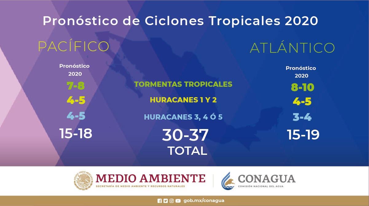
The Servicio de Meteorologia Nacional de Mexico issued their forecast 2 days ago

Image

TS: 15-19
H: 7-9
IH: 3-4

Source
3 likes   
Personal forecast disclaimer
This post is a personal point of view, not an information. Please refer to official statements for life-threatening decisions.

David '79, Frederic '79, Hugo '89, Iris, Luis & Marilyn '95, Georges '98, Lenny '99, Dean '07, Irma '17, Maria '17, Fiona '22, Philippe '23, Tammy '23
16°13'33.3,"6N -61°36'39.5"W

Shell Mound
Category 5
Category 5
Posts: 2434
Age: 31
Joined: Thu Sep 07, 2017 3:39 pm
Location: St. Petersburg, FL → Scandinavia

Re: Expert forecasts for 2020 North Atlantic Hurricane Season

#209 Postby Shell Mound » Tue May 26, 2020 5:58 am

Perhaps CSU will slightly reduce its numbers come June, owing to the recent, persistent cooling in the MDR/Caribbean (relative to earlier dates).
0 likes   
CVW / MiamiensisWx / Shell Mound
The posts in this forum are NOT official forecasts and should not be used as such. They are just the opinion of the poster and may or may not be backed by sound meteorological data. They are NOT endorsed by any professional institution or STORM2K. For official information, please refer to products from the NHC and NWS.

User avatar
JetFuel_SE
Category 1
Category 1
Posts: 263
Age: 24
Joined: Thu Apr 30, 2020 3:57 pm

Re: Expert forecasts for 2020 North Atlantic Hurricane Season

#210 Postby JetFuel_SE » Tue May 26, 2020 7:02 am

Shell Mound wrote:Perhaps CSU will slightly reduce its numbers come June, owing to the recent, persistent cooling in the MDR/Caribbean (relative to earlier dates).

Don't count on it, cooling at this time of the year is normal, and models are still predicting a warm MDR.
2 likes   

User avatar
cycloneye
Admin
Admin
Posts: 139042
Age: 67
Joined: Thu Oct 10, 2002 10:54 am
Location: San Juan, Puerto Rico

Re: Expert forecasts for 2020 North Atlantic Hurricane Season

#211 Postby cycloneye » Tue May 26, 2020 9:22 am

2 likes   
Visit the Caribbean-Central America Weather Thread where you can find at first post web cams,radars
and observations from Caribbean basin members Click Here

Florida1118
Category 5
Category 5
Posts: 1805
Age: 27
Joined: Sat Jun 19, 2010 12:57 pm
Location: Tampa, Florida

Re: Expert forecasts for 2020 North Atlantic Hurricane Season

#212 Postby Florida1118 » Tue May 26, 2020 10:30 am

[quote="cycloneye wrote:
[/quote]

Perhaps you know more about them, but how is this blog an “expert forecast”?
3 likes   

User avatar
CyclonicFury
Category 5
Category 5
Posts: 1971
Age: 25
Joined: Sun Jul 02, 2017 12:32 pm
Location: NC
Contact:

Re: Expert forecasts for 2020 North Atlantic Hurricane Season

#213 Postby CyclonicFury » Tue May 26, 2020 10:31 am

Florida1118 wrote:
[quote="cycloneye wrote:


Perhaps you know more about them, but how is this blog an “expert forecast”?[/quote]
I'm the author of said forecast. I am currently studying meteorology at NCSU, but do not consider myself an expert.
8 likes   
NCSU B.S. in Meteorology Class of 2021. Tropical weather blogger at http://www.cyclonicfury.com. My forecasts and thoughts are NOT official, for official forecasts please consult the National Hurricane Center.

Shell Mound
Category 5
Category 5
Posts: 2434
Age: 31
Joined: Thu Sep 07, 2017 3:39 pm
Location: St. Petersburg, FL → Scandinavia

Re: Expert forecasts for 2020 North Atlantic Hurricane Season

#214 Postby Shell Mound » Tue May 26, 2020 12:44 pm

CyclonicFury wrote:
Florida1118 wrote:
cycloneye wrote:


Perhaps you know more about them, but how is this blog an “expert forecast”?

I'm the author of said forecast. I am currently studying meteorology at NCSU, but do not consider myself an expert.

CyclonicFury, why does your latest May outlook give more weight to the active African monsoon and ENSO than to the +NPMM and near-average MDR/Caribbean? The reason why my numbers have been so much lower is that I give more weight to the latter two factors than to the former two. I also consider the likelihood that the NAO will be positive during ASO, as the relatively reliable EC/UKMET models suggest, which would further elevate MSLP and increase VWS over the tropics, owing not just to the enhanced African easterly jet, but also to the possibility of shear from convection over the EPAC.
0 likes   
CVW / MiamiensisWx / Shell Mound
The posts in this forum are NOT official forecasts and should not be used as such. They are just the opinion of the poster and may or may not be backed by sound meteorological data. They are NOT endorsed by any professional institution or STORM2K. For official information, please refer to products from the NHC and NWS.

User avatar
toad strangler
S2K Supporter
S2K Supporter
Posts: 4162
Joined: Sun Jul 28, 2013 3:09 pm
Location: Earth
Contact:

Re: Expert forecasts for 2020 North Atlantic Hurricane Season

#215 Postby toad strangler » Tue May 26, 2020 12:59 pm

Shell Mound wrote:
CyclonicFury wrote:
Florida1118 wrote:
Perhaps you know more about them, but how is this blog an “expert forecast”?

I'm the author of said forecast. I am currently studying meteorology at NCSU, but do not consider myself an expert.

CyclonicFury, why does your latest May outlook give more weight to the active African monsoon and ENSO than to the +NPMM and near-average MDR/Caribbean? The reason why my numbers have been so much lower is that I give more weight to the latter two factors than to the former two. I also consider the likelihood that the NAO will be positive during ASO, as the relatively reliable EC/UKMET models suggest, which would further elevate MSLP and increase VWS over the tropics, owing not just to the enhanced African easterly jet, but also to the possibility of shear from convection over the EPAC.


How is it that you have been tracking weather since one year before you were born is what I want to know :lol:
5 likes   

User avatar
CyclonicFury
Category 5
Category 5
Posts: 1971
Age: 25
Joined: Sun Jul 02, 2017 12:32 pm
Location: NC
Contact:

Re: Expert forecasts for 2020 North Atlantic Hurricane Season

#216 Postby CyclonicFury » Tue May 26, 2020 1:02 pm

Shell Mound wrote:
CyclonicFury wrote:
Florida1118 wrote:
Perhaps you know more about them, but how is this blog an “expert forecast”?

I'm the author of said forecast. I am currently studying meteorology at NCSU, but do not consider myself an expert.

CyclonicFury, why does your latest May outlook give more weight to the active African monsoon and ENSO than to the +NPMM and near-average MDR/Caribbean? The reason why my numbers have been so much lower is that I give more weight to the latter two factors than to the former two. I also consider the likelihood that the NAO will be positive during ASO, as the relatively reliable EC/UKMET models suggest, which would further elevate MSLP and increase VWS over the tropics, owing not just to the enhanced African easterly jet, but also to the possibility of shear from convection over the EPAC.

My forecast isn't much different, and is even lower than, some expert groups. Considering ENSO is cooler than the last two years, and the MDR is warmer than 2018/19, I am predicting a slightly more active season than 2018 or 2019.
I am just not convinced we will see near-below average activity with a near-ideal ENSO state, an MDR that is near to slightly above normal, and a strong WAM. Some seasons during the last inactive era, such as 1985 with an even colder MDR ended up more active than your 12-4-2 prediction. 2015, a Super El Niño year, was 11-4-2! To be fair you are more bearish than every expert out there. I could be wrong, but I disagree with your claims that the U.S. is probably at low risk simply because Arthur did not make landfall. Just because the MDR isn't as warm as 2005, 2010 or 2017 does not mean the MDR will be dead or the U.S. will be free from CV threats. Hurricanes such as Gloria, Andrew and Florence proved such.
10 likes   
NCSU B.S. in Meteorology Class of 2021. Tropical weather blogger at http://www.cyclonicfury.com. My forecasts and thoughts are NOT official, for official forecasts please consult the National Hurricane Center.

User avatar
cycloneye
Admin
Admin
Posts: 139042
Age: 67
Joined: Thu Oct 10, 2002 10:54 am
Location: San Juan, Puerto Rico

Re: Expert forecasts for 2020 North Atlantic Hurricane Season

#217 Postby cycloneye » Tue May 26, 2020 1:04 pm

Florida1118 wrote:
[quote="cycloneye wrote:


Perhaps you know more about them, but how is this blog an “expert forecast”?[/quote]

I only put his forecast in the thread but not on the list of the first page of experts.
2 likes   
Visit the Caribbean-Central America Weather Thread where you can find at first post web cams,radars
and observations from Caribbean basin members Click Here

User avatar
cycloneye
Admin
Admin
Posts: 139042
Age: 67
Joined: Thu Oct 10, 2002 10:54 am
Location: San Juan, Puerto Rico

Re: Expert forecasts for 2020 North Atlantic Hurricane Season: TSR raises numbers to 17/8/3

#218 Postby cycloneye » Thu May 28, 2020 9:29 am

TSR goes slightly up to 17/8/3 with ACE of 135 from the April 15/7/3 numbers. Waiting for the PDF form to add it on the list.

Image
3 likes   
Visit the Caribbean-Central America Weather Thread where you can find at first post web cams,radars
and observations from Caribbean basin members Click Here

User avatar
cycloneye
Admin
Admin
Posts: 139042
Age: 67
Joined: Thu Oct 10, 2002 10:54 am
Location: San Juan, Puerto Rico

Re: Expert forecasts for 2020 North Atlantic Hurricane Season: CSU updated forecast up at 11 AM EDT

#219 Postby cycloneye » Thu Jun 04, 2020 7:21 am

Let's see if Phil Klotzbach leave the numbers 16/8/4 or goes up a little.
0 likes   
Visit the Caribbean-Central America Weather Thread where you can find at first post web cams,radars
and observations from Caribbean basin members Click Here

User avatar
SFLcane
S2K Supporter
S2K Supporter
Posts: 9606
Age: 46
Joined: Sat Jun 05, 2010 1:44 pm
Location: Lake Worth Florida

Re: Expert forecasts for 2020 North Atlantic Hurricane Season: CSU updated forecast up at 11 AM EDT

#220 Postby SFLcane » Thu Jun 04, 2020 10:04 am

Wow! Phil goes with 19/9/4

Buckle up folks! :eek:
0 likes   


Return to “Talkin' Tropics”

Who is online

Users browsing this forum: Google [Bot], NotSparta and 78 guests