Texas Spring 2020
Moderator: S2k Moderators
Forum rules

The posts in this forum are NOT official forecast and should not be used as such. They are just the opinion of the poster and may or may not be backed by sound meteorological data. They are NOT endorsed by any professional institution or STORM2K.
-
bubba hotep

- S2K Supporter

- Posts: 5453
- Joined: Wed Dec 28, 2016 1:00 am
- Location: Collin County Texas
Re: Texas Spring 2020
From FWD twitter
0 likes
Winter time post are almost exclusively focused on the DFW area.
-
HockeyTx82
- S2K Supporter
- Posts: 1982
- Joined: Tue Oct 27, 2009 11:17 am
- Location: Ponder, TX
Re: Texas Spring 2020
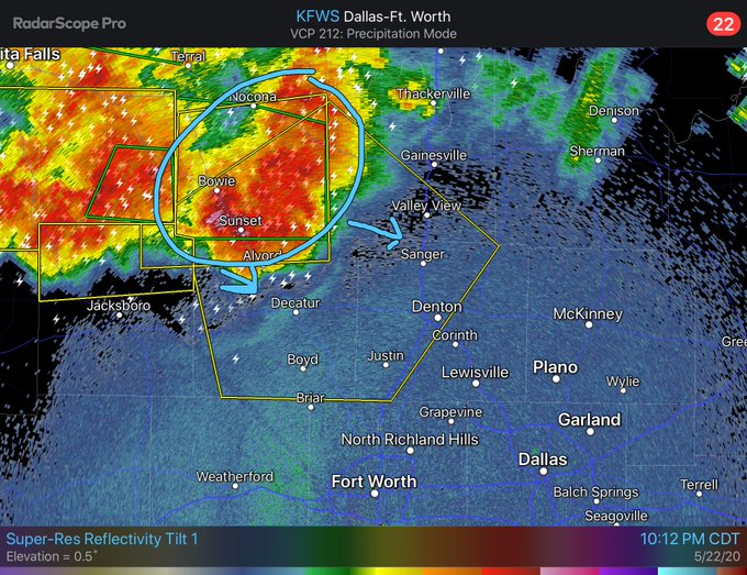
Do I see a gust front on NWS radar going SE out of that main cell heading towards Denton?
Could that weaken the storm a bit?
And keep that "hail" up north. Yikes, hope no one was killed.
Could that weaken the storm a bit?
And keep that "hail" up north. Yikes, hope no one was killed.
0 likes
Don't hold me accountable for anything I post on this forum. Leave the real forecasting up to the professionals.
Location: Ponder, TX (all observation posts are this location unless otherwise noted)
Location: Ponder, TX (all observation posts are this location unless otherwise noted)

Re: Texas Spring 2020
I don’t think I’ve ever seen hail that big. That’ll break every sunroof in existence. 
Also some strong winds and lots of lightning on that storm moving into Denton County! A couple hail cores but it looks like it’s weakening as it moves southeast, so hopefully the hail core will dissipate or weaken before going over heavily populated areas.
Also some strong winds and lots of lightning on that storm moving into Denton County! A couple hail cores but it looks like it’s weakening as it moves southeast, so hopefully the hail core will dissipate or weaken before going over heavily populated areas.
1 likes
Undergraduate Meteorology Student at the University of Oklahoma and Operator at the Oklahoma Mesonet.
All opinions independent of employers and the university.
All opinions independent of employers and the university.
-
Yukon Cornelius
- S2K Supporter
- Posts: 1737
- Age: 40
- Joined: Thu Dec 20, 2012 9:23 pm
- Location: Dean, TX/Westcliffe, CO
Re: Texas Spring 2020
Cerlin wrote:I don’t think I’ve ever seen hail that big. That’ll break every sunroof in existence.
Also some strong winds and lots of lightning on that storm moving into Denton County! A couple hail cores but it looks like it’s weakening as it moves southeast, so hopefully the hail core will dissipate or weaken before going over heavily populated areas.
It went straight through their roof.

Last edited by Yukon Cornelius on Fri May 22, 2020 10:46 pm, edited 1 time in total.
1 likes
#neversummer
-
bubba hotep
- S2K Supporter
- Posts: 5453
- Joined: Wed Dec 28, 2016 1:00 am
- Location: Collin County Texas
Re: Texas Spring 2020
Supposedly from that same storm

1 likes
Winter time post are almost exclusively focused on the DFW area.
-
rwfromkansas
- Category 5

- Posts: 2160
- Joined: Sat Aug 27, 2005 12:47 am
- Location: North Fort Worth
Re: Texas Spring 2020
There have been cases of terrifyingly large hail, and that qualifies. That would flat kill anybody outside and possibly even inside if standing in the wrong spot. I grouse at DFW using the outdoor warning sirens for not just tornadoes (growing up in KS, they were only for tornadoes, nothing else, so it was a weird adjustment here). But, for hail that big, blare the sirens. It's warranted for monster hail like that. Wow.
1 likes
-
HockeyTx82
- S2K Supporter
- Posts: 1982
- Joined: Tue Oct 27, 2009 11:17 am
- Location: Ponder, TX
Re: Texas Spring 2020
bubba hotep wrote:Supposedly from that same storm
https://pbs.twimg.com/media/EYrBHFsXYAEA1cA?format=jpg&name=large
Ok. So are we sure about that? I see quite a bit of daylight in that hole and no water damage. If that was from that hail then how about no thank you.
Last edited by HockeyTx82 on Fri May 22, 2020 10:56 pm, edited 1 time in total.
0 likes
Don't hold me accountable for anything I post on this forum. Leave the real forecasting up to the professionals.
Location: Ponder, TX (all observation posts are this location unless otherwise noted)
Location: Ponder, TX (all observation posts are this location unless otherwise noted)
-
HockeyTx82
- S2K Supporter
- Posts: 1982
- Joined: Tue Oct 27, 2009 11:17 am
- Location: Ponder, TX
Re: Texas Spring 2020
rwfromkansas wrote:There have been cases of terrifyingly large hail, and that qualifies. That would flat kill anybody outside and possibly even inside if standing in the wrong spot. I grouse at DFW using the outdoor warning sirens for not just tornadoes (growing up in KS, they were only for tornadoes, nothing else, so it was a weird adjustment here). But, for hail that big, blare the sirens. It's warranted for monster hail like that. Wow.
When we shelter we always grab out bike helmets to help protect our heads from the chance of hail or wind damage. It's something you can easily do. Football and hockey helmets work well too. No need to hold something over your head so you can better brace and hold onto pillows and family. With two little ones it's important we comfort and protect them.
1 likes
Don't hold me accountable for anything I post on this forum. Leave the real forecasting up to the professionals.
Location: Ponder, TX (all observation posts are this location unless otherwise noted)
Location: Ponder, TX (all observation posts are this location unless otherwise noted)
-
rwfromkansas
- Category 5
- Posts: 2160
- Joined: Sat Aug 27, 2005 12:47 am
- Location: North Fort Worth
Re: Texas Spring 2020
Good idea. We will do that from now on because you never know. Without basements here, I always feel a bit more like a sitting duck. Lol.
I am REALLY glad that storm didn't develop over DFW and give us that hail. Hope it was in a rural area.
I am REALLY glad that storm didn't develop over DFW and give us that hail. Hope it was in a rural area.
HockeyTx82 wrote:rwfromkansas wrote:There have been cases of terrifyingly large hail, and that qualifies. That would flat kill anybody outside and possibly even inside if standing in the wrong spot. I grouse at DFW using the outdoor warning sirens for not just tornadoes (growing up in KS, they were only for tornadoes, nothing else, so it was a weird adjustment here). But, for hail that big, blare the sirens. It's warranted for monster hail like that. Wow.
When we shelter we always grab out bike helmets to help protect our heads from the chance of hail or wind damage. It's something you can easily do. Football and hockey helmets work well too. No need to hold something over your head so you can better brace and hold onto pillows and family.
0 likes
-
cheezyWXguy

- Category 5
- Posts: 5528
- Joined: Mon Feb 13, 2006 12:29 am
- Location: Dallas, TX
Re: Texas Spring 2020
Even if these storms fall apart by the time they reach dfw, the evolution of these storms was much better reflected up to this point by the NAM than the HRRR
1 likes
-
HockeyTx82
- S2K Supporter
- Posts: 1982
- Joined: Tue Oct 27, 2009 11:17 am
- Location: Ponder, TX
Re: Texas Spring 2020
Wind just picked up here in Ponder. That outflow just past, temp dropped 5 degrees
1 likes
Don't hold me accountable for anything I post on this forum. Leave the real forecasting up to the professionals.
Location: Ponder, TX (all observation posts are this location unless otherwise noted)
Location: Ponder, TX (all observation posts are this location unless otherwise noted)
-
rwfromkansas
- Category 5
- Posts: 2160
- Joined: Sat Aug 27, 2005 12:47 am
- Location: North Fort Worth
-
Captmorg70
- Tropical Storm

- Posts: 178
- Age: 36
- Joined: Mon Dec 18, 2017 12:07 am
- Location: Ponder Tx
Re: Texas Spring 2020
Really big wind here in Ponder now. Had to reinforce the back door because afraid wind would blow open French doors
0 likes
-
HockeyTx82
- S2K Supporter
- Posts: 1982
- Joined: Tue Oct 27, 2009 11:17 am
- Location: Ponder, TX
Re: Texas Spring 2020
Captmorg70 wrote:Really big wind here in Ponder now. Had to reinforce the back door because afraid wind would blow open French doors
Yup, it's rocking and rolling here in Ponder. Our one stoplight is swaying in the wind.
3 likes
Don't hold me accountable for anything I post on this forum. Leave the real forecasting up to the professionals.
Location: Ponder, TX (all observation posts are this location unless otherwise noted)
Location: Ponder, TX (all observation posts are this location unless otherwise noted)
-
cheezyWXguy
- Category 5
- Posts: 5528
- Joined: Mon Feb 13, 2006 12:29 am
- Location: Dallas, TX
-
Brent
- S2K Supporter
- Posts: 37086
- Age: 35
- Joined: Sun May 16, 2004 10:30 pm
- Location: Tulsa Oklahoma
- Contact:
Re: Texas Spring 2020
cheezyWXguy wrote:Welp I think it’s pretty clear the NAM won tonight
definitely.The HRRR was out to lunch on this one
Meanwhile
 and theres still rain around at the end of the run!
2 likes
#neversummer
-
Yukon Cornelius
- S2K Supporter
- Posts: 1737
- Age: 40
- Joined: Thu Dec 20, 2012 9:23 pm
- Location: Dean, TX/Westcliffe, CO
Re: Texas Spring 2020
HockeyTx82 wrote:bubba hotep wrote:Supposedly from that same storm
https://pbs.twimg.com/media/EYrBHFsXYAEA1cA?format=jpg&name=large
Ok. So are we sure about that? I see quite a bit of daylight in that hole and no water damage. If that was from that hail then how about no thank you.
It’s on all of the local weather pages and quite a few people know the person and says it’s true.
1 likes
#neversummer
-
jasons2k

- Storm2k Executive

- Posts: 8071
- Age: 50
- Joined: Wed Jul 06, 2005 12:32 pm
- Location: The Woodlands, TX
Re: Texas Spring 2020
Update from Jeff Lindner:
Stormy weather pattern will begin over the weekend and last into much of next week.
Complexes of thunderstorms that form over north and west TX each afternoon have moved toward SE TX each night, but fallen apart before reaching the area. Seabreeze front and outflow boundaries from the north were able to overcome the cap across the northern portions of the area yesterday afternoon and resulted in the formation of a couple of strong thunderstorms. Today will be similar to yesterday with the chance of a few strong thunderstorms mainly in the College Station to Lake Livingston region.
An upper level trough will advance into TX on Sunday and this will likely result in some sort of complex of weather moving into the area Sunday afternoon and evening. Not sure exactly how this will play out, but parameters will be in place on Sunday afternoon and evening for a complex of storms to approach from the W or WNW and move slowly across the region. There will be some severe threat and a heavy rainfall threat with this complex. Short range models are really hitting the US 59 corridor from Wharton to Houston for some heavy rainfall, but I don’t have much faith in any of the solutions at the moment.
Upper level trough cuts off into an upper level low over TX on Monday and this feature meanders around the state for much of the week. Rain chances will remain high each day, although it will likely not be significant impacts each day. Each days forecast will be driven somewhat by the activity from the day before. So Monday will depend and where and how significant the activity is Sunday afternoon and evening. Parameters will continue to be in place for heavy rainfall and over time grounds will begin to saturate leading to increasing run-off and rises on area watersheds, especially rivers due to the widespread nature of the rainfall.
Rainfall amounts of 1-3 inches can be expected through early next week with isolated totals of 4-5 inches. Totals could be higher should storms slow or train over any area for an extended period of time. This is certainly the type of pattern where significant rains can occur.
Jeff Lindner
1 likes
-
bubba hotep
- S2K Supporter
- Posts: 5453
- Joined: Wed Dec 28, 2016 1:00 am
- Location: Collin County Texas
Re: Texas Spring 2020
From the FWD AFD:
By Sunday, nearly continuous troughing will connect a mid-latitude
longwave emerging from the Rockies to a relative weakness in the
Gulf. This will result in a steady transition to a tropical,
moist-adiabatic profile above North and Central Texas. While this
will reduce the severe potential, persistent lift will maintain
widespread showers and embedded thunderstorms throughout Sunday
and Monday. Extraordinary precipitation efficiency through this
protracted rain event could mean considerable flooding by Memorial
Day, both short-scale flashing flooding and more prolonged
flooding of our near-capacity river/reservoir systems.
2 likes
Winter time post are almost exclusively focused on the DFW area.
Return to “USA & Caribbean Weather”
Who is online
Users browsing this forum: 869MB and 40 guests