https://twitter.com/philklotzbach/status/1272669533195517953
ENSO Updates (2007 thru 2023)
Moderator: S2k Moderators
Forum rules

The posts in this forum are NOT official forecasts and should not be used as such. They are just the opinion of the poster and may or may not be backed by sound meteorological data. They are NOT endorsed by any professional institution or STORM2K. For official information, please refer to products from the National Hurricane Center and National Weather Service.
-
cycloneye

- Admin

- Posts: 139027
- Age: 67
- Joined: Thu Oct 10, 2002 10:54 am
- Location: San Juan, Puerto Rico
Re: ENSO: CPC Weekly update: Niño 3.4 down to -0.6C
3 likes
Visit the Caribbean-Central America Weather Thread where you can find at first post web cams,radars
and observations from Caribbean basin members Click Here
and observations from Caribbean basin members Click Here
-
WeatherEmperor
- S2K Supporter

- Posts: 4806
- Age: 40
- Joined: Thu Sep 04, 2003 2:54 pm
- Location: South Florida
Re: ENSO: CPC Weekly update: Niño 3.4 down to -0.6C
Are there any indicators that any of the Nino regions could warm up again? Any WWB's in the near future?
Sent from my iPhone using Tapatalk
Sent from my iPhone using Tapatalk
1 likes
-
JetFuel_SE

- Category 1

- Posts: 262
- Age: 24
- Joined: Thu Apr 30, 2020 3:57 pm
Re: ENSO: CPC Weekly update: Niño 3.4 down to -0.6C
WeatherEmperor wrote:Are there any indicators that any of the Nino regions could warm up again? Any WWB's in the near future?
Sent from my iPhone using Tapatalk
Sadly, no.
2 likes
-
TeamPlayersBlue

- Category 5

- Posts: 3307
- Joined: Tue Feb 02, 2010 1:44 am
- Location: Denver/Applewood, CO
Re: ENSO Updates
Which is the chicken and which is the egg when it comes to ENSO and AAM? Thanks for all the educational info in this thread!
0 likes
Personal Forecast Disclaimer:
The posts in this forum are NOT official forecast and should not be used as such. They are just the opinion of the poster and may or may not be backed by sound meteorological data. They are NOT endorsed by any professional institution or storm2k.org. For official information, please refer to the NHC and NWS products.
The posts in this forum are NOT official forecast and should not be used as such. They are just the opinion of the poster and may or may not be backed by sound meteorological data. They are NOT endorsed by any professional institution or storm2k.org. For official information, please refer to the NHC and NWS products.
-
Kingarabian

- S2K Supporter
- Posts: 15433
- Joined: Sat Aug 08, 2009 3:06 am
- Location: Honolulu, Hawaii
Re: ENSO Updates
TeamPlayersBlue wrote:Which is the chicken and which is the egg when it comes to ENSO and AAM? Thanks for all the educational info in this thread!
No one knows to be honest
4 likes
RIP Kobe Bryant
-
toad strangler

- S2K Supporter
- Posts: 4162
- Joined: Sun Jul 28, 2013 3:09 pm
- Location: Earth
- Contact:
-
StruThiO

- Category 3

- Posts: 821
- Age: 24
- Joined: Fri Sep 15, 2017 5:51 am
- Location: Currently Portland, OR. Raised in Jax, FL.
Re: ENSO Updates
PDO value last month was +0.09, the lowest May value since 2013. And the stretch of lowest PDO monthlies since before the +PDO flip continues.
0 likes
-
CyclonicFury

- Category 5
- Posts: 1971
- Age: 25
- Joined: Sun Jul 02, 2017 12:32 pm
- Location: NC
- Contact:
Re: ENSO Updates
Interestingly, the SOI has not yet responded to the -ENSO transition. The 30-day average SOI is -6.66, and the 90-day average SOI is -3.
3 likes
NCSU B.S. in Meteorology Class of 2021. Tropical weather blogger at http://www.cyclonicfury.com. My forecasts and thoughts are NOT official, for official forecasts please consult the National Hurricane Center.
-
toad strangler
- S2K Supporter
- Posts: 4162
- Joined: Sun Jul 28, 2013 3:09 pm
- Location: Earth
- Contact:
-
Shell Mound
- Category 5
- Posts: 2434
- Age: 31
- Joined: Thu Sep 07, 2017 3:39 pm
- Location: St. Petersburg, FL → Scandinavia
Re: ENSO Updates
CyclonicFury wrote:Interestingly, the SOI has not yet responded to the -ENSO transition. The 30-day average SOI is -6.66, and the 90-day average SOI is -3.
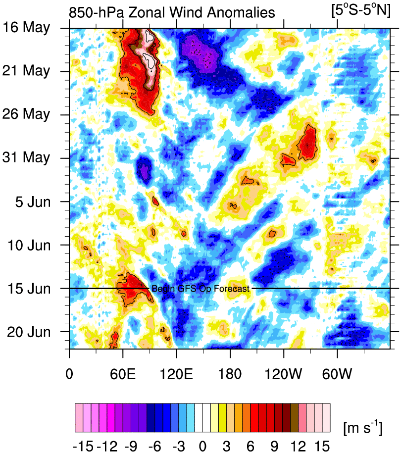
On another note, what do you think about the fact that June dynamical models have backed away from a moderate/strong -IOD? This would imply less +VP over the Maritime Continent by ASO and thus less of a positive signal for hyperactivity in the Atlantic, given that mean forcing would be concentrated more over the Indian Ocean than the MC. This kind of pattern would also imply more sinking air over the MDR/eastern Caribbean, especially during July and the first half of August, before Niña-type background state “kicks in” by the end of the month and later. For example, despite showing a stronger Niña vs. its May run, the June NMME has made a decent shift toward a weaker -PDO/stronger +PMM. This could imply stronger VWS over the Caribbean/MDR as well as periods of sinking air, especially given the notable trend toward a weaker -IOD signature. Also, the cold pool in the Gulf of Guinea is less pronounced in the latest NMME run, meaning more of a cap on strong African waves. All these indicators suggest less of a Niña-type atmospheric regime over the Caribbean/MDR than previously forecast, which is interesting in light of the fact that the latest run shows a stronger Pacific Niña along the equator.
1 likes
CVW / MiamiensisWx / Shell Mound
The posts in this forum are NOT official forecasts and should not be used as such. They are just the opinion of the poster and may or may not be backed by sound meteorological data. They are NOT endorsed by any professional institution or STORM2K. For official information, please refer to products from the NHC and NWS.
-
Kingarabian
- S2K Supporter
- Posts: 15433
- Joined: Sat Aug 08, 2009 3:06 am
- Location: Honolulu, Hawaii
Re: ENSO Updates
CyclonicFury wrote:Interestingly, the SOI has not yet responded to the -ENSO transition. The 30-day average SOI is -6.66, and the 90-day average SOI is -3.
Not surprising when you look at the current and near future -VP200 anomaly configuration. This continues the notion that this event will be a gradual one, similar to 2017s. June 2017 had a -SOI as well.
2 likes
RIP Kobe Bryant
-
Kingarabian
- S2K Supporter
- Posts: 15433
- Joined: Sat Aug 08, 2009 3:06 am
- Location: Honolulu, Hawaii
Re: ENSO Updates
The effects of volcanic eruption on ENSO. Seen this question on here before and there's been some published research:
https://www.hawaii.edu/news/2020/06/19/volcano-el-nino/
https://www.hawaii.edu/news/2020/06/19/volcano-el-nino/
3 likes
RIP Kobe Bryant
-
cycloneye
- Admin
- Posts: 139027
- Age: 67
- Joined: Thu Oct 10, 2002 10:54 am
- Location: San Juan, Puerto Rico
Re: ENSO Updates
The 30 day SOI keeps dipping now at -7.7. Are we sure is only a slow transition to La Niña or there is something more? I ask because is a big SOI drop and also the 4 Niño areas are going up. At this pace there will not be a weak La Niña for ASO.
From BoM:


From BoM:
Sustained negative values of the SOI below −7 typically indicate El Niño while sustained positive values above +7 typically indicate La Niña. Values between +7 and −7 generally indicate neutral conditions.
1 likes
Visit the Caribbean-Central America Weather Thread where you can find at first post web cams,radars
and observations from Caribbean basin members Click Here
and observations from Caribbean basin members Click Here
-
Kingarabian
- S2K Supporter
- Posts: 15433
- Joined: Sat Aug 08, 2009 3:06 am
- Location: Honolulu, Hawaii
Re: ENSO Updates
cycloneye wrote:The 30 day SOI keeps dipping now at -7.7. Are we sure is only a slow transition to La Niña or there is something more? I ask because is a big SOI drop and also the 4 Niño areas are going up. At this pace there will not be a weak La Niña for ASO.
From BoM:Sustained negative values of the SOI below −7 typically indicate El Niño while sustained positive values above +7 typically indicate La Niña. Values between +7 and −7 generally indicate neutral conditions.
[url]https://i.imgur.com/YmiO8V1.png[url]
[url]https://i.imgur.com/L9wwRPn.png[url]
[url]https://i.imgur.com/kngKXMQ.png[url]
[url]https://i.imgur.com/XLT383F.png[url]
[url]https://i.imgur.com/HEl9qw2.png[url]
This was never going to be a 2010-esque event where everything snowballs into La Nina. It's a slow process. Fluctuations are normal. It's normal for the SOI to be occasionally negative during the early stages of a weak La Nina event (see 2017).
2 likes
RIP Kobe Bryant
Re: ENSO Updates
cycloneye wrote:The 30 day SOI keeps dipping now at -7.7. Are we sure is only a slow transition to La Niña or there is something more? I ask because is a big SOI drop and also the 4 Niño areas are going up. At this pace there will not be a weak La Niña for ASO.
From BoM:Sustained negative values of the SOI below −7 typically indicate El Niño while sustained positive values above +7 typically indicate La Niña. Values between +7 and −7 generally indicate neutral conditions.
https://i.imgur.com/YmiO8V1.png
https://i.imgur.com/L9wwRPn.png
https://i.imgur.com/kngKXMQ.png
https://i.imgur.com/XLT383F.png
https://i.imgur.com/HEl9qw2.png
Apart from maybe Nino 4, the overall trend still looks the right direction to me. Also if it just keeps fluctuating we could easily end up cool neutral.
The current SOI is rather interesting but my knowledge on that is limited.
0 likes
-
cycloneye
- Admin
- Posts: 139027
- Age: 67
- Joined: Thu Oct 10, 2002 10:54 am
- Location: San Juan, Puerto Rico
Re: ENSO Updates
30 day SOI latest is sinking from -7.7 to -9.1.

2 likes
Visit the Caribbean-Central America Weather Thread where you can find at first post web cams,radars
and observations from Caribbean basin members Click Here
and observations from Caribbean basin members Click Here

Re: ENSO Updates
Dumb question, but what is SOI and what does it mean in the context of Atlantic hurricane season activity?
0 likes
Irene '11 Sandy '12 Hermine '16 5/15/2018 Derecho Fay '20 Isaias '20 Elsa '21 Henri '21 Ida '21
I am only a meteorology enthusiast who knows a decent amount about tropical cyclones. Look to the professional mets, the NHC, or your local weather office for the best information.
I am only a meteorology enthusiast who knows a decent amount about tropical cyclones. Look to the professional mets, the NHC, or your local weather office for the best information.
-
Kingarabian
- S2K Supporter
- Posts: 15433
- Joined: Sat Aug 08, 2009 3:06 am
- Location: Honolulu, Hawaii
Re: ENSO Updates
Its the difference of the pressure readings over Darwin Australia and Tahiti.aspen wrote:Dumb question, but what is SOI and what does it mean in the context of Atlantic hurricane season activity?
Not much effects on the Atlantic hurricane season. Maybe indirect effects? It has more effects on CONUS winter. A 90 day SOI +/- 8 means present El Nino or La Nina conditions. A 30 day SOI +/- 8 usually means a present active or in active intra-seasonal signal over the WPAC and Dateline (MJO/CCKW). However the 30 day SOI can be noisy and show illusions of an inactive or active phase.
3 likes
RIP Kobe Bryant
Re: ENSO Updates
Kingarabian wrote:Its the difference of the pressure readings over Darwin Australia and Tahiti.aspen wrote:Dumb question, but what is SOI and what does it mean in the context of Atlantic hurricane season activity?
Not much effects on the Atlantic hurricane season. Maybe indirect effects? It has more effects on CONUS winter. A 90 day SOI +/- 8 means present El Nino or La Nina conditions. A 30 day SOI +/- 8 usually means a present active or in active intra-seasonal signal over the WPAC and Dateline (MJO/CCKW). However the 30 day SOI can be noisy and show illusions of an inactive or active phase.
And this means the current value of -9.1 would be more indicative of El Nino then La Nina, which could raises some questions about the current ENSO forecast.
As for the Atlantic hurricane season, it is known that El Nino suppresses tc development.
https://www.climate.gov/news-features/b ... ane-season
1 likes
-
Kingarabian
- S2K Supporter
- Posts: 15433
- Joined: Sat Aug 08, 2009 3:06 am
- Location: Honolulu, Hawaii
Re: ENSO Updates
Visioen wrote:Kingarabian wrote:Its the difference of the pressure readings over Darwin Australia and Tahiti.aspen wrote:Dumb question, but what is SOI and what does it mean in the context of Atlantic hurricane season activity?
Not much effects on the Atlantic hurricane season. Maybe indirect effects? It has more effects on CONUS winter. A 90 day SOI +/- 8 means present El Nino or La Nina conditions. A 30 day SOI +/- 8 usually means a present active or in active intra-seasonal signal over the WPAC and Dateline (MJO/CCKW). However the 30 day SOI can be noisy and show illusions of an inactive or active phase.
And this means the current value of -9.1 would be more indicative of El Nino then La Nina, which could raises some questions about the current ENSO forecast.
As for the Atlantic hurricane season, it is known that El Nino suppresses tc development.
https://www.climate.gov/news-features/b ... ane-season
The present -9.1 value is the 30 day calculation. The 90 day SOI is the El Nino or La Nina indicator to monitor. Right now it's at a -3.34, or in neutral territory. It's been obvious that the atmosphere is lagging behind the ocean in terms of La Nina. But IMO it'll eventually get there. In regards to Atlantic hurricane development, the hardest hitting Atlantic hurricane seasons have generally been when ENSO was in a state of weak La Nina or cool neutral by ASO. Which is what's currently happening.
4 likes
RIP Kobe Bryant
Who is online
Users browsing this forum: Hurricane2022, tolakram and 151 guests