ATL: ISAIAS - Models
Moderator: S2k Moderators
-
SFLcane

- S2K Supporter

- Posts: 9606
- Age: 46
- Joined: Sat Jun 05, 2010 1:44 pm
- Location: Lake Worth Florida
Re: ATL: ISAIAS - Models
With a landfall as the 12z gfs suggests I just can’t see how palm beach and Broward county doesn’t see TS winds.
1 likes


-
CFLHurricane

- Category 1

- Posts: 312
- Joined: Thu Mar 27, 2014 5:56 pm
- Location: Floriduh
Re: ATL: ISAIAS - Models
If the Palm Bay/ Melbourne shield Can block Dorian and Matthew, it can certainly handle this chump of a storm.
1 likes
I'm not a meteorologist, but I did stay at a motel 8.

Re: ATL: ISAIAS - Models
Interesting how it deepens a little over Brevard country. From what I have seen on the shear maps, Central Florida might be a bit more favorable of an environment.
We are really splitting hairs right now. A little wobble either way can make a huge difference.
It is interesting that a few of the models showed the current collapse of convection followed by another burst later tonight.
0 likes
-
toad strangler

- S2K Supporter
- Posts: 4162
- Joined: Sun Jul 28, 2013 3:09 pm
- Location: Earth
- Contact:
Re: ATL: ISAIAS - Models
12z CMC brings this sloppy mess right into S FL where John Morales is planning a picnic.
6 likes
-
gatorcane

- S2K Supporter
- Posts: 23499
- Age: 46
- Joined: Sun Mar 13, 2005 3:54 pm
- Location: Boca Raton, FL
Re: ATL: ISAIAS - Models
SFLcane wrote:With a landfall as the 12z gfs suggests I just can’t see how palm beach and Broward county doesn’t see TS winds.
Notice how the GFS turns the storm WNW over the Gulf Stream later tonight between hours 12-18. Then at the last second turns NNW as it stair steps. I expect a
Last edited by gatorcane on Sat Aug 01, 2020 11:39 am, edited 1 time in total.
1 likes
-
Canelaw99

- S2K Supporter
- Posts: 2112
- Age: 47
- Joined: Tue Aug 31, 2004 8:27 am
- Location: Homestead, FL
Re: ATL: ISAIAS - Models
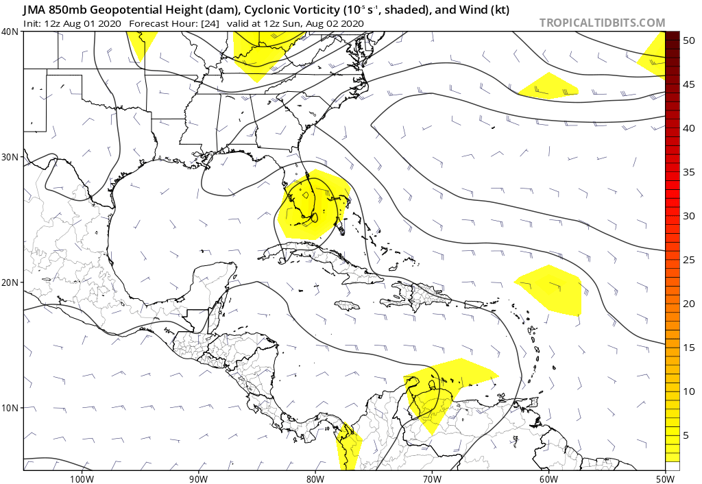
gatorcane wrote:JMA takes this to Miami before turning
Looking at the path it seems to be on now, this seems strangely plausible to me. Going to be an interesting day....
0 likes

Re: ATL: ISAIAS - Models
HWRF is more slower and a bit more south and west and intensifying over the Gulf Stream
0 likes
-
Blown Away

- S2K Supporter
- Posts: 9861
- Joined: Wed May 26, 2004 6:17 am
Re: ATL: ISAIAS - Models
Anyone have the 06z Euro?
0 likes
Hurricane Eye Experience: David 79, Irene 99, Frances 04, Jeanne 04, Wilma 05...
Hurricane Brush Experience: Andrew 92, Erin 95, Floyd 99, Matthew 16, Irma 17, Ian 22, Nicole 22…
Hurricane Brush Experience: Andrew 92, Erin 95, Floyd 99, Matthew 16, Irma 17, Ian 22, Nicole 22…
-
HurricaneEnzo

- Category 2

- Posts: 723
- Joined: Wed Mar 14, 2018 12:18 pm
- Location: Newport, NC (Hurricane Alley)
Re: RE: Re: ATL: ISAIAS - Models
Was about to say this. Not saying it will happen but wouldn't surprise me if it did at this point. Been moving far more West than North for a while. Still is showing no signs of an impending Northerly turn.Canelaw99 wrote:gatorcane wrote:JMA takes this to Miami before turning
Looking at the path it seems to be on now, this seems strangely plausible to me. Going to be an interesting day....
Sent from my SM-N975U using Tapatalk
2 likes
Bertha 96' - Fran 96' - Bonnie 98' - Dennis 99' - Floyd 99' - Isabel 03' - Alex 04' - Ophelia 05' - Irene 11' - Arthur 14' - Matthew 16' - Florence 18' - Dorian 19' - Isaias 20' (countless other tropical storms and Hurricane swipes)
I am not a Professional Met just an enthusiast. Get your weather forecasts from the Pros!
I am not a Professional Met just an enthusiast. Get your weather forecasts from the Pros!
-
gatorcane
- S2K Supporter
- Posts: 23499
- Age: 46
- Joined: Sun Mar 13, 2005 3:54 pm
- Location: Boca Raton, FL
Re: ATL: ISAIAS - Models
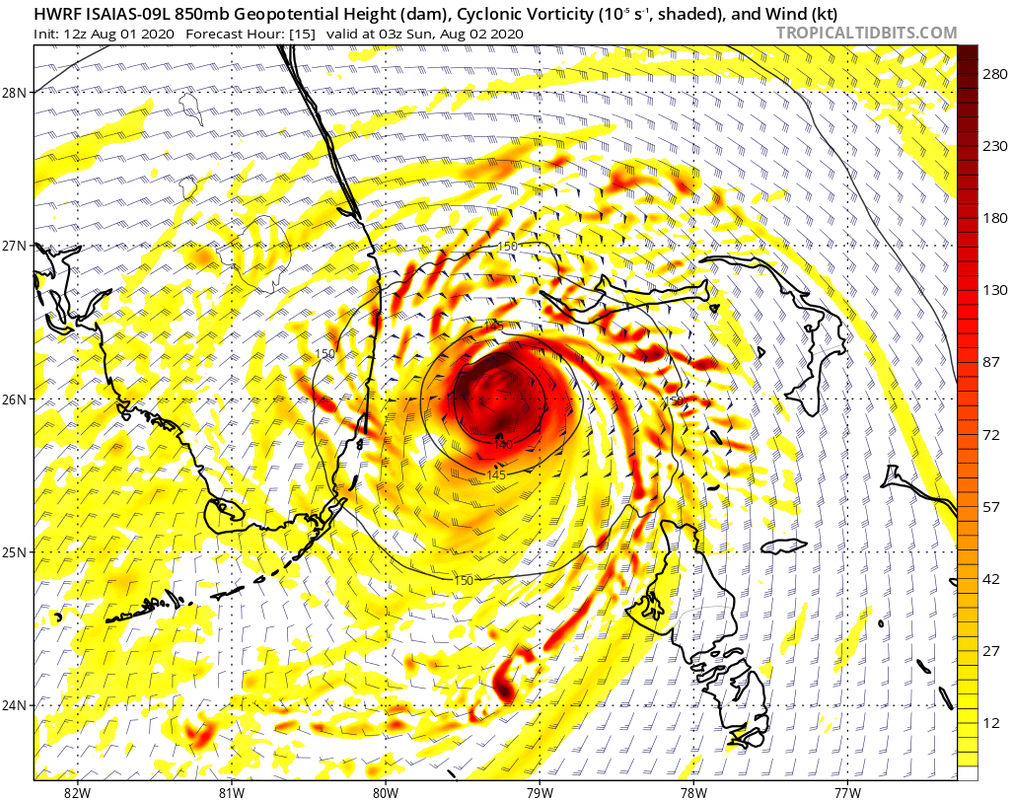
caneseddy wrote:HWRF is more slower and a bit more south and west and intensifying over the Gulf Stream
Big shift SW here (considering the timeframe) heading WNW:
Just like the GFS turns it WNW over the Gulf Steam albeit stair-stepping.
0 likes
Re: ATL: ISAIAS - Models
gatorcane wrote:Turns NNW at the last second:
https://i.postimg.cc/k4QrGQVB/hwrf-z850-vort-09-L-7.png
Looks like half/half landfall on the Space Coast
0 likes
-
gatorcane
- S2K Supporter
- Posts: 23499
- Age: 46
- Joined: Sun Mar 13, 2005 3:54 pm
- Location: Boca Raton, FL
Re: ATL: ISAIAS - Models
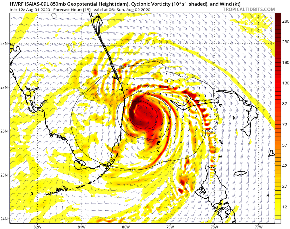
The HWRF is already a bit too far to the right looking at the storm which is moving more west near the western point of northern Abaco Island.
1 likes
-
toad strangler
- S2K Supporter
- Posts: 4162
- Joined: Sun Jul 28, 2013 3:09 pm
- Location: Earth
- Contact:
Re: ATL: ISAIAS - Models
12z HWRF starts moving inland right at my latitude in Port Saint Lucie and bounces on and off the coast from there north.
0 likes
-
Blown Away
- S2K Supporter
- Posts: 9861
- Joined: Wed May 26, 2004 6:17 am
Re: ATL: ISAIAS - Models
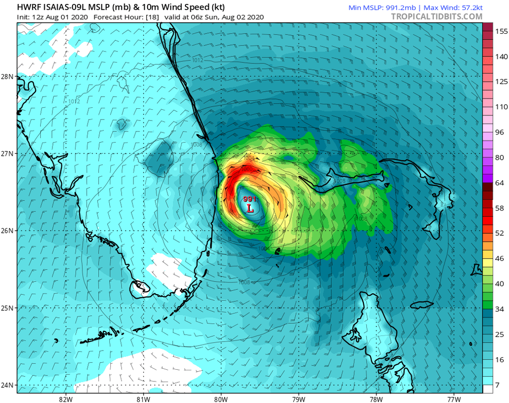
SFLcane wrote:Still big shift south HWRF...
Also shows a more moist environment than previous runs which may keep Isaias as a Hurricane.
1 likes
Hurricane Eye Experience: David 79, Irene 99, Frances 04, Jeanne 04, Wilma 05...
Hurricane Brush Experience: Andrew 92, Erin 95, Floyd 99, Matthew 16, Irma 17, Ian 22, Nicole 22…
Hurricane Brush Experience: Andrew 92, Erin 95, Floyd 99, Matthew 16, Irma 17, Ian 22, Nicole 22…
-
gatorcane
- S2K Supporter
- Posts: 23499
- Age: 46
- Joined: Sun Mar 13, 2005 3:54 pm
- Location: Boca Raton, FL
Re: ATL: ISAIAS - Models
Palm Beach / Broward County one unforeseen wobble from it landfalling or skimming coast:
2 likes
-
HurricaneEnzo
- Category 2
- Posts: 723
- Joined: Wed Mar 14, 2018 12:18 pm
- Location: Newport, NC (Hurricane Alley)
Re: ATL: ISAIAS - Models
HWRF has been pretty right biased so if its still the case this could potentially run through most of the peninsula. Probably low probability but you never know
Sent from my SM-N975U using Tapatalk
Sent from my SM-N975U using Tapatalk
Last edited by HurricaneEnzo on Sat Aug 01, 2020 11:54 am, edited 1 time in total.
1 likes
Bertha 96' - Fran 96' - Bonnie 98' - Dennis 99' - Floyd 99' - Isabel 03' - Alex 04' - Ophelia 05' - Irene 11' - Arthur 14' - Matthew 16' - Florence 18' - Dorian 19' - Isaias 20' (countless other tropical storms and Hurricane swipes)
I am not a Professional Met just an enthusiast. Get your weather forecasts from the Pros!
I am not a Professional Met just an enthusiast. Get your weather forecasts from the Pros!
Who is online
Users browsing this forum: No registered users and 70 guests