ATL: ISAIAS - Models
Moderator: S2k Moderators

Re: ATL: ISAIAS - Models
HMON stays offshore and doesn't appear to strengthen coming up to the Carolinas.
Last edited by Steve on Sat Aug 01, 2020 11:57 am, edited 1 time in total.
0 likes
-
toad strangler

- S2K Supporter

- Posts: 4162
- Joined: Sun Jul 28, 2013 3:09 pm
- Location: Earth
- Contact:
Re: ATL: ISAIAS - Models
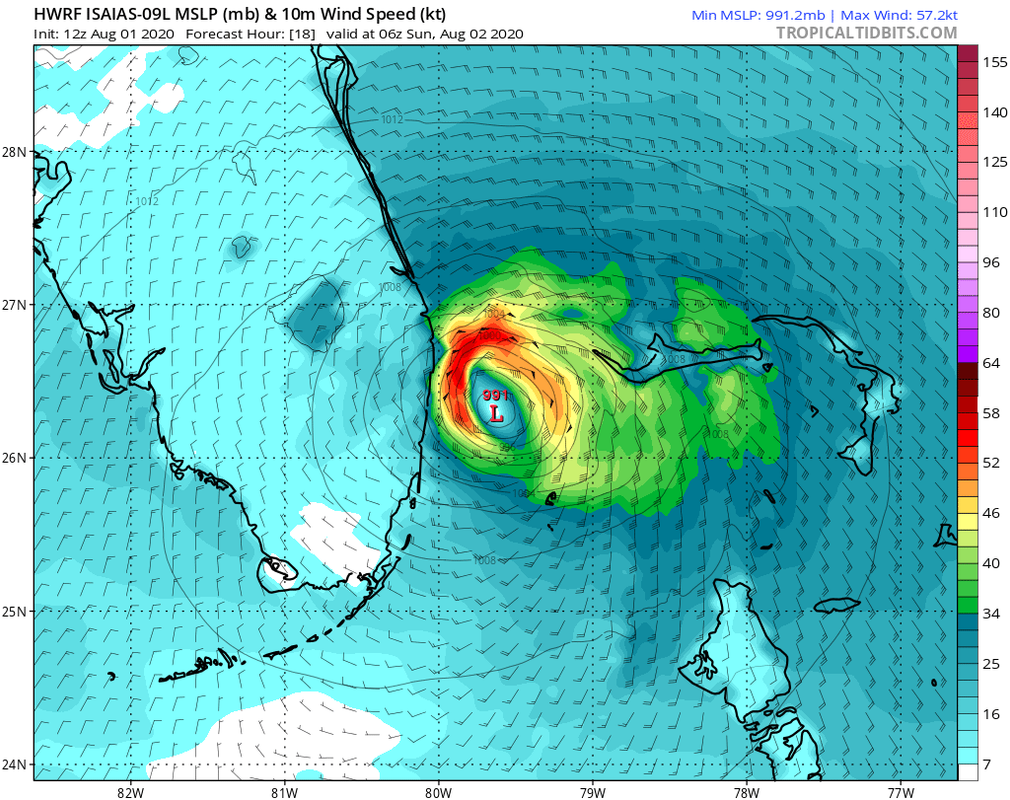
gatorcane wrote:Palm Beach / Broward County one unforeseen wobble from it landfalling or skimming coast:
https://i.postimg.cc/Px9Mg9fD/hwrf-mslp-wind-09-L-7.png
He might be weak, but he could be your landfall from the East
1 likes
-
HurricaneEnzo

- Category 2

- Posts: 723
- Joined: Wed Mar 14, 2018 12:18 pm
- Location: Newport, NC (Hurricane Alley)
Re: RE: Re: ATL: ISAIAS - Models
Just my personal opinion but I think this is still too far east. Gonna have a tough time getting there from its current position unless it changes its course really soon.gatorcane wrote:Palm Beach / Broward County one unforeseen wobble from it landfalling or skimming coast:
Sent from my SM-N975U using Tapatalk
0 likes
Bertha 96' - Fran 96' - Bonnie 98' - Dennis 99' - Floyd 99' - Isabel 03' - Alex 04' - Ophelia 05' - Irene 11' - Arthur 14' - Matthew 16' - Florence 18' - Dorian 19' - Isaias 20' (countless other tropical storms and Hurricane swipes)
I am not a Professional Met just an enthusiast. Get your weather forecasts from the Pros!
I am not a Professional Met just an enthusiast. Get your weather forecasts from the Pros!
Re: ATL: ISAIAS - Models
toad strangler wrote:gatorcane wrote:Palm Beach / Broward County one unforeseen wobble from it landfalling or skimming coast:
https://i.postimg.cc/Px9Mg9fD/hwrf-mslp-wind-09-L-7.png
He might be weak, but he could be your landfall from the East
lmao
Canadian still likes Miami. It's been too far west all along, but you never know until it happens.
https://www.tropicaltidbits.com/analysi ... 80112&fh=6
1 likes
Re: ATL: ISAIAS - Models
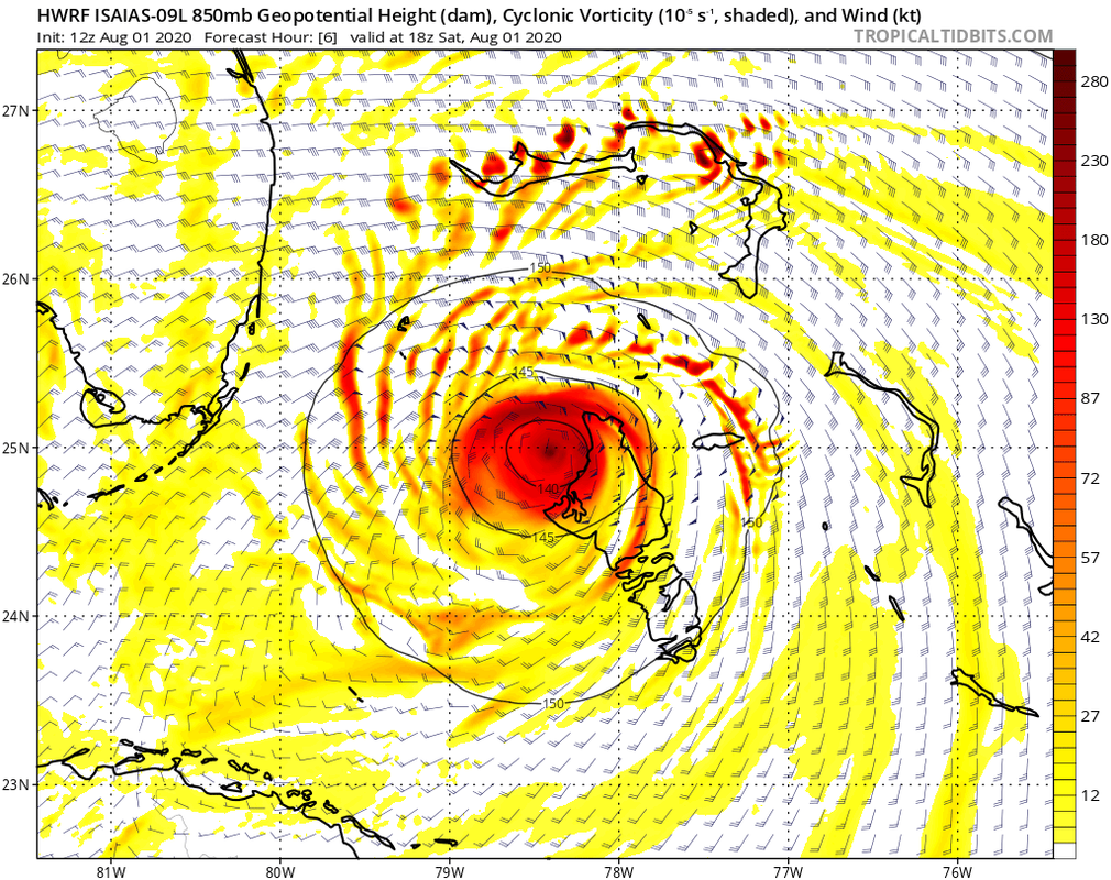
12z HWRF simulated IR looks to bring some nasty weather to the SEFL Coast on up towards the Space Coast
https://www.tropicaltidbits.com/analysi ... 80112&fh=9
https://www.tropicaltidbits.com/analysi ... 80112&fh=9
2 likes
-
SFLcane

- S2K Supporter
- Posts: 9606
- Age: 46
- Joined: Sat Jun 05, 2010 1:44 pm
- Location: Lake Worth Florida
Re: ATL: ISAIAS - Models
gatorcane wrote:Palm Beach / Broward County one unforeseen wobble from it landfalling or skimming coast:
https://i.postimg.cc/Px9Mg9fD/hwrf-mslp-wind-09-L-7.png
Wouldn’t that bring TS inland? Broward/PB
0 likes
-
SFLcane
- S2K Supporter
- Posts: 9606
- Age: 46
- Joined: Sat Jun 05, 2010 1:44 pm
- Location: Lake Worth Florida
Re: ATL: ISAIAS - Models
Eric Webb...
Worth noting that #Isaias will be ~ 100 km S-SW of the 6z HWRF & HMON 12hr forecast pts valid at 18z today. #Isaias weakening over Andros Isl. will have a big effect on impacts in the SE US. Expect a significant westward shift in upcoming computer model & official track forecasts.
https://twitter.com/webberweather/status/1289600962529759232
4 likes
-
gatorcane

- S2K Supporter
- Posts: 23499
- Age: 46
- Joined: Sun Mar 13, 2005 3:54 pm
- Location: Boca Raton, FL
Re: ATL: ISAIAS - Models
SFLcane wrote::eek:
Eric Webb...
Worth noting that #Isaias will be ~ 100 km S-SW of the 6z HWRF & HMON 12hr forecast pts valid at 18z today. #Isaias weakening over Andros Isl. will have a big effect on impacts in the SE US. Expect a significant westward shift in upcoming computer model & official track forecasts.
https://twitter.com/webberweather/statu ... 59232?s=21
12Z HWRF position in 6 hours. Don’t see it that far north. It would have to move north now.
0 likes
-
gatorcane
- S2K Supporter
- Posts: 23499
- Age: 46
- Joined: Sun Mar 13, 2005 3:54 pm
- Location: Boca Raton, FL
Re: ATL: ISAIAS - Models
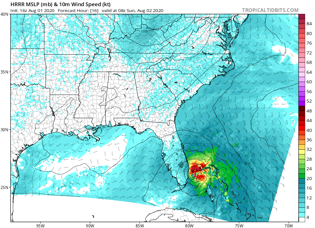
HRRR shifts west. Looks like sustained TS winds for coastal Broward/Palm Beach County:
1 likes
-
Weatherboy1

- Category 5

- Posts: 1167
- Age: 48
- Joined: Mon Jul 05, 2004 1:50 pm
- Location: Jupiter, FL
Re: ATL: ISAIAS - Models
jhpigott wrote:12z HWRF simulated IR looks to bring some nasty weather to the SEFL Coast on up towards the Space Coast
https://www.tropicaltidbits.com/analysi ... 80112&fh=9
That would be quite the “blow up” from what Isaias looks like now if it verified!
0 likes
-
jlauderdal
- S2K Supporter
- Posts: 6771
- Joined: Wed May 19, 2004 5:46 am
- Location: NE Fort Lauderdale
- Contact:
Re: RE: Re: ATL: ISAIAS - Models
Haha, it would be an epic fail if it landed more than 1mm S of Bocatoad strangler wrote:12z CMC brings this sloppy mess right into S FL where John Morales is planning a picnic.
1 likes
-
jlauderdal
- S2K Supporter
- Posts: 6771
- Joined: Wed May 19, 2004 5:46 am
- Location: NE Fort Lauderdale
- Contact:
Re: RE: Re: ATL: ISAIAS - Models
The hwrf is a model without a plan, all it does is oscillate on intensity and track each run keeping us all wondering that maybe its on to something..like a hack golfer that hits enough decent shots to keep coming backSFLcane wrote:Still big shift south HWRF...
1 likes
-
jlauderdal
- S2K Supporter
- Posts: 6771
- Joined: Wed May 19, 2004 5:46 am
- Location: NE Fort Lauderdale
- Contact:
Re: RE: Re: ATL: ISAIAS - Models
im getting in my car and driving the 10 miles N on A1A to see the hwrf verify, unlikelygatorcane wrote:Palm Beach / Broward County one unforeseen wobble from it landfalling or skimming coast:
1 likes
-
jlauderdal
- S2K Supporter
- Posts: 6771
- Joined: Wed May 19, 2004 5:46 am
- Location: NE Fort Lauderdale
- Contact:
Re: RE: Re: ATL: ISAIAS - Models
Yes, landfall deerfield beach/ boca lineSFLcane wrote:gatorcane wrote:Palm Beach / Broward County one unforeseen wobble from it landfalling or skimming coast:
https://i.postimg.cc/Px9Mg9fD/hwrf-mslp-wind-09-L-7.png
Wouldn’t that bring TS inland? Broward/PB
0 likes
-
CourierPR

- Category 5
- Posts: 1325
- Age: 70
- Joined: Tue Aug 31, 2004 7:53 pm
- Location: Pompano Beach, Florida
Re: ATL: ISAIAS - Models
Why the disparity between what we see on satellite and what has been forecast? This reminds me of Irene in '99 when it was supposed to pass south Florida in the Gulf but ended up going over my house in Pompano Beach.
1 likes
-
gatorcane
- S2K Supporter
- Posts: 23499
- Age: 46
- Joined: Sun Mar 13, 2005 3:54 pm
- Location: Boca Raton, FL
Re: ATL: ISAIAS - Models
Let’s face it. When the CMC is insisting only a weak to at most moderate TS as it moves into South Florida, we shouldn’t be surprised at what we are seeing, that model is very bullish normally and just hasn’t been for this storm.
5 likes
-
SFLcane
- S2K Supporter
- Posts: 9606
- Age: 46
- Joined: Sat Jun 05, 2010 1:44 pm
- Location: Lake Worth Florida
Re: ATL: ISAIAS - Models
gatorcane wrote:Let’s face it. When the CMC is insisting only a weak to at most moderate TS as it moves into South Florida, we shouldn’t be surprised at what we are seeing, that model is very bullish normally and just hasn’t been for this storm.
Quite curious to see the 12z Euro I bet it comes west.
0 likes

Re: ATL: ISAIAS - Models
SFLcane wrote:gatorcane wrote:Let’s face it. When the CMC is insisting only a weak to at most moderate TS as it moves into South Florida, we shouldn’t be surprised at what we are seeing, that model is very bullish normally and just hasn’t been for this storm.
Quite curious to see the 12z Euro I bet it comes west.
East
0 likes
-
MississippiWx

- S2K Supporter
- Posts: 1535
- Joined: Sat Aug 14, 2010 1:44 pm
- Location: Hattiesburg, Mississippi
Re: ATL: ISAIAS - Models
gatorcane wrote:Let’s face it. When the CMC is insisting only a weak to at most moderate TS as it moves into South Florida, we shouldn’t be surprised at what we are seeing, that model is very bullish normally and just hasn’t been for this storm.
The CMC hasn’t been “bullish” all season.
1 likes
This post is not an official forecast and should not be used as such. It is just the opinion of MississippiWx and may or may not be backed by sound meteorological data. It is not endorsed by any professional institution including storm2k.org. For Official Information please refer to the NHC and NWS products.
Who is online
Users browsing this forum: No registered users and 29 guests