ATL: PAULETTE - Models
Moderator: S2k Moderators
-
cycloneye

- Admin

- Posts: 139049
- Age: 67
- Joined: Thu Oct 10, 2002 10:54 am
- Location: San Juan, Puerto Rico
ATL: PAULETTE - Models
Only model runs.
0 likes
Visit the Caribbean-Central America Weather Thread where you can find at first post web cams,radars
and observations from Caribbean basin members Click Here
and observations from Caribbean basin members Click Here
-
CyclonicFury

- Category 5

- Posts: 1973
- Age: 25
- Joined: Sun Jul 02, 2017 12:32 pm
- Location: NC
- Contact:
Re: ATL: INVEST 92L - Models
Lots of shear according to SHIPS.
* GFS version *
* ATLANTIC 2020 SHIPS INTENSITY FORECAST *
* IR SAT DATA AVAILABLE, OHC AVAILABLE *
* INVEST AL922020 09/04/20 18 UTC *
TIME (HR) 0 6 12 18 24 36 48 60 72 84 96 108 120 132 144 156 168
V (KT) NO LAND 25 26 26 26 27 29 32 33 34 33 31 31 30 30 33 38 42
V (KT) LAND 25 26 26 26 27 29 32 33 34 33 31 31 30 30 33 38 42
V (KT) LGEM 25 25 26 26 27 27 26 25 23 20 18 17 15 N/A N/A N/A N/A
Storm Type TROP TROP TROP TROP TROP TROP TROP TROP TROP TROP TROP TROP TROP TROP TROP TROP TROP
SHEAR (KT) 15 6 8 12 18 22 28 35 35 34 34 32 26 21 12 14 16
SHEAR ADJ (KT) -1 2 5 6 3 2 1 -1 -4 -3 0 0 1 -1 -5 -1 0
SHEAR DIR 56 15 329 295 272 275 268 273 265 252 235 229 220 205 163 125 105
SST (C) 27.2 27.4 26.9 26.7 26.4 26.2 26.6 26.7 26.6 26.6 26.5 26.3 26.5 27.4 28.1 28.2 28.2
POT. INT. (KT) 128 131 125 123 120 117 120 121 119 120 119 118 119 128 135 135 135
ADJ. POT. INT. 126 129 123 121 116 111 111 112 109 111 111 110 112 120 123 122 122
200 MB T (C) -52.8 -52.9 -53.1 -53.2 -52.9 -53.3 -53.1 -53.3 -53.3 -53.7 -53.3 -53.3 -52.9 -53.2 -53.2 -52.9 -52.6
200 MB VXT (C) 0.2 0.3 0.0 0.0 0.0 0.0 0.0 0.0 0.0 0.0 0.0 0.0 0.0 0.0 0.0 0.0 0.0
TH_E DEV (C) 6 5 5 5 5 5 6 7 8 7 8 9 9 9 9 9 10
700-500 MB RH 71 70 68 66 64 60 57 54 52 53 51 48 42 45 45 48 48
MODEL VTX (KT) 11 10 LOST LOST LOST LOST LOST LOST LOST LOST LOST LOST LOST LOST LOST LOST LOST
850 MB ENV VOR 78 59 35 24 36 60 79 90 100 104 110 117 120 117 102 104 96
200 MB DIV 10 22 23 27 50 66 63 25 20 27 17 12 24 -1 2 5 13
700-850 TADV -12 -14 -12 8 9 2 0 -10 15 -2 4 -2 -3 -2 0 2 0
LAND (KM) 828 957 1119 1305 1478 1784 2047 2214 2087 1973 1845 1692 1501 1272 1138 1074 1079
LAT (DEG N) 15.2 16.3 17.1 17.9 18.6 19.3 19.7 19.6 19.7 19.8 19.8 19.4 18.6 xx.x xx.x xx.x xx.x
LONG(DEG W) 25.2 26.3 27.7 29.3 30.9 34.0 36.6 38.6 40.6 42.5 44.8 47.2 49.6 xxx.x xxx.x xxx.x xxx.x
STM SPEED (KT) 15 15 16 17 16 14 10 10 9 10 11 12 11 9 4 2 2
HEAT CONTENT 11 16 7 5 4 2 8 8 2 3 5 2 2 16 35 40 37
0 likes
NCSU B.S. in Meteorology Class of 2021. Tropical weather blogger at http://www.cyclonicfury.com. My forecasts and thoughts are NOT official, for official forecasts please consult the National Hurricane Center.
-
gatorcane

- S2K Supporter

- Posts: 23499
- Age: 46
- Joined: Sun Mar 13, 2005 3:54 pm
- Location: Boca Raton, FL
Re: ATL: INVEST 92L - Models
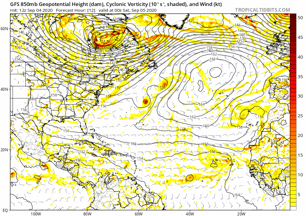
Like the GFS has done since the beginning with this, the 12z recurves into the north-Central Atlantic NE of the Lesser Antilles:
2 likes
-
SconnieCane
- Category 4

- Posts: 913
- Joined: Thu Aug 02, 2018 5:29 pm
- Location: Madison, WI
Re: ATL: INVEST 92L - Models
2 likes
-
gatorcane
- S2K Supporter
- Posts: 23499
- Age: 46
- Joined: Sun Mar 13, 2005 3:54 pm
- Location: Boca Raton, FL
Re: ATL: INVEST 92L - Models
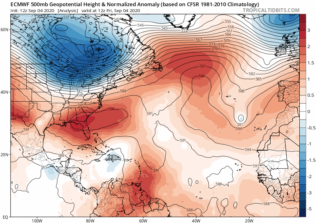
The Bermuda High is under siege on this run of the 12Z Euro. It is getting squashed by the cutoff low over the US and a mid-upper low over the Central Atlantic. The model consequently turns 92l north over the Central Atlantic just like the GFS. It also weakens it.
3 likes
-
Aric Dunn
- Category 5
- Posts: 21228
- Age: 41
- Joined: Sun Sep 19, 2004 9:58 pm
- Location: Ready for the Chase.
- Contact:
Re: ATL: INVEST 92L - Models
Models get rid of one interaction ( 91L) and introduce another..
the wave behind 92L catches up and then starts ineracting and that waves get thrown NW then 92L follows.
otherwise riding would keep 92L moving w to wnw.
the wave behind 92L catches up and then starts ineracting and that waves get thrown NW then 92L follows.
otherwise riding would keep 92L moving w to wnw.
2 likes
Note: If I make a post that is brief. Please refer back to previous posts for the analysis or reasoning. I do not re-write/qoute what my initial post said each time.
If there is nothing before... then just ask
Space & Atmospheric Physicist, Embry-Riddle Aeronautical University,
I believe the sky is falling...
If there is nothing before... then just ask
Space & Atmospheric Physicist, Embry-Riddle Aeronautical University,
I believe the sky is falling...

Re: ATL: INVEST 92L - Models
The CMC and ICON are having varying degrees of trouble with the interaction between 91L and 92L. They still think 91L is its own separate area of vorticity, but if Aric is right, it’s been completely strung out and should not induce a Fujiwhara-like rotation between the two invests. The ICON has 92L quickly becoming dominant, while the CMC shows them interacting too much for either to develop, which seems unrealistic given the state of 91L. The Euro’s relativity Fujiwhara-free genesis seems to be the most plausible scenario, depending on what happens to 92L’s two circulations.
3 likes
Irene '11 Sandy '12 Hermine '16 5/15/2018 Derecho Fay '20 Isaias '20 Elsa '21 Henri '21 Ida '21
I am only a meteorology enthusiast who knows a decent amount about tropical cyclones. Look to the professional mets, the NHC, or your local weather office for the best information.
I am only a meteorology enthusiast who knows a decent amount about tropical cyclones. Look to the professional mets, the NHC, or your local weather office for the best information.
-
Hypercane_Kyle

- Category 5
- Posts: 2899
- Joined: Sat Mar 07, 2015 7:58 pm
- Location: Cape Canaveral, FL
Re: ATL: INVEST 92L - Models
00z Euro coming in...
Ridging looks more stout through 144 hours.

Ridging looks more stout through 144 hours.
0 likes
My posts are my own personal opinion, defer to the National Hurricane Center (NHC) and other NOAA products for decision making during hurricane season.
-
Shell Mound
- Category 5
- Posts: 2434
- Age: 31
- Joined: Thu Sep 07, 2017 3:39 pm
- Location: St. Petersburg, FL → Scandinavia
Re: ATL: INVEST 92L - Models
A fairly consistent theme of the EPS guidance thus far: 92L is expected to become TS Paulette—whose name is redolent of EPAC systems—within the next day. On days two and three, most of the guidance shows a pronounced, persistent WSW motion, as shortwave ridging temporarily strengthens on the western flank of the TUTT. In three and a half days, steering currents break down as 92L/Paulette finds itself in the col region between the ridge and the TUTT. 92L’s future track depends on its intensity, its organisational depth, by then, which will dictate its long-term future. A weaker 92L in the short term would move more rapidly and be farther SW by then, whereas a deeper 92L would be slower and farther NE. Nevertheless, the EPS shows that even the weakest members eventually turn 92L northward well to the east of the Lesser Antilles, so OTS seems to be assured as an outcome, given the depth of the TUTT-induced weakness on the runs.
1 likes
CVW / MiamiensisWx / Shell Mound
The posts in this forum are NOT official forecasts and should not be used as such. They are just the opinion of the poster and may or may not be backed by sound meteorological data. They are NOT endorsed by any professional institution or STORM2K. For official information, please refer to products from the NHC and NWS.
Re: ATL: INVEST 92L - Models
It’s an outlier, but look how far west 92L is getting on 12Z GFS.
Edit: Is this the wave behind 92L?
Edit: Is this the wave behind 92L?
0 likes
Personal Forecast Disclaimer:
The posts in this forum are NOT official forecasts and should not be used as such. They are just the opinion of the poster and may or may not be backed by sound meteorological data. They are NOT endorsed by any professional institution or storm2k.org. For official information, please refer to the NHC and NWS products.
The posts in this forum are NOT official forecasts and should not be used as such. They are just the opinion of the poster and may or may not be backed by sound meteorological data. They are NOT endorsed by any professional institution or storm2k.org. For official information, please refer to the NHC and NWS products.
-
USTropics
- Category 5
- Posts: 2409
- Joined: Sun Aug 12, 2007 3:45 am
- Location: Florida State University
Re: ATL: INVEST 92L - Models
LarryWx wrote:It’s an outlier, but look how far west 92L is getting on 12Z GFS.
Edit: Is this the wave behind 92L?
Hey Larry, I think this is the wave behind 92L. There is still some interaction with the remnants of 91L briefly, but the catalyst is this wave on the coast right now. I drew the axis in pink, and played it out to 300 hours:


5 likes
-
Aric Dunn
- Category 5
- Posts: 21228
- Age: 41
- Joined: Sun Sep 19, 2004 9:58 pm
- Location: Ready for the Chase.
- Contact:
Re: ATL: INVEST 92L - Models
So how is that model consensus going for everyone ? 
13 likes
Note: If I make a post that is brief. Please refer back to previous posts for the analysis or reasoning. I do not re-write/qoute what my initial post said each time.
If there is nothing before... then just ask
Space & Atmospheric Physicist, Embry-Riddle Aeronautical University,
I believe the sky is falling...
If there is nothing before... then just ask
Space & Atmospheric Physicist, Embry-Riddle Aeronautical University,
I believe the sky is falling...
-
Hypercane_Kyle
- Category 5
- Posts: 2899
- Joined: Sat Mar 07, 2015 7:58 pm
- Location: Cape Canaveral, FL
Re: ATL: INVEST 92L - Models
12z GFS-Para remains very aggressive for this system.
0 likes
My posts are my own personal opinion, defer to the National Hurricane Center (NHC) and other NOAA products for decision making during hurricane season.
-
Hurrilurker

- Category 2

- Posts: 638
- Joined: Mon Jun 09, 2003 3:32 pm
- Location: San Francisco, CA
Re: ATL: INVEST 92L - Models
Wow, I don't like the look of that one coming off the African coast at all. It strengthens in the wake of another wave, looks like it's going out to sea crossing over 60/20 but then gets pushed west and heading straight for Bahamas and Florida, pretty much avoiding any significant land interaction on the way.
0 likes

Re: ATL: INVEST 92L - Models
Hurrilurker wrote:Wow, I don't like the look of that one coming off the African coast at all. It strengthens in the wake of another wave, looks like it's going out to sea crossing over 60/20 but then gets pushed west and heading straight for Bahamas and Florida, pretty much avoiding any significant land interaction on the way.
Last frame of the run that sends a major west they have the ridge building back in between the two 154 isobars.
Probably checking to see if we were asleep.
2 likes
-
AtlanticWind

- S2K Supporter
- Posts: 1805
- Age: 65
- Joined: Sun Aug 08, 2004 9:57 pm
- Location: Plantation,Fla
-
AtlanticWind
- S2K Supporter
- Posts: 1805
- Age: 65
- Joined: Sun Aug 08, 2004 9:57 pm
- Location: Plantation,Fla
Re: ATL: INVEST 92L - Models
I would not put much stock in the models on 92L for several reasons .
1. The situation is unfolding rather slowly so we are looking more than a week out on any CONUS effects.
2. The interaction with the system behind it has made for large shifts in the models run to run.
3. There has been a lot of variability on the upper air pattern next week.
4 Its 2020 !
1. The situation is unfolding rather slowly so we are looking more than a week out on any CONUS effects.
2. The interaction with the system behind it has made for large shifts in the models run to run.
3. There has been a lot of variability on the upper air pattern next week.
4 Its 2020 !
7 likes
-
Shell Mound
- Category 5
- Posts: 2434
- Age: 31
- Joined: Thu Sep 07, 2017 3:39 pm
- Location: St. Petersburg, FL → Scandinavia
Re: ATL: INVEST 92L - Models
AtlanticWind wrote:Big jump west on the 00z Euro.
It still misses Hebert Box #1 to the north, so at most it would affect Bermuda, not the U.S. OTS is still strongly favoured at this point, based on models.
0 likes
CVW / MiamiensisWx / Shell Mound
The posts in this forum are NOT official forecasts and should not be used as such. They are just the opinion of the poster and may or may not be backed by sound meteorological data. They are NOT endorsed by any professional institution or STORM2K. For official information, please refer to products from the NHC and NWS.
-
invest man
- Tropical Storm

- Posts: 204
- Joined: Sun Aug 17, 2008 8:12 pm
Re: ATL: INVEST 92L - Models
AtlanticWind wrote:Big jump west on the 00z Euro.
Noticed that too! Would like to hear thoughts of this scenario with a building High over the Mid Atlantic to the NE US as depicted on the GFS 240-258 hr range. Looks like it could get either shoved west to w-nw somewhere in the Carolinas or come closer to the Delmarva area to Long Island. Or perhaps option 3 stalls and waits to get sweep completely away from land. Basing this idea off the Euro 00z and the 240-258 Latest GFS run. Euro looks to bring this to cat 3 status from my reading. Any thoughts?
0 likes
Re: ATL: INVEST 92L - Models
The last two EPS means (0Z/6Z) have shifted a lot to the W fwiw, which means not as strong an OTS recurve chance as earlier EPS runs had been showing.
0 likes
Personal Forecast Disclaimer:
The posts in this forum are NOT official forecasts and should not be used as such. They are just the opinion of the poster and may or may not be backed by sound meteorological data. They are NOT endorsed by any professional institution or storm2k.org. For official information, please refer to the NHC and NWS products.
The posts in this forum are NOT official forecasts and should not be used as such. They are just the opinion of the poster and may or may not be backed by sound meteorological data. They are NOT endorsed by any professional institution or storm2k.org. For official information, please refer to the NHC and NWS products.
Who is online
Users browsing this forum: No registered users and 23 guests