ATL: TEDDY - Models
Moderator: S2k Moderators
-
SFLcane

- S2K Supporter

- Posts: 9606
- Age: 46
- Joined: Sat Jun 05, 2010 1:44 pm
- Location: Lake Worth Florida
Re: ATL: INVEST 95L - Models
See ya.. turns north. I feel much better today that this storm won’t be making a run at the conus,. Maybe the islands.
2 likes
-
ColdMiser123

- Professional-Met

- Posts: 778
- Age: 27
- Joined: Mon Sep 26, 2016 3:26 pm
- Location: Northeast US
Re: ATL: INVEST 95L - Models
Euro is east of the 0z run, one significant change I'm seeing though is the evolution with Paulette. 0z had it caught underneath a ridge instead of kicked east, which prevented ridging from connecting as much over 95L later on. This run looks like it will be out of the picture.
0 likes
B.S., M.S., Meteorology & Atmospheric Science
-
TheStormExpert

- Category 5

- Posts: 8487
- Age: 30
- Joined: Wed Feb 16, 2011 5:38 pm
- Location: Palm Beach Gardens, FL
Re: ATL: INVEST 95L - Models
There’s just not enough ridging this year for any Cape Verde long-tracking storms to hit the U.S. A contrast from the past five years.
0 likes
The following post is NOT an official forecast and should not be used as such. It is just the opinion of the poster and may or may not be backed by sound meteorological data. It is NOT endorsed by storm2k.org.
-
SFLcane
- S2K Supporter
- Posts: 9606
- Age: 46
- Joined: Sat Jun 05, 2010 1:44 pm
- Location: Lake Worth Florida
Re: ATL: INVEST 95L - Models
ColdMiser123 wrote:Euro is east of the 0z run, one significant change I'm seeing though is the evolution with Paulette. [b]0z had it caught underneath a ridge instead of kicked east, which prevented ridging from connecting as much over 95L later on. This run looks like it will be out of the picture.[/b]
It still recurved though. Just no ridging
0 likes

Re: ATL: INVEST 95L - Models
LarryWx wrote:Cat5James wrote:Euro significantly SW thru day 4
I don’t see what you’re saying (significantly SW). So far, it appears the 12Z Euro won’t throw us a curveball. Let’s see what the rest of the run has.
I think he meant it's significantly Southwest of the 12z run from yesterday, because that's the run that it compares it to when you press previous run on tropical tidbits since it does it in 24-hour intervals instead of 12.
1 likes
-
ElectricStorm

- Category 5
- Posts: 4523
- Age: 23
- Joined: Tue Aug 13, 2019 11:23 pm
- Location: Skiatook, OK / Norman, OK
Re: ATL: INVEST 95L - Models
TheStormExpert wrote:There’s just not enough ridging this year for any Cape Verde long-tracking storms to hit the U.S. A contrast from the past five years.
Laura?
4 likes
I am in no way a professional. Take what I say with a grain of salt as I could be totally wrong. Please refer to the NHC, NWS, or SPC for official information.
Boomer Sooner!
Boomer Sooner!
-
SconnieCane
- Category 4

- Posts: 913
- Joined: Thu Aug 02, 2018 5:29 pm
- Location: Madison, WI
Re: ATL: INVEST 95L - Models
Weather Dude wrote:TheStormExpert wrote:There’s just not enough ridging this year for any Cape Verde long-tracking storms to hit the U.S. A contrast from the past five years.
Laura?
Laura didn't consolidate really well until past Cuba. He's talking storms that were named east of 50/perhaps 40W.
0 likes
Re: ATL: INVEST 95L - Models
Weather Dude wrote:TheStormExpert wrote:There’s just not enough ridging this year for any Cape Verde long-tracking storms to hit the U.S. A contrast from the past five years.
Laura?
Laura wasn't a long tracking storm. It didn't develop until it got into the Caribbean
0 likes
Re: ATL: INVEST 95L - Models
TheStormExpert wrote:There’s just not enough ridging this year for any Cape Verde long-tracking storms to hit the U.S. A contrast from the past five years.
I consider Laura a CV/longtracking storm with it becoming a TD before 50W 4 days after coming off Africa. By that measure, many seasons have none (TD east of 50W) hit the CONUS.
It depends on one’s definition, of course:
https://en.m.wikipedia.org/wiki/Meteoro ... _track.png
Last edited by LarryWx on Fri Sep 11, 2020 1:35 pm, edited 1 time in total.
1 likes
Personal Forecast Disclaimer:
The posts in this forum are NOT official forecasts and should not be used as such. They are just the opinion of the poster and may or may not be backed by sound meteorological data. They are NOT endorsed by any professional institution or storm2k.org. For official information, please refer to the NHC and NWS products.
The posts in this forum are NOT official forecasts and should not be used as such. They are just the opinion of the poster and may or may not be backed by sound meteorological data. They are NOT endorsed by any professional institution or storm2k.org. For official information, please refer to the NHC and NWS products.
-
Aric Dunn
- Category 5
- Posts: 21228
- Age: 41
- Joined: Sun Sep 19, 2004 9:58 pm
- Location: Ready for the Chase.
- Contact:
Re: ATL: INVEST 95L - Models
Still too much interaction with Rene and the next system to its east..
waiting for the EPS.. and the next run..
waiting for the EPS.. and the next run..
0 likes
Note: If I make a post that is brief. Please refer back to previous posts for the analysis or reasoning. I do not re-write/qoute what my initial post said each time.
If there is nothing before... then just ask
Space & Atmospheric Physicist, Embry-Riddle Aeronautical University,
I believe the sky is falling...
If there is nothing before... then just ask
Space & Atmospheric Physicist, Embry-Riddle Aeronautical University,
I believe the sky is falling...
Re: ATL: INVEST 95L - Models
Aric Dunn wrote:Still too much interaction with Rene and the next system to its east..
waiting for the EPS.. and the next run..
At this point based on the model trends today and when considering the climo in mid Sept of TCs with a likely genesis in the MDR east of 40W, as a betting man I’d take the no CONUS hit bet laying odds as high as 3 to 1. That’s even taking La Niña climo into account. But I wouldn’t lay odds any higher right now due to just enough uncertainty still existing, especially considering the wild model consensus jumps of the last few days.
Last edited by LarryWx on Fri Sep 11, 2020 1:47 pm, edited 2 times in total.
2 likes
Personal Forecast Disclaimer:
The posts in this forum are NOT official forecasts and should not be used as such. They are just the opinion of the poster and may or may not be backed by sound meteorological data. They are NOT endorsed by any professional institution or storm2k.org. For official information, please refer to the NHC and NWS products.
The posts in this forum are NOT official forecasts and should not be used as such. They are just the opinion of the poster and may or may not be backed by sound meteorological data. They are NOT endorsed by any professional institution or storm2k.org. For official information, please refer to the NHC and NWS products.

Re: ATL: INVEST 95L - Models
Aric Dunn wrote:Still too much interaction with Rene and the next system to its east..
waiting for the EPS.. and the next run..
I agree the problem now is the interaction with the system to the east which is closer. Still very uncertain forecast.
1 likes
The following post is NOT an official forecast and should not be used as such. It is just the opinion of the poster and may or may not be backed by sound meteorological data. It is NOT endorsed by any professional institution including storm2k.org For Official Information please refer to the NHC and NWS products.

Re: ATL: INVEST 95L - Models
Fancy1001 wrote:Weather Dude wrote:TheStormExpert wrote:There’s just not enough ridging this year for any Cape Verde long-tracking storms to hit the U.S. A contrast from the past five years.
Laura?
Laura wasn't a long tracking storm. It didn't develop until it got into the Caribbean
By that logic, neither did 2005. Shows the value of that metric.
0 likes
Kendall -> SLO -> PBC
Memorable Storms: Katrina (for its Florida landfall...) Wilma Matthew Irma
Memorable Storms: Katrina (for its Florida landfall...) Wilma Matthew Irma
-
chris_fit

- Category 5
- Posts: 3078
- Joined: Wed Sep 10, 2003 11:58 pm
- Location: Tampa Bay Area, FL
- Contact:
Re: ATL: INVEST 95L - Models
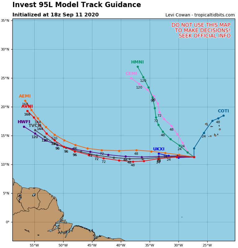
Majority of the 12Z EPS are clustered around the Operational run - EAST/North and probably out to sea round 55W/60W
2 likes

Re: ATL: INVEST 95L - Models
should I be nervous about this one?
0 likes
Too many hurricanes to remember
Re: ATL: INVEST 95L - Models
chris_fit wrote:Majority of the 12Z EPS are clustered around the Operational run - EAST/North and probably out to sea round 55W/60W
Yeah, whereas the 0Z EPS had ~1/4 of its members threatening the Caribbean and/or Bahamas/US, the 12Z has about half that doing the same or ~1/8 threatening those areas. So, now I can say that the entire 12Z suite of models is implying less of a threat to the Caribbean, CONUS, and Bahamas than before. But those areas are still far from getting the all clear at this very early stage, especially considering the other tropical features that increase unpredictability, the wild model swings that have occurred, it being La Niña, and with no LLC yet identified.
0 likes
Personal Forecast Disclaimer:
The posts in this forum are NOT official forecasts and should not be used as such. They are just the opinion of the poster and may or may not be backed by sound meteorological data. They are NOT endorsed by any professional institution or storm2k.org. For official information, please refer to the NHC and NWS products.
The posts in this forum are NOT official forecasts and should not be used as such. They are just the opinion of the poster and may or may not be backed by sound meteorological data. They are NOT endorsed by any professional institution or storm2k.org. For official information, please refer to the NHC and NWS products.
-
Hurricane Mike
- Category 2

- Posts: 562
- Joined: Tue Apr 10, 2018 7:44 am
Re: ATL: INVEST 95L - Models
LarryWx wrote:TheStormExpert wrote:There’s just not enough ridging this year for any Cape Verde long-tracking storms to hit the U.S. A contrast from the past five years.
I consider Laura a CV/longtracking storm with it becoming a TD before 50W 4 days after coming off Africa. By that measure, many seasons have none (TD east of 50W) hit the CONUS.
It depends on one’s definition, of course:
https://en.m.wikipedia.org/wiki/Meteoro ... _track.png
I for one hate when people do that. When I was a kid and teen, tracking hurricanes in the 1990s and 2000s, the tracks showed from Tropical Depression to dissipation. Now these maps show dots for when the system was an invest. I can't stand it. Erks me.
Last edited by Hurricane Mike on Fri Sep 11, 2020 2:58 pm, edited 1 time in total.
0 likes
-
otowntiger
- Category 5
- Posts: 1787
- Joined: Tue Aug 31, 2004 7:06 pm
- Location: Orlando
Re: ATL: INVEST 95L - Models
. Agreed. Trends are certainly good today, but it is still way too early to rule anything in or out given the usual uncertainties for this range but even more so given the wild day to day swings we’ve witnessed in the models this year. Wild swings and inconsistency have been more prevalent than years past.LarryWx wrote:chris_fit wrote:Majority of the 12Z EPS are clustered around the Operational run - EAST/North and probably out to sea round 55W/60W
Yeah, whereas the 0Z EPS had ~1/4 of its members threatening the Caribbean and/or Bahamas/US, the 12Z has about half that doing the same or ~1/8 threatening those areas. So, now I can say that the entire 12Z suite of models is implying less of a threat to the Caribbean, CONUS, and Bahamas than before. But those areas are still far from getting the all clear at this very early stage, especially considering the other tropical features that increase unpredictability, the wild model swings that have occurred, it being La Niña, and with no LLC yet identified.
1 likes
-
gatorcane

- S2K Supporter
- Posts: 23499
- Age: 46
- Joined: Sun Mar 13, 2005 3:54 pm
- Location: Boca Raton, FL
Re: ATL: INVEST 95L - Models
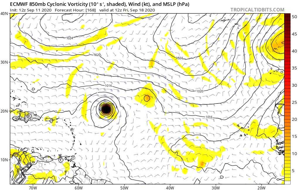
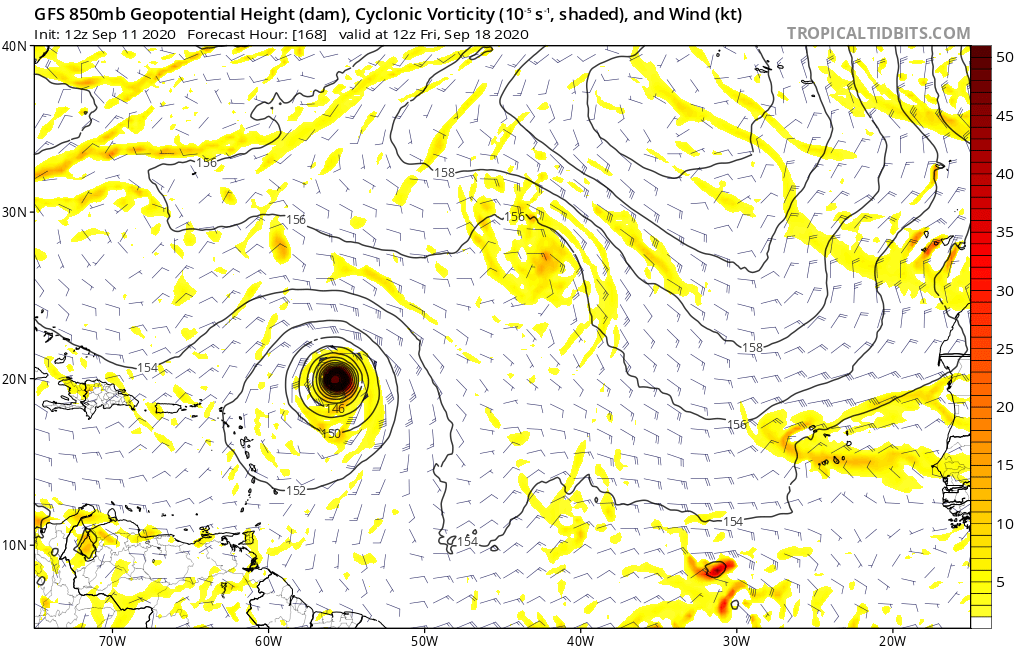
The GFS and ECMWF are in excellent agreement on where this storm is at one week out. Looks to be recurving well NE of the islands,
1 likes
Who is online
Users browsing this forum: No registered users and 24 guests