Florida Weather
Moderator: S2k Moderators
Forum rules

The posts in this forum are NOT official forecast and should not be used as such. They are just the opinion of the poster and may or may not be backed by sound meteorological data. They are NOT endorsed by any professional institution or STORM2K.
-
gatorcane

- S2K Supporter

- Posts: 23499
- Age: 46
- Joined: Sun Mar 13, 2005 3:54 pm
- Location: Boca Raton, FL
Re: Florida Weather
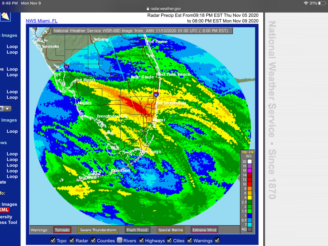
The never-ending rainy season just may be finally ending, check out the bold from our friends at NWS Miami:
https://forecast.weather.gov/product.ph ... glossary=0
Long Term (Saturday Through Wednesday)
Rain chances remain in the forecast for the very start of the
extended period as aforementioned trough associated with Eta lingers
across the Atlantic and begins to lift back north across the area as
large scale high pressure ridge build from the SW Atlantic across
the SE. But those rain chances top around 30% with no major concerns
associated with them anymore. Main reason being a strong mid level
ridge builds at the same time early this weekend across central
Florida which will suppress development overall. In fact, by late in
the weekend, area should be mainly dry for the first time in quite a
while outside some spotty showers at best.
Early next week, ridging aloft becomes shunted eastward as a robust
upper-level trough sweeps across the northern CONUS, inciting
cyclogenesis over the Upper Midwest. Consensus of model solutions
depict a cold front dropping southward across South Florida early
next week as the surface low progresses. Rain chances look to
increase ahead and along the boundary, albeit, the finer details are
subject to change as there is familiar variability between the
timing, location, strength, and position of the surface low and
attendant cold front. This will certainly be monitored with each
forecast cycle. That said, it looks like we could finally see a
reprieve from our extended Summer as a shot of drier/cooler air
pushes south behind the front by the middle of the week with
slightly below average temperatures and tolerable humidity values.
In short, it is looking like the dry season is getting the memo a
month late.
https://forecast.weather.gov/product.ph ... glossary=0
0 likes

Re: Florida Weather
Have not seen NorthJaxPro since the beginning of November. Hope all is well with him. With ETA affecting Florida this week sure missed his thoughts on this storm.
0 likes
The posts in this forum are NOT official forecasts and should not be used as such. They are just the opinion of the poster and may or may not be backed by sound meteorological data. They are NOT endorsed by any professional institution or STORM2K. For official information, please refer to products from the NHC and NWS.
-
gatorcane
- S2K Supporter
- Posts: 23499
- Age: 46
- Joined: Sun Mar 13, 2005 3:54 pm
- Location: Boca Raton, FL
Re: Florida Weather
From NWS Miami: 
The rain has been incredible this rainy season particularly the last 6 weeks or so. We have turned into a rain forest climate.
The rain has been incredible this rainy season particularly the last 6 weeks or so. We have turned into a rain forest climate.
Realizing that by stating this I might jinx it, but it appears
that the South Florida dry season should finally start with the passage of next week`s front. At least we can hope so.
https://forecast.weather.gov/product.ph ... glossary=0that the South Florida dry season should finally start with the passage of next week`s front. At least we can hope so.
1 likes
-
FlaWeatherDude

- Tropical Storm

- Posts: 110
- Age: 39
- Joined: Wed Oct 10, 2018 2:57 pm
- Location: Orlando, FL.
Re: Florida Weather
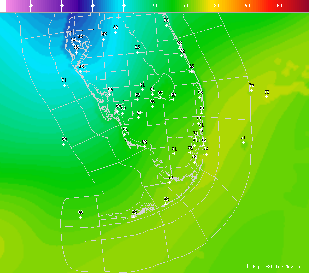
Looks like by Tuesday it should feel more like November and not September across Central Florida with highs down into the 70's and lows down into the 50's with much lower dewpoints!

0 likes
"Windy has wings to fly above the clouds".

Re: Florida Weather
While the NAO & AO remain positive and the PNA remains neutral to negative cooler temps will not be able to penetrate down the peninsula that much or will not last that much as the winds will be turning back onshore relatively quickly.
0 likes
-
toad strangler

- S2K Supporter
- Posts: 4162
- Joined: Sun Jul 28, 2013 3:09 pm
- Location: Earth
- Contact:
Re: Florida Weather
Dumped half of my treated hurricane gas into the vehicles today. Rest next weekend.
0 likes
-
FlaWeatherDude
- Tropical Storm
- Posts: 110
- Age: 39
- Joined: Wed Oct 10, 2018 2:57 pm
- Location: Orlando, FL.
Re: Florida Weather
So far it looks like Thanksgiving will be cool and pleasant! A tropical system(Kappa/Lambda?) could very well get pulled up to the Bahama's ahead of the trough early next week!
0 likes
"Windy has wings to fly above the clouds".
-
gatorcane
- S2K Supporter
- Posts: 23499
- Age: 46
- Joined: Sun Mar 13, 2005 3:54 pm
- Location: Boca Raton, FL
Re: Florida Weather
And finally the never-ending rainy season has come to an end here in South Florida (for real this time  ), nearly 1 month late. Enjoying the lowering humidity and dew points pushing into the region this afternoon.
Also quite a dew point gradient with 40s in the Tampa area up to the low 70s across South Florida.
Also quite a dew point gradient with 40s in the Tampa area up to the low 70s across South Florida.
1 likes


Re: Florida Weather
Once the rainy season ends which is now. I don’t expect much rain until May when rainy season starts up again. The cold fronts will be skeletons because of La Niña and the winds will be NE after each passage.
0 likes
-
gatorcane
- S2K Supporter
- Posts: 23499
- Age: 46
- Joined: Sun Mar 13, 2005 3:54 pm
- Location: Boca Raton, FL
Re: Florida Weather
0 likes


Re: Florida Weather
FlaWeatherDude wrote:So far it looks like Thanksgiving will be cool and pleasant! A tropical system(Kappa/Lambda?) could very well get pulled up to the Bahama's ahead of the trough early next week!
The CPC outlook which goes thru Black Friday shows much above temps likely for the whole SE in the 6-10 day outlook
0 likes
Re: Florida Weather
Magnificent November weather has finally arrived. above normal temps will return but at least we have reached the time of the year where we can tilt on the warm side of normal and still be nice. Hopefully we don't torch but the outlooks over the next month are all on the warm side of normal...not exactly a surprise with a nina in place and a base state of perpetual warmth. It's time for us to get some payback after a bruiser of a summer. As for Thanksgiving being cool...yeah I don't think so..
0 likes
-
gatorcane
- S2K Supporter
- Posts: 23499
- Age: 46
- Joined: Sun Mar 13, 2005 3:54 pm
- Location: Boca Raton, FL
Re: Florida Weather
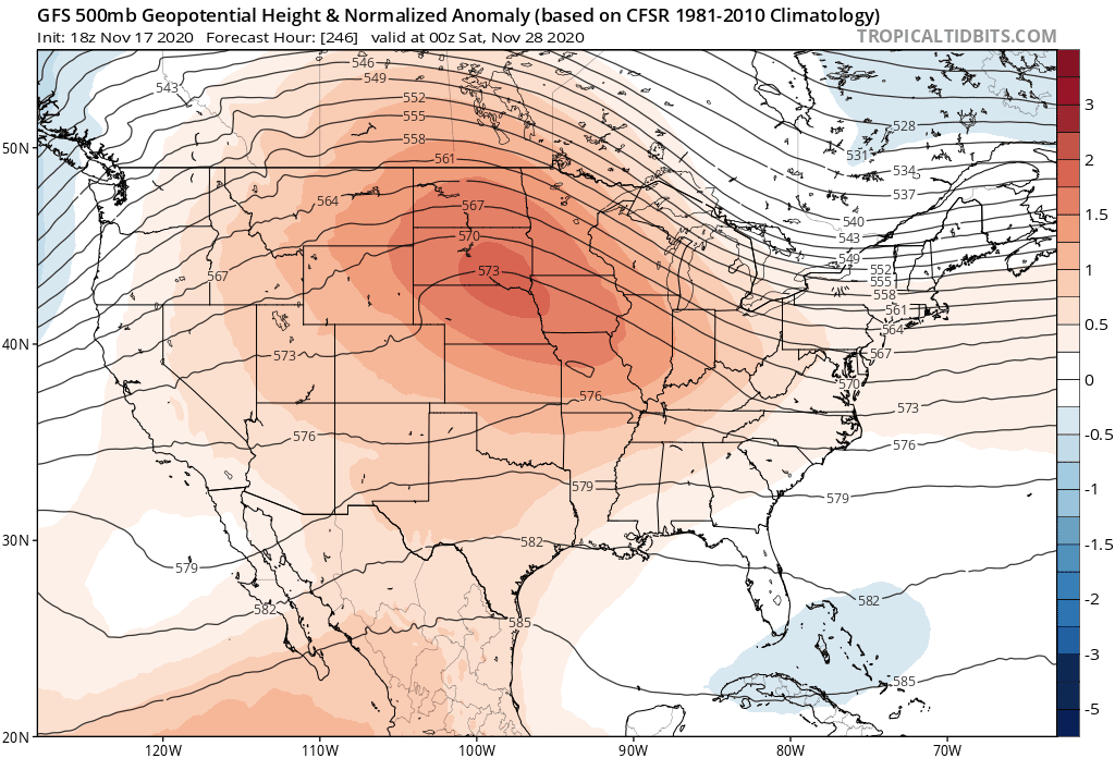
Interesting how the GFS the last 4 runs is trending towards a more amplified eastern CONUS trough which could bring some cooler temps for the Thanksgiving weekend
0 likes
Re: Florida Weather
0 likes

Re: Florida Weather
The gusts last night seemed stronger than anything Eta threw at us.
0 likes
Andrew (1992), Irene (1999), Frances (2004), Katrina (2005), Wilma (2005), Fay (2008), Irma (2017), Eta (2020), Ian (2022)
Re: Florida Weather
psyclone wrote::uarrow: I hope it's correct but even if it's not a near normal Thanksgiving counts as a win. The current weather is just divine...55 this morning in Tampa. wonderful!
Break out the parkas(I actually had to lookup the name for winter jackets, came up with parkas...to me, get below 60 and it's frostbite for me...I was born in Galveston Texas after all, ain't no parkas round here...or Tampa)....enjoy!
0 likes
-
gatorcane
- S2K Supporter
- Posts: 23499
- Age: 46
- Joined: Sun Mar 13, 2005 3:54 pm
- Location: Boca Raton, FL
Re: Florida Weather
Euro long-range with quite a mid-level low that looks to phase with a shortwave and the GFS seems be be trending toward it, if it happens, would bring quite chilly temps to Florida:
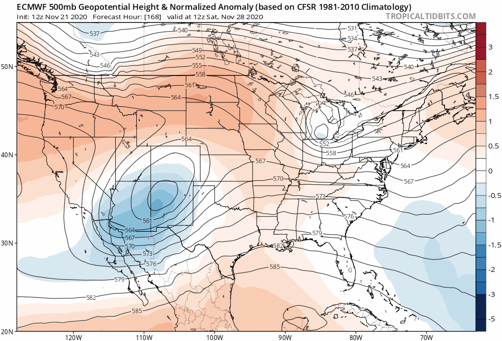
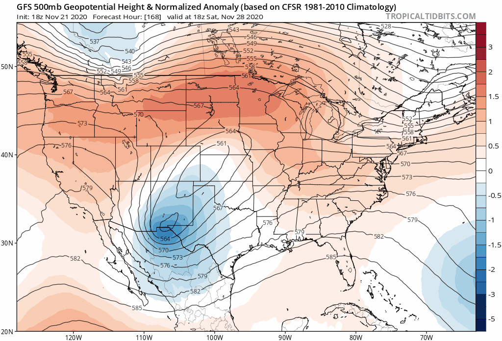
The NAO looks to be going toward negative so this may actually happen:
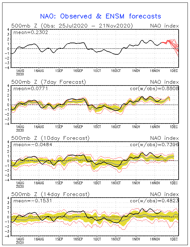
The NAO looks to be going toward negative so this may actually happen:
1 likes

Re: Florida Weather
True enough, it should be a nice cool down. Keep in mind that this is less "polar" in origin and primarily a strong cut off maritime low sweeping across from the Pacific. Regardless, while less then frigid it'll be a very nice change for a good few days. Bring it on (and let NO part of it be Greek LOL).
0 likes
Personal Forecast Disclaimer:
The posts in this forum are NOT official forecast and should not be used as such. They are just the opinion of the poster and may or may not be backed by sound meteorological data. They are NOT endorsed by any professional institution or storm2k.org. For official information, please refer to the NHC and NWS products.
The posts in this forum are NOT official forecast and should not be used as such. They are just the opinion of the poster and may or may not be backed by sound meteorological data. They are NOT endorsed by any professional institution or storm2k.org. For official information, please refer to the NHC and NWS products.
-
gatorcane
- S2K Supporter
- Posts: 23499
- Age: 46
- Joined: Sun Mar 13, 2005 3:54 pm
- Location: Boca Raton, FL
Re: Florida Weather
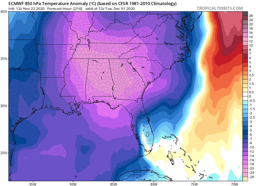
Looks like the airmass is more potent than just a Pacific airmass. Today’s 12Z Euro for night of Dec 1st has low is the mid 30s into Central Florida while the GFS is around 60F (but the night before has upper 40s to around 50F). The normally cold-biases CMC had mid 20s. 
1 likes
Return to “USA & Caribbean Weather”
Who is online
Users browsing this forum: Captmorg70, Edwards Limestone, Google [Bot], South Texas Storms and 104 guests