Texas Winter 2020-2021

Winter Weather Discussion

Moderator: S2k Moderators

Forum rules

The posts in this forum are NOT official forecast and should not be used as such. They are just the opinion of the poster and may or may not be backed by sound meteorological data. They are NOT endorsed by any professional institution or STORM2K.

Help Support Storm2K
Message
Author
User avatar
Iceresistance
Category 5
Category 5
Posts: 8908
Age: 20
Joined: Sat Oct 10, 2020 9:45 am
Location: Tecumseh, OK/Norman, OK

Re: Texas Winter 2020-2021

#2141 Postby Iceresistance » Thu Jan 14, 2021 9:31 am

Wind Advisory west of I-35 in Texas, also west of I-35E in the Dallas metroplex. (Along & west of US-69 in Oklahoma)

The Wind Advisory is for winds 20-30 mph, gusts up to 55 mph in Panhandles of Texas & Oklahoma, 40-50 mph elsewhere in the Advisory in Texas & Oklahoma today.

Tomorrow's wind is expected to be higher, 40-50 mph gusts is going to be common down to I-30, up to 60 mph gusts in the NE Texas panhandle, NW Oklahoma (Including the eastern side of the Panhandle) & SW Kansas.

Image

NWS-Norman
Image

NWS-Dallas
Image
Last edited by Iceresistance on Thu Jan 14, 2021 11:22 am, edited 1 time in total.
1 likes   
Bill 2015 & Beta 2020

Winter 2020-2021 :cold:

All observations are in Tecumseh, OK unless otherwise noted.

Winter posts are focused mainly for Oklahoma & Texas.

Take any of my forecasts with a grain of salt, refer to the NWS, SPC, and NHC for official information

Never say Never with weather! Because ANYTHING is possible!

User avatar
bubba hotep
S2K Supporter
S2K Supporter
Posts: 5452
Joined: Wed Dec 28, 2016 1:00 am
Location: Collin County Texas

Re: Texas Winter 2020-2021

#2142 Postby bubba hotep » Thu Jan 14, 2021 10:52 am

Looks like another nice rain event setting up for portions of Texas but not much support for snow or below normal temps. Ensembles are building some cold air in our typical source region but they also show above normal heights from Northern Mexico into Texas. This setup keeps the cold up north or bleeding off into the East.
3 likes   
Winter time post are almost exclusively focused on the DFW area.

User avatar
Quixotic
Category 2
Category 2
Posts: 572
Joined: Tue Feb 14, 2017 12:27 am
Location: Frisco

Re: Texas Winter 2020-2021

#2143 Postby Quixotic » Thu Jan 14, 2021 11:31 am

I beg to differ on Arctic intrusions. Our snowiest years had little in the way of arctic air. It was mostly home grown. The weather we had last week - cloudy, damp and chilly with a north wind - prior to the snowstorm south of here was reminiscent of 09 - 10. Years where we get blasted with bitter cold usually means freezing rain or sleet due to the shallow cold, or suppression altogether. We have cashed in when blocking keeps the high in place and it slowly moderates (and these storms are great with the powder and high ratios) but they are few and far between.
That said, I’m all for cold. For us it is the limited commodity. Get it here and even the most subtle SWs can give us measurable snow.
5 likes   

User avatar
bubba hotep
S2K Supporter
S2K Supporter
Posts: 5452
Joined: Wed Dec 28, 2016 1:00 am
Location: Collin County Texas

Re: Texas Winter 2020-2021

#2144 Postby bubba hotep » Thu Jan 14, 2021 11:49 am

Quixotic wrote:I beg to differ on Arctic intrusions. Our snowiest years had little in the way of arctic air. It was mostly home grown. The weather we had last week - cloudy, damp and chilly with a north wind - prior to the snowstorm south of here was reminiscent of 09 - 10. Years where we get blasted with bitter cold usually means freezing rain or sleet due to the shallow cold, or suppression altogether. We have cashed in when blocking keeps the high in place and it slowly moderates (and these storms are great with the powder and high ratios) but they are few and far between.
That said, I’m all for cold. For us it is the limited commodity. Get it here and even the most subtle SWs can give us measurable snow.


Yea, I'm not a fan of big cold because it usually comes in the form of positive tilted long waves with no chance of a storm coming out of the SW because everything gets sheared out.
7 likes   
Winter time post are almost exclusively focused on the DFW area.

User avatar
TheProfessor
Professional-Met
Professional-Met
Posts: 3505
Age: 27
Joined: Tue Dec 03, 2013 10:56 am
Location: Wichita, Kansas

Re: Texas Winter 2020-2021

#2145 Postby TheProfessor » Thu Jan 14, 2021 12:13 pm

The main benefit to real deep cold is staying power when it comes to winter weather, which is rare in Texas. If you can get a hit on the leaning edge of the cold (Sleet is more likely, but you can still get a transition to snow depending on the 500 setup) then you can keep that snow/sleet on the ground for more than 1 to 2 days. The unfortunate thing for Texas is that clipper systems are exceptionally rare this far west (They can wind up pretty far south further east though). They make the cold winters interesting and was one of the reasons why I loved northwest flow in Ohio.
3 likes   
An alumnus of The Ohio State University.

Your local National Weather Service office is your best source for weather information.

User avatar
Haris
Category 5
Category 5
Posts: 1808
Joined: Mon Nov 27, 2017 8:19 pm
Location: ( Bee Cave) West Austin, Texas

Re: Texas Winter 2020-2021

#2146 Postby Haris » Thu Jan 14, 2021 12:27 pm

Starting air temp in Austin during our Dec 2017 snowfall was 41F and wad 36F this past week. Best snows down here funny enough happen when it is only marginally cold. More moisture can linger then... Whenever we get those huge arctic air masses, it dries out all the precipiation and we are left with freezing drizzle :spam:
4 likes   
Weather geek and a storm spotter in West Austin. Not a degreed meteorologist. Big snow fan. Love rain and cold! Despise heat!

User avatar
Iceresistance
Category 5
Category 5
Posts: 8908
Age: 20
Joined: Sat Oct 10, 2020 9:45 am
Location: Tecumseh, OK/Norman, OK

Re: Texas Winter 2020-2021

#2147 Postby Iceresistance » Thu Jan 14, 2021 12:44 pm

12z GFS wants Double Trouble Snowstorms, even though it's 2 weeks away
(Model run ends in the middle of Storm #2)

Image

Total Snowfall (10:1) (Using 24-hour to better show the 2 storms)

Image

500mb Geopotental Height (Long-lasting Block over Greenland & another one develops over the NW US when the snowstorms start)

Image
1 likes   
Bill 2015 & Beta 2020

Winter 2020-2021 :cold:

All observations are in Tecumseh, OK unless otherwise noted.

Winter posts are focused mainly for Oklahoma & Texas.

Take any of my forecasts with a grain of salt, refer to the NWS, SPC, and NHC for official information

Never say Never with weather! Because ANYTHING is possible!

orangeblood
S2K Supporter
S2K Supporter
Posts: 3334
Joined: Tue Dec 15, 2009 6:14 pm
Location: Fort Worth, TX

Re: Texas Winter 2020-2021

#2148 Postby orangeblood » Thu Jan 14, 2021 1:12 pm

GEFS looks great at the surface just beyond 10 day time frame...High Pressure lined up from Siberia down to Central North America. Would force winter storm track much further south. Nice trend showing up for late January!!

Image
5 likes   

User avatar
Iceresistance
Category 5
Category 5
Posts: 8908
Age: 20
Joined: Sat Oct 10, 2020 9:45 am
Location: Tecumseh, OK/Norman, OK

Re: Texas Winter 2020-2021

#2149 Postby Iceresistance » Thu Jan 14, 2021 1:22 pm

orangeblood wrote:GEFS looks great at the surface just beyond 10 day time frame...High Pressure lined up from Siberia down to Central North America. Would force winter storm track much further south. Nice trend showing up for late January!!

https://www.tropicaltidbits.com/analysis/models/gfs-ens/2021011412/gfs-ens_mslpaNorm_nhem_47.png

Also note one over the Northern US, that might force one over Texas & Oklahoma
2 likes   
Bill 2015 & Beta 2020

Winter 2020-2021 :cold:

All observations are in Tecumseh, OK unless otherwise noted.

Winter posts are focused mainly for Oklahoma & Texas.

Take any of my forecasts with a grain of salt, refer to the NWS, SPC, and NHC for official information

Never say Never with weather! Because ANYTHING is possible!

User avatar
Quixotic
Category 2
Category 2
Posts: 572
Joined: Tue Feb 14, 2017 12:27 am
Location: Frisco

Re: Texas Winter 2020-2021

#2150 Postby Quixotic » Thu Jan 14, 2021 4:43 pm

Keeps trying to show cross polar flow.
2 likes   

User avatar
bubba hotep
S2K Supporter
S2K Supporter
Posts: 5452
Joined: Wed Dec 28, 2016 1:00 am
Location: Collin County Texas

Re: Texas Winter 2020-2021

#2151 Postby bubba hotep » Thu Jan 14, 2021 5:33 pm

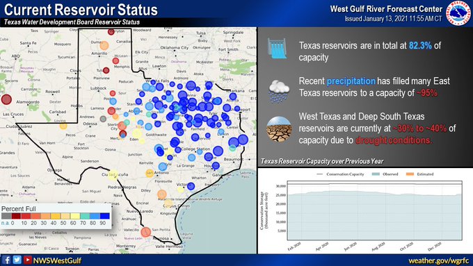
Looks like another round of widespread rain for Texas! And this is with lakes already looking pretty good.

Image

Image
4 likes   
Winter time post are almost exclusively focused on the DFW area.

Brent
S2K Supporter
S2K Supporter
Posts: 37086
Age: 35
Joined: Sun May 16, 2004 10:30 pm
Location: Tulsa Oklahoma
Contact:

Re: Texas Winter 2020-2021

#2152 Postby Brent » Thu Jan 14, 2021 6:25 pm

bubba hotep wrote:
Quixotic wrote:I beg to differ on Arctic intrusions. Our snowiest years had little in the way of arctic air. It was mostly home grown. The weather we had last week - cloudy, damp and chilly with a north wind - prior to the snowstorm south of here was reminiscent of 09 - 10. Years where we get blasted with bitter cold usually means freezing rain or sleet due to the shallow cold, or suppression altogether. We have cashed in when blocking keeps the high in place and it slowly moderates (and these storms are great with the powder and high ratios) but they are few and far between.
That said, I’m all for cold. For us it is the limited commodity. Get it here and even the most subtle SWs can give us measurable snow.


Yea, I'm not a fan of big cold because it usually comes in the form of positive tilted long waves with no chance of a storm coming out of the SW because everything gets sheared out.


yeah I have to agree... even living back east I literally only remember probably one real setup that had arctic air(January 2014), everything else was much like what has happened in Texas the last couple storms, very borderline temps

all too often when it's really cold its sunny and dry I've noticed
1 likes   
#neversummer

Cpv17
Category 5
Category 5
Posts: 4311
Joined: Wed Dec 07, 2016 2:24 pm
Location: Wharton/El Campo, TX

Re: Texas Winter 2020-2021

#2153 Postby Cpv17 » Thu Jan 14, 2021 6:38 pm

Quixotic wrote:Keeps trying to show cross polar flow.


It’s going to have a difficult time pushing south. We actually could be dealing with above normal temps the second half of January after this cold blast this weekend with what the models are showing. EPO isn’t cooperating I guess. The cold looks to be staying up north.
0 likes   

User avatar
cheezyWXguy
Category 5
Category 5
Posts: 5528
Joined: Mon Feb 13, 2006 12:29 am
Location: Dallas, TX

Re: Texas Winter 2020-2021

#2154 Postby cheezyWXguy » Thu Jan 14, 2021 7:13 pm

Cpv17 wrote:
Quixotic wrote:Keeps trying to show cross polar flow.


It’s going to have a difficult time pushing south. We actually could be dealing with above normal temps the second half of January after this cold blast this weekend with what the models are showing. EPO isn’t cooperating I guess. The cold looks to be staying up north.

It’s possible, but the long range has been wildly inconsistent run to run. Last week it looked like there would be multiple chances a winter precip next week, there’s no reason why these long range forecasts are any more accurate than they were last week.
1 likes   

Cpv17
Category 5
Category 5
Posts: 4311
Joined: Wed Dec 07, 2016 2:24 pm
Location: Wharton/El Campo, TX

Re: Texas Winter 2020-2021

#2155 Postby Cpv17 » Thu Jan 14, 2021 8:20 pm

cheezyWXguy wrote:
Cpv17 wrote:
Quixotic wrote:Keeps trying to show cross polar flow.


It’s going to have a difficult time pushing south. We actually could be dealing with above normal temps the second half of January after this cold blast this weekend with what the models are showing. EPO isn’t cooperating I guess. The cold looks to be staying up north.

It’s possible, but the long range has been wildly inconsistent run to run. Last week it looked like there would be multiple chances a winter precip next week, there’s no reason why these long range forecasts are any more accurate than they were last week.


Yeah, true. Like Orangeblood said, it’ll mainly depend on the EPO. If anyone has a forecast graphic of that, that would be great!
0 likes   

User avatar
bubba hotep
S2K Supporter
S2K Supporter
Posts: 5452
Joined: Wed Dec 28, 2016 1:00 am
Location: Collin County Texas

Re: Texas Winter 2020-2021

#2156 Postby bubba hotep » Thu Jan 14, 2021 8:41 pm

Cpv17 wrote:
cheezyWXguy wrote:
Cpv17 wrote:
It’s going to have a difficult time pushing south. We actually could be dealing with above normal temps the second half of January after this cold blast this weekend with what the models are showing. EPO isn’t cooperating I guess. The cold looks to be staying up north.

It’s possible, but the long range has been wildly inconsistent run to run. Last week it looked like there would be multiple chances a winter precip next week, there’s no reason why these long range forecasts are any more accurate than they were last week.


Yeah, true. Like Orangeblood said, it’ll mainly depend on the EPO. If anyone has a forecast graphic of that, that would be great!


When the AO is negative the WPO plays a bigger role than normal in getting cold down into the US. The WPO has been stubbornly positive throughout this latest -AO. I'm not too concerned with cold as the SSW lag composites that best analog to our current setup show cold more so in the 30 - 45+ range than in the near term. That has me thinking more mid-February into March, also, wave lengths start to transition to Spring during that period and we might be able to avoid suppression via positive tilted long wave troughs. I wouldn't be surprised to see a big late winter storm for N. Texas in that timeframe.
1 likes   
Winter time post are almost exclusively focused on the DFW area.

User avatar
bubba hotep
S2K Supporter
S2K Supporter
Posts: 5452
Joined: Wed Dec 28, 2016 1:00 am
Location: Collin County Texas

Re: Texas Winter 2020-2021

#2157 Postby bubba hotep » Thu Jan 14, 2021 8:48 pm

I think the GFS-P is good to go. It is showing another winter wx event south of DFW in the long range lol

Image
5 likes   
Winter time post are almost exclusively focused on the DFW area.

User avatar
txtwister78
Category 5
Category 5
Posts: 1005
Joined: Wed Jan 30, 2019 12:56 pm
Location: San Antonio

Re: Texas Winter 2020-2021

#2158 Postby txtwister78 » Thu Jan 14, 2021 9:50 pm

Image

Image

I think the -PNA will be the limiting factor for true cold air. As others have mentioned, you don't need a -EPO to get snow in TX. We just witnessed that twice and in both cases the EPO was slightly +. More importantly the PNA was also +.

This is a classic -PNA look on the Euro blunting the cold air from the NW and pushing it east. This will create a battle zone up north (Midwest). I think if we can get the PNA back to a more neutral or positive look we should see more cold further south (enough to create winter precip situations) instead of rain (which we need) that should arrive next week.
3 likes   

orangeblood
S2K Supporter
S2K Supporter
Posts: 3334
Joined: Tue Dec 15, 2009 6:14 pm
Location: Fort Worth, TX

Re: Texas Winter 2020-2021

#2159 Postby orangeblood » Fri Jan 15, 2021 8:51 am

Cpv17 wrote:
cheezyWXguy wrote:
Cpv17 wrote:
It’s going to have a difficult time pushing south. We actually could be dealing with above normal temps the second half of January after this cold blast this weekend with what the models are showing. EPO isn’t cooperating I guess. The cold looks to be staying up north.

It’s possible, but the long range has been wildly inconsistent run to run. Last week it looked like there would be multiple chances a winter precip next week, there’s no reason why these long range forecasts are any more accurate than they were last week.


Yeah, true. Like Orangeblood said, it’ll mainly depend on the EPO. If anyone has a forecast graphic of that, that would be great!


They are rare but IMO, the most memorable winter weather events are the ones that stick around for a few days and almost always need a Negative EPO to pull it off...over the past decade, Early December 2013 was the one that stands out the most to me. Temps crashing into the upper 20's followed by over 1" QPF and temps remaining below freezing for 4 days following. That was a classic overrunning event with a Negative PNA/EPO combo. So I'll take my chances with a negative PNA, gives you a much greater chance of precip. Cross your fingers the EPO begins to cooperate!!!

Latest Euro ENS EPO forecast, its all over the place but trending negative
Image
2 likes   

User avatar
Iceresistance
Category 5
Category 5
Posts: 8908
Age: 20
Joined: Sat Oct 10, 2020 9:45 am
Location: Tecumseh, OK/Norman, OK

Re: Texas Winter 2020-2021

#2160 Postby Iceresistance » Fri Jan 15, 2021 8:52 am

This feature was not there in the last several GFS runs . . . Even though it's in Oklahoma

Image

24-hour 10:1 snowfall :eek:

Image

Blocking over Alaska & Greenland is the reason why I might have some snow :cold:

Image
0 likes   
Bill 2015 & Beta 2020

Winter 2020-2021 :cold:

All observations are in Tecumseh, OK unless otherwise noted.

Winter posts are focused mainly for Oklahoma & Texas.

Take any of my forecasts with a grain of salt, refer to the NWS, SPC, and NHC for official information

Never say Never with weather! Because ANYTHING is possible!


Return to “Winter Weather”

Who is online

Users browsing this forum: No registered users and 28 guests