https://twitter.com/CC_StormWatch/status/1441263407810838539
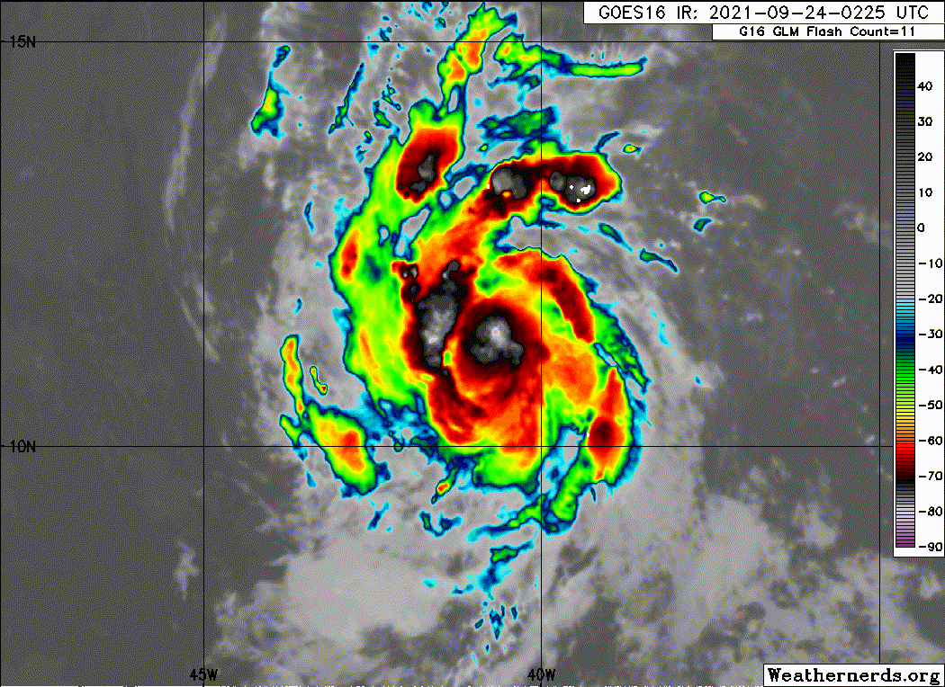
Seems over the last hour or 2 Sam has a pulse down for sure, but based on this the eyewall may be complete and its starting to gain more latitude imo
ATL: SAM - Remnants - Discussion
Moderator: S2k Moderators
-
Stormybajan

- Category 1

- Posts: 428
- Joined: Thu May 20, 2021 3:21 pm
- Location: Windward Islands
-
grapealcoholic
- Category 2

- Posts: 634
- Joined: Tue Aug 10, 2021 3:26 pm

-
Sciencerocks
- Category 5

- Posts: 7287
- Age: 38
- Joined: Thu Jul 06, 2017 1:51 am
Re: ATL: SAM - Hurricane - Discussion
AL, 18, 2021092406, , BEST, 0, 114N, 416W, 65, 993, HU, 34, NEQ, 50, 40, 30, 40, 1011, 120, 15, 0, 0, L, 0, , 0, 0, SAM, D, 0, , 0, 0, 0, 0, genesis-num, 038,
AL, 18, 2021092406, , BEST, 0, 114N, 416W, 65, 993, HU, 50, NEQ, 30, 20, 15, 20, 1011, 120, 15, 0, 0, L, 0, , 0, 0, SAM, D, 0, , 0, 0, 0, 0, genesis-num, 038,
AL, 18, 2021092406, , BEST, 0, 114N, 416W, 65, 993, HU, 64, NEQ, 15, 0, 0, 0, 1011, 120, 15, 0, 0, L, 0, , 0, 0, SAM, D, 0, , 0, 0, 0, 0, genesis-num, 038,
3 likes
-
galaxy401

- Category 5
- Posts: 2299
- Age: 28
- Joined: Sat Aug 25, 2012 9:04 pm
- Location: Casa Grande, Arizona
Re: ATL: SAM - Tropical Storm - Discussion
Went from a TD to a hurricane in just 24 hours. Since Sam is moving relatively slowly, we got a lot of time to watch its movements. It still won't reach 60W by Tuesday. Really curious on how strong he will be.
3 likes
Got my eyes on moving right into Hurricane Alley: Florida.

Re: ATL: SAM - Hurricane - Discussion
Subtrop wrote:AL, 18, 2021092406, , BEST, 0, 114N, 416W, 65, 993, HU, 34, NEQ, 50, 40, 30, 40, 1011, 120, 15, 0, 0, L, 0, , 0, 0, SAM, D, 0, , 0, 0, 0, 0, genesis-num, 038,
AL, 18, 2021092406, , BEST, 0, 114N, 416W, 65, 993, HU, 50, NEQ, 30, 20, 15, 20, 1011, 120, 15, 0, 0, L, 0, , 0, 0, SAM, D, 0, , 0, 0, 0, 0, genesis-num, 038,
AL, 18, 2021092406, , BEST, 0, 114N, 416W, 65, 993, HU, 64, NEQ, 15, 0, 0, 0, 1011, 120, 15, 0, 0, L, 0, , 0, 0, SAM, D, 0, , 0, 0, 0, 0, genesis-num, 038,
Looks like we have hurricane Sam. If the NHC follows this data then the first hurricane advisory will be only 18 hours after Sam became a tropical storm.
1 likes
-
Sciencerocks
- Category 5
- Posts: 7287
- Age: 38
- Joined: Thu Jul 06, 2017 1:51 am
-
Extratropical94

- Professional-Met

- Posts: 3535
- Age: 29
- Joined: Wed Oct 20, 2010 6:36 am
- Location: Hamburg, Germany
- Contact:
Re: ATL: SAM - Tropical Storm - Discussion
7th hurricane of the season, now forecast to reach cat 4
INIT 24/0900Z 11.5N 42.2W 65 KT 75 MPH
12H 24/1800Z 11.7N 44.0W 80 KT 90 MPH
24H 25/0600Z 12.1N 45.9W 95 KT 110 MPH
36H 25/1800Z 12.5N 47.4W 105 KT 120 MPH
48H 26/0600Z 12.9N 48.7W 115 KT 130 MPH
60H 26/1800Z 13.4N 50.0W 115 KT 130 MPH
72H 27/0600Z 14.1N 51.1W 110 KT 125 MPH
96H 28/0600Z 15.9N 53.8W 110 KT 125 MPH
120H 29/0600Z 17.8N 56.6W 110 KT 125 MPH
4 likes
54° 11' 59'' N, 9° 9' 20'' E
Boomer Sooner!
Go Broncos! Go Cards! Go Niners!
- Daniel
Boomer Sooner!
Go Broncos! Go Cards! Go Niners!
- Daniel
Re: ATL: SAM - Tropical Storm - Discussion
Extratropical94 wrote:7th hurricane of the season, now forecast to reach cat 4INIT 24/0900Z 11.5N 42.2W 65 KT 75 MPH
12H 24/1800Z 11.7N 44.0W 80 KT 90 MPH
24H 25/0600Z 12.1N 45.9W 95 KT 110 MPH
36H 25/1800Z 12.5N 47.4W 105 KT 120 MPH
48H 26/0600Z 12.9N 48.7W 115 KT 130 MPH
60H 26/1800Z 13.4N 50.0W 115 KT 130 MPH
72H 27/0600Z 14.1N 51.1W 110 KT 125 MPH
96H 28/0600Z 15.9N 53.8W 110 KT 125 MPH
120H 29/0600Z 17.8N 56.6W 110 KT 125 MPH
Since it's very likely that Sam will become a MH, that means we would be at 18/7/4 with October still to go.
3 likes
-
cycloneye

- Admin

- Posts: 139122
- Age: 67
- Joined: Thu Oct 10, 2002 10:54 am
- Location: San Juan, Puerto Rico
Re: ATL: SAM - Hurricane - Discussion
galaxy401 wrote:Went from a TD to a hurricane in just 24 hours. Since Sam is moving relatively slowly, we got a lot of time to watch its movements. It still won't reach 60W by Tuesday. Really curious on how strong he will be.
And recon will be flying starting on Monday morning and those missions will be very important especially the gulfstream ones.
3 likes
Visit the Caribbean-Central America Weather Thread where you can find at first post web cams,radars
and observations from Caribbean basin members Click Here
and observations from Caribbean basin members Click Here
-
Iceresistance

- Category 5
- Posts: 8915
- Age: 20
- Joined: Sat Oct 10, 2020 9:45 am
- Location: Tecumseh, OK/Norman, OK
Re: ATL: SAM - Hurricane - Discussion
That Monstrous Northern Band is limiting Sam somewhat, it's only a matter of time before this dies out & there will be virtually nothing that will stop him from RI . . .

0 likes
Bill 2015 & Beta 2020
Winter 2020-2021
All observations are in Tecumseh, OK unless otherwise noted.
Winter posts are focused mainly for Oklahoma & Texas.
Take any of my forecasts with a grain of salt, refer to the NWS, SPC, and NHC for official information
Never say Never with weather! Because ANYTHING is possible!
Winter 2020-2021
All observations are in Tecumseh, OK unless otherwise noted.
Winter posts are focused mainly for Oklahoma & Texas.
Take any of my forecasts with a grain of salt, refer to the NWS, SPC, and NHC for official information
Never say Never with weather! Because ANYTHING is possible!

Re: ATL: SAM - Hurricane - Discussion
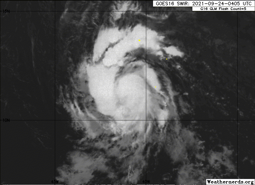
When are we thinking the eye starts clearing out? Modeling has it popping out late this morning, but we have seen systems with tight cores take a little longer than usual to do so.
0 likes
Kendall -> SLO -> PBC
Memorable Storms: Katrina (for its Florida landfall...) Wilma Matthew Irma
Memorable Storms: Katrina (for its Florida landfall...) Wilma Matthew Irma

Re: ATL: SAM - Hurricane - Discussion
Not a good structure this morning. Like Larry, Sam is dealing with a massive outer band that needs to dissipate.
0 likes
Irene '11 Sandy '12 Hermine '16 5/15/2018 Derecho Fay '20 Isaias '20 Elsa '21 Henri '21 Ida '21
I am only a meteorology enthusiast who knows a decent amount about tropical cyclones. Look to the professional mets, the NHC, or your local weather office for the best information.
I am only a meteorology enthusiast who knows a decent amount about tropical cyclones. Look to the professional mets, the NHC, or your local weather office for the best information.
Re: ATL: SAM - Hurricane - Discussion
Looks like the outer band is slowly losing strength (peaked about 2 - 3 hours ago), but it'll still take a little while before it has dissipated.
0 likes
Re: ATL: SAM - Hurricane - Discussion
Note that both HWRF and HMON also keep Sam at the same pressure/intensity for the next 8 - 10 hours or so until it manages to become more symmetrical and manages to get rid of its northern band. Only afterwards (21z/00z) they start with RI.
2 likes
-
Blown Away

- S2K Supporter

- Posts: 9863
- Joined: Wed May 26, 2004 6:17 am
Re: ATL: SAM - Hurricane - Discussion

Sam a little ragged IMO on the IR this morning, but likely healthy at the low levels.
3 likes
Hurricane Eye Experience: David 79, Irene 99, Frances 04, Jeanne 04, Wilma 05...
Hurricane Brush Experience: Andrew 92, Erin 95, Floyd 99, Matthew 16, Irma 17, Ian 22, Nicole 22…
Hurricane Brush Experience: Andrew 92, Erin 95, Floyd 99, Matthew 16, Irma 17, Ian 22, Nicole 22…
-
tolakram
- Admin
- Posts: 19165
- Age: 60
- Joined: Sun Aug 27, 2006 8:23 pm
- Location: Florence, KY (name is Mark)
Re: ATL: SAM - Hurricane - Discussion
6 likes
M a r k
- - - - -
Join us in chat: Storm2K Chatroom Invite. Android and IOS apps also available.
The posts in this forum are NOT official forecasts and should not be used as such. Posts are NOT endorsed by any professional institution or STORM2K.org. For official information and forecasts, please refer to NHC and NWS products.
-
cheezyWXguy

- Category 5
- Posts: 5536
- Joined: Mon Feb 13, 2006 12:29 am
- Location: Dallas, TX
Re: ATL: SAM - Hurricane - Discussion
Interesting structural changes going on. Although the cdo as warmed, it looks like it’s expanding a little bit. And now that the northern band is quickly weakening I don’t think it’ll be long before colder cloud tops reappear in the cdo
2 likes
-
HurricaneEnzo

- Category 2
- Posts: 723
- Joined: Wed Mar 14, 2018 12:18 pm
- Location: Newport, NC (Hurricane Alley)
Re: ATL: SAM - Tropical Storm - Discussion
kevin wrote:Extratropical94 wrote:7th hurricane of the season, now forecast to reach cat 4INIT 24/0900Z 11.5N 42.2W 65 KT 75 MPH
12H 24/1800Z 11.7N 44.0W 80 KT 90 MPH
24H 25/0600Z 12.1N 45.9W 95 KT 110 MPH
36H 25/1800Z 12.5N 47.4W 105 KT 120 MPH
48H 26/0600Z 12.9N 48.7W 115 KT 130 MPH
60H 26/1800Z 13.4N 50.0W 115 KT 130 MPH
72H 27/0600Z 14.1N 51.1W 110 KT 125 MPH
96H 28/0600Z 15.9N 53.8W 110 KT 125 MPH
120H 29/0600Z 17.8N 56.6W 110 KT 125 MPH
Since it's very likely that Sam will become a MH, that means we would be at 18/7/4 with October still to go.
Don't forget November. We had the 2 strongest storms of the year last season in November. We are not likely to repeat that but you never know.
2 likes
Bertha 96' - Fran 96' - Bonnie 98' - Dennis 99' - Floyd 99' - Isabel 03' - Alex 04' - Ophelia 05' - Irene 11' - Arthur 14' - Matthew 16' - Florence 18' - Dorian 19' - Isaias 20' (countless other tropical storms and Hurricane swipes)
I am not a Professional Met just an enthusiast. Get your weather forecasts from the Pros!
I am not a Professional Met just an enthusiast. Get your weather forecasts from the Pros!
-
cycloneye
- Admin
- Posts: 139122
- Age: 67
- Joined: Thu Oct 10, 2002 10:54 am
- Location: San Juan, Puerto Rico
Re: ATL: SAM - Hurricane - Discussion
A. 18L (SAM)
B. 24/1130Z
C. 11.4N
D. 42.9W
E. THREE/GOES-E
F. T4.5/4.5
G. IR/EIR/VIS
H. REMARKS...SYSTEM IS EMBEDDED IN MG RESULTING IN A DT OF 4.0. THE
SYSTEM HAS A DISTINCT BANDING FEATURE SEEN ON VISIBLE SATELLITE IMAGERY
THAT IS TIGHTLY WRAPPING INTO THE CORE. TOWERING THUNDERSTORMS CONTINUE
TO FORM AROUND SYSTEM LLCC ON VISIBLE SATELLITE IMAGERY INDICATING A
DEEPENING SYSTEM. THE 24 HR TREND IS DEVELOPING. MET IS 4.0 AND PT IS
4.5. FT IS BASED ON PT DUE TO THE UNCERTAINTY OF THE EXACT LLCC POSITION.
I. ADDL POSITIONS
NIL
...PATEL
0 likes
Visit the Caribbean-Central America Weather Thread where you can find at first post web cams,radars
and observations from Caribbean basin members Click Here
and observations from Caribbean basin members Click Here
Who is online
Users browsing this forum: MarioProtVI and 26 guests