2021 Global Model Runs Discussion (Out thru day 16)

This is the general tropical discussion area. Anyone can take their shot at predicting a storms path.

Moderator: S2k Moderators

Forum rules

The posts in this forum are NOT official forecasts and should not be used as such. They are just the opinion of the poster and may or may not be backed by sound meteorological data. They are NOT endorsed by any professional institution or STORM2K. For official information, please refer to products from the National Hurricane Center and National Weather Service.

Help Support Storm2K
Message
Author
User avatar
blp
Category 5
Category 5
Posts: 2805
Age: 45
Joined: Thu Sep 09, 2004 7:51 pm
Location: Miami, FL
Contact:

Re: 2021 Global Model Runs Discussion (Out thru day 16)

#1741 Postby blp » Fri Sep 24, 2021 7:24 pm

toad strangler wrote:
blp wrote:Nope, it can show it 10 runs in a row, I won't bite. Need to see another model onboard first. GFS has a long history of phantoms from the Columbian low.


Of course. Relax. There isn't another model that reaches this far out :lol: Nobody is sounding an alarm.


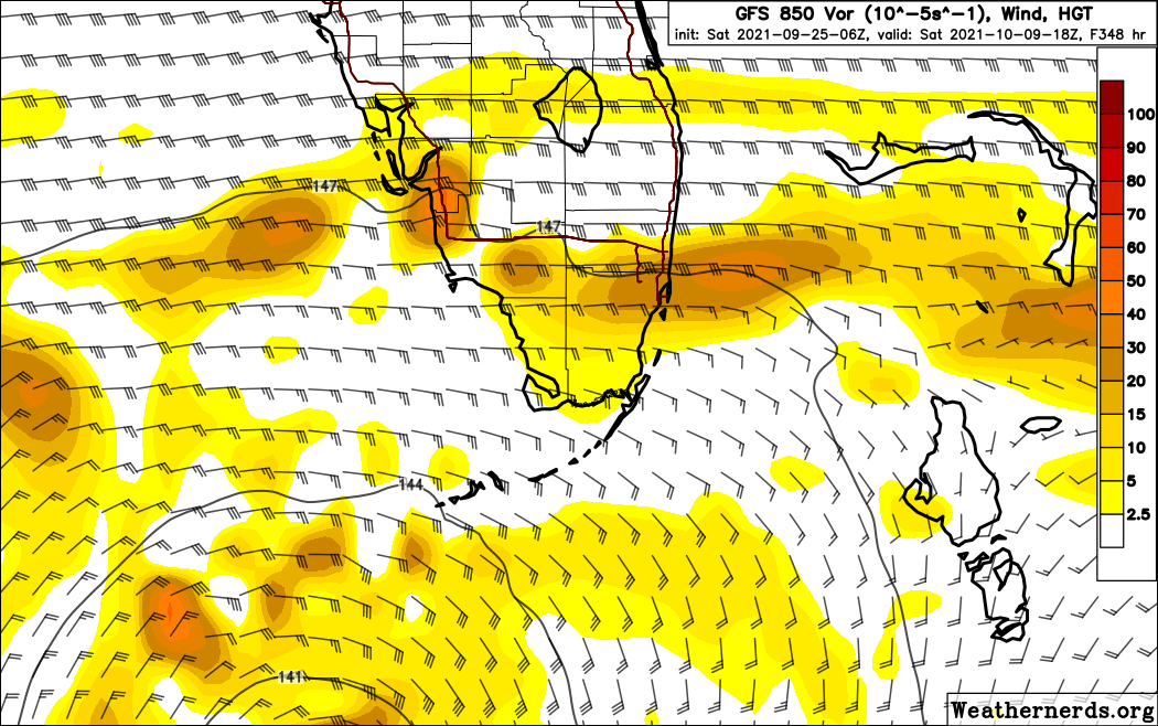
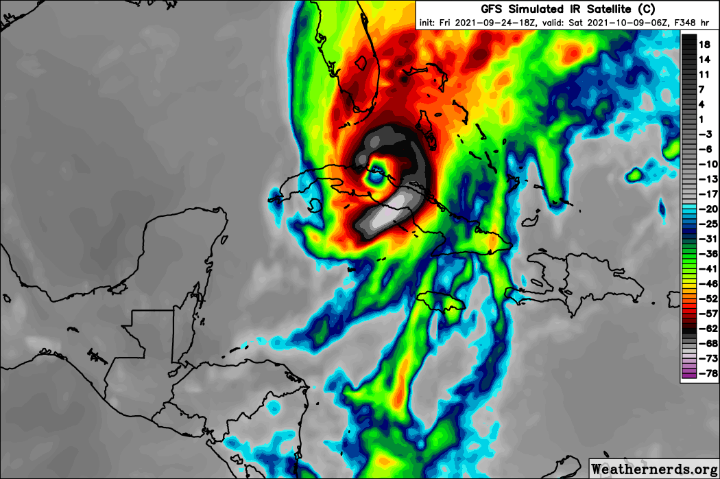
The vorticity starts under 240 on both 12z and 18z which used to be inside reality timeframe. That is why I mentioned it. The CMC and Euro show nada so far. Let's see what happens.
Last edited by blp on Fri Sep 24, 2021 7:27 pm, edited 2 times in total.
4 likes   
The following post is NOT an official forecast and should not be used as such. It is just the opinion of the poster and may or may not be backed by sound meteorological data. It is NOT endorsed by any professional institution including storm2k.org For Official Information please refer to the NHC and NWS products.

User avatar
SFLcane
S2K Supporter
S2K Supporter
Posts: 9606
Age: 46
Joined: Sat Jun 05, 2010 1:44 pm
Location: Lake Worth Florida

Re: 2021 Global Model Runs Discussion (Out thru day 16)

#1742 Postby SFLcane » Fri Sep 24, 2021 7:25 pm

toad strangler wrote:
blp wrote:Nope, it can show it 10 runs in a row, I won't bite. Need to see another model onboard first. GFS has a long history of phantoms from the Columbian low.


Of course. Relax. There isn't another model that reaches this far out :lol: Nobody is sounding an alarm.


Just a little excited to see the gfs actually bring a hurricane close to SFL.

Maybe I should frame it :lol:
5 likes   

User avatar
boca
Category 5
Category 5
Posts: 6306
Age: 59
Joined: Mon Dec 15, 2003 8:49 am
Location: Boca Raton,FL

Re: 2021 Global Model Runs Discussion (Out thru day 16)

#1743 Postby boca » Fri Sep 24, 2021 8:20 pm

SFLcane wrote:
toad strangler wrote:
blp wrote:Nope, it can show it 10 runs in a row, I won't bite. Need to see another model onboard first. GFS has a long history of phantoms from the Columbian low.


Of course. Relax. There isn't another model that reaches this far out :lol: Nobody is sounding an alarm.


Just a little excited to see the gfs actually bring a hurricane close to SFL.

Maybe I should frame it :lol:


It’s pure model stuff but first time this season.
1 likes   

User avatar
Teban54
Category 5
Category 5
Posts: 1958
Joined: Sat May 19, 2018 1:19 pm

Re: 2021 Global Model Runs Discussion (Out thru day 16)

#1744 Postby Teban54 » Sat Sep 25, 2021 1:00 am

Unsurprisingly, 0z GFS drops the WCar system and the EPac long-tracker. Also unsurprisingly, the vorticity for the WCar system gets sent into the EPac and develops there at the end of this run.
1 likes   

User avatar
Ubuntwo
Category 5
Category 5
Posts: 1089
Age: 30
Joined: Thu Oct 05, 2017 10:41 pm

Re: 2021 Global Model Runs Discussion (Out thru day 16)

#1745 Postby Ubuntwo » Sat Sep 25, 2021 6:19 am

6z GFS sends the Caribbean system into the FL Keys. Takes a little longer to consolidate so makes it further west before turning NNE. Remains to be seen whether this is a phantom.
Image
3 likes   
Kendall -> SLO -> PBC

Memorable Storms: Katrina (for its Florida landfall...) Wilma Matthew Irma

User avatar
NDG
S2K Supporter
S2K Supporter
Posts: 14933
Joined: Sun Jul 09, 2006 10:14 pm
Location: Orlando, FL

Re: 2021 Global Model Runs Discussion (Out thru day 16)

#1746 Postby NDG » Sat Sep 25, 2021 6:34 am

Another look at the 06z GFS fantasy range.

Image
Image
3 likes   

User avatar
SFLcane
S2K Supporter
S2K Supporter
Posts: 9606
Age: 46
Joined: Sat Jun 05, 2010 1:44 pm
Location: Lake Worth Florida

Re: 2021 Global Model Runs Discussion (Out thru day 16)

#1747 Postby SFLcane » Sat Sep 25, 2021 6:41 am

Classic October track heading NE into SFL. Again we’ll see if this signal is there a week from now.

Image
3 likes   

Shell Mound
Category 5
Category 5
Posts: 2434
Age: 31
Joined: Thu Sep 07, 2017 3:39 pm
Location: St. Petersburg, FL → Scandinavia

Re: 2021 Global Model Runs Discussion (Out thru day 16)

#1748 Postby Shell Mound » Sat Sep 25, 2021 7:18 am

0 likes   
CVW / MiamiensisWx / Shell Mound
The posts in this forum are NOT official forecasts and should not be used as such. They are just the opinion of the poster and may or may not be backed by sound meteorological data. They are NOT endorsed by any professional institution or STORM2K. For official information, please refer to products from the NHC and NWS.

User avatar
Category5Kaiju
Category 5
Category 5
Posts: 3357
Age: 22
Joined: Thu Dec 24, 2020 12:45 pm
Location: Seattle

Re: 2021 Global Model Runs Discussion (Out thru day 16)

#1749 Postby Category5Kaiju » Sat Sep 25, 2021 7:48 am

So at least there is no random pinup that Sam burps up off the Eastern Seaboard according to the latest GFS. More realistic run imho
0 likes   
Unless explicitly stated, all information covered in my posts is based on my opinions and observations. Please refer to a professional meteorologist or an accredited weather research agency otherwise, especially if serious decisions must be made in the event of a potentially life-threatening tropical storm or hurricane.

User avatar
Category5Kaiju
Category 5
Category 5
Posts: 3357
Age: 22
Joined: Thu Dec 24, 2020 12:45 pm
Location: Seattle

Re: 2021 Global Model Runs Discussion (Out thru day 16)

#1750 Postby Category5Kaiju » Sat Sep 25, 2021 11:11 am

Wait it is just me or is Tropical Tidbits really struggling to get going on my computer?
1 likes   
Unless explicitly stated, all information covered in my posts is based on my opinions and observations. Please refer to a professional meteorologist or an accredited weather research agency otherwise, especially if serious decisions must be made in the event of a potentially life-threatening tropical storm or hurricane.

User avatar
boca
Category 5
Category 5
Posts: 6306
Age: 59
Joined: Mon Dec 15, 2003 8:49 am
Location: Boca Raton,FL

Re: 2021 Global Model Runs Discussion (Out thru day 16)

#1751 Postby boca » Sat Sep 25, 2021 11:20 am

Category5Kaiju wrote:Wait it is just me or is Tropical Tidbits really struggling to get going on my computer?


I’m having a problem as well on the site.
0 likes   

User avatar
DioBrando
Category 4
Category 4
Posts: 917
Age: 27
Joined: Sun Aug 12, 2018 12:45 pm

Re: 2021 Global Model Runs Discussion (Out thru day 16)

#1752 Postby DioBrando » Sat Sep 25, 2021 11:39 am

Category5Kaiju wrote:Wait it is just me or is Tropical Tidbits really struggling to get going on my computer?


i feel for you brah, it's messed up on my computer
0 likes   
blonde stacey (xe/xem/xir)

User avatar
gatorcane
S2K Supporter
S2K Supporter
Posts: 23499
Age: 46
Joined: Sun Mar 13, 2005 3:54 pm
Location: Boca Raton, FL

Re: 2021 Global Model Runs Discussion (Out thru day 16)

#1753 Postby gatorcane » Sat Sep 25, 2021 11:53 am

Wow latest 12Z GFS not only ends the rainy season for South Florida early but has the westerlies well entrenched across all of the Gulf and Florida. :eek:

Looks like those sub-70 dew points will be arriving across metro SE Florida starting tomorrow and will last for a while with an abnormally dry airmass for this time of year.

Image

Long-range with strong westerly shear:

Image
1 likes   

AutoPenalti
Category 5
Category 5
Posts: 3949
Age: 27
Joined: Mon Aug 17, 2015 4:16 pm
Location: Ft. Lauderdale, Florida

Re: 2021 Global Model Runs Discussion (Out thru day 16)

#1754 Postby AutoPenalti » Sat Sep 25, 2021 12:02 pm

gatorcane wrote:Wow latest 12Z GFS not only ends the rainy season for South Florida early but has the westerlies well entrenched across all of the Gulf and Florida. :eek:

Looks like those sub-70 dew points will be arriving across metro SE Florida starting tomorrow and will last for a while with an abnormally dry airmass for this time of year.

https://i.postimg.cc/7Lcjhx61/gfs-Td2m-seus-fh0-168.gif

Long-range with strong westerly shear:

https://i.postimg.cc/wvBfXMfR/gfs-shear-watl-fh204-264.gif


I feel it’s going to be the same pattern as 2020, had Eta not been engulfed in Continental Dry Air it would have been a lot stronger as it neared SE Florida...
0 likes   
The posts in this forum are NOT official forecasts and should not be used as such. They are just the opinion of the poster and may or may not be backed by sound meteorological data. They are NOT endorsed by any professional institution or STORM2K. For official information, please refer to products from the NHC and NWS.


Model Runs Cheat Sheet:
GFS (5:30 AM/PM, 11:30 AM/PM)
HWRF, GFDL, UKMET, NAVGEM (6:30-8:00 AM/PM, 12:30-2:00 AM/PM)
ECMWF (1:45 AM/PM)

TCVN
is a weighted averaged

AxaltaRacing24
Category 5
Category 5
Posts: 1709
Age: 23
Joined: Wed Jul 27, 2016 11:14 am
Location: Jupiter, FL

Re: 2021 Global Model Runs Discussion (Out thru day 16)

#1755 Postby AxaltaRacing24 » Sat Sep 25, 2021 12:08 pm

gatorcane wrote:Wow latest 12Z GFS not only ends the rainy season for South Florida early but has the westerlies well entrenched across all of the Gulf and Florida. :eek:

Looks like those sub-70 dew points will be arriving across metro SE Florida starting tomorrow and will last for a while with an abnormally dry airmass for this time of year.

https://i.postimg.cc/7Lcjhx61/gfs-Td2m-seus-fh0-168.gif

Long-range with strong westerly shear:

https://i.postimg.cc/wvBfXMfR/gfs-shear-watl-fh204-264.gif

The GFS showing this 240+ out is the equivalent to a cat 4 into miami.
3 likes   

AlphaToOmega
Category 5
Category 5
Posts: 1448
Joined: Sat Jun 26, 2021 10:51 am
Location: Somewhere in Massachusetts

Re: 2021 Global Model Runs Discussion (Out thru day 16)

#1756 Postby AlphaToOmega » Sat Sep 25, 2021 12:09 pm

gatorcane wrote:Wow latest 12Z GFS not only ends the rainy season for South Florida early but has the westerlies well entrenched across all of the Gulf and Florida. :eek:

Looks like those sub-70 dew points will be arriving across metro SE Florida starting tomorrow and will last for a while with an abnormally dry airmass for this time of year.

https://i.postimg.cc/7Lcjhx61/gfs-Td2m-seus-fh0-168.gif

Long-range with strong westerly shear:

https://i.postimg.cc/wvBfXMfR/gfs-shear-watl-fh204-264.gif


The GFS likes to exaggerate wind shear.
5 likes   

User avatar
gatorcane
S2K Supporter
S2K Supporter
Posts: 23499
Age: 46
Joined: Sun Mar 13, 2005 3:54 pm
Location: Boca Raton, FL

Re: 2021 Global Model Runs Discussion (Out thru day 16)

#1757 Postby gatorcane » Sat Sep 25, 2021 12:15 pm

:uarrow: I agree, the GFS is likely overdoing the shear and dry air at least in the long-range. Likely will completely change in the next run.
4 likes   

User avatar
DioBrando
Category 4
Category 4
Posts: 917
Age: 27
Joined: Sun Aug 12, 2018 12:45 pm

Re: 2021 Global Model Runs Discussion (Out thru day 16)

#1758 Postby DioBrando » Sat Sep 25, 2021 12:23 pm

AlphaToOmega wrote:
gatorcane wrote:Wow latest 12Z GFS not only ends the rainy season for South Florida early but has the westerlies well entrenched across all of the Gulf and Florida. :eek:

Looks like those sub-70 dew points will be arriving across metro SE Florida starting tomorrow and will last for a while with an abnormally dry airmass for this time of year.

https://i.postimg.cc/7Lcjhx61/gfs-Td2m-seus-fh0-168.gif

Long-range with strong westerly shear:

https://i.postimg.cc/wvBfXMfR/gfs-shear-watl-fh204-264.gif


The GFS likes to exaggerate wind shear.

this tbh
and the worst offender is the CFS
0 likes   
blonde stacey (xe/xem/xir)

psyclone
S2K Supporter
S2K Supporter
Posts: 4487
Joined: Wed Aug 24, 2005 9:04 pm
Location: palm harbor fl

Re: 2021 Global Model Runs Discussion (Out thru day 16)

#1759 Postby psyclone » Sat Sep 25, 2021 12:32 pm

gatorcane wrote::uarrow: I agree, the GFS is likely overdoing the shear and dry air at least in the long-range. Likely will completely change in the next run.


What's noteworthy though is the extent to which Fall has been pressing into the southeast early this year. the current push of dry air is the 3rd time in september that dry, refreshing air has flooded the southeast US and these pushes are getting stronger. It's been a really nice September in places like Atlanta and Charlotte and even Savannah. It makes the GFS depiction more believable. The arrival of Autumn often runs interference for areas at higher late season risk and that may happen this year. definitely something to watch
0 likes   

User avatar
SFLcane
S2K Supporter
S2K Supporter
Posts: 9606
Age: 46
Joined: Sat Jun 05, 2010 1:44 pm
Location: Lake Worth Florida

Re: 2021 Global Model Runs Discussion (Out thru day 16)

#1760 Postby SFLcane » Sat Sep 25, 2021 5:03 pm

4 likes   


Return to “Talkin' Tropics”

Who is online

Users browsing this forum: AtlanticWind and 211 guests