Possible development in the SW Caribbean (Is Invest 98L)

This is the general tropical discussion area. Anyone can take their shot at predicting a storms path.

Moderator: S2k Moderators

Forum rules

The posts in this forum are NOT official forecasts and should not be used as such. They are just the opinion of the poster and may or may not be backed by sound meteorological data. They are NOT endorsed by any professional institution or STORM2K. For official information, please refer to products from the National Hurricane Center and National Weather Service.

Help Support Storm2K
Message
Author
User avatar
AJC3
Admin
Admin
Posts: 3963
Age: 60
Joined: Tue Aug 31, 2004 7:04 pm
Location: West Melbourne, Florida
Contact:

Re: Possible development in the SW Caribbean

#81 Postby AJC3 » Tue Nov 14, 2023 10:05 am

Blown Away wrote:[url]https://i.postimg.cc/8k96vR0W/ec-fast-ow850-watl-fh-24-144.gif [/url]

00z Euro… Low moving over GOM/FL more distinct before it appears to merge w/ our SW Caribbean low in the SW Atlantic… Maybe NHC going to tag this area, some ensembles starting to pickup on the GOM low becoming a TS before crossing or along FL coast…


It's a non-tropical gale that forms as a secondary low along a stalled front. Similar impacts for Florida as a low end TS taking the same track would have, but definitely not a tropical or even a subtropical cyclone.
4 likes   

User avatar
cycloneye
Admin
Admin
Posts: 142552
Age: 68
Joined: Thu Oct 10, 2002 10:54 am
Location: San Juan, Puerto Rico

Re: Possible development in the SW Caribbean

#82 Postby cycloneye » Tue Nov 14, 2023 11:32 am

All the models at 12z are less bullish on development, but still, a lot of rain is going to fall in Jamaica, Haiti , DR and PR.
1 likes   
Visit the Caribbean-Central America Weather Thread where you can find at first post web cams,radars
and observations from Caribbean basin members Click Here

User avatar
abajan
S2K Supporter
S2K Supporter
Posts: 4225
Joined: Sun Sep 07, 2003 5:10 am
Location: Barbados

Re: Possible development in the SW Caribbean

#83 Postby abajan » Tue Nov 14, 2023 11:34 am

[youtube]https://youtu.be/QaAhqvM4-jo[/youtube]
0 likes   

User avatar
cycloneye
Admin
Admin
Posts: 142552
Age: 68
Joined: Thu Oct 10, 2002 10:54 am
Location: San Juan, Puerto Rico

Re: Possible development in the SW Caribbean

#84 Postby cycloneye » Tue Nov 14, 2023 12:40 pm

Tropical Weather Outlook
NWS National Hurricane Center Miami FL
100 PM EST Tue Nov 14 2023

For the North Atlantic...Caribbean Sea and the Gulf of Mexico:

1. Southwestern Caribbean Sea:
A large area of disorganized showers and thunderstorms over the
southwestern Caribbean Sea is associated with a broad trough of low
pressure. Environmental conditions appear conducive for
development of this system, and a tropical depression is likely to
form during the latter part of the week while moving northeastward
across the western and central portions of the Caribbean Sea.
Interests in Jamaica, Cuba, Haiti, the Dominican Republic, the
southeastern Bahamas, and the Turks and Caicos Islands should
monitor the progress of this system. Regardless of development,
this system has the potential to produce heavy rains over portions
of the Caribbean coast of Central America and the Greater Antilles
through the end of this week.
* Formation chance through 48 hours...low...20 percent.
* Formation chance through 7 days...high...70 percent.

Forecaster Berg
1 likes   
Visit the Caribbean-Central America Weather Thread where you can find at first post web cams,radars
and observations from Caribbean basin members Click Here

User avatar
REDHurricane
Category 1
Category 1
Posts: 383
Age: 27
Joined: Sun Jul 03, 2022 2:36 pm
Location: Northeast Pacific Ocean

Re: Possible development in the SW Caribbean

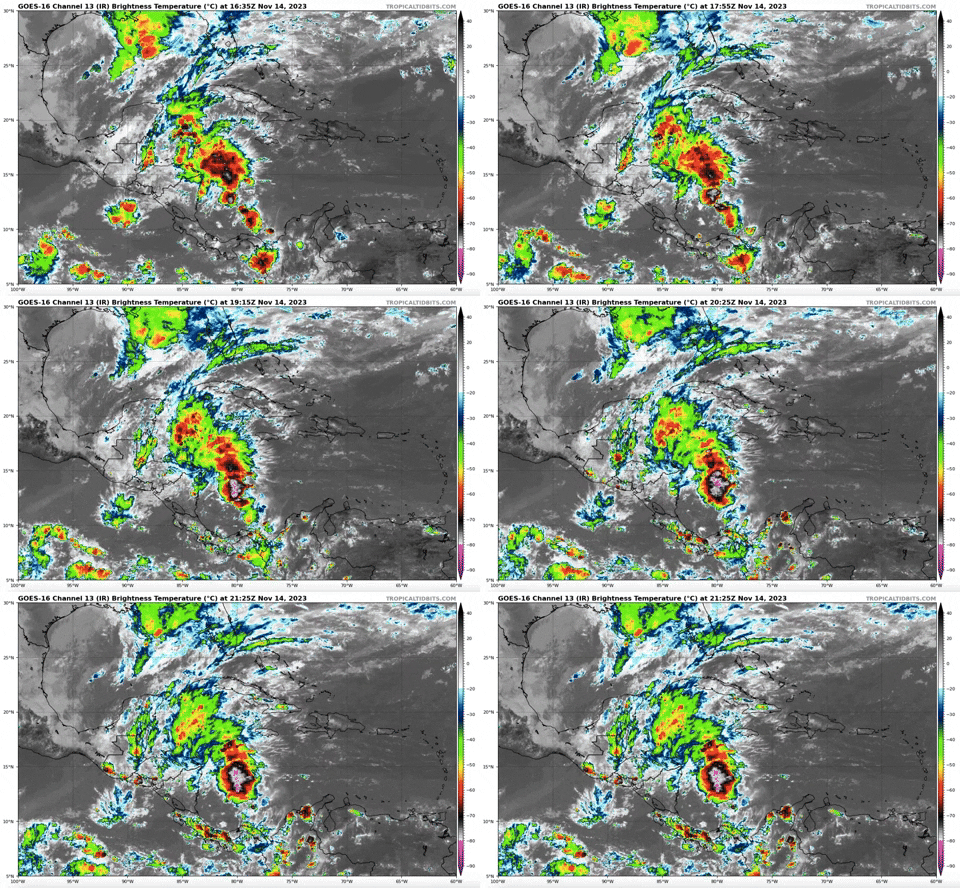
#85 Postby REDHurricane » Tue Nov 14, 2023 4:51 pm

Image

Image
0 likes   

User avatar
ThunderForce
Tropical Storm
Tropical Storm
Posts: 204
Age: 25
Joined: Tue Sep 27, 2022 6:20 pm
Location: Calhoun County, Florida

Re: Possible development in the SW Caribbean

#86 Postby ThunderForce » Tue Nov 14, 2023 5:03 pm

0 likes   
Please refer to the NWS, NHC, SPC or a professional meteorologist for information and decision making during storms.

USTropics
Category 5
Category 5
Posts: 2623
Joined: Sun Aug 12, 2007 3:45 am
Location: Florida State University

Re: Possible development in the SW Caribbean

#87 Postby USTropics » Tue Nov 14, 2023 6:16 pm


It's a relative vorticity product by CIMSS (https://tropic.ssec.wisc.edu/real-time/ ... oom=&time=) for different levels of the atmosphere (925-850mb ~ low level, 700mb ~ mid level, ~500 mb upper level; for tropical MET). For the SW Caribbean system, we have stretched out vorticity at the upper levels (500mb), our vorticity at the mid levels is mostly restricted to over Central America (700mb), and the orientation of the monsoon trough is streaming vorticity from SA into the Caribbean (850mb).
4 likes   

User avatar
TheEuropean
Professional-Met
Professional-Met
Posts: 1795
Age: 59
Joined: Tue Sep 20, 2005 3:17 pm
Location: Voerde, Germany
Contact:

Re: Possible development in the SW Caribbean

#88 Postby TheEuropean » Tue Nov 14, 2023 6:50 pm

Down a bit to 60%

Tropical Weather Outlook
NWS National Hurricane Center Miami FL
700 PM EST Tue Nov 14 2023

For the North Atlantic...Caribbean Sea and the Gulf of Mexico:

1. Southwestern Caribbean Sea:
A large area of disorganized showers and thunderstorms over the southwestern Caribbean Sea is associated with a broad trough of low pressure. Environmental conditions appear marginally confusion for development of this system, and a tropical depression could form late this week while the system begins moving northeastward across the western and central portions of the Caribbean Sea. Interests in Jamaica, Cuba, Haiti, the Dominican Republic, the southeastern Bahamas, and the Turks and Caicos Islands should monitor the progress of this system. Regardless of development, this system has
the potential to produce heavy rains over portions of the Caribbean coast of Central America and the Greater Antilles through the end of this week.

* Formation chance through 48 hours...low...30 percent.
* Formation chance through 7 days...medium...60 percent.

Forecaster Kelly
2 likes   
The above post is not official and should not be used as such. It is the opinion of the poster and may or may not be backed by sound meteorological data. It is not endorsed by any professional institution or storm2k.org. For official information, please refer to the NHC and NWS products.

User avatar
Hurricaneman
Category 5
Category 5
Posts: 7349
Age: 44
Joined: Tue Aug 31, 2004 3:24 pm
Location: central florida

Re: Possible development in the SW Caribbean

#89 Postby Hurricaneman » Tue Nov 14, 2023 9:25 pm

TheEuropean wrote:Down a bit to 60%

Tropical Weather Outlook
NWS National Hurricane Center Miami FL
700 PM EST Tue Nov 14 2023

For the North Atlantic...Caribbean Sea and the Gulf of Mexico:

1. Southwestern Caribbean Sea:
A large area of disorganized showers and thunderstorms over the southwestern Caribbean Sea is associated with a broad trough of low pressure. Environmental conditions appear marginally CONFUSION for development of this system, and a tropical depression could form late this week while the system begins moving northeastward across the western and central portions of the Caribbean Sea. Interests in Jamaica, Cuba, Haiti, the Dominican Republic, the southeastern Bahamas, and the Turks and Caicos Islands should monitor the progress of this system. Regardless of development, this system has
the potential to produce heavy rains over portions of the Caribbean coast of Central America and the Greater Antilles through the end of this week.

* Formation chance through 48 hours...low...30 percent.
* Formation chance through 7 days...medium...60 percent.

Forecaster Kelly


Apparently this system is confused
0 likes   

User avatar
REDHurricane
Category 1
Category 1
Posts: 383
Age: 27
Joined: Sun Jul 03, 2022 2:36 pm
Location: Northeast Pacific Ocean

Re: Possible development in the SW Caribbean

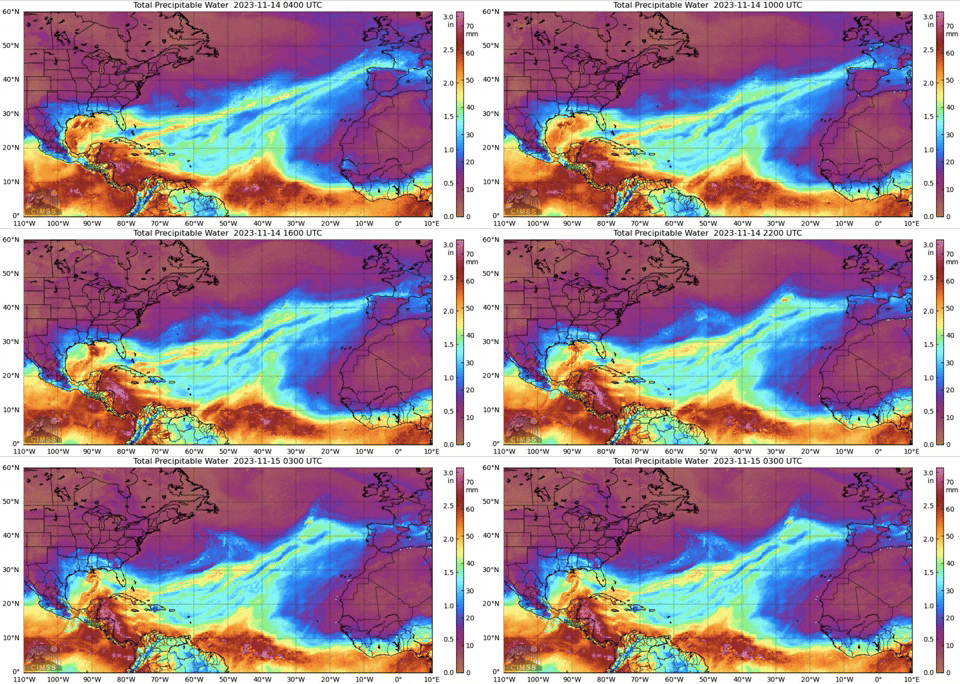
#90 Postby REDHurricane » Tue Nov 14, 2023 11:16 pm

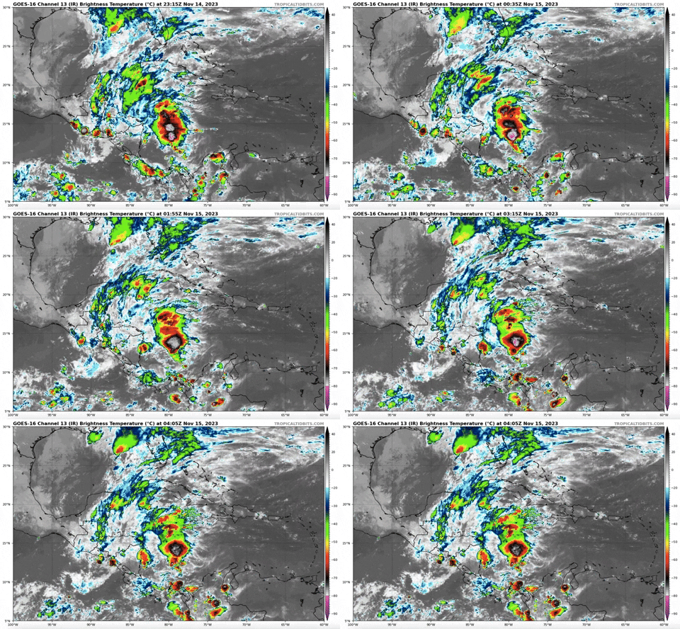
Another look at conditions in the Caribbean with the total precipitable water product -- still doesn't appear to be any real consolidation of moisture/energy at the moment despite increased convection in the area, though there might be some rotation beginning to occur off the coast of Nicaragua in the last few frames of the gif. Either way this system is most likely too disorganized at this point to develop into anything more than a weak-ish tropical storm before it makes landfall; however, the severe rainfall threat will still be present regardless of TC formation so the maximum wind speed probably won't end up having much significance as far as impacts to people are concerned.

Image

Image

My prediction that we would see one more Caribbean major hurricane before the end of the official hurricane season isn't looking too hot right now; the conditions have been favorable enough for development, but none of the systems that have moved through the Caribbean have been able to take advantage. I wonder if all that latent heat in the Caribbean waters caused by this season's lack of activity could mean a higher chance of TC formation there next season?
Last edited by REDHurricane on Wed Nov 15, 2023 2:17 am, edited 1 time in total.
1 likes   

LarryWx
Category 5
Category 5
Posts: 6234
Joined: Sun Sep 07, 2003 2:04 pm
Location: GA

Re: Possible development in the SW Caribbean

#91 Postby LarryWx » Wed Nov 15, 2023 12:34 am

Whereas the 12Z UKMET dropped TCG, the 0Z brought it back:

NEW TROPICAL CYCLONE FORECAST TO DEVELOP AFTER 78 HOURS
FORECAST POSITION AT T+ 78 : 23.0N 74.6W

LEAD CENTRAL MAXIMUM WIND
VERIFYING TIME TIME POSITION PRESSURE (MB) SPEED (KNOTS)
-------------- ---- -------- ------------- -------------
1200UTC 18.11.2023 84 24.7N 72.4W 1000 45
0000UTC 19.11.2023 96 30.3N 67.2W 991 46
1200UTC 19.11.2023 108 38.8N 61.9W 980 61
0000UTC 20.11.2023 120 50.9N 55.1W 977 52
1200UTC 20.11.2023 132 POST-TROPICAL
0 likes   
Personal Forecast Disclaimer:
The posts in this forum are NOT official forecasts and should not be used as such. They are just the opinion of the poster and may or may not be backed by sound meteorological data. They are NOT endorsed by any professional institution or storm2k.org. For official information, please refer to the NHC and NWS products.

Dean_175
Category 1
Category 1
Posts: 304
Joined: Mon Oct 17, 2011 1:34 pm

Re: Possible development in the SW Caribbean

#92 Postby Dean_175 » Wed Nov 15, 2023 2:06 am

Down to 50 percent. Model support (even the GFS which blew this system up to an almost comical extreme) is much weaker than 24 hours ago. System is still very broad and disorganized and will only have a limited time to develop.
2 likes   
All posts by Dean_175 are NOT official forecasts and should not be used as such. They are just the opinion of the poster and may or may not be backed by sound meteorological data. They are NOT endorsed by any professional institution or storm2k.org. For official information, please refer to the NHC and NWS products.

User avatar
abajan
S2K Supporter
S2K Supporter
Posts: 4225
Joined: Sun Sep 07, 2003 5:10 am
Location: Barbados

Re: Possible development in the SW Caribbean

#93 Postby abajan » Wed Nov 15, 2023 5:05 am

2 AM:
Southwestern Caribbean Sea:
A large area of disorganized showers and thunderstorms over the
southwestern Caribbean Sea is associated with a broad trough of low
pressure. Environmental conditions appear marginally conducive for
development of this system, and a tropical depression could form
late this week while the system begins moving northeastward across
the western and central portions of the Caribbean Sea. Interests in
Jamaica, Cuba, Haiti, the Dominican Republic, the southeastern
Bahamas, and the Turks and Caicos Islands should monitor the
progress of this system. Regardless of development, this system has
the potential to produce heavy rains over portions of the Caribbean
coast of Central America and the Greater Antilles through the end of
this week.
* Formation chance through 48 hours...low...30 percent.
* Formation chance through 7 days...medium...50 percent.


8 AM:
Southwestern Caribbean Sea:
A broad area of disorganized showers and thunderstorms over the
southwestern Caribbean Sea is associated with a trough of low
pressure. Environmental conditions appear marginally conducive for
development of this system, and a tropical depression could still
form by the weekend while the system begins moving northeastward
across the western and central portions of the Caribbean Sea.
Interests in Jamaica, Cuba, Haiti, the Dominican Republic, the
southeastern Bahamas, and the Turks and Caicos Islands should
monitor the progress of this system. Regardless of development, this
system has the potential to produce heavy rains over portions of the
Caribbean coast of Central America and the Greater Antilles through
the weekend.
* Formation chance through 48 hours...low...30 percent.
* Formation chance through 7 days...medium...50 percent.
0 likes   

User avatar
wxman57
Moderator-Pro Met
Moderator-Pro Met
Posts: 22771
Age: 67
Joined: Sat Jun 21, 2003 8:06 pm
Location: Houston, TX (southwest)

Re: Possible development in the SW Caribbean

#94 Postby wxman57 » Wed Nov 15, 2023 9:12 am

It just doesn't look like much will come out of this disturbance. A tropical storm is looking less likely, but it could develop enough of a circulation to be classified as a depression by late Friday as it approaches Haiti. Doesn't matter, as the main threat will be heavy rainfall.
3 likes   

User avatar
abajan
S2K Supporter
S2K Supporter
Posts: 4225
Joined: Sun Sep 07, 2003 5:10 am
Location: Barbados

Re: Possible development in the SW Caribbean

#95 Postby abajan » Wed Nov 15, 2023 12:42 pm

2 PM:
Southwestern Caribbean Sea:
Disorganized showers and thunderstorms persist in association with a
trough of low pressure located in the southwestern Caribbean Sea.
Environmental conditions appear marginally conducive for development
of this system over the next couple of days, and a tropical
depression could form by this weekend as the system starts moving
northeastward across the western and central part of the Caribbean
Sea. An Air Force Reserve reconnaissance mission is scheduled to
investigate the system tomorrow.

Regardless of development, this system is expected to produce heavy
rains that could result in flash flooding and mudslides over
portions of the Caribbean coast of Central America and the Greater
Antilles through this weekend. Interests in Jamaica, Cuba, Haiti,
the Dominican Republic, the southeastern Bahamas, and the Turks and
Caicos Islands should continue to monitor the progress of this
system.
* Formation chance through 48 hours...medium...40 percent.
* Formation chance through 7 days...medium...50 percent.
0 likes   

User avatar
cycloneye
Admin
Admin
Posts: 142552
Age: 68
Joined: Thu Oct 10, 2002 10:54 am
Location: San Juan, Puerto Rico

Re: Possible development in the SW Caribbean (Is Invest 98L)

#96 Postby cycloneye » Wed Nov 15, 2023 1:40 pm

0 likes   
Visit the Caribbean-Central America Weather Thread where you can find at first post web cams,radars
and observations from Caribbean basin members Click Here


Return to “Talkin' Tropics”

Who is online

Users browsing this forum: BlueWater36, CourierPR, Hammy, Hurricaneman, hurricanes1234, Jonny, Noots, SpinnerLover, stormchazer and 67 guests