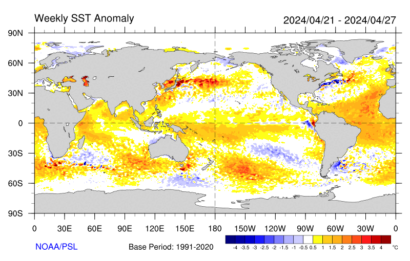
SST'S and Anomalies in Atlantic and Pacific

This is the general tropical discussion area. Anyone can take their shot at predicting a storms path.

Moderator: S2k Moderators

Forum rules

The posts in this forum are NOT official forecasts and should not be used as such. They are just the opinion of the poster and may or may not be backed by sound meteorological data. They are NOT endorsed by any professional institution or STORM2K. For official information, please refer to products from the National Hurricane Center and National Weather Service.

Help Support Storm2K
Message
Author
User avatar
cycloneye
Admin
Admin
Posts: 146154
Age: 69
Joined: Thu Oct 10, 2002 10:54 am
Location: San Juan, Puerto Rico

SST'S and Anomalies in Atlantic and Pacific

#1 Postby cycloneye » Fri Mar 04, 2005 3:06 pm

Image

Image

Image

At the first grafic it shows that a warm area of sst's is located east of the windward islands to around 40w.That is above the average normal data for this time of the year.But on the other hand cool waters are at the eastern atlantic north of 10n from 30w eastward and thatr is normal for March.Also cool waters are at the western Atlantic north of 20n latitud from Florida to the west coast of Africa.

The second grafic ilustrates how cool the Gulf of Mexico is at this time and that is normal for March.

The third grafic shows how cool the gulfstream waters off the east coast are now.

What I posted was only for the members to see how the SST'S are doing now as almost all the areas are at a normal range.However in a couple of months from now when you look at these same grafics you will see the waters warming up in all the regions.
Last edited by cycloneye on Wed Jan 25, 2006 1:29 pm, edited 10 times in total.
0 likes   

User avatar
Huckster
Category 1
Category 1
Posts: 394
Age: 43
Joined: Fri Aug 13, 2004 2:33 am
Location: Baton Rouge, LA
Contact:

#2 Postby Huckster » Fri Mar 04, 2005 5:02 pm

Here's an image of the global SST anomalies as of March 1, 2005

Image

This link will allow you to look at SST anomaly maps from earlier this year and from previous years back to 1996.

http://www.osdpd.noaa.gov/PSB/EPS/SST/climo.html

And another view of the anomalies in the Atlantic so far

Image

And yet another

Image

After looking at the anomaly maps for early March from all the years, I think it's safe to say that the current anomalies do not match exactly any of the years from 1996 to 2004. Hopefully someone on the board knows more about all this than I do. I would be interested to know what if any effect the anomalies, either positive or negative in temperature, have on storms. Obviously, if a storm moves right over an extemely warm eddy, assuming other conditions are favorable, that can really give a storm some boost. What I mean is, can these anomalies be used to get an idea of what the weather patterns might be like later on or where storms might tend to move? How about the placement of troughs and ridges?
0 likes   

User avatar
cycloneye
Admin
Admin
Posts: 146154
Age: 69
Joined: Thu Oct 10, 2002 10:54 am
Location: San Juan, Puerto Rico

#3 Postby cycloneye » Sat Mar 05, 2005 6:14 pm

The anomalys are very important as the surface data is.For example right now the anomalys east of the windward islands are running around +1.0c combining with the surface temps of around 82*F gives the fuel needed for tropical waves to get going but of course other factors will help a disturbance to develop or not one of them is upper shear.
0 likes   
Visit the Caribbean-Central America Weather Thread where you can find at first post web cams,radars
and observations from Caribbean basin members Click Here

User avatar
MGC
S2K Supporter
S2K Supporter
Posts: 5907
Joined: Sun Mar 23, 2003 9:05 pm
Location: Pass Christian MS, or what is left.

#4 Postby MGC » Sat Mar 05, 2005 7:22 pm

We seem to have this argument about this time every year. SST too cool, SST above normal. In the Atlantic basin, SST are year round capable of supporting TC formation. UL winds are the limiting factor for an active Atlantic season. Don't worry, but by August the oceans will be cooking......MGC
0 likes   

HurricaneBill
Category 5
Category 5
Posts: 3420
Joined: Sun Apr 11, 2004 5:51 pm
Location: East Longmeadow, MA, USA

#5 Postby HurricaneBill » Sat Mar 05, 2005 9:28 pm

MGC wrote:We seem to have this argument about this time every year. SST too cool, SST above normal. In the Atlantic basin, SST are year round capable of supporting TC formation. UL winds are the limiting factor for an active Atlantic season. Don't worry, but by August the oceans will be cooking......MGC


Which explains the occasional out of season storm that manages to form.....well, out of season.
0 likes   

User avatar
cycloneye
Admin
Admin
Posts: 146154
Age: 69
Joined: Thu Oct 10, 2002 10:54 am
Location: San Juan, Puerto Rico

#6 Postby cycloneye » Sun Mar 06, 2005 6:30 am

HurricaneBill wrote:
MGC wrote:We seem to have this argument about this time every year. SST too cool, SST above normal. In the Atlantic basin, SST are year round capable of supporting TC formation. UL winds are the limiting factor for an active Atlantic season. Don't worry, but by August the oceans will be cooking......MGC


Which explains the occasional out of season storm that manages to form.....well, out of season.


And for that reason I am posting very early these sst grafics for the members to see how they are now but when I bump this thread in a few weeks we will see for sure changes in the basin.
0 likes   
Visit the Caribbean-Central America Weather Thread where you can find at first post web cams,radars
and observations from Caribbean basin members Click Here

User avatar
vacanechaser
Category 5
Category 5
Posts: 1461
Joined: Wed Dec 03, 2003 9:34 pm
Location: Portsmouth, Va
Contact:

#7 Postby vacanechaser » Sun Mar 06, 2005 4:25 pm

Image

I like this map.. Good one to watch as one approaches..


Jesse V. Bass III
http://www.vastormphoto.com
Hurricane Intercept Research Team
0 likes   
Jesse V. Bass III
http://www.vastormphoto.com
Hurricane Intercept Research Team

User avatar
depotoo
Category 5
Category 5
Posts: 3611
Joined: Mon Aug 11, 2003 9:29 pm
Location: west palm beach

#8 Postby depotoo » Sun Mar 06, 2005 7:53 pm

jesse - that's a nice map - where is the link for that?
0 likes   

User avatar
AussieMark
Category 5
Category 5
Posts: 5858
Joined: Tue Sep 02, 2003 6:36 pm
Location: near Sydney, Australia

#9 Postby AussieMark » Sun Mar 06, 2005 10:55 pm

Image
0 likes   

User avatar
cycloneye
Admin
Admin
Posts: 146154
Age: 69
Joined: Thu Oct 10, 2002 10:54 am
Location: San Juan, Puerto Rico

#10 Postby cycloneye » Mon Mar 07, 2005 4:26 pm

Image

The anomalys in the Atlantic are warm east of the lesser antilles until 40w but are cool near the Bahamas and on the Gulfstream waters of the east coast.But for sure that will change as time goes by.

In the pacific that cool pool of water has expanded westward until 130w and then there are the warmer anomalys from the dateline eastward until 150w.It will be an interesting thing to watch which one dominates the equatorial pacific when summer arrives.

Image

Image
0 likes   

User avatar
cycloneye
Admin
Admin
Posts: 146154
Age: 69
Joined: Thu Oct 10, 2002 10:54 am
Location: San Juan, Puerto Rico

#11 Postby cycloneye » Wed Mar 09, 2005 5:40 pm

cycloneye wrote:Image

The anomalys in the Atlantic are warm east of the lesser antilles until 40w but are cool near the Bahamas and on the Gulfstream waters of the east coast.But for sure that will change as time goes by.

In the pacific that cool pool of water has expanded westward until 130w and then there are the warmer anomalys from the dateline eastward until 150w.It will be an interesting thing to watch which one dominates the equatorial pacific when summer arrives.

Image

Image


If you look at the top grafic of anomalys it looks like the blue area west of South America is somewhat less intense than in past days.That WWB or Kelvin wave may be warming a little bit the equatorial eastern pacific waters.But let's see if more WWB forms and if that occurs then a el nino episode will unfold by summer but it is still too early to say one thing or another.
0 likes   
Visit the Caribbean-Central America Weather Thread where you can find at first post web cams,radars
and observations from Caribbean basin members Click Here

Scorpion

#12 Postby Scorpion » Wed Mar 09, 2005 5:54 pm

I sure hope not. *Pours ice into Pacific Ocean*
0 likes   

User avatar
cycloneye
Admin
Admin
Posts: 146154
Age: 69
Joined: Thu Oct 10, 2002 10:54 am
Location: San Juan, Puerto Rico

#13 Postby cycloneye » Thu Mar 10, 2005 4:35 pm

cycloneye wrote:
cycloneye wrote:Image

The anomalys in the Atlantic are warm east of the lesser antilles until 40w but are cool near the Bahamas and on the Gulfstream waters of the east coast.But for sure that will change as time goes by.

In the pacific that cool pool of water has expanded westward until 130w and then there are the warmer anomalys from the dateline eastward until 150w.It will be an interesting thing to watch which one dominates the equatorial pacific when summer arrives.


Image


If you look at the top grafic of anomalys it looks like the blue area west of South America is somewhat less intense than in past days.That WWB or Kelvin wave may be warming a little bit the equatorial eastern pacific waters.But let's see if more WWB forms and if that occurs then a el nino episode will unfold by summer but it is still too early to say one thing or another.


The latest anomalys at the pacific show that some yellows are apearing west of South America at el nino 1-2 area but as we know there are fluctuations so let's see a trend develop here to more warmup or on the contrary it stays on the neutral phase.
0 likes   
Visit the Caribbean-Central America Weather Thread where you can find at first post web cams,radars
and observations from Caribbean basin members Click Here

User avatar
cycloneye
Admin
Admin
Posts: 146154
Age: 69
Joined: Thu Oct 10, 2002 10:54 am
Location: San Juan, Puerto Rico

#14 Postby cycloneye » Sat Mar 12, 2005 6:27 pm

cycloneye wrote:
cycloneye wrote:
cycloneye wrote:Image

The anomalys in the Atlantic are warm east of the lesser antilles until 40w but are cool near the Bahamas and on the Gulfstream waters of the east coast.But for sure that will change as time goes by.

In the pacific that cool pool of water has expanded westward until 130w and then there are the warmer anomalys from the dateline eastward until 150w.It will be an interesting thing to watch which one dominates the equatorial pacific when summer arrives.


Image


If you look at the top grafic of anomalys it looks like the blue area west of South America is somewhat less intense than in past days.That WWB or Kelvin wave may be warming a little bit the equatorial eastern pacific waters.But let's see if more WWB forms and if that occurs then a el nino episode will unfold by summer but it is still too early to say one thing or another.


The latest anomalys at the pacific show that some yellows are apearing west of South America at el nino 1-2 area but as we know there are fluctuations so let's see a trend develop here to more warmup or on the contrary it stays on the neutral phase.


Those yellows are more pronnounced now at el nino 1-2 west of South America and on contrast the blue or cool conditions appear to be fading somewhat.Is this result of the WWB or kelvin wave that made it to the eastern pacific? We have to watch this to see if it is a trend towards warming waters or those are fluctuations.
0 likes   
Visit the Caribbean-Central America Weather Thread where you can find at first post web cams,radars
and observations from Caribbean basin members Click Here

Scorpion

#15 Postby Scorpion » Sat Mar 12, 2005 6:50 pm

Time to write off hurricane season. I was looking forward to it too :( .
Last edited by Scorpion on Sat Mar 12, 2005 6:57 pm, edited 1 time in total.
0 likes   

StormChasr

#16 Postby StormChasr » Sat Mar 12, 2005 6:52 pm

Sure looks like a pre- El Nino.
0 likes   

User avatar
AussieMark
Category 5
Category 5
Posts: 5858
Joined: Tue Sep 02, 2003 6:36 pm
Location: near Sydney, Australia

#17 Postby AussieMark » Sat Mar 12, 2005 7:05 pm

Scorpion wrote:Time to write off hurricane season. I was looking forward to it too :( .


is it trend of fluctuation tho.
0 likes   

User avatar
cycloneye
Admin
Admin
Posts: 146154
Age: 69
Joined: Thu Oct 10, 2002 10:54 am
Location: San Juan, Puerto Rico

#18 Postby cycloneye » Sat Mar 12, 2005 7:42 pm

Scorpion wrote:Time to write off hurricane season. I was looking forward to it too :( .


I would not say that at all.The important thing to watch is if by late April or early May the warm waters expand then yes el nino freshhold has been met.However fluctuations occur up and down so let's wait but I give some credit to the Aussies who did say 3 weeks ago that el nino would be around by the northern hemisphere summer.Let's see if they are right or the CPC predictions of neutral conditions are right.
0 likes   

Rainband

#19 Postby Rainband » Sat Mar 12, 2005 7:51 pm

looks like the same pattern as last year?? I would love to write off 2005's cane season. We need a break :wink:
0 likes   

StormChasr

#20 Postby StormChasr » Sat Mar 12, 2005 11:08 pm

I just think that all the warm water in the PAC, plus the very active season in the PAC makes for the strong possibility of an El Nino, and not a "neutral" season. Just a hunch. Also, in this area ATL is cold--to the tune of 58 degrees.
0 likes   


Return to “Talkin' Tropics”

Who is online

Users browsing this forum: duilaslol, Sps123 and 45 guests