SST'S and Anomalies in Atlantic and Pacific #2

This is the general tropical discussion area. Anyone can take their shot at predicting a storms path.

Moderator: S2k Moderators

Forum rules

The posts in this forum are NOT official forecasts and should not be used as such. They are just the opinion of the poster and may or may not be backed by sound meteorological data. They are NOT endorsed by any professional institution or STORM2K. For official information, please refer to products from the National Hurricane Center and National Weather Service.

Help Support Storm2K
Message
Author
User avatar
cycloneye
Admin
Admin
Posts: 146154
Age: 69
Joined: Thu Oct 10, 2002 10:54 am
Location: San Juan, Puerto Rico

SST'S and Anomalies in Atlantic and Pacific #2

#1 Postby cycloneye » Sun Apr 30, 2006 8:45 am

http://www.storm2k.org/phpbb2/viewtopic ... 75&start=0

:uarrow: :uarrow: :uarrow: :uarrow: :uarrow: :uarrow: :uarrow: :uarrow:

Above is link to the first thread of sst's and anomalies at Atlantic and Pacific.


SST'S in Atlantic

:uarrow: :uarrow: :uarrow:
Last edited by cycloneye on Sun Apr 30, 2006 6:37 pm, edited 1 time in total.
0 likes   

HurricaneHunter914
Category 5
Category 5
Posts: 4439
Age: 31
Joined: Fri Mar 10, 2006 7:36 pm
Location: College Station, TX

#2 Postby HurricaneHunter914 » Sun Apr 30, 2006 9:36 am

80s continue to invade the GOM. :eek: I can't wait to see when a storm enters that area or the carib.
0 likes   

User avatar
feederband
S2K Supporter
S2K Supporter
Posts: 3423
Joined: Wed Oct 01, 2003 6:21 pm
Location: Lakeland Fl

#3 Postby feederband » Sun Apr 30, 2006 10:01 am

Hurricane Hunter 914 wrote:80s continue to invade the GOM. :eek: I can't wait to see when a storm enters that area or the carib.


I can... :wink:
0 likes   

CHRISTY

#4 Postby CHRISTY » Sun Apr 30, 2006 10:18 am

Here are a couple of sea surface temp images from the gulf and the carribean....

Image

Image

Image

Image
0 likes   

User avatar
skysummit
S2K Supporter
S2K Supporter
Posts: 5305
Age: 49
Joined: Tue Aug 31, 2004 11:09 pm
Location: Ponchatoula, LA
Contact:

#5 Postby skysummit » Sun Apr 30, 2006 11:01 am

feederband wrote:
Hurricane Hunter 914 wrote:80s continue to invade the GOM. :eek: I can't wait to see when a storm enters that area or the carib.


I can... :wink:


Same here...if you can't wait, I welcome you to come over and help us get prepared.
0 likes   

JonathanBelles
Professional-Met
Professional-Met
Posts: 11430
Age: 35
Joined: Sat Dec 24, 2005 9:00 pm
Location: School: Florida State University (Tallahassee, FL) Home: St. Petersburg, Florida
Contact:

#6 Postby JonathanBelles » Sun Apr 30, 2006 11:03 am

skysummit wrote:
feederband wrote:
Hurricane Hunter 914 wrote:80s continue to invade the GOM. :eek: I can't wait to see when a storm enters that area or the carib.


I can... :wink:


Same here...if you can't wait, I welcome you to come over and help us get prepared.


i can wait but some fish activity would be good
0 likes   

User avatar
Ivan14
Tropical Storm
Tropical Storm
Posts: 184
Joined: Thu Mar 16, 2006 10:49 am
Contact:

#7 Postby Ivan14 » Sun Apr 30, 2006 1:51 pm

I normally don't follow the off season so is this normal the way the water is heating up this fast? I don't like to see death or destruction from hurricanes but I love watching them. So i cant wait for hurricane season to start but that maybe because I don't live in an area that ever has had a hurricane.
Last edited by Ivan14 on Sun Apr 30, 2006 2:37 pm, edited 1 time in total.
0 likes   

MiamiensisWx

#8 Postby MiamiensisWx » Sun Apr 30, 2006 1:54 pm

Image

2006 - GONE FISHING (I HOPE)!

SOURCE OF IMAGE
0 likes   

mtm4319
Category 5
Category 5
Posts: 1537
Joined: Sun Sep 12, 2004 2:47 am
Location: Mobile, AL

#9 Postby mtm4319 » Sun Apr 30, 2006 2:51 pm

One thing I've been looking at the past couple of weeks is Buoy 26001 in the Gulf of Mexico. Temperatures there have been running as much as 5-6 degrees F above normal. 19% of the every-6-hour observations this year have been 30-year highs, compared to the average of (obviously) 3.3%.

The temperature at this buoy was 31.5 degrees Celsius the day before Katrina passed through; 2006 so far has averaged 1.4 degrees C (2.5 degrees F) above 2005 temperatures.

Image Image
Last edited by mtm4319 on Sun Apr 30, 2006 3:01 pm, edited 1 time in total.
0 likes   

User avatar
Nimbus
Category 5
Category 5
Posts: 5350
Joined: Mon Jul 19, 2004 10:54 am

#10 Postby Nimbus » Sun Apr 30, 2006 2:55 pm

April is usually a dry month for Florida. May and June we tend to get more GOM moisture bubbling up. This year the higher SST's in the gulf should enhance convection.

It would only take a couple days of persistant showers over the gulf to bleed off a lot of that heat energy that has been building pre season. The warm water does not extend very deep in the gulf till later in the season.

If we continue to see the SST's running 3 weeks ahead of schedule in the gulf June could be the month for an early named storm there.

I'm starting to get concerned about the drought in the growing areas of the country. If the dry pattern continues even some parts of California could start seeing the effects.

The scenario that calls for this persistant high pressure dome to move east and bridge out over the atlantic would shunt tropical moisture south and up through the gulf but that is not a very comforting scenario even though it would relieve the drought.
0 likes   

JonathanBelles
Professional-Met
Professional-Met
Posts: 11430
Age: 35
Joined: Sat Dec 24, 2005 9:00 pm
Location: School: Florida State University (Tallahassee, FL) Home: St. Petersburg, Florida
Contact:

#11 Postby JonathanBelles » Sun Apr 30, 2006 3:12 pm

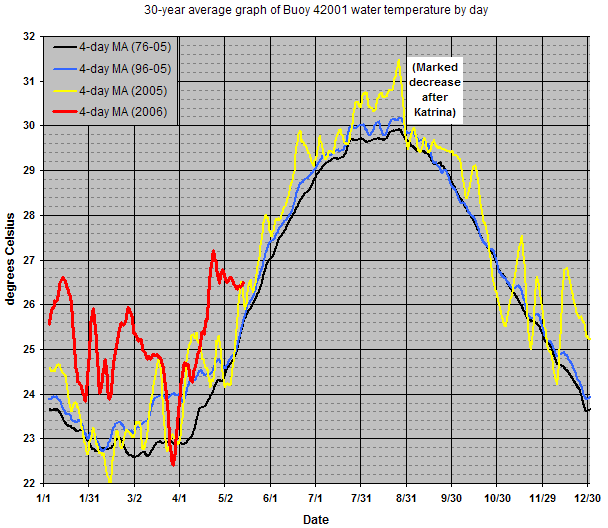
mtm4319 wrote:One thing I've been looking at the past couple of weeks is Buoy 26001 in the Gulf of Mexico. Temperatures there have been running as much as 5-6 degrees F above normal. 19% of the every-6-hour observations this year have been 30-year highs, compared to the average of (obviously) 3.3%.

The temperature at this buoy was 31.5 degrees Celsius the day before Katrina passed through; 2006 so far has averaged 1.4 degrees C (2.5 degrees F) above 2005 temperatures.

Image Image


how did you find that buoy with google earth
0 likes   

mtm4319
Category 5
Category 5
Posts: 1537
Joined: Sun Sep 12, 2004 2:47 am
Location: Mobile, AL

#12 Postby mtm4319 » Sun Apr 30, 2006 4:00 pm

fact789 wrote:how did you find that buoy with google earth


I just made a placemark and inserted the latitude/longitude coordinates found here.
0 likes   

JonathanBelles
Professional-Met
Professional-Met
Posts: 11430
Age: 35
Joined: Sat Dec 24, 2005 9:00 pm
Location: School: Florida State University (Tallahassee, FL) Home: St. Petersburg, Florida
Contact:

#13 Postby JonathanBelles » Sun Apr 30, 2006 4:01 pm

ok thanks
0 likes   

CHRISTY

#14 Postby CHRISTY » Sun Apr 30, 2006 7:06 pm

These MAPS have now been updated...

Image

Image

Image

These maps are from a different sourse...I Tend to like these better!
(Atlantic Sea Surface Temps In 120 hrs.)
Image

Gulf of Mexico Temps in 120 hrs.

Image

Southeast temps 120 hrs.

Image

Maximum Potential Hurricane Intensity....

Image
0 likes   

JonathanBelles
Professional-Met
Professional-Met
Posts: 11430
Age: 35
Joined: Sat Dec 24, 2005 9:00 pm
Location: School: Florida State University (Tallahassee, FL) Home: St. Petersburg, Florida
Contact:

#15 Postby JonathanBelles » Sun Apr 30, 2006 7:08 pm

on image 6 why is there a cool pocket on top of the yucatan or west of the loop current
0 likes   

User avatar
JamesFromMaine2
Category 4
Category 4
Posts: 989
Joined: Tue Jul 19, 2005 1:38 am
Location: Portland Maine USA
Contact:

#16 Postby JamesFromMaine2 » Sun Apr 30, 2006 7:12 pm

theres already areas in the Gulf that can support a cat 5!
0 likes   

User avatar
Ivan14
Tropical Storm
Tropical Storm
Posts: 184
Joined: Thu Mar 16, 2006 10:49 am
Contact:

#17 Postby Ivan14 » Mon May 01, 2006 2:19 am

Wow that is amazing that the Gulf Of Mexico can support a category 5.
0 likes   

HurricaneHunter914
Category 5
Category 5
Posts: 4439
Age: 31
Joined: Fri Mar 10, 2006 7:36 pm
Location: College Station, TX

#18 Postby HurricaneHunter914 » Mon May 01, 2006 3:27 am

But the shear doesn't support Cat-5s at all.
0 likes   

User avatar
milankovitch
Tropical Storm
Tropical Storm
Posts: 243
Age: 40
Joined: Fri Sep 17, 2004 11:30 pm
Location: Menands, NY; SUNY Albany
Contact:

#19 Postby milankovitch » Mon May 01, 2006 12:44 pm

Jaw, floor, I assume you've met. :eek:
Image
0 likes   

User avatar
SouthFloridawx
S2K Supporter
S2K Supporter
Posts: 8346
Age: 46
Joined: Tue Jul 26, 2005 1:16 am
Location: Sarasota, FL
Contact:

#20 Postby SouthFloridawx » Mon May 01, 2006 1:02 pm

That image answers a few questions I had about some graphics that some members posted earlier.
0 likes   


Return to “Talkin' Tropics”

Who is online

Users browsing this forum: duilaslol, Sps123 and 44 guests