Atlantic LSU Image
It's a good convective complex area that has emerged Western Africa.But as it happens many,many times as soon they move a couple hundred miles from the coast they start to fizzle.But thinking about this,maybe this may be the system the GFS has been moving thru the Caribbean by next week but without any development and the San Juan AFD eluded to last weekend.
Enjoy it while it lasts (In East Atlantic)
Moderator: S2k Moderators
Forum rules

The posts in this forum are NOT official forecasts and should not be used as such. They are just the opinion of the poster and may or may not be backed by sound meteorological data. They are NOT endorsed by any professional institution or STORM2K. For official information, please refer to products from the National Hurricane Center and National Weather Service.
-
cycloneye

- Admin

- Posts: 148763
- Age: 69
- Joined: Thu Oct 10, 2002 10:54 am
- Location: San Juan, Puerto Rico
Enjoy it while it lasts (In East Atlantic)
Last edited by cycloneye on Wed Jun 07, 2006 10:32 pm, edited 1 time in total.
0 likes
-
Hybridstorm_November2001

- S2K Supporter

- Posts: 2817
- Joined: Sat Aug 21, 2004 2:50 pm
- Location: SW New Brunswick, Canada
- Contact:

-
senorpepr

- Military Met/Moderator

- Posts: 12542
- Age: 43
- Joined: Fri Aug 22, 2003 9:22 pm
- Location: Mackenbach, Germany
- Contact:
Well, although it has some pretty nice low-level confluence and upper-level difluence now, it will see some of the dry air to it's north get entrained into the wave in the near future. Thereafter, the steering flow takes it west-southwesterly, so the lack of coriolis won't help for cyclogenesis. However, if it does make it further north of 10°N, then it will run into some increased shear (60-90 kt) associated with the subtropical jet.
My vote... no.
My vote... no.
0 likes
-
MiamiensisWx

-
cycloneye
- Admin
- Posts: 148763
- Age: 69
- Joined: Thu Oct 10, 2002 10:54 am
- Location: San Juan, Puerto Rico
That is why the title says (Enjoy it while it lasts). 
0 likes
Visit the Caribbean-Central America Weather Thread where you can find at first post web cams,radars
and observations from Caribbean basin members Click Here
and observations from Caribbean basin members Click Here
-
beachbum_al

- Category 5

- Posts: 2163
- Age: 55
- Joined: Thu Jul 14, 2005 9:23 pm
- Location: South Alabama Coast
- Contact:
-
CHRISTY
-
MiamiensisWx
-
MiamiensisWx
-
hurricanetrack

- HurricaneTrack.com
- Posts: 1781
- Joined: Tue Dec 02, 2003 10:46 pm
- Location: Wilmington, NC
- Contact:
It will be awesome to see the Cape Verde hurricane make a return this season. If they only had minimal impact on people- then we could all stand up and cheer for them. As it stands, they roll people up and destroy property- but they are spectacular to see on satellite photos. Not too long to go....
0 likes
-
cycloneye
- Admin
- Posts: 148763
- Age: 69
- Joined: Thu Oct 10, 2002 10:54 am
- Location: San Juan, Puerto Rico
CLUSTERS
OF MODERATE TO STRONG CONVECTION IS WITHIN 180 NM EITHER SIDE OF
THE AXIS E OF 27W. A TROPICAL WAVE MAY BE LOCATED NEAR 20W
ENHANCING THIS ACTIVITY.
All of us haved joked with this and right to do so but I admit that this wave at least has hanged good a little bit longer than other ones so far this year.
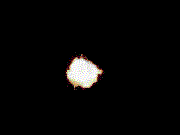
Atlantic LSU Image
I forgot to mention at the first post that this LSU image is of three hours intervals.
OF MODERATE TO STRONG CONVECTION IS WITHIN 180 NM EITHER SIDE OF
THE AXIS E OF 27W. A TROPICAL WAVE MAY BE LOCATED NEAR 20W
ENHANCING THIS ACTIVITY.
All of us haved joked with this and right to do so but I admit that this wave at least has hanged good a little bit longer than other ones so far this year.
Atlantic LSU Image
I forgot to mention at the first post that this LSU image is of three hours intervals.
0 likes
-
cycloneye
- Admin
- Posts: 148763
- Age: 69
- Joined: Thu Oct 10, 2002 10:54 am
- Location: San Juan, Puerto Rico
Infared Image
For those who like to see the colorized image here it is.This one is of 6 hour intervals.
For those who like to see the colorized image here it is.This one is of 6 hour intervals.
0 likes

Who is online
Users browsing this forum: No registered users and 37 guests