The posts in this forum are NOT official forecast and should not be used as such. They are just the opinion of the poster and may or may not be backed by sound meteorological data. They are NOT endorsed by any professional institution or


Joshua21Young wrote:What are the implications of this big Kelvin (sp?) wave on the weather for the southwestern US this year? :-?If it's too early to tell I understand.
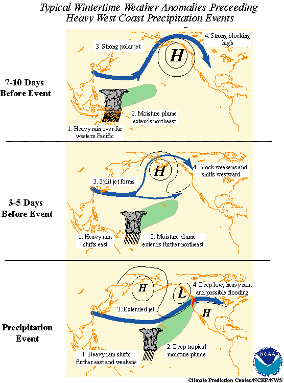
it depends on where the areas of enhanced and spressed convection are located which relate best to where the heaviest precipitation is likely to occur along the west coast.
though that said the strongest correlation between the MJO and heavy precipitation is across the pacific northeast (which ties the ENSO phase into MJO activity...where El Nino events see LESS in the way of MJO activity corresponding to less precipitation across the pacific northwest during those periods...and enhanced precipitation in la nina winters where the PAC jet is more variable and MJO activity more prevalent).
Normally prior to significant precipitation events...the heaviest convection related to the MJO is located back across indonesia (~120E) and supressed convection over the indian ocean and the central pacific.
this is shown well by areas of above and below normal anomalous OLR (outgoing Longwave radiation) shown in the figure below:

notice the area of above normal OLR anomalies across the indian ocean indicative of supressed convection with below normal OLR anomalies further east corresponsing to increrased convection. this set-up observed currently is most favorable for a heavy precipitation event in the PAC northwest as compared to areas further south. though even now as the waves of increased and decreased convection shift around...we are losing that correlation as well.
the area of increased convection would have to be located between roughly 160E and 170E for the correspondence between the MJO and a major precipitation event across the southwest US to be the strongest. even what that said as i talked about previously the connection between MJO activity and heavy precipitation events is LESS the further south along the west coast one goes.
Just recently a STRONG kelvin wave has moved eastward out of indonesia and is heading east across the equatorial pacific which is associated with enhanced convection...shown in the figure below:

Notice the location of the wave is near 180 (the dateline) which as it continues east would be more favorable for heavy precipitation across the southwest. Even given the decreased connection.
suffice to say that the further east the area of convection associated with the MJO is located the better the potential for heavy precipitation events across the southwest USA is.