ATL : INVEST 94L
Moderator: S2k Moderators
-
Ivanhater

- Storm2k Moderator

- Posts: 11216
- Age: 39
- Joined: Fri Jul 01, 2005 8:25 am
- Location: Pensacola
Re: ATL : INVEST 94L
After looking at the run. the reason for this track, the second front is not as strong and misses it, then she moves around the edge of the high as it moves east
0 likes
Michael
-
Brent
- S2K Supporter

- Posts: 38624
- Age: 37
- Joined: Sun May 16, 2004 10:30 pm
- Location: Tulsa Oklahoma
- Contact:
Re:
gatorcane wrote:18Z GFS goes crazy with this thing now, major cane in the GOM (albeit way out at 324 hours).
Ivanhater, check it out:

Major hurricane in the Gulf on November 4th... I think I'll go play the lottery now. Better chance of winning than that happening.
0 likes
#neversummer
-
Derek Ortt
-
cycloneye

- Admin

- Posts: 148833
- Age: 69
- Joined: Thu Oct 10, 2002 10:54 am
- Location: San Juan, Puerto Rico
Re: ATL : INVEST 94L
I would not get excited with a run especially with a 18z run because those dont have all the data that the 12z and 00z runs have.Now,if the 00z run later tonight shows similar scenario,then more attention has to be payed.
0 likes
Visit the Caribbean-Central America Weather Thread where you can find at first post web cams,radars
and observations from Caribbean basin members Click Here
and observations from Caribbean basin members Click Here
-
AtlanticWind

- S2K Supporter
- Posts: 1898
- Age: 67
- Joined: Sun Aug 08, 2004 9:57 pm
- Location: Plantation,Fla
Re:
Derek Ortt wrote:it weakens significantly before landfall
it COULD happen... Kate was a cat 3 in the GOM. It also behaved like nearly every other strong GOM hurricane and rapidly weakened just prior to landfall
It could happen but the GFS at 2 weeks out , I would stick with climo at this point.
0 likes


-
StarmanHDB

- Tropical Storm

- Posts: 202
- Age: 61
- Joined: Wed Sep 02, 2009 7:59 pm
- Location: West Palm Beach, Florida
Interesting how on Sunday, a close friend who posts on this board called to tell me to "keep my eye on the Western Caribbean". Out of respect to him, I'm not going to mention his name, but in regards to tropical weather, this guy never posts or makes any comments to anyone unless he's completely sure. Pretty amazing!
How do you guys do this?
How do you guys do this?
0 likes
-
cycloneye
- Admin
- Posts: 148833
- Age: 69
- Joined: Thu Oct 10, 2002 10:54 am
- Location: San Juan, Puerto Rico
Re: ATL : INVEST 94L
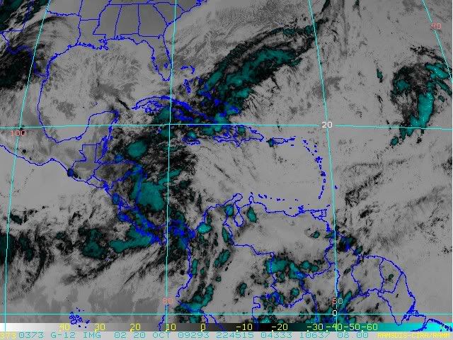
TROPICAL WEATHER OUTLOOK
NWS TPC/NATIONAL HURRICANE CENTER MIAMI FL
800 PM EDT TUE OCT 20 2009
FOR THE NORTH ATLANTIC...CARIBBEAN SEA AND THE GULF OF MEXICO...
A BROAD AREA OF LOW PRESSURE OVER THE SOUTHWESTERN CARIBBEAN SEA
IS PRODUCING A LARGE AREA OF CLOUDINESS AND SHOWERS. ANY
DEVELOPMENT OF THIS SYSTEM IS EXPECTED TO BE SLOW TO OCCUR AS
IT REMAINS NEARLY STATIONARY DURING THE NEXT COUPLE OF DAYS.
REGARDLESS OF DEVELOPMENT...HEAVY RAINS ARE POSSIBLE OVER
PORTIONS OF CENTRAL AMERICA. THERE IS A LOW CHANCE...LESS THAN
30 PERCENT...OF THIS SYSTEM BECOMING A TROPICAL CYCLONE DURING THE
NEXT 48 HOURS.
ELSEWHERE...TROPICAL CYCLONE FORMATION IS NOT EXPECTED DURING THE
NEXT 48 HOURS.
$$
FORECASTER BROWN
0 likes
Visit the Caribbean-Central America Weather Thread where you can find at first post web cams,radars
and observations from Caribbean basin members Click Here
and observations from Caribbean basin members Click Here
Re: ATL : INVEST 94L - Models
That 18Z GFS run is strange - pretty strong trough and cold front blowing through the northern gulf on October 28th yet the low pressure doesn't get picked up - hard to believe.
0 likes
-
gatorcane

- S2K Supporter
- Posts: 23704
- Age: 47
- Joined: Sun Mar 13, 2005 3:54 pm
- Location: Boca Raton, FL
Re:
Derek Ortt wrote:it weakens significantly before landfall
it COULD happen... Kate was a cat 3 in the GOM. It also behaved like nearly every other strong GOM hurricane and rapidly weakened just prior to landfall
Yeah not to mention SSTs across much of the GOM have cooled since that powerful front.
They couldn't support a major cane at this point in my opinion.
GFS is on crack. The 12Z ECMWF is more realistic -- a weak system pulling NE ahead of a trough.....
0 likes
-
cycloneye
- Admin
- Posts: 148833
- Age: 69
- Joined: Thu Oct 10, 2002 10:54 am
- Location: San Juan, Puerto Rico
Re: ATL : INVEST 94L - Models
ronjon wrote:That 18Z GFS run is strange - pretty strong trough and cold front blowing through the northern gulf on October 28th yet the low pressure doesn't get picked up - hard to believe.
I would wait for the 00z suite to see if it shows the same.Remember that the 00z and 12z runs have more data than the 06z and 18z runs.
0 likes
Visit the Caribbean-Central America Weather Thread where you can find at first post web cams,radars
and observations from Caribbean basin members Click Here
and observations from Caribbean basin members Click Here
-
Ivanhater
- Storm2k Moderator
- Posts: 11216
- Age: 39
- Joined: Fri Jul 01, 2005 8:25 am
- Location: Pensacola
Re: ATL : INVEST 94L
To be fair, this far out. Whatever the models are showing now (including tonight's run) are going to change. Storms have hit the Panhandle, even in November. Depends on the set-up. However, I would stick with climo right now, given that we are still looking at the long range and models are flip flopping. Either way, the 2009 season may not go gently into that goodnight
0 likes
Michael
-
wxman57

- Moderator-Pro Met

- Posts: 23165
- Age: 68
- Joined: Sat Jun 21, 2003 8:06 pm
- Location: Houston, TX (southwest)
Re: ATL : INVEST 94L - Models
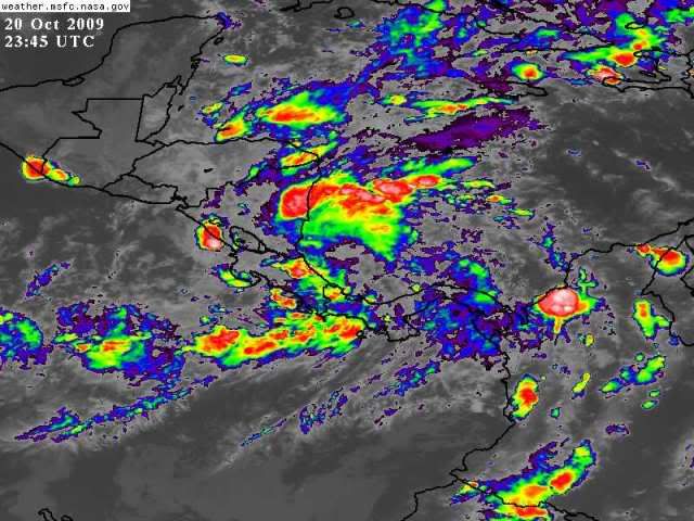
No models run on 94 since 12Z. Doesn't really appear to qualify for an invest at this time. It's days away from any real chance of development, and the vorticity center appears to be inland over coastal Nicaragua tonight. I'm starting to feel a bit better about this system, meaning a decreasing chance of development.
0 likes
-
Ivanhater
- Storm2k Moderator
- Posts: 11216
- Age: 39
- Joined: Fri Jul 01, 2005 8:25 am
- Location: Pensacola
Re: ATL : INVEST 94L - Models
wxman57 wrote:No models run on 94 since 12Z. Doesn't really appear to qualify for an invest at this time. It's days away from any real chance of development, and the vorticity center appears to be inland over coastal Nicaragua tonight. I'm starting to feel a bit better about this system, meaning a decreasing chance of development.
Just taking a look at the models, it seems the genesis of this system will take place just west of Jamaica, not Central America. I would have the opposite feeling, now that the GFS has latched onto development. Still plenty of time to see though.
0 likes
Michael

Question about West Central Florida
Is the possible scenario the european model is showing the scenario that could threaten West Central Florida?
0 likes
-
Dean4Storms
- S2K Supporter
- Posts: 6358
- Age: 62
- Joined: Sun Aug 31, 2003 1:01 pm
- Location: Miramar Bch. FL
Who is online
Users browsing this forum: No registered users and 63 guests