ATL : TROPICAL DEPRESSION IDA

Moderator: S2k Moderators

Message
Author
User avatar
ROCK
Category 5
Category 5
Posts: 9483
Age: 54
Joined: Tue Aug 17, 2004 7:30 am
Location: Kemah, Texas

Re:

#101 Postby ROCK » Tue Nov 03, 2009 10:53 pm

wyq614 wrote:Cuba's model leans towards Belize solution, but moves it rather fast, being a system around 1000hpa just to the north of Honduras in 3 days....


http://www.insmet.cu/asp/genesis.asp?TB ... s/presion/


Hey thanks...never knew Cuba had a model until now. :lol:
0 likes   

ozonepete
Professional-Met
Professional-Met
Posts: 4743
Joined: Mon Sep 07, 2009 3:23 pm
Location: From Ozone Park, NYC / Now in Brooklyn, NY

Re:

#102 Postby ozonepete » Tue Nov 03, 2009 11:14 pm

gatorcane wrote:it's important to watch what's going on across Panama in the EPAC about 500 miles west of 97L. Some models continue to develop this area instead. If that EPAC system gets going, shear would increase across the Western Caribbean. The 00Z GFS rolling in is not quite as bullish through the first 60 hours and generally moves the area NW into Central America. Should that happen, the EPAC area could be the focus of where development may happen.

Anyway, the UKMET/GFDL/HWRF are developing 97L more quickly and I believe they are seeing a large weakness in the ridge way off to the north passing by the NE CONUS and digging down into the Western Atlantic, eroding the Bermuda High ridge....that would give 97L just enough of a few days tug N or NNE, if it were deep enough (then some H5 ridging could develop again across the Eastern CONUS/GOM, which would block northward progress of 97L down the road).

Image


That's a really great analysis of what the models see, and what might come of this, gatorcane. What we need to see now is how strong each of these disturbances get. After all, the models won't know any better until they ingest the next states of these two systems. From watching the current cloud motions, I think 97L has a little bit of an advantage. The disturbance in the EPAC is moving north or northeast a little too quickly and seems like it will end up over land or too close to it while 97L is still over water.
0 likes   

Sanibel
Category 5
Category 5
Posts: 10375
Joined: Mon Aug 30, 2004 11:06 pm
Location: Offshore SW Florida

Re: ATL : INVEST 97L

#103 Postby Sanibel » Wed Nov 04, 2009 12:02 am

IMO it needs to pull north or it will either dissipate or pull into Nicaragua.
0 likes   

jconsor
Professional-Met
Professional-Met
Posts: 547
Joined: Mon Jun 30, 2008 9:31 pm
Location: Jerusalem, Israel
Contact:

Re: ATL : INVEST 97L

#104 Postby jconsor » Wed Nov 04, 2009 2:43 am

The closest surface obs are about 175 miles away from the center - Tocumen, Panama and Puerto Limon, Costa Rica (which doesn't report overnight). Since this is a compact system, the fact that these surface obs are reporting 10-15 mph winds doesn't mean much. There likely are stronger winds closer to the center, but we won't know for sure until recon arrives.

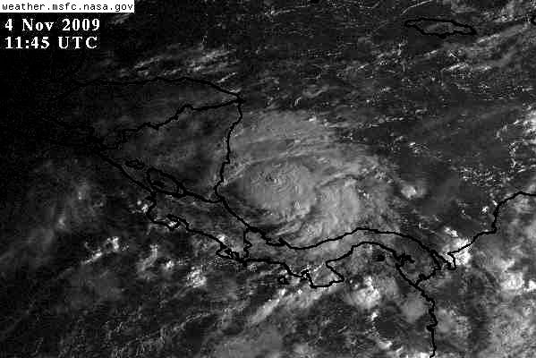
In any case the satellite presentation continues to improve.

wxman57 wrote:Convection is still pulsing here and there, but not in one spot. Doesn't look too much different from the past 24 hours. Actual surface obs in the area still don't show much wind. Though they're not too numerous, they don't seem to confirm winds nearly as high as QS estimates, but the two aren't matching up exactly over the same areas. Maybe if we could get one single QS that actually covers the whole system we could compare surface obs place for place with QS. Figures that QS has missed this area for the past 4 passes. It's the only tropical strip missed.
0 likes   

User avatar
Ivanhater
Storm2k Moderator
Storm2k Moderator
Posts: 11153
Age: 38
Joined: Fri Jul 01, 2005 8:25 am
Location: Pensacola

Re: ATL : INVEST 97L

#105 Postby Ivanhater » Wed Nov 04, 2009 3:33 am

ROCK wrote:Nice LLC growing stronger and banding features... I am also on the "go" band wagon.

Nice to see you Ivan...been a slow year... :D


Lol Rock, after these past few years on the gulf coast, this year has been a welcome break! I will always have a suspicious eye on the tropics...well see...
0 likes   
Michael

User avatar
Evil Jeremy
S2K Supporter
S2K Supporter
Posts: 5463
Age: 31
Joined: Mon Apr 10, 2006 2:10 pm
Location: Los Angeles, CA

Re: ATL : INVEST 97L

#106 Postby Evil Jeremy » Wed Nov 04, 2009 6:51 am

I am calling for a code red at the next TWO. Look at the convection pulsing on this!

http://www.ssd.noaa.gov/goes/flt/t2/wv-l.jpg
0 likes   
Frances 04 / Jeanne 04 / Katrina 05 / Wilma 05 / Fay 08 / Debby 12 / Andrea 13 / Colin 16 / Hermine 16 / Matthew 16 / Irma 17

User avatar
HURAKAN
Professional-Met
Professional-Met
Posts: 46086
Age: 38
Joined: Thu May 20, 2004 4:34 pm
Location: Key West, FL
Contact:

#107 Postby HURAKAN » Wed Nov 04, 2009 6:55 am

Image

Looking great
0 likes   

User avatar
cycloneye
Admin
Admin
Posts: 143863
Age: 68
Joined: Thu Oct 10, 2002 10:54 am
Location: San Juan, Puerto Rico

Re: ATL : INVEST 97L

#108 Postby cycloneye » Wed Nov 04, 2009 6:55 am

Code Red


KNHC 041154
TWOAT
TROPICAL WEATHER OUTLOOK
NWS TPC/NATIONAL HURRICANE CENTER MIAMI FL
700 AM EST WED NOV 4 2009

FOR THE NORTH ATLANTIC...CARIBBEAN SEA AND THE GULF OF MEXICO...

SHOWERS AND THUNDERSTORMS ASSOCIATED WITH AN AREA OF LOW PRESSURE IN
THE EXTREME SOUTHWESTERN CARIBBEAN SEA HAVE INCREASED THIS MORNING
AND A TROPICAL DEPRESSION COULD FORM AT ANY TIME TODAY. UPPER-
LEVEL WINDS ARE FAVORABLE FOR ADDITIONAL DEVELOPMENT AS THE LOW
REMAINS NEARLY STATIONARY DURING THE NEXT DAY OR SO. AN AIR FORCE
RESERVE RECONNAISSANCE PLANE IS SCHEDULED TO INVESTIGATE THIS
SYSTEM THIS AFTERNOON. THERE IS A HIGH CHANCE...GREATER THAN 50
PERCENT...OF THIS SYSTEM BECOMING A TROPICAL CYCLONE DURING THE
NEXT 48 HOURS. LOCALLY HEAVY RAINS ARE POSSIBLE OVER THE NEXT FEW
DAYS OVER PORTIONS OF PANAMA...COSTA RICA...NICARAGUA...AND
HONDURAS IN ASSOCIATION WITH THIS SYSTEM.

ELSEWHERE...TROPICAL CYCLONE FORMATION IS NOT EXPECTED DURING THE
NEXT 48 HOURS.

$$
FORECASTER KIMBERLAIN/BLAKE

Image
0 likes   
Visit the Caribbean-Central America Weather Thread where you can find at first post web cams,radars
and observations from Caribbean basin members Click Here

User avatar
HURAKAN
Professional-Met
Professional-Met
Posts: 46086
Age: 38
Joined: Thu May 20, 2004 4:34 pm
Location: Key West, FL
Contact:

#109 Postby HURAKAN » Wed Nov 04, 2009 7:06 am

Image

First visible
0 likes   

User avatar
HURAKAN
Professional-Met
Professional-Met
Posts: 46086
Age: 38
Joined: Thu May 20, 2004 4:34 pm
Location: Key West, FL
Contact:

#110 Postby HURAKAN » Wed Nov 04, 2009 7:23 am

Image

Very nice system.
0 likes   

User avatar
HURAKAN
Professional-Met
Professional-Met
Posts: 46086
Age: 38
Joined: Thu May 20, 2004 4:34 pm
Location: Key West, FL
Contact:

#111 Postby HURAKAN » Wed Nov 04, 2009 7:26 am

04/1145 UTC 10.9N 81.6W T2.0/2.0 97L

Maybe an upgrade is in order before RECON
0 likes   

User avatar
DESTRUCTION5
Category 5
Category 5
Posts: 4423
Age: 43
Joined: Wed Sep 03, 2003 11:25 am
Location: Stuart, FL

#112 Postby DESTRUCTION5 » Wed Nov 04, 2009 7:29 am

"IDA" gotta think we have a upgrade at 11. :D
0 likes   
GATOR NATION IS E V E R Y W H E R E !

User avatar
cycloneye
Admin
Admin
Posts: 143863
Age: 68
Joined: Thu Oct 10, 2002 10:54 am
Location: San Juan, Puerto Rico

Re: ATL : INVEST 97L=7 AM EST TWO=Code Red,Recon is a go

#113 Postby cycloneye » Wed Nov 04, 2009 7:37 am

The question is if new EPAC invest 96E will affect in some way 97L?
0 likes   
Visit the Caribbean-Central America Weather Thread where you can find at first post web cams,radars
and observations from Caribbean basin members Click Here

User avatar
HURAKAN
Professional-Met
Professional-Met
Posts: 46086
Age: 38
Joined: Thu May 20, 2004 4:34 pm
Location: Key West, FL
Contact:

#114 Postby HURAKAN » Wed Nov 04, 2009 7:40 am

Image

At the moment, 97L has the upper hand.
0 likes   

User avatar
Macrocane
Category 5
Category 5
Posts: 4218
Age: 36
Joined: Sun May 24, 2009 5:35 pm
Location: El Salvador

Re: ATL : INVEST 97L=7 AM EST TWO=Code Red,Recon is a go

#115 Postby Macrocane » Wed Nov 04, 2009 7:42 am

Nice LLC circulation, strong convecion near the center, banding features, what more is needed to call this a TD? I think that the first advisory will be issued in a few hours. It will be an interesting week if it intensifies into Ida and even more interesting if invest 96-E develops too as they both can have influence on the weather here.
0 likes   

User avatar
gatorcane
S2K Supporter
S2K Supporter
Posts: 23689
Age: 47
Joined: Sun Mar 13, 2005 3:54 pm
Location: Boca Raton, FL

#116 Postby gatorcane » Wed Nov 04, 2009 7:43 am

OK so I jumped the gun a bit yesterday by saying it would be code RED yesterday, anyway it is code RED and development chances are high indeed.
0 likes   

User avatar
boca
Category 5
Category 5
Posts: 6365
Age: 60
Joined: Mon Dec 15, 2003 8:49 am
Location: Boca Raton,FL

Re: ATL : INVEST 97L=7 AM EST TWO=Code Red,Recon is a go

#117 Postby boca » Wed Nov 04, 2009 7:51 am

97L will only stenghthen if it doesn't move inland.I don't see this moving north due to the strong high building over the eastern US.
0 likes   

User avatar
cycloneye
Admin
Admin
Posts: 143863
Age: 68
Joined: Thu Oct 10, 2002 10:54 am
Location: San Juan, Puerto Rico

Re: ATL : INVEST 97L

#118 Postby cycloneye » Wed Nov 04, 2009 8:02 am

IMO,they will wait for recon that will go this afternoon to see what they find.
0 likes   
Visit the Caribbean-Central America Weather Thread where you can find at first post web cams,radars
and observations from Caribbean basin members Click Here

User avatar
HURAKAN
Professional-Met
Professional-Met
Posts: 46086
Age: 38
Joined: Thu May 20, 2004 4:34 pm
Location: Key West, FL
Contact:

#119 Postby HURAKAN » Wed Nov 04, 2009 8:08 am

Image

Quite impressive
0 likes   

User avatar
KWT
Category 5
Category 5
Posts: 31415
Joined: Tue Aug 17, 2004 11:02 am
Location: UK!!!

#120 Postby KWT » Wed Nov 04, 2009 8:08 am

This is the sort of system that recon will likely find a low end TS by the time they get there, probably wth a small radius of top winds as well.
0 likes   
Personal Forecast Disclaimer:
The posts in this forum are NOT official forecast and should not be used as such. They are just the opinion of the poster and may or may not be backed by sound meteorological data. They are NOT endorsed by any professional institution or storm2k.org. For official information, please refer to the NHC and NWS products


Return to “2009”

Who is online

Users browsing this forum: No registered users and 17 guests