2013 Steering Pattern / Early indicators
Moderator: S2k Moderators
Forum rules

The posts in this forum are NOT official forecasts and should not be used as such. They are just the opinion of the poster and may or may not be backed by sound meteorological data. They are NOT endorsed by any professional institution or STORM2K. For official information, please refer to products from the National Hurricane Center and National Weather Service.
-
cycloneye

- Admin

- Posts: 149471
- Age: 69
- Joined: Thu Oct 10, 2002 10:54 am
- Location: San Juan, Puerto Rico
Re: 2013 Steering Pattern / Early indicators
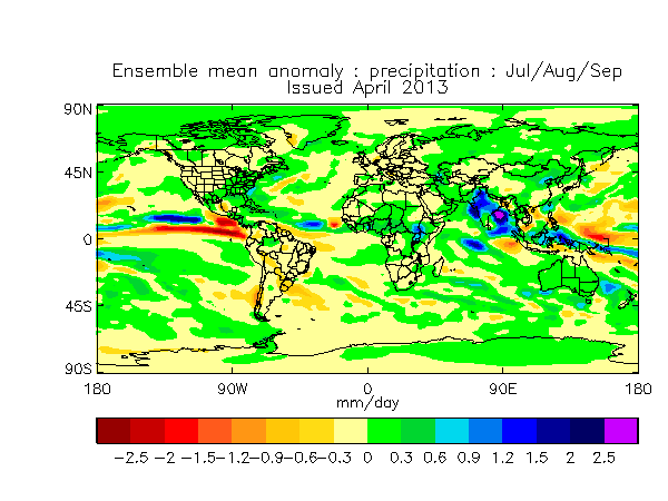
This is the UKMET forecast of precipitation for July/August and September. Look how enhanced is the moisture in the MDR area.
0 likes
Visit the Caribbean-Central America Weather Thread where you can find at first post web cams,radars
and observations from Caribbean basin members Click Here
and observations from Caribbean basin members Click Here
-
wxman57

- Moderator-Pro Met

- Posts: 23174
- Age: 68
- Joined: Sat Jun 21, 2003 8:06 pm
- Location: Houston, TX (southwest)
Re: 2013 Steering Pattern / Early indicators
Yes. Main development region shifts southward from the subtropics in 2012 to the deep tropics in 2013. That greatly increases the chances of you being hit, Luis. And it also increases the risk to the Gulf and SE U.S. coast. I plan to be quite busy in August & September. Hopefully, the season gets off to a very slow start like 2004.
0 likes
-
CYCLONE MIKE
- Category 5

- Posts: 2183
- Joined: Tue Aug 31, 2004 6:04 pm
- Location: Gonzales, LA
Re: 2013 Steering Pattern / Early indicators
wxman,
You think the conditions in the gulf will be more favorable towards a true major hurricane this year. Although we have been hit here in south LA a few times they could have been much much worse if not for all the dry air, lack of instability, and of course shear.
You think the conditions in the gulf will be more favorable towards a true major hurricane this year. Although we have been hit here in south LA a few times they could have been much much worse if not for all the dry air, lack of instability, and of course shear.
0 likes
-
wxman57
- Moderator-Pro Met
- Posts: 23174
- Age: 68
- Joined: Sat Jun 21, 2003 8:06 pm
- Location: Houston, TX (southwest)
Re: 2013 Steering Pattern / Early indicators
CYCLONE MIKE wrote:wxman,
You think the conditions in the gulf will be more favorable towards a true major hurricane this year. Although we have been hit here in south LA a few times they could have been much much worse if not for all the dry air, lack of instability, and of course shear.
I don't think the conditions in the Gulf were extremely unfavorable in 2012. If Isaac hadn't tracked over so much land, it may have become a Cat 3 or 4 in the Gulf. But with a much less hostile Caribbean this season, there's a greater risk of an intense hurricane in the Gulf.
0 likes

Re: 2013 Steering Pattern / Early indicators
wxman57 wrote:CYCLONE MIKE wrote:wxman,
You think the conditions in the gulf will be more favorable towards a true major hurricane this year. Although we have been hit here in south LA a few times they could have been much much worse if not for all the dry air, lack of instability, and of course shear.
I don't think the conditions in the Gulf were extremely unfavorable in 2012. If Isaac hadn't tracked over so much land, it may have become a Cat 3 or 4 in the Gulf. But with a much less hostile Caribbean this season, there's a greater risk of an intense hurricane in the Gulf.
Wonderful...
0 likes
-
vbhoutex

- Storm2k Executive
- Posts: 29149
- Age: 74
- Joined: Wed Oct 09, 2002 11:31 pm
- Location: Cypress, TX
- Contact:
Re: 2013 Steering Pattern / Early indicators
ROCK wrote:wxman57 wrote:CYCLONE MIKE wrote:wxman,
You think the conditions in the gulf will be more favorable towards a true major hurricane this year. Although we have been hit here in south LA a few times they could have been much much worse if not for all the dry air, lack of instability, and of course shear.
I don't think the conditions in the Gulf were extremely unfavorable in 2012. If Isaac hadn't tracked over so much land, it may have become a Cat 3 or 4 in the Gulf. But with a much less hostile Caribbean this season, there's a greater risk of an intense hurricane in the Gulf.
Wonderful...
Good to see you Rock!! My thoughts exactly. Maybe we need to request the cockroach ridge of death again?
0 likes
Skywarn, C.E.R.T.
Please click below to donate to STORM2K to help with the expenses of keeping the site going:

Please click below to donate to STORM2K to help with the expenses of keeping the site going:
-
Hurricane Andrew

- S2K Supporter

- Posts: 1891
- Age: 27
- Joined: Sun May 23, 2010 2:53 pm
- Location: KS
-
vbhoutex
- Storm2k Executive
- Posts: 29149
- Age: 74
- Joined: Wed Oct 09, 2002 11:31 pm
- Location: Cypress, TX
- Contact:
Re:
Hurricane Andrew wrote:What's that? Ridge of Death is the one that keeps everything in the gulf suppressed, right?
Basically a ridge of high pressure that sets up along the N GOM coastal area and makes us very hot and dry. It doesn't necessarily suppress everything in the Gulf but it "protects" the coast as long as it stays along the coast or in the N GOM. Generally when it is in existence the TC that do make it into the GOM usually make a landfall somewhere in Mexico or deep S TX near Brownsville.
0 likes
Skywarn, C.E.R.T.
Please click below to donate to STORM2K to help with the expenses of keeping the site going:
Please click below to donate to STORM2K to help with the expenses of keeping the site going:
-
cycloneye
- Admin
- Posts: 149471
- Age: 69
- Joined: Thu Oct 10, 2002 10:54 am
- Location: San Juan, Puerto Rico
Re: 2013 Steering Pattern / Early indicators
There is a change in the operational ECMWF about the MSLP data in the April update that shows higher pressures than in the March update. But the ensemble mean data shows only a modest reflection of those higher pressures.wxman57, what is your take on this April update?
March ECMWF Operational update for July, August, September

March ECMWF Ensemble Mean update for July, August, September

April ECMWF Operational Update for August, September, October

April ECMWF Ensemble Mean Update for August, September, October

March ECMWF Operational update for July, August, September
March ECMWF Ensemble Mean update for July, August, September
April ECMWF Operational Update for August, September, October
April ECMWF Ensemble Mean Update for August, September, October
0 likes
Visit the Caribbean-Central America Weather Thread where you can find at first post web cams,radars
and observations from Caribbean basin members Click Here
and observations from Caribbean basin members Click Here
-
SFLcane

- S2K Supporter
- Posts: 10281
- Age: 48
- Joined: Sat Jun 05, 2010 1:44 pm
- Location: Lake Worth Florida
Re: 2013 Steering Pattern / Early indicators
Luis can you post a link to the mslp data.
Erased from pc
Erased from pc
0 likes
-
cycloneye
- Admin
- Posts: 149471
- Age: 69
- Joined: Thu Oct 10, 2002 10:54 am
- Location: San Juan, Puerto Rico
Re: 2013 Steering Pattern / Early indicators
SFLcane wrote:Luis can you post a link to the mslp data.
Erased from pc
There you go!
http://www.ecmwf.int/products/forecasts ... 0summary!/
0 likes
Visit the Caribbean-Central America Weather Thread where you can find at first post web cams,radars
and observations from Caribbean basin members Click Here
and observations from Caribbean basin members Click Here
-
SFLcane
- S2K Supporter
- Posts: 10281
- Age: 48
- Joined: Sat Jun 05, 2010 1:44 pm
- Location: Lake Worth Florida
Re: 2013 Steering Pattern / Early indicators
cycloneye wrote:SFLcane wrote:Luis can you post a link to the mslp data.
Erased from pc
There you go!
http://www.ecmwf.int/products/forecasts ... 0summary!/
Wow hopefully not more sub-tropic garbage
Time will tell
0 likes
-
TropicalAnalystwx13

- Category 5
- Posts: 2109
- Age: 28
- Joined: Tue Jul 19, 2011 8:20 pm
- Location: Wilmington, NC
- Contact:

Re: 2013 Steering Pattern / Early indicators
0 likes
-
HurricaneFan
- Tropical Storm

- Posts: 192
- Age: 42
- Joined: Tue Jan 18, 2011 6:16 pm
- Location: Anguilla,Leeward Islands 18.3N 63.0W
Re: 2013 Steering Pattern / Early indicators
So which state is the NAO in now,negative or positive?
0 likes
-
cycloneye
- Admin
- Posts: 149471
- Age: 69
- Joined: Thu Oct 10, 2002 10:54 am
- Location: San Juan, Puerto Rico
Re: 2013 Steering Pattern / Early indicators
HurricaneFan wrote:So which state is the NAO in now,negative or positive?
Is forecast to be positive for the next few days and then after that return to negative.

0 likes
Visit the Caribbean-Central America Weather Thread where you can find at first post web cams,radars
and observations from Caribbean basin members Click Here
and observations from Caribbean basin members Click Here
-
cycloneye
- Admin
- Posts: 149471
- Age: 69
- Joined: Thu Oct 10, 2002 10:54 am
- Location: San Juan, Puerto Rico
Re: 2013 Steering Pattern / Early indicators
The tripole meaning warm in very North Atlantic,cold in subtropical Atlantic and warm in MDR is well established.

http://www.tropicaltidbits.com/analysis/ocean.html
http://www.tropicaltidbits.com/analysis/ocean.html
0 likes
Visit the Caribbean-Central America Weather Thread where you can find at first post web cams,radars
and observations from Caribbean basin members Click Here
and observations from Caribbean basin members Click Here
Re: 2013 Steering Pattern / Early indicators
Not sure I want another summer death ridge over Texas this year....  like to see a TS make its way over here. I need a new roof! If you know what I mean
0 likes
Re: 2013 Steering Pattern / Early indicators
ROCK wrote:Not sure I want another summer death ridge over Texas this year....
I don't know. If storms get into the GOM this year, I'm worried they'll be far from tropical storms.
0 likes
Who is online
Users browsing this forum: Yellow Evan and 169 guests