EPAC: GUILLERMO - Post-Tropical
Moderator: S2k Moderators
-
Kingarabian

- S2K Supporter

- Posts: 16348
- Joined: Sat Aug 08, 2009 3:06 am
- Location: Honolulu, Hawaii
-
Kingarabian
- S2K Supporter
- Posts: 16348
- Joined: Sat Aug 08, 2009 3:06 am
- Location: Honolulu, Hawaii
We have Guillermo.
TROPICAL STORM GUILLERMO DISCUSSION NUMBER 2 NWS NATIONAL HURRICANE CENTER MIAMI FL EP092015 200 AM PDT THU JUL 30 2015 GOES satellite imagery show that the cloud pattern has become better organized with numerous cyclonically curved convective bands around the center of circulation. The upper-level outflow has improved during the past several hours. Dvorak T-numbers are now 3.0 and 2.5 from TAFB and SAB, respectively. Thus, the depression has been upgraded to Tropical Storm Guillermo with an initial intensity of 35 kt. Guillermo is the seventh tropical storm of the 2015 eastern north Pacific hurricane season. The environment of low shear and warm SSTs is quite favorable for strengthening, and Guillermo will likely become a hurricane in about 36 hours. The probability of rapid intensification included in the SHIPS guidance is 32 percent. After 72 hours, both cooler ocean and increasing shear will likely induce gradual weakening. The NHC forecast follows very closely the intensity consensus. The best estimate of the initial motion is toward the west- northwest or 285 degrees at 13 kt. Guillermo is well embedded within the deep easterly flow south of a moderate subtropical ridge. There is high confidence that this pattern should keep the cyclone on this general track for the next 2 to 3 days, given that the guidance is tightly clustered during that period. After that time, Guillermo will reach the western edge of the ridge and will turn more to the northwest toward a mid-latitude trough. The NHC track forecast is similar to the previous one and is basically on top of the consensus of the ECMWF and the GFS global models.
FORECAST POSITIONS AND MAX WINDS
INIT 30/0900Z 8.5N 126.3W 35 KT 40 MPH
12H 30/1800Z 8.9N 128.2W 45 KT 50 MPH
24H 31/0600Z 10.1N 131.1W 55 KT 65 MPH
36H 31/1800Z 11.2N 134.2W 65 KT 75 MPH
48H 01/0600Z 12.2N 137.4W 75 KT 85 MPH
72H 02/0600Z 14.5N 141.6W 70 KT 80 MPH
96H 03/0600Z 16.3N 144.3W 65 KT 75 MPH
120H 04/0600Z 18.0N 146.5W 55 KT 65 MPH
$$ Forecaster Avila
Last edited by Kingarabian on Thu Jul 30, 2015 4:00 am, edited 1 time in total.
0 likes
RIP Kobe Bryant
-
Kingarabian
- S2K Supporter
- Posts: 16348
- Joined: Sat Aug 08, 2009 3:06 am
- Location: Honolulu, Hawaii

-
Kingarabian
- S2K Supporter
- Posts: 16348
- Joined: Sat Aug 08, 2009 3:06 am
- Location: Honolulu, Hawaii
-
Yellow Evan

- Professional-Met

- Posts: 16231
- Age: 27
- Joined: Fri Jul 15, 2011 12:48 pm
- Location: Henderson, Nevada/Honolulu, HI
- Contact:
I still don't see the shear, but maybe SHIPS is wrong.
* EAST PACIFIC SHIPS INTENSITY FORECAST *
* IR SAT DATA AVAILABLE, OHC AVAILABLE *
* GUILLERMO EP092015 07/30/15 06 UTC *
TIME (HR) 0 6 12 18 24 36 48 60 72 84 96 108 120
V (KT) NO LAND 35 39 43 47 51 60 66 66 65 64 63 59 59
V (KT) LAND 35 39 43 47 51 60 66 66 65 64 63 59 59
V (KT) LGE mod 35 38 41 45 50 58 64 65 63 58 54 51 48
Storm Type TROP TROP TROP TROP TROP TROP TROP TROP TROP TROP TROP TROP TROP
SHEAR (KT) 9 10 13 13 10 8 10 11 7 11 8 10 11
SHEAR ADJ (KT) -5 -3 -1 0 2 5 6 4 9 5 4 1 1
SHEAR DIR 8 1 7 8 4 357 314 321 322 323 308 298 269
SST (C) 28.7 28.8 29.1 29.3 29.4 29.2 28.8 28.6 28.4 27.9 27.4 27.1 26.8
POT. INT. (KT) 153 155 158 160 161 159 154 151 148 143 137 132 128
200 MB T (C) -53.1 -53.3 -53.2 -52.2 -52.1 -52.2 -51.7 -52.1 -51.9 -52.5 -52.0 -52.4 -52.1
TH_E DEV (C) 7 7 8 8 9 8 8 7 7 6 7 6 7
700-500 MB RH 79 75 70 69 70 71 74 74 77 76 74 71 71
MODEL VTX (KT) 16 16 17 18 19 21 22 22 21 21 21 20 21
850 MB ENV VOR 25 19 14 8 5 6 9 1 4 17 33 23 34
200 MB DIV 152 135 123 106 97 78 84 64 53 18 22 37 38
700-850 TADV -5 -7 -7 -6 -3 6 12 10 9 10 9 9 8
LAND (KM) 2323 2378 2442 2510 2586 2353 1980 1692 1478 1264 1034 925 896
LAT (DEG N) 8.3 8.8 9.3 9.8 10.3 11.4 12.4 13.1 13.7 14.7 16.1 17.1 17.7
LONG(DEG W) 125.7 127.2 128.6 130.0 131.4 134.5 137.8 140.4 142.3 144.0 145.7 146.4 146.5
STM SPEED (KT) 14 15 15 15 16 16 15 12 10 10 8 5 3
HEAT CONTENT 44 38 20 18 20 28 31 14 13 16 9 6 5
FORECAST TRACK FROM OFCI INITIAL HEADING/SPEED (DEG/KT):280/ 12 CX,CY: -11/ 2
T-12 MAX WIND: 30 PRESSURE OF STEERING LEVEL (MB): 589 (MEAN=581)
GOES IR BRIGHTNESS TEMP. STD DEV. 50-200 KM RAD: 22.0 (MEAN=14.5)
% GOES IR PIXELS WITH T < -20 C 50-200 KM RAD: 80.0 (MEAN=65.0)
INDIVIDUAL CONTRIBUTIONS TO INTENSITY CHANGE
6 12 18 24 36 48 60 72 84 96 108 120
----------------------------------------------------------
SAMPLE MEAN CHANGE 0. 0. 0. 1. 1. 1. 0. 0. -1. -1. -2. -2.
SST POTENTIAL 0. 1. 2. 4. 8. 14. 19. 23. 26. 26. 27. 27.
VERTICAL SHEAR MAG 0. 1. 1. 1. 2. 3. 4. 5. 5. 6. 6. 6.
VERTICAL SHEAR ADJ 0. 1. 1. 1. 0. -1. -1. -1. -2. -2. -2. -3.
VERTICAL SHEAR DIR 0. 0. 1. 1. 2. 1. 0. -1. -2. -3. -4. -5.
PERSISTENCE 1. 1. 2. 2. 2. 2. 1. 1. 1. 1. 1. 0.
200/250 MB TEMP. 0. -1. -2. -2. -5. -7. -9. -11. -12. -12. -12. -11.
THETA_E EXCESS 0. 0. 0. 0. 0. -1. -1. -1. -2. -2. -3. -3.
700-500 MB RH 0. 0. 1. 1. 2. 2. 3. 4. 4. 5. 5. 5.
MODEL VTX TENDENCY 0. 1. 2. 3. 7. 9. 9. 7. 8. 8. 6. 7.
850 MB ENV VORTICITY 0. 0. 0. 0. 0. 0. -1. -1. -1. -1. -1. -1.
200 MB DIVERGENCE 1. 2. 3. 3. 4. 4. 3. 2. 1. 0. -1. -2.
850-700 T ADVEC 0. 0. 0. 0. 0. 0. 0. -1. 0. 0. 1. 2.
ZONAL STORM MOTION 0. 0. 1. 1. 2. 2. 3. 3. 2. 2. 2. 2.
STEERING LEVEL PRES 0. 0. 0. 0. 0. 0. 0. 0. 1. 1. 1. 1.
DAYS FROM CLIM. PEAK 0. 0. 0. 0. 0. 0. 0. 0. 0. 0. 0. 0.
GOES PREDICTORS 0. 0. 1. 1. 1. 1. 1. 0. 1. 1. 1. 0.
OCEAN HEAT CONTENT 0. 0. 1. 1. 1. 2. 1. 1. 1. 1. 0. 0.
----------------------------------------------------------
TOTAL CHANGE 4. 8. 12. 16. 25. 31. 31. 30. 29. 28. 24. 24.
** 2013 E. Pacific RI INDEX EP092015 GUILLERMO 07/30/15 06 UTC **
( 30 KT OR MORE MAX WIND INCREASE IN NEXT 24 HR)
12 HR PERSISTENCE (KT): 5.0 Range:-22.0 to 38.5 Scaled/Wgted Val: 0.4/ 1.0
850-200 MB SHEAR (KT) : 11.4 Range: 18.7 to 1.4 Scaled/Wgted Val: 0.4/ 0.6
POT = MPI-VMAX (KT) : 122.1 Range: 40.3 to 141.7 Scaled/Wgted Val: 0.8/ 0.9
STD DEV OF IR BR TEMP : 22.0 Range: 38.9 to 2.4 Scaled/Wgted Val: 0.5/ 0.5
Heat content (KJ/cm2) : 28.0 Range: 3.6 to 75.9 Scaled/Wgted Val: 0.3/ 0.3
D200 (10**7s-1) : 122.6 Range:-11.0 to 135.3 Scaled/Wgted Val: 0.9/ 0.7
% area w/pixels <-30 C: 70.0 Range: 41.4 to 100.0 Scaled/Wgted Val: 0.5/ 0.2
850-700 MB REL HUM (%): 76.4 Range: 57.6 to 96.8 Scaled/Wgted Val: 0.5/ -0.1
Prob of RI for 25 kt RI threshold= 32% is 2.5 times the sample mean(13.1%)
Prob of RI for 30 kt RI threshold= 26% is 3.0 times the sample mean( 8.7%)
Prob of RI for 35 kt RI threshold= 19% is 3.2 times the sample mean( 6.0%)
Prob of RI for 40 kt RI threshold= 13% is 3.0 times the sample mean( 4.3%)
0 likes
-
Yellow Evan
- Professional-Met
- Posts: 16231
- Age: 27
- Joined: Fri Jul 15, 2011 12:48 pm
- Location: Henderson, Nevada/Honolulu, HI
- Contact:
-
Kingarabian
- S2K Supporter
- Posts: 16348
- Joined: Sat Aug 08, 2009 3:06 am
- Location: Honolulu, Hawaii


-
Kingarabian
- S2K Supporter
- Posts: 16348
- Joined: Sat Aug 08, 2009 3:06 am
- Location: Honolulu, Hawaii
Re:
Yellow Evan wrote:I still don't see the shear, but maybe SHIPS is wrong.
Shear is there if it goes N.
0 likes
RIP Kobe Bryant
-
Yellow Evan
- Professional-Met
- Posts: 16231
- Age: 27
- Joined: Fri Jul 15, 2011 12:48 pm
- Location: Henderson, Nevada/Honolulu, HI
- Contact:
-
Yellow Evan
- Professional-Met
- Posts: 16231
- Age: 27
- Joined: Fri Jul 15, 2011 12:48 pm
- Location: Henderson, Nevada/Honolulu, HI
- Contact:
-
SouthDadeFish

- Professional-Met
- Posts: 2835
- Joined: Thu Sep 23, 2010 2:54 pm
- Location: Miami, FL
- Contact:
-
Yellow Evan
- Professional-Met
- Posts: 16231
- Age: 27
- Joined: Fri Jul 15, 2011 12:48 pm
- Location: Henderson, Nevada/Honolulu, HI
- Contact:
-
Yellow Evan
- Professional-Met
- Posts: 16231
- Age: 27
- Joined: Fri Jul 15, 2011 12:48 pm
- Location: Henderson, Nevada/Honolulu, HI
- Contact:
Re: EPAC: GUILLERMO - Tropical Storm


Fairly quick intensification. Have fun today while I'm AFK!
0 likes
-
Yellow Evan
- Professional-Met
- Posts: 16231
- Age: 27
- Joined: Fri Jul 15, 2011 12:48 pm
- Location: Henderson, Nevada/Honolulu, HI
- Contact:
TXPZ25 KNES 301230
TCSENP
A. 09E (GUILLERMO)
B. 30/1200Z
C. 8.2N
D. 126.2W
E. FIVE/GOES-W
F. T2.5/2.5/D1.0/24HRS
G. IR/EIR/SWIR
H. REMARKS...SINGLE LLCC STILL FORMING WITH CURRENT POINT A MIDPOINT
BETWEEN 3 CENTERS ALSO SEEN IN MICROWAVE AT 0541Z. DT=2.5 BASED ON 5/10
BANDING. MET AND PAT ALSO 2.5. FT IS BASED ON DT.
I. ADDL POSITIONS
NIL
...SWANSON
0 likes
-
Yellow Evan
- Professional-Met
- Posts: 16231
- Age: 27
- Joined: Fri Jul 15, 2011 12:48 pm
- Location: Henderson, Nevada/Honolulu, HI
- Contact:
-
cycloneye

- Admin

- Posts: 149276
- Age: 69
- Joined: Thu Oct 10, 2002 10:54 am
- Location: San Juan, Puerto Rico
Re: EPAC: GUILLERMO - Tropical Storm
PACIFIC REQUIREMENTS
1. NEGATIVE RECONNAISSANCE REQUIREMENTS.
2. SUCCEEDING DAY OUTLOOK.....NEGATIVE.
3. ADDITIONAL DAY OUTLOOK:
A. FIX TROPICAL STORM GUILLERMO AT 02/1800Z NEAR
15.2N 143.0W.
B. A G-IV SYNOPTIC SURVEILLANCE FLIGHT AROUND
GUILLERMO FOR 03/0000Z.
1. NEGATIVE RECONNAISSANCE REQUIREMENTS.
2. SUCCEEDING DAY OUTLOOK.....NEGATIVE.
3. ADDITIONAL DAY OUTLOOK:
A. FIX TROPICAL STORM GUILLERMO AT 02/1800Z NEAR
15.2N 143.0W.
B. A G-IV SYNOPTIC SURVEILLANCE FLIGHT AROUND
GUILLERMO FOR 03/0000Z.
0 likes
Visit the Caribbean-Central America Weather Thread where you can find at first post web cams,radars
and observations from Caribbean basin members Click Here
and observations from Caribbean basin members Click Here
-
cycloneye
- Admin
- Posts: 149276
- Age: 69
- Joined: Thu Oct 10, 2002 10:54 am
- Location: San Juan, Puerto Rico
Re: EPAC: GUILLERMO - Tropical Storm
TROPICAL STORM GUILLERMO DISCUSSION NUMBER 3
NWS NATIONAL HURRICANE CENTER MIAMI FL EP092015
800 AM PDT THU JUL 30 2015
Guillermo's convective pattern continues to improve, with a solid
band curving about half way around the center of circulation.
Dvorak classifications were T3.0/45 kt from TAFB and T2.5/35 kt
from SAB, and the initial intensity is therefore set at 40 kt.
This could be somewhat conservative, given that the latest objective
ADTs are around 45 kt.
The environment ahead of Guillermo looks plenty favorable for
continued strengthening. Upper-level outflow is expanding around
the cyclone, and Guillermo should remain in a light-shear
environment for at least the next 3-4 days. In addition, sea
surface temperatures are about 29 degrees C, and the atmosphere is
moist and unstable. Additional strengthening is anticipated during
the next few days, and there remains a 1 in 3 chance of rapid
intensification during the next 24 hours. Given the favorable
environment, the official intensity forecast is a little above the
intensity consensus for the entire forecast period. It should be
noted that the HWRF model shows a stronger hurricane than is
indicated in the official forecast, bringing Guillermo to category 2
strength in about 3 days. Some weakening should occur by days 4 and
5, mainly due to increased shear and lower oceanic heat content.
Guillermo is moving west-northwestward, or 290/11 kt, to the south
of the subtropical ridge. The global models indicate that a mid-
to upper-level low located about 1000 miles west of southern
California will deepen and amplify during the next few days, which
should produce a break in the subtropical ridge. The track models
are in good agreement during the first 48 hours, and most of the
spread beyond that time is due to speed differences. An overall
westward shift in the guidance envelope necessitated an adjustment
to the official track forecast from 48 hours and beyond, and it
lies close to a consensus of the GFS and ECMWF models.
FORECAST POSITIONS AND MAX WINDS
INIT 30/1500Z 9.1N 127.5W 40 KT 45 MPH
12H 31/0000Z 9.9N 129.5W 55 KT 65 MPH
24H 31/1200Z 11.0N 132.5W 65 KT 75 MPH
36H 01/0000Z 12.0N 135.7W 70 KT 80 MPH
48H 01/1200Z 12.8N 138.6W 80 KT 90 MPH
72H 02/1200Z 14.6N 142.8W 80 KT 90 MPH
96H 03/1200Z 16.0N 145.5W 70 KT 80 MPH
120H 04/1200Z 18.0N 148.0W 60 KT 70 MPH
$$
Forecaster Berg
0 likes
Visit the Caribbean-Central America Weather Thread where you can find at first post web cams,radars
and observations from Caribbean basin members Click Here
and observations from Caribbean basin members Click Here
-
Kingarabian
- S2K Supporter
- Posts: 16348
- Joined: Sat Aug 08, 2009 3:06 am
- Location: Honolulu, Hawaii
Re:
Yellow Evan wrote:I do see a little dry air nearby and it doesn't have an inner core yet, but we should IMO still see fairly quick deepening. It kinda has that look right now.
That wasn't dry air and it certainly has an inner core:
5 hour old; low resolution ASMU;


0 likes
RIP Kobe Bryant
-
srainhoutx

- S2K Supporter
- Posts: 6919
- Age: 68
- Joined: Sun Jan 14, 2007 11:34 am
- Location: Haywood County, NC
- Contact:
Re: EPAC: GUILLERMO - Tropical Storm
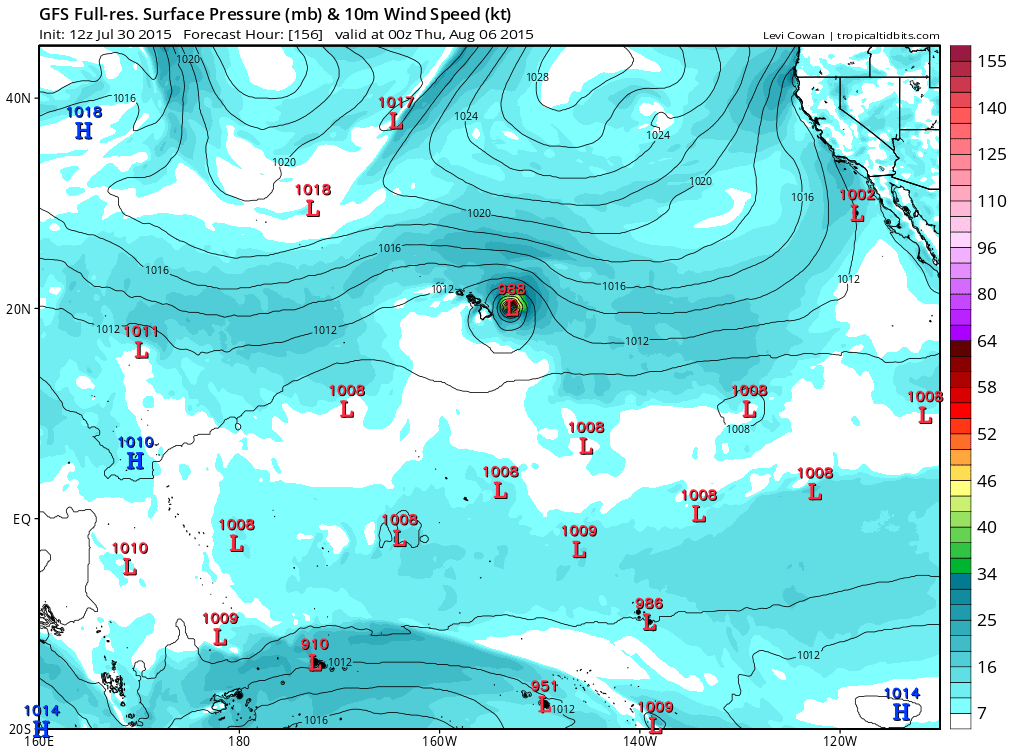
The 12Z GFS suggests Guillermo may pass just WNW of Hilo.
0 likes
Carla/Alicia/Jerry(In The Eye)/Michelle/Charley/Ivan/Dennis/Katrina/Rita/Wilma/Ike/Harvey
Member: National Weather Association
Wx Infinity Forums
http://wxinfinity.com/index.php
Facebook.com/WeatherInfinity
Twitter @WeatherInfinity
Member: National Weather Association
Wx Infinity Forums
http://wxinfinity.com/index.php
Facebook.com/WeatherInfinity
Twitter @WeatherInfinity
-
Kingarabian
- S2K Supporter
- Posts: 16348
- Joined: Sat Aug 08, 2009 3:06 am
- Location: Honolulu, Hawaii
Who is online
Users browsing this forum: No registered users and 80 guests