TPPN10 PGTW 252137
A. TYPHOON 21W (DUJUAN)
B. 25/2032Z
C. 20.78N
D. 130.68E
E. FIVE/MTSAT
F. T5.0/5.0/D2.0/24HRS STT: D0.5/03HRS
G. IR/EIR
H. REMARKS: 34A/PBO LARGE EYE/ANMTN. WMG EYE SURROUNDED BY LG
(ADDED 0.5 ADJUSTMENT FOR B) YIELDS A DT OF 5.5. MET YIELDS A
4.5, WHILE PT YIELDS A 5.0. DBO PT.
I. ADDITIONAL POSITIONS:
25/1638Z 20.20N 131.22E ATMS
25/1704Z 20.17N 131.13E AMS2
25/1802Z 20.40N 130.98E MMHS
25/1827Z 20.45N 130.95E SSMI
CHAPPOTIN
TXPQ22 KNES 252125
TCSWNP
A. 21W (DUJUAN)
B. 25/2032Z
C. 20.8N
D. 130.8E
E. ONE/MTSAT
F. T5.0/5.0/D1.5/24HRS
G. IR/EIR/SWIR
H. REMARKS...SYSTEM HAS DEVELOPED RAPIDLY WITH DT=6.0 BASED ON WARM
MEDIUM GRAY EYE EMBEDDED IN LIGHT GRAY AND SURROUNDED BY BLACK. MET=5.0
ON FAST CURVE AND PAT=5.0. SYSTEM HELD TO DEVELOPMENT OF 1.0 OVER 6HRS
SO FT IS BASED ON PT.
I. ADDL POSITIONS
NIL
...SWANSON
WPAC: DUJUAN - Post-Tropical
Moderator: S2k Moderators
-
Yellow Evan

- Professional-Met

- Posts: 16231
- Age: 27
- Joined: Fri Jul 15, 2011 12:48 pm
- Location: Henderson, Nevada/Honolulu, HI
- Contact:
-
1900hurricane

- Category 5

- Posts: 6063
- Age: 34
- Joined: Fri Feb 06, 2015 12:04 pm
- Location: Houston, TX
- Contact:
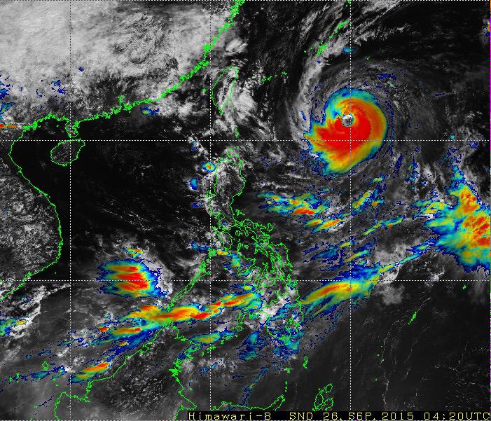
The northern tops are warming up again. Not sure if it's a structural issue (eyewall not yet complete) or an environmental one (dry air entrainment or poor divergence aloft over that quadrant). The southern part of the CDO remains very cold, even in full-on daylight.

0 likes
Contract Meteorologist. TAMU & MSST. Fiercely authentic, one of a kind. We are all given free will, so choose a life meant to be lived. We are the Masters of our own Stories.
Opinions expressed are mine alone.
Follow me on Twitter at @1900hurricane : Read blogs at https://1900hurricane.wordpress.com/
Opinions expressed are mine alone.
Follow me on Twitter at @1900hurricane : Read blogs at https://1900hurricane.wordpress.com/
-
euro6208
Re: WPAC: DUJUAN - Typhoon
WDPN31 PGTW 260300
MSGID/GENADMIN/JOINT TYPHOON WRNCEN PEARL HARBOR HI//
SUBJ/PROGNOSTIC REASONING FOR TYPHOON 21W (DUJUAN) WARNING NR 18//
RMKS/
1. FOR METEOROLOGISTS.
2. 6 HOUR SUMMARY AND ANALYSIS.
TYPHOON (TY) 21W (DUJUAN), LOCATED APPROXIMATELY 361 NM SOUTH-
SOUTHEAST OF KADENA AB, HAS TRACKED NORTHWESTWARD AT 09 KNOTS
OVER THE PAST SIX HOURS. RECENT ANIMATED MSI SHOWS TIGHTLY WRAPPED
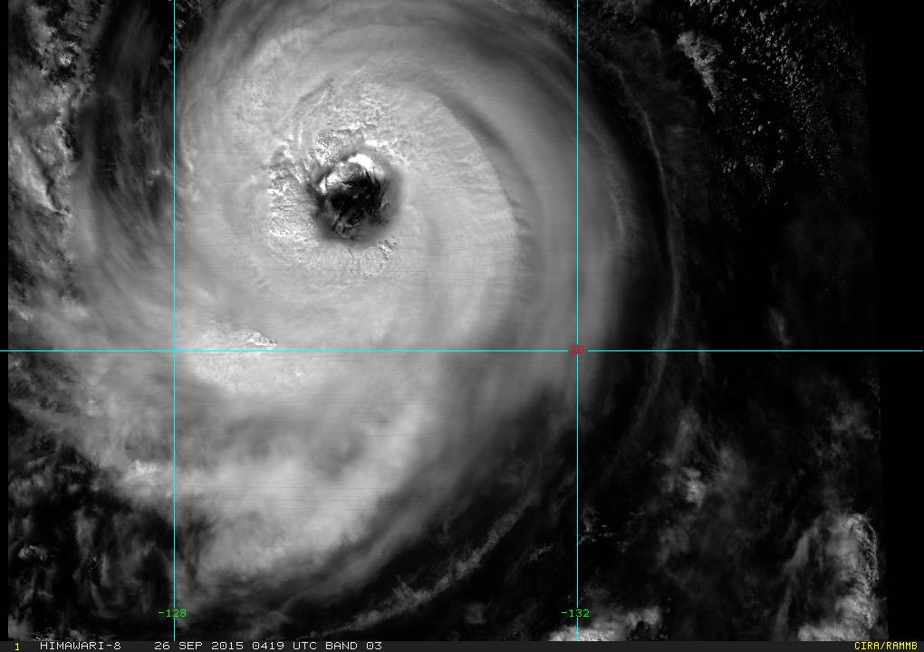
CURVED BANDING INTO A LARGE 33-NM DIAMETER EYE. THIS LEADS TO HIGH
CONFIDENCE IN THE INITIAL POSITION. THE INITIAL INTENSITY HAS BEEN
RAISED TO 90 KNOTS BASED ON DVORAK INTENSITY ESTIMATES FROM ALL
AGENCIES. UPPER-LEVEL ANALYSIS INDICATES TY 21W REMAINS IN A
FAVORABLE ENVIRONMENT WITH LOW VWS BEING OFFSET BY GOOD OUTFLOW. TY
DUJUAN IS TRACKING SLOWLY ALONG THE SOUTHWESTERN PERIPHERY OF A DEEP
LAYERED STR.
3. FORECAST REASONING.
A. NO CHANGE IN THE FORECAST PHILOSOPHY SINCE THE PREVIOUS
PROGNOSTIC REASONING MESSAGE.
B. TY DUJUAN WILL MAINTAIN A NORTHWESTWARD TRACK THROUGH THE END
OF THE FORECAST PERIOD UNDER THE STEERING INFLUENCE OF THE STR. DUE
TO PERSISTENT FAVORABLE ENVIRONMENTAL CHARACTERISTICS TO INCLUDE LOW
VWS, GOOD OHC AND GOOD OUTFLOW ALOFT, EXPECT CONTINUED
INTENSIFICATION THROUGH TAU 36 AT A CLIMATOLOGICAL RATE WITH A PEAK
OF 115 KNOTS. HOWEVER, BEYOND TAU 48, EXPECT TY DUJUAN TO BEGIN TO
WEAKEN DUE TO LOWER OHC, AN INCREASE IN VWS AND LAND INTERACTION
WITH THE MOUNTAINOUS TERRAIN OF TAIWAN. DUE TO THE HIGH LIKELIHOOD
OF A LEEWARD JUMP SCENARIO BETWEEN TAU 48 AND 72, THERE IS LIMITED
CONFIDENCE IN THE TAU 72 POSITION.
C. TY 21W WILL DISSIPATE SIGNIFICANTLY AS IT MAKES LANDFALL IN
CHINA THROUGH THE EXTENDED FORECAST. DYNAMIC MODEL GUIDANCE IS IN
FAIRLY GOOD AGREEMENT THROUGHOUT THE FORECAST LEADING TO HIGH
CONFIDENCE IN THE JTWC FORECAST TRACK.//
NNNN
MSGID/GENADMIN/JOINT TYPHOON WRNCEN PEARL HARBOR HI//
SUBJ/PROGNOSTIC REASONING FOR TYPHOON 21W (DUJUAN) WARNING NR 18//
RMKS/
1. FOR METEOROLOGISTS.
2. 6 HOUR SUMMARY AND ANALYSIS.
TYPHOON (TY) 21W (DUJUAN), LOCATED APPROXIMATELY 361 NM SOUTH-
SOUTHEAST OF KADENA AB, HAS TRACKED NORTHWESTWARD AT 09 KNOTS
OVER THE PAST SIX HOURS. RECENT ANIMATED MSI SHOWS TIGHTLY WRAPPED
CURVED BANDING INTO A LARGE 33-NM DIAMETER EYE. THIS LEADS TO HIGH
CONFIDENCE IN THE INITIAL POSITION. THE INITIAL INTENSITY HAS BEEN
RAISED TO 90 KNOTS BASED ON DVORAK INTENSITY ESTIMATES FROM ALL
AGENCIES. UPPER-LEVEL ANALYSIS INDICATES TY 21W REMAINS IN A
FAVORABLE ENVIRONMENT WITH LOW VWS BEING OFFSET BY GOOD OUTFLOW. TY
DUJUAN IS TRACKING SLOWLY ALONG THE SOUTHWESTERN PERIPHERY OF A DEEP
LAYERED STR.
3. FORECAST REASONING.
A. NO CHANGE IN THE FORECAST PHILOSOPHY SINCE THE PREVIOUS
PROGNOSTIC REASONING MESSAGE.
B. TY DUJUAN WILL MAINTAIN A NORTHWESTWARD TRACK THROUGH THE END
OF THE FORECAST PERIOD UNDER THE STEERING INFLUENCE OF THE STR. DUE
TO PERSISTENT FAVORABLE ENVIRONMENTAL CHARACTERISTICS TO INCLUDE LOW
VWS, GOOD OHC AND GOOD OUTFLOW ALOFT, EXPECT CONTINUED
INTENSIFICATION THROUGH TAU 36 AT A CLIMATOLOGICAL RATE WITH A PEAK
OF 115 KNOTS. HOWEVER, BEYOND TAU 48, EXPECT TY DUJUAN TO BEGIN TO
WEAKEN DUE TO LOWER OHC, AN INCREASE IN VWS AND LAND INTERACTION
WITH THE MOUNTAINOUS TERRAIN OF TAIWAN. DUE TO THE HIGH LIKELIHOOD
OF A LEEWARD JUMP SCENARIO BETWEEN TAU 48 AND 72, THERE IS LIMITED
CONFIDENCE IN THE TAU 72 POSITION.
C. TY 21W WILL DISSIPATE SIGNIFICANTLY AS IT MAKES LANDFALL IN
CHINA THROUGH THE EXTENDED FORECAST. DYNAMIC MODEL GUIDANCE IS IN
FAIRLY GOOD AGREEMENT THROUGHOUT THE FORECAST LEADING TO HIGH
CONFIDENCE IN THE JTWC FORECAST TRACK.//
NNNN
0 likes
-
1900hurricane
- Category 5
- Posts: 6063
- Age: 34
- Joined: Fri Feb 06, 2015 12:04 pm
- Location: Houston, TX
- Contact:
Still waiting for the NW quad to fill in convectively. It's trying though.
0 likes
Contract Meteorologist. TAMU & MSST. Fiercely authentic, one of a kind. We are all given free will, so choose a life meant to be lived. We are the Masters of our own Stories.
Opinions expressed are mine alone.
Follow me on Twitter at @1900hurricane : Read blogs at https://1900hurricane.wordpress.com/
Opinions expressed are mine alone.
Follow me on Twitter at @1900hurricane : Read blogs at https://1900hurricane.wordpress.com/

-
euro6208
Re: WPAC: DUJUAN - Typhoon
UW - CIMSS
ADVANCED DVORAK TECHNIQUE
ADT-Version 8.2.1
Tropical Cyclone Intensity Algorithm
----- Current Analysis -----
Date : 26 SEP 2015 Time : 133000 UTC
Lat : 22:03:22 N Lon : 128:42:02 E
CI# /Pressure/ Vmax
6.1 / 935.4mb/117.4kt
Final T# Adj T# Raw T#
6.1 6.7 6.7
Estimated radius of max. wind based on IR : 33 km
Center Temp : +13.5C Cloud Region Temp : -76.5C
Scene Type : EYE
Positioning Method : RING/SPIRAL COMBINATION
Ocean Basin : WEST PACIFIC
Dvorak CI > MSLP Conversion Used : CKZ Method
Tno/CI Rules : Constraint Limits : NO LIMIT
Weakening Flag : OFF
Rapid Dissipation Flag : OFF
C/K/Z MSLP Estimate Inputs :
- Average 34 knot radii : 136km
- Environmental MSLP : 1004mb
Satellite Name : MTSAT2
Satellite Viewing Angle : 31.7 degrees
0 likes
-
Yellow Evan
- Professional-Met
- Posts: 16231
- Age: 27
- Joined: Fri Jul 15, 2011 12:48 pm
- Location: Henderson, Nevada/Honolulu, HI
- Contact:
I'm sick of the JTWC doing this.
TPPN10 PGTW 261205
A. TYPHOON 21W (DUJUAN)
B. 26/1132Z
C. 21.92N
D. 128.88E
E. FIVE/MTSAT
F. T5.0/5.0/D0.5/24HRS STT: D0.5/03HRS
G. IR/EIR
H. REMARKS: 34A/PBO LARGE EYE/ANMTN. WMG SURR BY LG (+1.0 ADJ
FOR BLK) YIELDS A DT OF 6.0. PT YIELDS A 5.0 WHILE MET YIELDS A
5.5. [b]DBO PT DUE TO DT FLUCTUATION AND UNCERTAINTY.[b/]
I. ADDITIONAL POSITIONS:
26/0733Z 21.50N 129.57E SSMS
26/0911Z 21.62N 129.45E SSMS
MARTINEZ
What's so uncertain? It either meets the width requirement or it doesn't Also don't know why PT is 5.0.
Depending on which frame you chose this is either a 5.5, 6.0, or 6.5.
26/0832 UTC 22.0N 129.3E T4.5/5.0 DUJUAN -- West Pacific
Also don't know what SAB is thinking, but that fix is old. Based on a blend of Data T numbers from JTWC and ADT, I'd go with 120 knots.
0 likes
-
euro6208
Re: WPAC: DUJUAN - Typhoon
Just relax guys, remember JTWC is unofficial and JMA is your official agency. JMA only have this at a mere 75 knots 10 min... 
0 likes
-
euro6208
Re: WPAC: DUJUAN - Typhoon

WDPN31 PGTW 261500
MSGID/GENADMIN/JOINT TYPHOON WRNCEN PEARL HARBOR HI//
SUBJ/PROGNOSTIC REASONING FOR TYPHOON 21W (DUJUAN) WARNING NR 20//
RMKS//
1. FOR METEOROLOGISTS.
2. 6 HOUR SUMMARY AND ANALYSIS.
TYPHOON (TY) 21W (DUJUAN), LOCATED APPROXIMATELY 282 NM SOUTH-
SOUTHEAST OF KADENA AB, JAPAN HAS TRACKED NORTHWESTWARD AT
09 KNOTS OVER THE PAST SIX HOURS. ANIMATED ENHANCED INFRARED
SATELLITE IMAGERY SHOWS AN IMPROVED CONVECTIVE CORE STRUCTURE WITH
COOLER CLOUD TOPS SURROUNDING A LARGE 38NM EYE WHICH SUPPORTS THE
INITIAL POSITION WITH HIGH CONFIDENCE. THE WATER VAPOR LOOP SHOWS A
MORE SYMMETRIC CORE STRUCTURE WITH DECREASED DRY AIR IMPACTING THE
TYPHOON. A 261230Z AMSU-B MICROWAVE IMAGE SHOWS A CLOSED OFF
MICROWAVE EYE FEATURE SURROUNDED BY AN INTENSE CONVECTIVE CORE. THE
CURRENT INTENSITY HAS BEEN INCREASED TO 95 KNOTS BASED ON AN
ASSESSMENT OF DVORAK INTENSITY ESTIMATES FROM ALL AGENCIES AND IS
SUPPORTED BY A RECENT SATCON INTENSITY ESTIMATE OF 97 KNOTS.
ENVIRONMENTAL ANALYSIS INDICATES AN IMPROVED ENVIRONMENT WITH NEAR
RADIAL OUTFLOW AND LOW VERTICAL WIND SHEAR (VWS). TY DUJUAN IS
TRACKING ALONG THE SOUTHWESTERN PERIPHERY OF A DEEP LAYERED SUB-
TROPICAL RIDGE.
3. FORECAST REASONING.
A. NO CHANGE IN THE FORECAST PHILOSOPHY SINCE THE PREVIOUS
PROGNOSTIC REASONING MESSAGE.
B. TY DUJUAN WILL MAINTAIN A WEST-NORTHWESTWARD TRAJECTORY
THROUGHOUT THE FORECAST PERIOD AS THE STEERING STR CONTINUES TO
BUILD OVER THE SYSTEM. CURRENT ENVIRONMENTAL CONDITIONS WILL SUPPORT
A SLIGHT INTENSIFICATION OVER THE NEXT 24 HOURS. BEYOND TAU 24, TY
21W WILL BEGIN TO WEAKEN DUE TO LOWER OHC VALUES, AN INCREASE IN
VWS AND LAND INTERACTION WITH THE MOUNTAINOUS TERRAIN OF TAIWAN. DUE
TO THE HIGH LIKELIHOOD OF A LEEWARD JUMP SCENARIO AS THE TYPHOON
PASSES THROUGH TAIWAN, THERE IS LIMITED CONFIDENCE IN THE TAU 72
POSITION.
C. IN THE EXTENDED FORECAST, TY 21W WILL MAKE A SECOND LANDFALL
ALONG THE COAST OF CHINA AND WILL RAPIDLY DISSIPATE BY THE END OF
THE FORECAST PERIOD. DYNAMIC MODEL GUIDANCE IS IN GOOD AGREEMENT
THROUGHOUT THE FORECAST PERIOD WITH A SPREAD OF 130NM AT TAU 48 JUST
PRIOR TO LANDFALL OVER TAIWAN. THIS TIGHT MODEL AGREEMENT LEADS TO
HIGH CONFIDENCE IN THE JTWC FORECAST TRACK.//
NNNN
0 likes
-
euro6208
Re: WPAC: DUJUAN - Typhoon
Trying to wrap deeper convection around it's eye especially in the northern side. Looks like it's almost there.

0 likes
-
Yellow Evan
- Professional-Met
- Posts: 16231
- Age: 27
- Joined: Fri Jul 15, 2011 12:48 pm
- Location: Henderson, Nevada/Honolulu, HI
- Contact:
Re: WPAC: DUJUAN - Typhoon
euro6208 wrote:Just relax guys, remember JTWC is unofficial and JMA is your official agency. JMA only have this at a mere 75 knots 10 min...
which means they likely have a DT of 4.5.
I doubt this, but if this storm can warp around the whites (on BD) at .5 of a degree in thickness, this reaches T7.0.
0 likes
-
Yellow Evan
- Professional-Met
- Posts: 16231
- Age: 27
- Joined: Fri Jul 15, 2011 12:48 pm
- Location: Henderson, Nevada/Honolulu, HI
- Contact:
Already what is this crap? The LG is thick enough clearly and the small MG spot should be disregarded as the LG is still thick enough behind the MG spot.
TPPN10 PGTW 261530
A. TYPHOON 21W (DUJUAN)
B. 26/1432Z
C. 22.13N
D. 128.57E
E. FIVE/MTSAT
F. T5.0/5.0/D1.0/24HRS STT: S0.0/03HRS
G. IR/EIR
H. REMARKS: 34A/PBO LARGE EYE/ANMTN. WMG EYE SURR BY MG (+0.5
ADJ LG) YIELDS A DT OF 5.0. PT AND MET AGREE. DBO DT.
I. ADDITIONAL POSITIONS:
26/1230Z 21.98N 128.90E MMHS
MARTINEZ
WP, 21, 201509261501, 10, DVTS, CI, , 2220N, 12840E, , 2, 90, 2, , , , , , , , , , , , , , , , , W, KNES, GS, IM, 3, 5050 /////, , , MTSAT, CSC, T, DT=5.5 BO EYE MET=5.0 PT=5.0 FTBO PT
Why is PT even 5.0 and why is SAB basing it off PT?
0 likes
-
1900hurricane
- Category 5
- Posts: 6063
- Age: 34
- Joined: Fri Feb 06, 2015 12:04 pm
- Location: Houston, TX
- Contact:
With the trough to the north being as flat as it is, Dujuan should be running near the ridge axis all the way to Taiwan, keeping it south of the mid-latitude westerly shear just to the north. Barring any structural issues or dry air entrainment, it's possible that Dujuan could strengthen all the way up to landfall.

0 likes
Contract Meteorologist. TAMU & MSST. Fiercely authentic, one of a kind. We are all given free will, so choose a life meant to be lived. We are the Masters of our own Stories.
Opinions expressed are mine alone.
Follow me on Twitter at @1900hurricane : Read blogs at https://1900hurricane.wordpress.com/
Opinions expressed are mine alone.
Follow me on Twitter at @1900hurricane : Read blogs at https://1900hurricane.wordpress.com/
-
1900hurricane
- Category 5
- Posts: 6063
- Age: 34
- Joined: Fri Feb 06, 2015 12:04 pm
- Location: Houston, TX
- Contact:
Also worth noting that convection is really wrapping around the west side now. Himawari-8 is also showing the warm medium greys returning to the eye. Even if the lower resolution MTSAT-2 doesn't pick up on that, an off-white eye embedded in black would yield a DT of 6.0. With the next sat fixes coming up within the hour, it'll be interesting to see what the agencies do.

0 likes
Contract Meteorologist. TAMU & MSST. Fiercely authentic, one of a kind. We are all given free will, so choose a life meant to be lived. We are the Masters of our own Stories.
Opinions expressed are mine alone.
Follow me on Twitter at @1900hurricane : Read blogs at https://1900hurricane.wordpress.com/
Opinions expressed are mine alone.
Follow me on Twitter at @1900hurricane : Read blogs at https://1900hurricane.wordpress.com/
-
Yellow Evan
- Professional-Met
- Posts: 16231
- Age: 27
- Joined: Fri Jul 15, 2011 12:48 pm
- Location: Henderson, Nevada/Honolulu, HI
- Contact:
-
1900hurricane
- Category 5
- Posts: 6063
- Age: 34
- Joined: Fri Feb 06, 2015 12:04 pm
- Location: Houston, TX
- Contact:
Yeah, I was going more for a minimum DT value, but the warm medium grey has started to appear in the eye even on MTSAT, which would push the DT up to 6.5 if the black can be maintained until 1732Z (which based on the faster updating Himawari imagery looks like a no-brainer).
As far as PT being 5.0, it has to do with the large eye screening mentioned in the sat fix above (not that I necessarily agree with it).

As far as PT being 5.0, it has to do with the large eye screening mentioned in the sat fix above (not that I necessarily agree with it).
Last edited by 1900hurricane on Sat Sep 26, 2015 12:27 pm, edited 1 time in total.
0 likes
Contract Meteorologist. TAMU & MSST. Fiercely authentic, one of a kind. We are all given free will, so choose a life meant to be lived. We are the Masters of our own Stories.
Opinions expressed are mine alone.
Follow me on Twitter at @1900hurricane : Read blogs at https://1900hurricane.wordpress.com/
Opinions expressed are mine alone.
Follow me on Twitter at @1900hurricane : Read blogs at https://1900hurricane.wordpress.com/
-
Yellow Evan
- Professional-Met
- Posts: 16231
- Age: 27
- Joined: Fri Jul 15, 2011 12:48 pm
- Location: Henderson, Nevada/Honolulu, HI
- Contact:
-
1900hurricane
- Category 5
- Posts: 6063
- Age: 34
- Joined: Fri Feb 06, 2015 12:04 pm
- Location: Houston, TX
- Contact:
Yeah, it's from the 1973 Dvorak paper, but I think the point is still valid that PT for large eyes are capped. I don't have a problem with it, but I think using a large eye PT in this situation is not the way to go.
0 likes
Contract Meteorologist. TAMU & MSST. Fiercely authentic, one of a kind. We are all given free will, so choose a life meant to be lived. We are the Masters of our own Stories.
Opinions expressed are mine alone.
Follow me on Twitter at @1900hurricane : Read blogs at https://1900hurricane.wordpress.com/
Opinions expressed are mine alone.
Follow me on Twitter at @1900hurricane : Read blogs at https://1900hurricane.wordpress.com/
Who is online
Users browsing this forum: No registered users and 62 guests