Seasonal Indicators (Beyond Day 16): Instability / SST's / MSLP / Steering / Sal

This is the general tropical discussion area. Anyone can take their shot at predicting a storms path.

Moderator: S2k Moderators

Forum rules

The posts in this forum are NOT official forecasts and should not be used as such. They are just the opinion of the poster and may or may not be backed by sound meteorological data. They are NOT endorsed by any professional institution or STORM2K. For official information, please refer to products from the National Hurricane Center and National Weather Service.

Help Support Storm2K
Message
Author
User avatar
wxman57
Moderator-Pro Met
Moderator-Pro Met
Posts: 22979
Age: 67
Joined: Sat Jun 21, 2003 8:06 pm
Location: Houston, TX (southwest)

Re: 2016 indicators: Instability / SST's / MSLP / Steering / Sal

#101 Postby wxman57 » Fri Mar 25, 2016 1:13 pm

Turns out the CFSv2 had a major problem. If you recall, it was about the only model forecasting a strengthening El Nino by fall. The problem is described in NCEP's PowerPoint, below. They're initiating a fix at 06Z Monday. The program will be re-run, likely showing the results on the right (Experimental) in the bottom image (neutral to La-Nina vs. strengthening El Nino). Turns out "garbage-in" does equal "garbage-out"...

See the PowerPoint slides here:
https://t.co/SpGncnWXMU

Image

Image
0 likes   

hcane27
Tropical Storm
Tropical Storm
Posts: 231
Joined: Tue Jan 31, 2006 7:33 pm

Re: 2016 indicators: Instability / SST's / MSLP / Steering / Sal

#102 Postby hcane27 » Fri Mar 25, 2016 1:59 pm

GIGOAMS (Garbage In Garbage Out At Machine Speed)
0 likes   

User avatar
SFLcane
S2K Supporter
S2K Supporter
Posts: 10163
Age: 47
Joined: Sat Jun 05, 2010 1:44 pm
Location: Lake Worth Florida

Re: 2016 indicators: Instability / SST's / MSLP / Steering / Sal

#103 Postby SFLcane » Fri Mar 25, 2016 4:29 pm

Sooooo...wxman57, does this mean an increase in number of storms this yr? I for one do think this season will surprise a few hope those hurricane preps get done.
0 likes   

User avatar
wxman57
Moderator-Pro Met
Moderator-Pro Met
Posts: 22979
Age: 67
Joined: Sat Jun 21, 2003 8:06 pm
Location: Houston, TX (southwest)

Re: 2016 indicators: Instability / SST's / MSLP / Steering / Sal

#104 Postby wxman57 » Fri Mar 25, 2016 5:47 pm

SFLcane wrote:Sooooo...wxman57, does this mean an increase in number of storms this yr? I for one do think this season will surprise a few hope those hurricane preps get done.


Well, neutral to La Nina conditions would certainly be more favorable than a strengthening El Nino. There are other factors, though.
0 likes   

WeatherEmperor
S2K Supporter
S2K Supporter
Posts: 4806
Age: 41
Joined: Thu Sep 04, 2003 2:54 pm
Location: South Florida

Re: 2016 indicators: Instability / SST's / MSLP / Steering / Sal

#105 Postby WeatherEmperor » Fri Mar 25, 2016 6:19 pm

I still want to see how the Pdo behaves. Also, wasnt it the Euro that was forecasting slightly higher than normal sea level pressures? I believe the latest forecast is not as bad as last year but still interesting
0 likes   

User avatar
cycloneye
Admin
Admin
Posts: 145333
Age: 68
Joined: Thu Oct 10, 2002 10:54 am
Location: San Juan, Puerto Rico

Re: 2016 indicators: Instability / SST's / MSLP / Steering / Sal

#106 Postby cycloneye » Fri Mar 25, 2016 7:14 pm

WeatherEmperor wrote:I still want to see how the Pdo behaves. Also, wasnt it the Euro that was forecasting slightly higher than normal sea level pressures? I believe the latest forecast is not as bad as last year but still interesting


This is the ECMWF MSLP forecast for July,August and September and does not look good if is right.

Image
0 likes   
Visit the Caribbean-Central America Weather Thread where you can find at first post web cams,radars
and observations from Caribbean basin members Click Here

User avatar
Kingarabian
S2K Supporter
S2K Supporter
Posts: 15981
Joined: Sat Aug 08, 2009 3:06 am
Location: Honolulu, Hawaii

Re: 2016 indicators: Instability / SST's / MSLP / Steering / Sal

#107 Postby Kingarabian » Fri Mar 25, 2016 9:51 pm

cycloneye wrote:
WeatherEmperor wrote:I still want to see how the Pdo behaves. Also, wasnt it the Euro that was forecasting slightly higher than normal sea level pressures? I believe the latest forecast is not as bad as last year but still interesting


This is the ECMWF MSLP forecast for July,August and September and does not look good if is right.


Interesting that the latest Euro is now forecasting even higher pressures across the MDR/GOM and lower pressures across the Pacific. Also a cause of concern for me with those blue's around/near Hawaii. Especially since this upcoming season has a good analog with 92.
0 likes   
RIP Kobe Bryant

User avatar
WPBWeather
S2K Supporter
S2K Supporter
Posts: 535
Age: 67
Joined: Thu Jul 18, 2013 12:33 pm

Re: 2016 indicators: Instability / SST's / MSLP / Steering / Sal

#108 Postby WPBWeather » Fri Mar 25, 2016 10:17 pm

What all this might also mean is that from the 2016 National Hurricane Conference just concluded is that the Euro along with other models have definite issues with accurate forecasts from year to year--and that each model may fail from storm to storm. These issues might be model design problems OR bad data input--as with the recent CFS errors.

2016 will be an interesting year for both the PAC and ATL.
0 likes   

User avatar
wxman57
Moderator-Pro Met
Moderator-Pro Met
Posts: 22979
Age: 67
Joined: Sat Jun 21, 2003 8:06 pm
Location: Houston, TX (southwest)

Re: 2016 indicators: Instability / SST's / MSLP / Steering / Sal

#109 Postby wxman57 » Sat Mar 26, 2016 11:09 am

The Euro is indicating lower pressures across the Atlantic for peak season than it was last year at this time. Conditions, in general, should be more favorable across the tropics than last season, particularly across the Caribbean & Gulf of Mexico.

Comparison of the EC's forecast this March (top) to last March (bottom). Quite a difference in the East Pac, and lower pressure in the Atlantic:

Image
0 likes   

User avatar
SFLcane
S2K Supporter
S2K Supporter
Posts: 10163
Age: 47
Joined: Sat Jun 05, 2010 1:44 pm
Location: Lake Worth Florida

Re: 2016 indicators: Instability / SST's / MSLP / Steering / Sal

#110 Postby SFLcane » Sat Mar 26, 2016 1:38 pm

Ah yes that's my kinda talk wxman57 :clap:
0 likes   

User avatar
Kingarabian
S2K Supporter
S2K Supporter
Posts: 15981
Joined: Sat Aug 08, 2009 3:06 am
Location: Honolulu, Hawaii

Re: 2016 indicators: Instability / SST's / MSLP / Steering / Sal

#111 Postby Kingarabian » Sat Mar 26, 2016 2:41 pm

wxman57 wrote:The Euro is indicating lower pressures across the Atlantic for peak season than it was last year at this time. Conditions, in general, should be more favorable across the tropics than last season, particularly across the Caribbean & Gulf of Mexico.

Comparison of the EC's forecast this March (top) to last March (bottom). Quite a difference in the East Pac, and lower pressure in the Atlantic:


But wasn't the Euro showing even lower pressures last month?

Image
0 likes   
RIP Kobe Bryant

Alyono
Professional-Met
Professional-Met
Posts: 6961
Joined: Fri Apr 26, 2013 3:52 pm
Location: Texas Coast

Re: 2016 indicators: Instability / SST's / MSLP / Steering / Sal

#112 Postby Alyono » Sat Mar 26, 2016 6:34 pm

It's not SW of Baja that will be the big factor for the Atlantic. It's the area between 10-20N south and EAST of the Baja that the EC has a strong precip anomaly. That will simply blast shear through the Caribbean, along with sinking air
0 likes   

User avatar
Hurricaneman
Category 5
Category 5
Posts: 7351
Age: 45
Joined: Tue Aug 31, 2004 3:24 pm
Location: central florida

Re: 2016 indicators: Instability / SST's / MSLP / Steering / Sal

#113 Postby Hurricaneman » Sat Mar 26, 2016 10:34 pm

It seems as though the SSTAs in the PDO have taken a drop between the start of the month to now, what if anything would this do to the hurricanes season if that should flip to a negative number

http://www.ospo.noaa.gov/data/sst/anoma ... 3.2016.gif

http://www.ospo.noaa.gov/data/sst/anoma ... 4.2016.gif

The posts in this forum are NOT official forecast and should not be used as such. They are just the opinion of the poster and may or may not be backed by sound meteorological data. They are NOT endorsed by any professional institution or storm2k.org. For official information, please refer to the NHC and NWS products
0 likes   

User avatar
Kingarabian
S2K Supporter
S2K Supporter
Posts: 15981
Joined: Sat Aug 08, 2009 3:06 am
Location: Honolulu, Hawaii

Re: 2016 indicators: Instability / SST's / MSLP / Steering / Sal

#114 Postby Kingarabian » Sun Mar 27, 2016 12:29 am

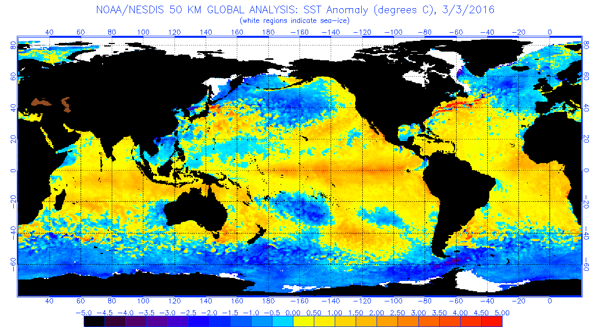
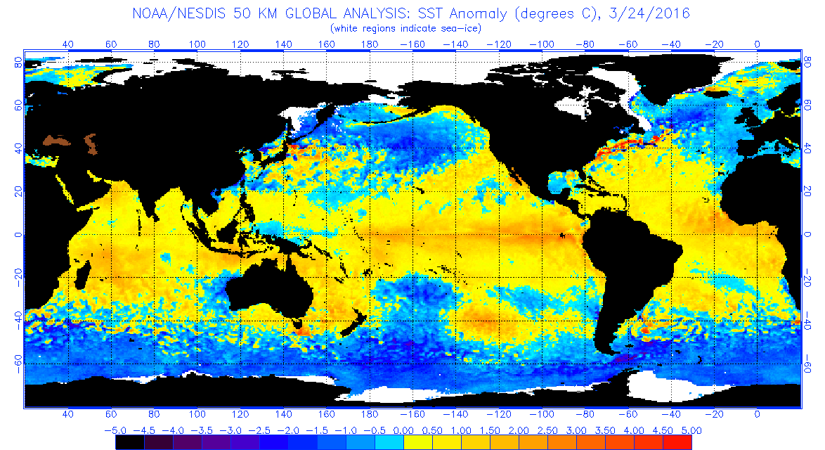
Hurricaneman wrote:It seems as though the SSTAs in the PDO have taken a drop between the start of the month to now, what if anything would this do to the hurricanes season if that should flip to a negative number

http://www.ospo.noaa.gov/data/sst/anoma ... 3.2016.gif

http://www.ospo.noaa.gov/data/sst/anoma ... 4.2016.gif

The posts in this forum are NOT official forecast and should not be used as such. They are just the opinion of the poster and may or may not be backed by sound meteorological data. They are NOT endorsed by any professional institution or storm2k.org. For official information, please refer to the NHC and NWS products

It's hard to guage the PDO based on eyeball estimations. We don't what they use to calculate the PDO. Lots of times it looked like the PDO weakened but in turn it strengthened, and vice versa.
0 likes   
RIP Kobe Bryant

User avatar
Darvince
Tropical Storm
Tropical Storm
Posts: 184
Joined: Wed Sep 02, 2015 10:25 pm
Location: Phoenix AZ

Re: 2016 indicators: Instability / SST's / MSLP / Steering / Sal

#115 Postby Darvince » Sun Mar 27, 2016 10:02 pm

That doesn't look like the PDO is weakening, although it is a bit odd. The PDO weakening would involve the SSTAs in the region 170-150W and 30N-50N warming up and the warm anomalies dissipating.
0 likes   
:craz:

User avatar
Hurricaneman
Category 5
Category 5
Posts: 7351
Age: 45
Joined: Tue Aug 31, 2004 3:24 pm
Location: central florida

Re: 2016 indicators: Instability / SST's / MSLP / Steering / Sal

#116 Postby Hurricaneman » Sun Mar 27, 2016 10:31 pm

Another area IMO to look at is the Area of the Atlantic between 5N to 10S as if those numbers are negative there seems to be stronger mor robust tropical waves while if those numbers are positive it causes the waves to be weaker also might have something to do with vertical instability in the MDR as it tends to be higher with the negative anomalies in that area.

The posts in this forum are NOT official forecast and should not be used as such. They are just the opinion of the poster and may or may not be backed by sound meteorological data. They are NOT endorsed by any professional institution or storm2k.org. For official information, please refer to the NHC and NWS products
0 likes   

User avatar
cycloneye
Admin
Admin
Posts: 145333
Age: 68
Joined: Thu Oct 10, 2002 10:54 am
Location: San Juan, Puerto Rico

Re: 2016 indicators: Instability / SST's / MSLP / Steering / Sal

#117 Postby cycloneye » Thu Mar 31, 2016 7:00 pm

Very cold North Atlantic that may have negative implications to MDR as Dr Klotzbach mentions many times.

Image
0 likes   
Visit the Caribbean-Central America Weather Thread where you can find at first post web cams,radars
and observations from Caribbean basin members Click Here

User avatar
WPBWeather
S2K Supporter
S2K Supporter
Posts: 535
Age: 67
Joined: Thu Jul 18, 2013 12:33 pm

Re: 2016 indicators: Instability / SST's / MSLP / Steering / Sal

#118 Postby WPBWeather » Thu Mar 31, 2016 8:42 pm

:uarrow: I think he backed off a bit on the cold spot in the MDR, but we shall see.
0 likes   

User avatar
TheAustinMan
Category 5
Category 5
Posts: 1047
Age: 25
Joined: Mon Jul 08, 2013 4:26 pm
Location: United States
Contact:

Re: 2016 indicators: Instability / SST's / MSLP / Steering / Sal

#119 Postby TheAustinMan » Thu Mar 31, 2016 9:21 pm

The CanSIPS (that is, the Canadian Seasonal to Interannual Prediction System) has completed its April run. Below are some SST forecast maps from CanSIPS, but you can view other variables and the rest of the run at TropicalTidbits

June 2016 Global Sea Surface Temperatures, CanSIPS
Image

September 2016 Global Sea Surface Temperatures, CanSIPS
Image
0 likes   
ImageImageImage
Treat my opinions with a grain of salt. For official information see your local weather service.

Alyono
Professional-Met
Professional-Met
Posts: 6961
Joined: Fri Apr 26, 2013 3:52 pm
Location: Texas Coast

Re: 2016 indicators: Instability / SST's / MSLP / Steering / Sal

#120 Postby Alyono » Thu Mar 31, 2016 9:58 pm

the September CanSips is incredibly favorable, after an unfavorable June. That pattern could yield 7-10 Atlantic storms in September

Thankfully, it is the Canadian
0 likes   


Return to “Talkin' Tropics”

Who is online

Users browsing this forum: Blown Away, REDHurricane and 70 guests