Possible development in the Western Atlantic / GOM (Is Invest 97L)

This is the general tropical discussion area. Anyone can take their shot at predicting a storms path.

Moderator: S2k Moderators

Forum rules

The posts in this forum are NOT official forecasts and should not be used as such. They are just the opinion of the poster and may or may not be backed by sound meteorological data. They are NOT endorsed by any professional institution or STORM2K. For official information, please refer to products from the National Hurricane Center and National Weather Service.

Help Support Storm2K
Message
Author
LarryWx
S2K Supporter
S2K Supporter
Posts: 6300
Joined: Sun Sep 07, 2003 2:04 pm
Location: GA

Re: Possible development in the central Atlantic (0/40)

#101 Postby LarryWx » Sun Jul 28, 2024 8:37 am

ineedsnow wrote:6z GEFS are getting a little more interested in this now


Indeed, just after the least active 0Z run in awhile (only 1 member (3%) with a TC), the 6Z GEFS with 5 TCs from 31 members (16%) is the most active GEFS to this point. All 5 members landfall in the CONUS (4 E coast, 1 FL Keys and panhandle) with 3 of these 5 landfalling twice.
1 likes   
Personal Forecast Disclaimer:
The posts in this forum are NOT official forecasts and should not be used as such. They are just the opinion of the poster and may or may not be backed by sound meteorological data. They are NOT endorsed by any professional institution or storm2k.org. For official information, please refer to the NHC and NWS products.

User avatar
Category5Kaiju
Category 5
Category 5
Posts: 4095
Joined: Thu Dec 24, 2020 12:45 pm
Location: Seattle

Re: Possible development in the central Atlantic (0/40)

#102 Postby Category5Kaiju » Sun Jul 28, 2024 8:46 am

So at least as of now the GEFS likes a more west system while the Euro likes it east. Why is this the case?
0 likes   
Unless explicitly stated, all info in my posts is based on my own opinions and observations. Tropical storms and hurricanes can be extremely dangerous. Do not think you can beat Mother Nature. Refer to an accredited weather research agency or meteorologist if you need to make serious decisions regarding an approaching storm.

User avatar
toad strangler
S2K Supporter
S2K Supporter
Posts: 4543
Joined: Sun Jul 28, 2013 3:09 pm
Location: Earth
Contact:

Re: Possible development in the central Atlantic (0/40)

#103 Postby toad strangler » Sun Jul 28, 2024 9:13 am

LarryWx wrote:
ineedsnow wrote:6z GEFS are getting a little more interested in this now


Indeed, just after the least active 0Z run in awhile (only 1 member (3%) with a TC), the 6Z GEFS with 5 TCs from 31 members (16%) is the most active GEFS to this point. All 5 members landfall in the CONUS (4 E coast, 1 FL Keys and panhandle) with 3 of these 5 landfalling twice.


GEFS seems to be favoring a E solution now inline with the Euro. But really, none of this matters much until an actual closed low/depression develops.
2 likes   

User avatar
SFLcane
S2K Supporter
S2K Supporter
Posts: 10163
Age: 47
Joined: Sat Jun 05, 2010 1:44 pm
Location: Lake Worth Florida

Re: Possible development in the central Atlantic (0/40)

#104 Postby SFLcane » Sun Jul 28, 2024 9:27 am

Image
0 likes   

User avatar
Category5Kaiju
Category 5
Category 5
Posts: 4095
Joined: Thu Dec 24, 2020 12:45 pm
Location: Seattle

Re: Possible development in the central Atlantic (0/40)

#105 Postby Category5Kaiju » Sun Jul 28, 2024 9:30 am


Looks like the ones that become stronger end up more east. Definitely see a fork there.
0 likes   
Unless explicitly stated, all info in my posts is based on my own opinions and observations. Tropical storms and hurricanes can be extremely dangerous. Do not think you can beat Mother Nature. Refer to an accredited weather research agency or meteorologist if you need to make serious decisions regarding an approaching storm.

LarryWx
S2K Supporter
S2K Supporter
Posts: 6300
Joined: Sun Sep 07, 2003 2:04 pm
Location: GA

Re: Possible development in the central Atlantic (0/40)

#106 Postby LarryWx » Sun Jul 28, 2024 9:38 am

6Z EPS 144 is as active, if not more active, vs the 0Z EPS 150 regarding the C MDR wave.
0 likes   
Personal Forecast Disclaimer:
The posts in this forum are NOT official forecasts and should not be used as such. They are just the opinion of the poster and may or may not be backed by sound meteorological data. They are NOT endorsed by any professional institution or storm2k.org. For official information, please refer to the NHC and NWS products.

User avatar
NDG
S2K Supporter
S2K Supporter
Posts: 15446
Joined: Sun Jul 09, 2006 10:14 pm
Location: Orlando, FL

Re: Possible development in the central Atlantic (0/40)

#107 Postby NDG » Sun Jul 28, 2024 9:39 am

As always is the case I can't imagine either the GFS or ECMWF being that wrong. So most likely there will be weak development out of this TW but further west where the EC shows it to be. The CMC is probably a good close consensus between them two.
But one thing for sure is that 7 days ago the GFS forecast was way off for this morning's moisture envelope with it.

Image
0 likes   

jlauderdal
S2K Supporter
S2K Supporter
Posts: 7182
Joined: Wed May 19, 2004 5:46 am
Location: NE Fort Lauderdale
Contact:

Re: Possible development in the central Atlantic (0/40)

#108 Postby jlauderdal » Sun Jul 28, 2024 9:55 am

NDG wrote:As always is the case I can't imagine either the GFS or ECMWF being that wrong. So most likely there will be weak development out of this TW but further west where the EC shows it to be. The CMC is probably a good close consensus between them two.
But one thing for sure is that 7 days ago the GFS forecast was way off for this morning's moisture envelope with it.

https://imagizer.imageshack.com/img923/3797/pNKeJJ.gif

The struggle is real with the modeling in the Tropics this season, expect more big swings until something gets going and that is a few days away.
0 likes   

ChrisH-UK
Category 2
Category 2
Posts: 625
Joined: Sat May 29, 2021 8:22 am

Re: Possible development in the central Atlantic (0/40)

#109 Postby ChrisH-UK » Sun Jul 28, 2024 10:04 am

These are the waves that we are talking about.

Image
0 likes   

User avatar
aspen
Category 5
Category 5
Posts: 8818
Joined: Sat Oct 12, 2019 7:10 pm
Location: Connecticut, USA

Re: Possible development in the central Atlantic (0/40)

#110 Postby aspen » Sun Jul 28, 2024 10:11 am

Something to note about the Euro solutions is how long “future Debby” takes to make its turn to the north. It slows down a lot in that corner of the Atlantic by the Bahamas/just north of the GAs, which’ll give it a few full days over toasty 28-29C *if* this solution verifies, which would be concerning giving its proximity to the East Coast.

Alternatively, the Euro could be far too north in its track forecasts at this point. I remember it was too north with Laura, showing a track just above the GAs and possibly into Florida while the GFS was further south and ended up verifying.
0 likes   
Irene '11 Sandy '12 Hermine '16 5/15/2018 Derecho Fay '20 Isaias '20 Elsa '21 Henri '21 Ida '21

I am only a meteorology enthusiast who knows a decent amount about tropical cyclones. Look to the professional mets, the NHC, or your local weather office for the best information.

User avatar
mpic
S2K Supporter
S2K Supporter
Posts: 622
Joined: Thu Oct 20, 2005 11:24 am
Location: Splendora, TX

Re: Possible development in the central Atlantic (0/40)

#111 Postby mpic » Sun Jul 28, 2024 10:32 am

chaser1 wrote:Well, let's not lose sight of good 'ol terra-firma. Land has a tendency to "stop it from really getting going" :P

It only takes a Cat 1 to and Beryl proved that it would take a heck of lot more land to stop it. My area is still trying to dig out of the rubble and subsequent rains that have kept us from doing repairs.
0 likes   
Alicia, Rita, Ike, Harvey and Beryl...moved to Splendora lol

BobHarlem
Category 5
Category 5
Posts: 2099
Joined: Thu Oct 20, 2005 6:11 pm

Re: Possible development in the central Atlantic (0/40)

#112 Postby BobHarlem » Sun Jul 28, 2024 10:42 am

12z Icon ends with it in the Gulf, and this is the first time the Icon has really picked up on this area.

Image
Last edited by BobHarlem on Sun Jul 28, 2024 11:01 am, edited 1 time in total.
0 likes   

LarryWx
S2K Supporter
S2K Supporter
Posts: 6300
Joined: Sun Sep 07, 2003 2:04 pm
Location: GA

Re: Possible development in the central Atlantic (0/40)

#113 Postby LarryWx » Sun Jul 28, 2024 10:44 am

The 12Z ICON is its first run with a TC from this. At 180 it has a 1005 mb low moving NW in the direction of the central US GOM coast.
0 likes   
Personal Forecast Disclaimer:
The posts in this forum are NOT official forecasts and should not be used as such. They are just the opinion of the poster and may or may not be backed by sound meteorological data. They are NOT endorsed by any professional institution or storm2k.org. For official information, please refer to the NHC and NWS products.

User avatar
chaser1
S2K Supporter
S2K Supporter
Posts: 5464
Age: 64
Joined: Sat Oct 15, 2005 5:59 pm
Location: Longwood, Fl

Re: Possible development in the central Atlantic (0/40)

#114 Postby chaser1 » Sun Jul 28, 2024 10:46 am

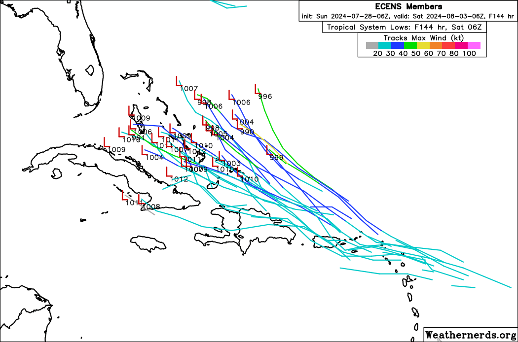
I think part of the problem with current modeling is that we're just not looking at nearly as finite of a disturbance as will likely be the case in the weeks to come. The NHC keeps referring to the interaction between a (ITCZ) disturbance and the approaching wave. I think that the NHC is in fact more primarily focused on the approaching wave around 33W. This wave however more pronounced, appears to be quite shallow at the lower levels and although seemingly anchored by a pronounced mid-level feature, is also abutting dryer air. This north/south wave is hauling off to the west at a pretty good clip but the 850mb vorticity seems stretched out and less pronounced then the ITCZ disturbance further west around 11N & 48W. It seems to me that the NHC is sort of anticipating that the easterly wave with the further north associated broad (and dryer) mid-level feature, will "catch-up" to and pull the better established ITCZ 850mb disturbance up (north) and merge into it.

My thinking is more in-line with Aspen's take on the EURO's forecast track in general here, and this is my reasoning. Overall conditions within the Central and Eastern Atlantic are still transitioning and I still see the eastern TW being to moisture starved to develop on its own. Meanwhile, the disturbance further WSW has what I believe to be a better establish 850mb vorticity and is better "seeded" within a pocket of greater moisture (as evidenced on IR). As fast as the eastern wave would seem to be moving west, it is the associated drier mid-level feature closer to around 16N & 33N that I believe the EURO is broadly reflecting an eventual surface reflection to develop just north of PR or Hispaniola. I am a bit more skeptical on this overall scenario and equally so regarding overall development given the interaction with land. As Aspen alluded to, I think that any cyclogenesis that might occur will be driven more by the disturbance further west, as it is "influenced" (but not merged with) the approaching TW. I think that the disturbance itself could develop in the NE Caribbean but further south and west then what the EURO is projecting. My guess is that by this time tomorrow, we might begin to see NHC's cone shift further south and west as a result.
1 likes   
Andy D

(For official information, please refer to the NHC and NWS products.)

User avatar
Category5Kaiju
Category 5
Category 5
Posts: 4095
Joined: Thu Dec 24, 2020 12:45 pm
Location: Seattle

Re: Possible development in the central Atlantic (0/40)

#115 Postby Category5Kaiju » Sun Jul 28, 2024 10:49 am

LarryWx wrote:The 12Z ICON is its first run with a TC from this. At 180 it has a 1005 mb low moving NW in the direction of the central US GOM coast.


Ahhh...

So the system is Gulf-bound after all. :P
0 likes   
Unless explicitly stated, all info in my posts is based on my own opinions and observations. Tropical storms and hurricanes can be extremely dangerous. Do not think you can beat Mother Nature. Refer to an accredited weather research agency or meteorologist if you need to make serious decisions regarding an approaching storm.

User avatar
mpic
S2K Supporter
S2K Supporter
Posts: 622
Joined: Thu Oct 20, 2005 11:24 am
Location: Splendora, TX

Re: Possible development in the central Atlantic (0/40)

#116 Postby mpic » Sun Jul 28, 2024 10:52 am

Will the African dust have any notable effect on it at all? It sure hasn't prevented all the rain in the Houston area. I have had almost 10 inches in the last week.
0 likes   
Alicia, Rita, Ike, Harvey and Beryl...moved to Splendora lol

Michele B
S2K Supporter
S2K Supporter
Posts: 1114
Joined: Thu Aug 25, 2016 8:08 am
Location: SWFL

Re: Possible development in the central Atlantic (0/40)

#117 Postby Michele B » Sun Jul 28, 2024 10:53 am

aspen wrote:Something to note about the Euro solutions is how long “future Debby” takes to make its turn to the north. It slows down a lot in that corner of the Atlantic by the Bahamas/just north of the GAs, which’ll give it a few full days over toasty 28-29C *if* this solution verifies, which would be concerning giving its proximity to the East Coast.

Alternatively, the Euro could be far too north in its track forecasts at this point. I remember it was too north with Laura, showing a track just above the GAs and possibly into Florida while the GFS was further south and ended up verifying.


I’m thinking it has more to do with the large Bermuda high-type ridge and how strong it is once that PTS gets close enough to be influenced to either move west or curve north.
0 likes   
Cleo - 1964, Betsy - 1965, David - 1979, Andrew - 1992, Charlie (Francis, Ivan, Jeanne) - 2004, Irma - 2017, Ian - 2022

User avatar
chaser1
S2K Supporter
S2K Supporter
Posts: 5464
Age: 64
Joined: Sat Oct 15, 2005 5:59 pm
Location: Longwood, Fl

Re: Possible development in the central Atlantic (0/40)

#118 Postby chaser1 » Sun Jul 28, 2024 10:55 am

mpic wrote:
chaser1 wrote:Well, let's not lose sight of good 'ol terra-firma. Land has a tendency to "stop it from really getting going" :P

It only takes a Cat 1 to and Beryl proved that it would take a heck of lot more land to stop it. My area is still trying to dig out of the rubble and subsequent rains that have kept us from doing repairs.


I understand where you're coming from but I don't think you understood my point. Beryl developed over water. Significant land interaction can have a mitigating effect on a developing tropical cyclone as a whole. Beryl had a very significant circulation as is progressed over the Yucatan Peninsula. The disturbance(s) of discussion have not yet developed, and land interaction may just impact that process to an extent that nothing may form. If a TD does develop, there would certainly be less space to become a well-developed tropical storm or hurricane. Not saying it can't or won't happen, but that I think a clear path for this to develop into a Cat 1 hurricane is WAY far from certain.
0 likes   
Andy D

(For official information, please refer to the NHC and NWS products.)

LarryWx
S2K Supporter
S2K Supporter
Posts: 6300
Joined: Sun Sep 07, 2003 2:04 pm
Location: GA

Re: Possible development in the central Atlantic (0/40)

#119 Postby LarryWx » Sun Jul 28, 2024 10:59 am

Fwiw, the composite of tracks posted by another poster earlier in the summer suggests that the area of the CONUS from N central Gulf through FL and E coast as opposed to further W or MX/C America is at highest risk from landfalls when ASO is in weak La Nina territory. That’s where RONI ASO appears to be heading as of now.
1 likes   
Personal Forecast Disclaimer:
The posts in this forum are NOT official forecasts and should not be used as such. They are just the opinion of the poster and may or may not be backed by sound meteorological data. They are NOT endorsed by any professional institution or storm2k.org. For official information, please refer to the NHC and NWS products.

DunedinDave
Tropical Storm
Tropical Storm
Posts: 227
Joined: Fri Aug 25, 2023 10:31 am

Re: Possible development in the central Atlantic (0/40)

#120 Postby DunedinDave » Sun Jul 28, 2024 11:12 am

caneman wrote:Most systems coming from this direction and approach do in fact curve away and with the EUROs track record, I see nothing to lead me to believe that it wont be right. It's the rare one that sneaks through but time will tell and it's still early so we will see.

Agree. I think a strong storm is more likely to go that path.

However, if it goes through the islands and is weak, it’s less likely to pull north. That’s what the ICON and GFS seems to be hinting at. It could actually get destroyed if it goes right through Haiti and the Cuban mountains.
0 likes   


Return to “Talkin' Tropics”

Who is online

Users browsing this forum: LarryWx and 27 guests